Second Deposit LDP
(2) Appendix 7 – Housing Trajectory
Allocations
|
Cluster / Tier |
Settlement |
Site |
Revised LDP Map Reference |
Total Site Capacity 2018-2033 |
Time Lag to construction start in months |
Total Completions (April 2018 - March 2022) |
U/C April 2022 |
Actual Completions |
Short Term |
Medium Term |
Long Term |
|||||||||||||
|
Estimated Completions |
||||||||||||||||||||||||
|
Time period for pre-application discussions / PAC |
Time between submission of planning application and determination |
Time taken from planning consent to the discharge of relevant conditions to enable site construction |
2018-19 |
2019-20 |
2020-21 |
2021-22 |
2022-23 |
2023-24 |
2024-25 |
2025-26 |
2026-27 |
2027-28 |
2028-29 |
2029-30 |
2030-31 |
2031-32 |
2032-33 |
|||||||
|
Cluster 1 |
||||||||||||||||||||||||
|
Tier 1 |
Carmarthen |
Land off Parc y Delyn |
PrC1/h4 |
17 |
6 months |
6 months |
3 months |
0 |
0 |
0 |
0 |
0 |
0 |
0 |
0 |
0 |
0 |
0 |
0 |
0 |
10 |
7 |
0 |
0 |
|
East of Devereaux Drive |
PrC1/h5 |
10 |
6 months |
6 months |
3 months |
0 |
0 |
0 |
0 |
0 |
0 |
0 |
0 |
0 |
0 |
0 |
10 |
0 |
0 |
0 |
0 |
0 |
||
|
Llansteffan Road |
PrC1/h8 |
50 |
6 months |
6 months |
3 months |
0 |
0 |
0 |
0 |
0 |
0 |
0 |
0 |
0 |
25 |
25 |
0 |
0 |
0 |
0 |
0 |
0 |
||
|
Brynhyfryd |
PrC1/h10 |
20 |
6 months |
6 months |
3 months |
0 |
0 |
0 |
0 |
0 |
0 |
0 |
0 |
0 |
0 |
10 |
10 |
0 |
0 |
0 |
0 |
0 |
||
|
Castell Pigyn Road, Abergwili |
PrC1/h12 |
35 |
6 months |
6 months |
3 months |
0 |
0 |
0 |
0 |
0 |
0 |
0 |
0 |
0 |
5 |
10 |
10 |
10 |
0 |
0 |
0 |
0 |
||
|
West Carmarthen |
PrC1/MU1 |
270 |
6 months |
6 months |
6 months |
0 |
0 |
0 |
0 |
0 |
0 |
0 |
0 |
0 |
0 |
0 |
20 |
50 |
50 |
50 |
50 |
50 |
||
|
Pibwrlwyd |
PrC1/MU2 |
247 |
6 months |
12 months |
6 months |
0 |
0 |
0 |
0 |
0 |
0 |
0 |
0 |
0 |
0 |
0 |
0 |
60 |
60 |
55 |
50 |
22 |
||
|
Tier 2 |
Pontyates / Meinciau / Ponthenri |
Cae Canfas, Heol Llanelli |
SeC1/h4 |
8 |
3 months |
6 months |
2 months |
0 |
0 |
0 |
0 |
0 |
0 |
0 |
0 |
0 |
4 |
4 |
0 |
0 |
0 |
0 |
0 |
0 |
|
Land off Heol Glyndwr |
SeC1/h7 |
9 |
3 months |
6 months |
2 months |
0 |
0 |
0 |
0 |
0 |
0 |
0 |
2 |
2 |
2 |
3 |
0 |
0 |
0 |
0 |
0 |
0 |
||
|
Ferryside |
Land to the rear of Parc y Ffynnon |
Sec2/h2 |
12 |
3 months |
6 months |
3 months |
0 |
0 |
0 |
0 |
0 |
0 |
0 |
0 |
0 |
0 |
4 |
4 |
4 |
0 |
0 |
0 |
0 |
|
|
Tier 3 |
Cynwyl Elfed |
Adjacent Fron Heulog |
SuV1/h1 |
5 |
6 months |
6 months |
3 months |
0 |
0 |
0 |
0 |
0 |
0 |
0 |
0 |
0 |
0 |
2 |
2 |
1 |
0 |
0 |
0 |
0 |
|
Land adj. Lleine |
SuV1/h2 |
13 |
6 months |
6 months |
3 months |
0 |
0 |
0 |
0 |
0 |
0 |
0 |
0 |
2 |
2 |
2 |
2 |
2 |
2 |
1 |
0 |
0 |
||
|
Bronwydd |
Land at Troed Rhiw Farm |
SuV4/h1 |
6 |
N/A |
3 months |
1 month |
0 |
0 |
0 |
0 |
0 |
0 |
0 |
0 |
2 |
2 |
2 |
0 |
0 |
0 |
0 |
0 |
0 |
|
|
Peniel |
Aberdeuddwr / Pantyfedwen |
SuV10/h2 |
38 |
3 months |
6 months |
6 months |
0 |
0 |
0 |
0 |
0 |
0 |
0 |
0 |
0 |
10 |
10 |
10 |
8 |
0 |
0 |
0 |
0 |
|
|
Alltwalis |
Land at Alltwalis School |
SuV11/h1 |
12 |
3 months |
4 months |
3 months |
0 |
0 |
0 |
0 |
0 |
0 |
0 |
0 |
12 |
0 |
0 |
0 |
0 |
0 |
0 |
0 |
0 |
|
|
Llanpumsaint |
Adj. Gwyn Villa |
SuV12/h1 |
20 |
3 months |
6 months |
3 months |
0 |
0 |
0 |
0 |
0 |
0 |
0 |
0 |
0 |
0 |
0 |
5 |
5 |
5 |
5 |
0 |
0 |
|
|
Llandre |
SuV12/h2 |
4 |
N/A |
6 months |
3 months |
0 |
0 |
0 |
0 |
0 |
0 |
0 |
0 |
0 |
0 |
1 |
1 |
1 |
1 |
0 |
0 |
0 |
||
|
Rhydargaeau |
Cefn Farm |
SuV14/h1 |
17 |
3 months |
3 months |
3 months |
0 |
0 |
0 |
0 |
0 |
0 |
0 |
0 |
0 |
4 |
4 |
4 |
5 |
0 |
0 |
0 |
0 |
|
|
Capel Dewi |
Llwynddewi Road |
SuV16/h1 |
2 |
N/A |
3 months |
3 months |
0 |
0 |
0 |
0 |
0 |
0 |
0 |
0 |
1 |
1 |
0 |
0 |
0 |
0 |
0 |
0 |
0 |
|
|
Nantgaredig |
Rear of former joinery, Station Road |
SuV17/h1 |
35 |
3 months |
3 months |
3 months |
0 |
0 |
0 |
0 |
0 |
0 |
0 |
0 |
0 |
0 |
0 |
10 |
15 |
10 |
0 |
0 |
0 |
|
|
Llanddarog |
Land adj. and the r/o Haulfan |
SuV19/h2 |
10 |
3 months |
6 months |
3 months |
0 |
0 |
0 |
0 |
0 |
0 |
0 |
0 |
0 |
0 |
0 |
2 |
4 |
4 |
0 |
0 |
0 |
|
|
Porthyrhyd |
Land adjacent to Llwynhenry Farm |
SuV20/h1 |
6 |
N/A |
6 months |
2 months |
0 |
0 |
0 |
0 |
0 |
0 |
0 |
0 |
0 |
1 |
1 |
1 |
1 |
1 |
1 |
0 |
0 |
|
|
Total for the cluster |
846 |
0 |
0 |
0 |
0 |
0 |
0 |
0 |
2 |
19 |
56 |
78 |
91 |
166 |
143 |
119 |
100 |
72 |
||||||
|
Cluster 2 |
||||||||||||||||||||||||
|
Tier 1 |
Llanelli |
Beech Grove, Pwll |
PrC2/h1 |
10 |
3 months |
6 months |
2 months |
0 |
0 |
0 |
0 |
0 |
0 |
0 |
0 |
0 |
0 |
5 |
5 |
0 |
0 |
0 |
0 |
0 |
|
Land adjacent The Dell, Furnace |
PrC2/h10 |
13 |
3 months |
6 months |
2 months |
0 |
0 |
0 |
0 |
0 |
0 |
0 |
0 |
0 |
6 |
7 |
0 |
0 |
0 |
0 |
0 |
0 |
||
|
Ynys Las, Llwynhendy |
PrC2/h16 |
33 |
3 months |
6 months |
3 months |
0 |
0 |
0 |
0 |
0 |
0 |
0 |
0 |
0 |
0 |
0 |
16 |
17 |
0 |
0 |
0 |
0 |
||
|
Harddfan |
PrC2/h20 |
6 |
N/A |
6 months |
3 months |
0 |
0 |
0 |
0 |
0 |
0 |
0 |
6 |
0 |
0 |
0 |
0 |
0 |
0 |
0 |
0 |
0 |
||
|
Dafen East Gateway |
PrC2/h23 |
150 |
6 months |
8 months |
6 months |
0 |
0 |
0 |
0 |
0 |
0 |
0 |
20 |
65 |
65 |
0 |
0 |
0 |
0 |
0 |
0 |
0 |
||
|
Pentre Awel |
PrC2/SS1 |
240 |
6 months |
8 months |
6 months |
0 |
0 |
0 |
0 |
0 |
0 |
0 |
0 |
0 |
60 |
60 |
60 |
60 |
0 |
0 |
0 |
0 |
||
|
Tier 2 |
Kidwelly |
Land off Priory Street |
SeC3/h2 |
20 |
6 months |
6 months |
3 months |
0 |
0 |
0 |
0 |
0 |
0 |
0 |
0 |
0 |
0 |
0 |
0 |
0 |
0 |
8 |
8 |
4 |
|
Llys Felin |
SeC3/h3 |
15 |
3 months |
6 months |
3 months |
0 |
0 |
0 |
0 |
0 |
0 |
0 |
0 |
5 |
5 |
5 |
0 |
0 |
0 |
0 |
0 |
0 |
||
|
Hendy |
Land between Clayton Road and East of Bronallt Road |
SeC6/h2 |
12 |
6 months |
6 months |
3 months |
0 |
0 |
0 |
0 |
0 |
0 |
0 |
0 |
0 |
0 |
0 |
6 |
6 |
0 |
0 |
0 |
0 |
|
|
Llangennech |
Golwg Yr Afon |
SeC7/h3 |
50 |
3 months |
6 months |
3 months |
0 |
0 |
0 |
0 |
0 |
0 |
0 |
0 |
0 |
25 |
25 |
0 |
0 |
0 |
0 |
0 |
0 |
|
|
Opposite Parc Morlais |
SeC7/h4 |
32 |
3 months |
6 months |
3 months |
0 |
0 |
0 |
0 |
0 |
0 |
0 |
0 |
15 |
17 |
0 |
0 |
0 |
0 |
0 |
0 |
0 |
||
|
Maesydderwen |
SeC7/h5 |
5 |
N/A |
6 months |
3 months |
0 |
0 |
0 |
0 |
0 |
0 |
2 |
3 |
0 |
0 |
0 |
0 |
0 |
0 |
0 |
||||
|
Trimsaran / Carway |
Cae Linda |
SeC8/h2 |
25 |
3 months |
9 months |
6 months |
0 |
0 |
0 |
0 |
0 |
0 |
0 |
0 |
0 |
0 |
5 |
5 |
5 |
5 |
5 |
0 |
0 |
|
|
Tier 3 |
Mynyddygarreg |
Land adjacent to Ty Newydd, Meinciau Road |
SuV22/h2 |
8 |
N/A |
6 months |
3 months |
0 |
0 |
0 |
0 |
0 |
0 |
0 |
0 |
0 |
0 |
2 |
2 |
2 |
2 |
0 |
0 |
0 |
|
Five Roads / Horeb |
Adjacent Little Croft |
SuV23/h2 |
25 |
6 months |
6 months |
3 months |
0 |
0 |
0 |
0 |
0 |
0 |
0 |
0 |
0 |
0 |
0 |
0 |
0 |
0 |
5 |
10 |
10 |
|
|
Total for the cluster |
644 |
0 |
0 |
0 |
0 |
0 |
0 |
0 |
26 |
87 |
181 |
109 |
94 |
90 |
7 |
18 |
18 |
14 |
||||||
|
Cluster 3 |
||||||||||||||||||||||||
|
Tier 1 |
Ammanford (inc Betws and Penybanc) |
Land at r/o No 16-20 & 24-30 Betws Road |
PrC3/h1 |
9 |
N/A |
N/A |
N/A |
0 |
0 |
0 |
0 |
0 |
0 |
0 |
0 |
0 |
0 |
0 |
0 |
0 |
3 |
3 |
3 |
0 |
|
Land Adjoining Maes Ifan, Maesquarre Road |
PrC3/h6 |
18 |
6 months |
6 months |
3 months |
0 |
0 |
0 |
0 |
0 |
0 |
0 |
0 |
0 |
0 |
0 |
6 |
6 |
6 |
0 |
0 |
0 |
||
|
Cefneithin |
Land off Heol y Parc |
PrC3/h8 |
18 |
6 months |
6 months |
3 months |
0 |
0 |
0 |
0 |
0 |
0 |
0 |
0 |
0 |
0 |
6 |
6 |
6 |
0 |
0 |
0 |
0 |
|
|
Drefach (Tumble) |
Nantydderwen |
PrC3/h14 |
33 |
3 months |
6 months |
3 months |
0 |
0 |
0 |
0 |
0 |
0 |
0 |
0 |
0 |
0 |
0 |
10 |
10 |
13 |
0 |
0 |
0 |
|
|
Land off Heol Caegwyn |
PrC3/h15 |
5 |
N/A |
4 months |
1 month |
0 |
0 |
0 |
0 |
0 |
0 |
0 |
1 |
2 |
2 |
0 |
0 |
0 |
0 |
0 |
0 |
0 |
||
|
Gorslas |
Land adjoining Brynlluan |
PrC3/h18 |
29 |
3 months |
6 months |
3 months |
0 |
0 |
0 |
0 |
0 |
0 |
0 |
0 |
0 |
0 |
0 |
0 |
9 |
10 |
10 |
0 |
0 |
|
|
Llandybie |
Land north of Maespiode |
PrC3/h20 |
45 |
6 months |
6 months |
3 months |
0 |
0 |
0 |
0 |
0 |
0 |
0 |
10 |
10 |
10 |
10 |
5 |
0 |
0 |
0 |
0 |
0 |
|
|
Penygroes |
Emlyn Brickworks |
PrC3/MU1 |
177 |
6 months |
6 months |
3 months |
0 |
0 |
0 |
0 |
0 |
0 |
0 |
0 |
0 |
0 |
17 |
40 |
40 |
40 |
40 |
|||
|
Saron |
Land off Parc-y-Mynydd |
PrC3/h26 |
15 |
3 months |
6 months |
3 months |
0 |
0 |
0 |
0 |
0 |
0 |
0 |
0 |
0 |
0 |
0 |
5 |
5 |
5 |
0 |
0 |
0 |
|
|
Land off Nant-y-Ci Road |
PrC3/h27 |
18 |
3 months |
6 months |
3 months |
0 |
0 |
0 |
0 |
0 |
0 |
0 |
0 |
0 |
0 |
0 |
0 |
0 |
3 |
5 |
5 |
5 |
||
|
Tumble |
Land at Factory site between No. 22 & 28 Bethesda Road |
PrC3/h28 |
30 |
3 months |
6 months |
3 months |
0 |
0 |
0 |
0 |
0 |
0 |
0 |
10 |
10 |
10 |
0 |
0 |
0 |
0 |
0 |
|||
|
Tier 2 |
Brynamman |
Heol Gelynen |
SeC9/h2 |
8 |
N/A |
6 months |
3 months |
0 |
0 |
0 |
0 |
0 |
0 |
0 |
0 |
0 |
0 |
0 |
0 |
0 |
0 |
0 |
4 |
4 |
|
Tier 2 |
Pontyberem |
Land off Heol Llannon |
SeC11/h1 |
15 |
3 months |
6 months |
3 months |
0 |
0 |
0 |
0 |
0 |
0 |
0 |
0 |
0 |
0 |
4 |
4 |
4 |
3 |
0 |
||
|
Tier 3 |
Llanedi |
Rear of 16 Y Garreg Llwyd |
SuV26/h1 |
11 |
3 months |
18 months |
3 months |
0 |
0 |
0 |
0 |
0 |
0 |
0 |
3 |
4 |
4 |
0 |
0 |
0 |
0 |
0 |
0 |
0 |
|
Carmel |
Land adjacent to Tŷ Newydd |
SuV27/h1 |
5 |
N/A |
3 months |
1 month |
0 |
0 |
0 |
0 |
0 |
0 |
0 |
0 |
1 |
2 |
2 |
0 |
0 |
0 |
0 |
0 |
0 |
|
|
Ystradowen |
Land off Pant y Brwyn |
SuV30/h1 |
5 |
N/A |
3 months |
1 month |
0 |
0 |
0 |
0 |
0 |
0 |
0 |
2 |
3 |
0 |
0 |
0 |
0 |
0 |
0 |
0 |
0 |
|
|
Total for the cluster |
441 |
0 |
0 |
0 |
0 |
0 |
0 |
0 |
16 |
20 |
28 |
28 |
42 |
57 |
84 |
62 |
55 |
49 |
||||||
|
Cluster 4 |
||||||||||||||||||||||||
|
Tier 2 |
Newcastle Emlyn |
Trem y Ddol |
SeC12/h1 |
17 |
3 months |
6 months |
3 months |
0 |
0 |
0 |
0 |
0 |
0 |
0 |
0 |
0 |
0 |
3 |
4 |
4 |
4 |
2 |
0 |
0 |
|
Land to r/o Dolcoed |
SeC12/h3 |
20 |
3 months |
6 months |
3 months |
0 |
0 |
0 |
0 |
0 |
0 |
0 |
0 |
0 |
0 |
4 |
4 |
4 |
4 |
4 |
0 |
0 |
||
|
Llanybydder |
Adj. Y Neuadd |
SeC13/h1 |
10 |
3 months |
6 months |
1 month |
0 |
0 |
0 |
0 |
0 |
0 |
0 |
0 |
0 |
2 |
2 |
2 |
2 |
2 |
0 |
0 |
0 |
|
|
Pencader |
Blossom Garage |
SeC14/h1 |
20 |
3 months |
6 months |
1 month |
0 |
0 |
0 |
0 |
0 |
0 |
0 |
5 |
5 |
5 |
5 |
0 |
0 |
0 |
0 |
0 |
0 |
|
|
Land adj Maescader |
SeC14/h2 |
24 |
3 months |
6 months |
3 months |
0 |
0 |
0 |
0 |
0 |
0 |
0 |
0 |
0 |
0 |
0 |
6 |
6 |
6 |
6 |
0 |
0 |
||
|
Tier 3 |
Llangeler |
Land opp Brogeler |
SuV33/h1 |
5 |
N/A |
6 months |
3 months |
0 |
0 |
0 |
0 |
0 |
0 |
0 |
0 |
0 |
0 |
0 |
2 |
2 |
1 |
0 |
0 |
0 |
|
Saron/Rhos |
Land adj. Arwynfa |
SuV35/h1 |
6 |
N/A |
6 months |
3 months |
0 |
0 |
0 |
0 |
0 |
0 |
0 |
0 |
0 |
0 |
5 |
1 |
0 |
0 |
0 |
0 |
0 |
|
|
Llanllwni |
Cae Pensarn Helen |
SuV36/h1 |
6 |
N/A |
3 months |
3 month |
0 |
0 |
0 |
0 |
0 |
0 |
0 |
0 |
0 |
0 |
2 |
2 |
2 |
0 |
0 |
0 |
0 |
|
|
Land at Bryndulais |
SuV36/h2 |
16 |
3 months |
3 months |
3 months |
0 |
0 |
0 |
0 |
0 |
0 |
0 |
5 |
5 |
6 |
0 |
0 |
0 |
0 |
0 |
0 |
0 |
||
|
Cwmann |
Land south of Cae Coedmor |
SuV37/h2 |
20 |
3 months |
3 months |
3 months |
0 |
0 |
0 |
0 |
0 |
0 |
0 |
0 |
0 |
5 |
5 |
5 |
5 |
0 |
0 |
0 |
0 |
|
|
Land adjacent to Lleinau |
SuV37/h3 |
10 |
3 months |
3 months |
3 months |
0 |
0 |
0 |
0 |
0 |
0 |
0 |
0 |
0 |
0 |
5 |
5 |
0 |
0 |
0 |
0 |
0 |
||
|
Capel Iwan |
Maes y Bryn |
SuV38/h1 |
6 |
3 months |
3 months |
3 months |
0 |
0 |
0 |
0 |
0 |
0 |
0 |
0 |
0 |
2 |
2 |
2 |
0 |
0 |
0 |
0 |
0 |
|
|
Llanfihangel ar arth |
Adj Yr Hendre |
SuV39/h1 |
7 |
N/A |
3 months |
3 months |
0 |
0 |
0 |
0 |
0 |
0 |
0 |
0 |
0 |
0 |
1 |
2 |
2 |
2 |
0 |
0 |
0 |
|
|
New Inn |
Blossom Inn |
SuV43/h1 |
5 |
3 months |
3 months |
3 months |
0 |
0 |
0 |
0 |
0 |
0 |
0 |
1 |
2 |
2 |
0 |
0 |
0 |
0 |
0 |
0 |
0 |
|
|
Total for the cluster |
172 |
0 |
0 |
0 |
0 |
0 |
0 |
0 |
11 |
12 |
22 |
34 |
35 |
27 |
19 |
12 |
0 |
0 |
||||||
|
Cluster 5 |
||||||||||||||||||||||||
|
Tier 2 |
Llandovery |
Land adjacent to Bryndeilog, Tywi Avenue |
SeC15/h2 |
8 |
N/A |
3 months |
3 months |
0 |
0 |
0 |
0 |
0 |
0 |
0 |
0 |
0 |
0 |
0 |
0 |
0 |
0 |
3 |
3 |
2 |
|
Llandeilo |
Llandeilo Northern Quarter |
SeC16/h1 |
27 |
6 months |
6 months |
3 months |
0 |
0 |
0 |
0 |
0 |
0 |
0 |
0 |
0 |
0 |
10 |
10 |
7 |
0 |
0 |
0 |
0 |
|
|
Llangadog |
Land opp. Llangadog C.P School |
SeC17/h1 |
16 |
6 months |
6 months |
3 months |
0 |
0 |
0 |
0 |
0 |
0 |
0 |
0 |
0 |
4 |
4 |
4 |
4 |
0 |
0 |
0 |
0 |
|
|
Land off Heol Pendref |
Sec17/h2 |
8 |
N/A |
6 months |
3 months |
0 |
0 |
0 |
0 |
0 |
0 |
0 |
0 |
0 |
0 |
2 |
2 |
4 |
0 |
0 |
0 |
0 |
||
|
Tier 3 |
Cwmifor |
Opp. Village Hall |
SuV51/h1 |
8 |
N/A |
12 months |
3 months |
0 |
0 |
0 |
0 |
0 |
0 |
0 |
0 |
0 |
0 |
0 |
0 |
2 |
2 |
3 |
1 |
0 |
|
Total for the cluster |
67 |
0 |
0 |
0 |
0 |
0 |
0 |
0 |
0 |
0 |
4 |
16 |
16 |
17 |
2 |
6 |
4 |
2 |
||||||
|
Cluster 6 |
||||||||||||||||||||||||
|
Tier 2 |
St Clears / Pwll Trap |
Adjacent to Brittania Terrace |
SeC18/h1 |
60 |
6 months |
8 months |
3 months |
0 |
0 |
0 |
0 |
0 |
0 |
0 |
0 |
0 |
0 |
0 |
0 |
25 |
25 |
10 |
0 |
0 |
|
Land adjacent to Cefn Maes |
SeC18/h3 |
100 |
6 months |
6 months |
3 months |
0 |
0 |
0 |
0 |
0 |
0 |
0 |
0 |
0 |
40 |
40 |
20 |
0 |
0 |
0 |
0 |
0 |
||
|
Land at Heol Llaindelyn |
SeC18/h4 |
6 |
N/A |
3 months |
1 month |
0 |
0 |
0 |
0 |
0 |
0 |
0 |
0 |
0 |
1 |
1 |
1 |
1 |
1 |
1 |
0 |
0 |
||
|
Land adjacent to Gwynfa, Station Road |
SeC18/h5 |
8 |
N/A |
3 months |
1 month |
0 |
0 |
0 |
0 |
0 |
0 |
0 |
0 |
0 |
0 |
2 |
2 |
2 |
2 |
0 |
0 |
0 |
||
|
Land to the rear of Station Road |
SeC18/h6 |
25 |
6 months |
6 months |
3 months |
0 |
0 |
0 |
0 |
0 |
0 |
0 |
0 |
0 |
0 |
0 |
0 |
0 |
0 |
0 |
15 |
10 |
||
|
Land adjacent to Gardde Fields |
SeC18/h7 |
8 |
N/A |
3 months |
1 month |
0 |
0 |
0 |
0 |
0 |
0 |
0 |
0 |
0 |
2 |
2 |
2 |
2 |
0 |
0 |
0 |
0 |
||
|
Whitland |
Land at Park View, Trevaughan |
SeC19/h1 |
8 |
N/A |
3 months |
1 month |
0 |
0 |
0 |
0 |
0 |
0 |
0 |
0 |
0 |
0 |
0 |
4 |
4 |
0 |
0 |
0 |
0 |
|
|
Land at Whitland Creamery |
SeC19/h2 |
20 |
N/A |
6 months |
3 months |
0 |
0 |
0 |
0 |
0 |
0 |
0 |
0 |
0 |
0 |
0 |
0 |
0 |
10 |
10 |
0 |
0 |
||
|
Laugharne |
Land off Clifton Street |
SeC20/h3 |
6 |
N/A |
3 months |
3 months |
0 |
0 |
0 |
0 |
0 |
0 |
0 |
0 |
0 |
0 |
0 |
0 |
0 |
0 |
2 |
2 |
2 |
|
|
Tier 3 |
Glandy Cross |
Land to the north of Cross Inn P.H |
SuV55/h2 |
6 |
N/A |
6 months |
3 months |
0 |
0 |
0 |
0 |
0 |
0 |
0 |
0 |
0 |
0 |
0 |
3 |
3 |
0 |
0 |
0 |
0 |
|
Efailwen |
Land to the r/o Talar Wen |
SuV56/h1 |
6 |
N/A |
3 months |
2 months |
0 |
0 |
0 |
0 |
0 |
0 |
0 |
0 |
0 |
1 |
1 |
1 |
1 |
1 |
1 |
0 |
0 |
|
|
Meidrim |
Land adj. to Lon Dewi |
SuV58/h1 |
10 |
3 months |
6 months |
3 months |
0 |
0 |
0 |
0 |
0 |
0 |
0 |
0 |
10 |
0 |
0 |
0 |
0 |
0 |
0 |
0 |
0 |
|
|
Land off Drefach Road |
SuV58/h2 |
14 |
3 months |
4 months |
2 months |
0 |
0 |
0 |
0 |
0 |
0 |
0 |
0 |
0 |
0 |
2 |
2 |
2 |
2 |
2 |
2 |
2 |
||
|
Bancyfelin |
North of Maes y Llewod |
SuV59/h2 |
19 |
3 months |
6 months |
3 months |
0 |
0 |
0 |
0 |
0 |
0 |
0 |
0 |
0 |
9 |
10 |
0 |
0 |
0 |
0 |
0 |
0 |
|
|
Llangynog |
Land at College Bach |
SuV60/h1 |
6 |
N/A |
3 months |
3 months |
0 |
0 |
0 |
0 |
0 |
0 |
0 |
0 |
0 |
0 |
0 |
1 |
1 |
1 |
1 |
1 |
1 |
|
|
Pendine |
Land at Nieuport Farm |
SuV61/h1 |
10 |
6 months |
6 months |
3 months |
0 |
0 |
0 |
0 |
0 |
0 |
0 |
0 |
3 |
4 |
3 |
0 |
0 |
0 |
0 |
0 |
0 |
|
|
Total for the cluster |
312 |
0 |
0 |
0 |
0 |
0 |
0 |
0 |
0 |
13 |
57 |
61 |
36 |
41 |
42 |
27 |
20 |
15 |
||||||
|
Overall Housing Allocation total |
2482 |
0 |
0 |
0 |
0 |
0 |
0 |
0 |
55 |
151 |
348 |
326 |
314 |
398 |
297 |
244 |
197 |
152 |
||||||
* Sites Allocated as 100% Affordable Schemes
Commitments (Sites with Planning Permission)
|
Cluster / Tier |
Settlement |
Site |
Revised LDP Map Reference |
Outline / Full Planning / Reserved Matters |
Site capacity |
Under Construction |
2018-19 (Comps) |
2019-20 (Comps) |
2020-21 (Comps) |
2021-22 (Comps) |
2022-23 |
2023-24 |
2024-25 |
2025-26 |
2026-27 |
2027-28 |
2028-29 |
2029-30 |
2030-31 |
2031-32 |
2032-33 |
|
|
Cluster 1 |
||||||||||||||||||||||
|
Tier 1 |
Carmarthen |
Springfield Road |
PrC1/h2 |
outline |
29 |
0 |
0 |
0 |
0 |
0 |
0 |
9 |
10 |
10 |
0 |
0 |
0 |
0 |
0 |
0 |
0 |
|
|
113 Priory Street |
PrC1/h3 |
Full |
37 |
0 |
0 |
37 |
0 |
0 |
0 |
0 |
0 |
0 |
0 |
0 |
0 |
0 |
0 |
0 |
0 |
|||
|
Penybont Farm, Llysonnen Road |
PrC1/h7 |
Full |
9 |
0 |
0 |
0 |
0 |
0 |
9 |
0 |
0 |
0 |
0 |
0 |
0 |
0 |
0 |
0 |
0 |
|||
|
Mounthill |
PrC1/h9 |
Full |
5 |
0 |
0 |
1 |
1 |
0 |
3 |
0 |
0 |
0 |
0 |
0 |
0 |
0 |
0 |
0 |
0 |
|||
|
Rhiw Babell extension |
PrC1/h11 |
Full |
12 |
0 |
0 |
5 |
4 |
3 |
0 |
0 |
0 |
0 |
0 |
0 |
0 |
0 |
0 |
0 |
0 |
|||
|
Bronwydd Road (south) |
PrC1/h14 |
Full |
44 |
0 |
0 |
0 |
8 |
8 |
3 |
25 |
0 |
0 |
0 |
0 |
0 |
0 |
0 |
0 |
0 |
|||
|
Adj Tyle Teg, Llysonnen Road |
PrC1/h15 |
Full |
7 |
0 |
0 |
4 |
1 |
0 |
2 |
0 |
0 |
0 |
0 |
0 |
0 |
0 |
0 |
0 |
0 |
|||
|
Rhiw Babell |
PrC1/h16 |
Outline |
9 |
0 |
0 |
0 |
0 |
0 |
0 |
4 |
5 |
0 |
0 |
0 |
0 |
0 |
0 |
0 |
0 |
|||
|
4-5 Quay Street |
PrC1/h17 |
Full |
5 |
0 |
0 |
0 |
0 |
0 |
0 |
5 |
0 |
0 |
0 |
0 |
0 |
0 |
0 |
0 |
0 |
|||
|
Castell Howell |
PrC1/h18 |
Full |
7 |
0 |
0 |
0 |
0 |
0 |
0 |
0 |
3 |
4 |
0 |
0 |
0 |
0 |
0 |
0 |
0 |
|||
|
Land adjacent Ty Gwynfa |
PrC1/h19 |
Full |
10 |
0 |
0 |
0 |
10 |
0 |
0 |
0 |
0 |
0 |
0 |
0 |
0 |
0 |
0 |
0 |
0 |
|||
|
5-8 Spilman Street |
PrC1/h20 |
Full |
12 |
0 |
0 |
0 |
0 |
0 |
0 |
0 |
0 |
12 |
0 |
0 |
0 |
0 |
0 |
0 |
0 |
|||
|
Clos Tawelan |
PrC1/h21 |
Full |
18 |
0 |
0 |
0 |
0 |
18 |
0 |
0 |
0 |
0 |
0 |
0 |
0 |
0 |
0 |
0 |
0 |
|||
|
West Carmarthen |
PrC1/MU1 |
Various |
430 |
0 |
5 |
70 |
20 |
10 |
0 |
60 |
80 |
80 |
80 |
25 |
0 |
0 |
0 |
0 |
0 |
|||
|
Tier 2 |
Pontyates / Meinciau / Ponthenri |
Lime Grove |
SeC1/h1 |
Outline |
19 |
0 |
0 |
0 |
0 |
0 |
0 |
5 |
5 |
5 |
4 |
0 |
0 |
0 |
0 |
0 |
0 |
|
|
Land adjoining Tabernacle Chapel |
SeC1/h3 |
Outline |
11 |
0 |
0 |
0 |
0 |
0 |
2 |
2 |
2 |
2 |
2 |
1 |
0 |
0 |
0 |
0 |
0 |
|||
|
Land at 8 Heol Llanelli |
SeC1/h5 |
Full |
6 |
0 |
0 |
0 |
0 |
0 |
0 |
0 |
0 |
3 |
3 |
0 |
0 |
0 |
0 |
0 |
0 |
|||
|
Land off Heol Llanelli |
SeC1/h6 |
Outline |
10 |
0 |
0 |
0 |
0 |
0 |
0 |
1 |
2 |
2 |
2 |
1 |
1 |
1 |
0 |
0 |
0 |
|||
|
Ferryside |
Caradog Court |
Sec2/h1 |
Full |
12 |
1 |
1 |
0 |
1 |
0 |
4 |
6 |
0 |
0 |
0 |
0 |
0 |
0 |
0 |
0 |
0 |
||
|
Tier 3 |
Cynwyl Elfed |
Adjacent Fron Heulog |
SuV1/h1 |
1 full, 2 outline |
3 |
0 |
0 |
0 |
0 |
1 |
1 |
1 |
0 |
0 |
0 |
0 |
0 |
0 |
0 |
0 |
0 |
|
|
Llansteffan |
Land to the rear of Maesgriffith |
SuV3/h1 |
Full |
16 |
0 |
0 |
0 |
0 |
0 |
0 |
8 |
8 |
0 |
0 |
0 |
0 |
0 |
0 |
0 |
0 |
||
|
Cwmffrwd |
Land at Maesglasnant |
SuV5/h1 |
Full permissions |
20 |
0 |
9 |
3 |
1 |
1 |
0 |
2 |
2 |
2 |
0 |
0 |
0 |
0 |
0 |
0 |
0 |
||
|
Llangain |
South of Dol y Dderwen |
SuV8/h1 |
Outline permission |
36 |
0 |
0 |
0 |
0 |
0 |
0 |
10 |
10 |
10 |
6 |
0 |
0 |
0 |
0 |
0 |
0 |
||
|
Peniel |
South of Pentre |
SuV10/h1 |
Full |
9 |
0 |
0 |
0 |
0 |
3 |
3 |
3 |
0 |
0 |
0 |
0 |
0 |
0 |
0 |
0 |
0 |
||
|
Llanpumsaint |
Llandre |
SuV14/h2 |
Full |
4 |
1 |
0 |
1 |
0 |
1 |
1 |
1 |
0 |
0 |
0 |
0 |
0 |
0 |
0 |
0 |
0 |
||
|
Rhydargaeau |
Cefn Farm |
SuV14/h1 |
Full |
19 |
0 |
4 |
4 |
5 |
6 |
0 |
0 |
0 |
0 |
0 |
0 |
0 |
0 |
0 |
0 |
0 |
||
|
Llanarthne |
Llanarthne School |
SuV15/h1 |
Full |
8 |
0 |
2 |
3 |
3 |
0 |
0 |
0 |
0 |
0 |
0 |
0 |
0 |
0 |
0 |
0 |
0 |
||
|
Capel Dewi |
Llwynddewi Road |
SuV16/h1 |
Full |
6 |
0 |
0 |
2 |
2 |
2 |
0 |
0 |
0 |
0 |
0 |
0 |
0 |
0 |
0 |
0 |
0 |
||
|
Pontargothi |
Land off A40, Pontargothi |
SuV18/h1 |
Full |
15 |
0 |
0 |
0 |
0 |
0 |
0 |
5 |
5 |
5 |
0 |
0 |
0 |
0 |
0 |
0 |
0 |
||
|
Llanddarog |
Land Opp. Village Hall |
SuV19/h1 |
RM |
16 |
0 |
0 |
0 |
0 |
0 |
0 |
3 |
5 |
5 |
3 |
0 |
0 |
0 |
0 |
0 |
0 |
||
|
Total for the cluster |
844 |
2 |
21 |
130 |
56 |
53 |
28 |
150 |
137 |
140 |
100 |
27 |
1 |
1 |
0 |
0 |
0 |
|||||
|
Cluster 2 |
||||||||||||||||||||||
|
Tier 1 |
Llanelli |
Former Laboratory Pen y Fai Lane |
PrC2/h2 |
RM |
13 |
4 |
0 |
0 |
0 |
0 |
7 |
6 |
0 |
0 |
0 |
0 |
0 |
0 |
0 |
0 |
0 |
|
|
Parc y Strade |
PrC2/h3 |
RM |
94 |
0 |
24 |
70 |
0 |
0 |
0 |
0 |
0 |
0 |
0 |
0 |
0 |
0 |
0 |
0 |
0 |
|||
|
North Dock (inc former Pontrilas) |
PrC2/h4 |
Outline |
210 |
0 |
0 |
0 |
0 |
0 |
0 |
0 |
0 |
20 |
20 |
20 |
30 |
30 |
30 |
30 |
30 |
|||
|
107 Station Road |
PrC2/h6 |
Full |
7 |
0 |
7 |
0 |
0 |
0 |
0 |
0 |
0 |
0 |
0 |
0 |
0 |
0 |
0 |
0 |
0 |
|||
|
13-15 Station Road |
PrC2/h7 |
Full |
9 |
0 |
0 |
0 |
9 |
0 |
0 |
0 |
0 |
0 |
0 |
0 |
0 |
0 |
0 |
0 |
0 |
|||
|
*3-5 Goring Road |
PrC2/h9 |
Full |
8 |
0 |
0 |
8 |
0 |
0 |
0 |
0 |
0 |
0 |
0 |
0 |
0 |
0 |
0 |
0 |
0 |
|||
|
*Llys yr Hen Felin, Town Centre |
PrC2/h12 |
Full |
26 |
0 |
0 |
15 |
5 |
6 |
0 |
0 |
0 |
0 |
0 |
0 |
0 |
0 |
0 |
0 |
0 |
|||
|
*Land off Frondeg Terrace |
PrC2/h13 |
Full |
29 |
0 |
2 |
27 |
0 |
0 |
0 |
0 |
0 |
0 |
0 |
0 |
0 |
0 |
0 |
0 |
0 |
|||
|
Rear of 22c,22d and 22e Llwynhendy Road |
PrC2/h14 |
Full |
6 |
0 |
0 |
4 |
0 |
2 |
0 |
0 |
0 |
0 |
0 |
0 |
0 |
0 |
0 |
0 |
0 |
|||
|
Maesarddafen Road / Erw Las, Llwynhendy |
PrC2/h15 |
Outline permission |
94 |
0 |
0 |
0 |
0 |
0 |
0 |
0 |
30 |
30 |
34 |
0 |
0 |
0 |
0 |
0 |
0 |
|||
|
*Dylan, Trallwm |
PrC2/h18 |
built |
32 |
0 |
0 |
20 |
4 |
8 |
0 |
0 |
0 |
0 |
0 |
0 |
0 |
0 |
0 |
0 |
0 |
|||
|
Genwen, Bryn |
PrC2/h19 |
built |
240 |
0 |
52 |
132 |
51 |
5 |
0 |
0 |
0 |
0 |
0 |
0 |
0 |
0 |
0 |
0 |
0 |
|||
|
Maes Y Bryn, Bryn |
PrC2/h21 |
Full |
34 |
0 |
8 |
26 |
0 |
0 |
0 |
0 |
0 |
0 |
0 |
0 |
0 |
0 |
0 |
0 |
0 |
|||
|
Cwm y Nant, Dafen |
PrC2/h22 |
outline |
202 |
0 |
0 |
0 |
0 |
0 |
0 |
0 |
0 |
40 |
40 |
41 |
41 |
40 |
0 |
0 |
0 |
|||
|
Clos Ffordd Fach |
PrC2/h24 |
Full planning |
13 |
0 |
0 |
0 |
0 |
0 |
4 |
5 |
4 |
0 |
0 |
0 |
0 |
0 |
0 |
0 |
0 |
|||
|
Land off Clos-y-Berllan |
PrC2/h25 |
Full Planning |
20 |
0 |
0 |
0 |
0 |
0 |
0 |
15 |
5 |
0 |
0 |
0 |
0 |
0 |
0 |
0 |
0 |
|||
|
YMCA MU SITE |
PrC2/h26 |
Full planning |
8 |
0 |
0 |
0 |
0 |
0 |
8 |
0 |
0 |
0 |
0 |
0 |
0 |
0 |
0 |
0 |
0 |
|||
|
42 Stepney Street |
PrC2/h27 |
Full Planning |
8 |
0 |
0 |
0 |
0 |
0 |
8 |
0 |
0 |
0 |
0 |
0 |
0 |
0 |
0 |
0 |
0 |
|||
|
Heol y Graig, Llwynhendy |
PrC2/h28 |
Various Planning |
5 |
0 |
0 |
0 |
0 |
0 |
1 |
1 |
1 |
1 |
1 |
0 |
0 |
0 |
0 |
0 |
0 |
|||
|
Adjacent to No 19 Llwynhendy Road |
PrC2/h29 |
Full |
6 |
0 |
0 |
0 |
0 |
0 |
0 |
0 |
3 |
3 |
0 |
0 |
0 |
0 |
0 |
0 |
0 |
|||
|
Tier 2 |
Kidwelly |
Llys Felin |
SeC3/h3 |
Various Planning |
9 |
3 |
0 |
0 |
0 |
6 |
3 |
0 |
0 |
0 |
0 |
0 |
0 |
0 |
0 |
0 |
0 |
|
|
Land at Former Dinas Yard |
SeC3/h4 |
RM |
71 |
0 |
0 |
0 |
0 |
0 |
0 |
0 |
10 |
20 |
20 |
21 |
0 |
0 |
0 |
0 |
0 |
|||
|
Burry Port |
Gwdig Farm |
SeC4/h1 |
Full |
105 |
13 |
0 |
0 |
35 |
57 |
13 |
0 |
0 |
0 |
0 |
0 |
0 |
0 |
0 |
0 |
0 |
||
|
Burry Port Harbourside |
SeC4/h2 |
364 |
0 |
0 |
0 |
0 |
0 |
0 |
0 |
0 |
45 |
45 |
46 |
46 |
46 |
46 |
45 |
45 |
||||
|
Glanmor Terrace |
SeC4/h3 |
Full |
32 |
0 |
0 |
0 |
32 |
0 |
0 |
0 |
0 |
0 |
0 |
0 |
0 |
0 |
0 |
0 |
0 |
|||
|
Pembrey |
Garreglwyd |
Sec5/h1 |
Full |
14 |
0 |
0 |
14 |
0 |
0 |
0 |
0 |
0 |
0 |
0 |
0 |
0 |
0 |
0 |
0 |
0 |
||
|
Awel y Mynydd |
Sec5/h2 |
Full |
100 |
0 |
0 |
0 |
0 |
0 |
20 |
40 |
40 |
0 |
0 |
0 |
0 |
0 |
0 |
0 |
0 |
|||
|
Hendy / Fforest |
Llwyngwern |
SeC6/h1 |
Full / Completed |
20 |
0 |
20 |
0 |
0 |
0 |
0 |
0 |
0 |
0 |
0 |
0 |
0 |
0 |
0 |
0 |
0 |
||
|
Land between Clayton Road and East of Bronallt Road |
SeC6/h2 |
Full |
8 |
0 |
0 |
2 |
2 |
2 |
2 |
0 |
0 |
0 |
0 |
0 |
0 |
0 |
0 |
0 |
0 |
|||
|
Bronallt Road |
SeC6/h3 |
Various Permissions |
6 |
1 |
4 |
0 |
0 |
0 |
1 |
1 |
0 |
0 |
0 |
0 |
0 |
0 |
0 |
0 |
0 |
|||
|
Adjacent to Clos Benallt Fawr, Fforest |
SeC6/h4 |
Full |
35 |
0 |
0 |
0 |
20 |
15 |
0 |
0 |
0 |
0 |
0 |
0 |
0 |
0 |
0 |
0 |
0 |
|||
|
Llangennech |
Box Farm |
SeC7/h1 |
outline with a Voc |
7 |
0 |
0 |
0 |
0 |
0 |
0 |
0 |
3 |
4 |
0 |
0 |
0 |
0 |
0 |
0 |
0 |
||
|
Trimsaran / Carway |
Ffos Las |
SeC8/h1 |
Full |
159 |
0 |
20 |
40 |
70 |
29 |
0 |
0 |
0 |
0 |
0 |
0 |
0 |
0 |
0 |
0 |
0 |
||
|
Cae Linda |
SeC8/h2 |
Full |
20 |
1 |
0 |
1 |
3 |
0 |
1 |
5 |
5 |
5 |
0 |
0 |
0 |
0 |
0 |
0 |
0 |
|||
|
Golwg Gwendraeth |
SeC8/h3 |
RM |
141 |
0 |
0 |
0 |
0 |
0 |
0 |
30 |
30 |
30 |
30 |
21 |
0 |
0 |
0 |
0 |
0 |
|||
|
Tier 3 |
Mynyddygarreg |
Gwenllian Gardens |
SuV22/h1 |
25 |
13 |
0 |
0 |
0 |
0 |
15 |
10 |
0 |
0 |
0 |
0 |
0 |
0 |
0 |
0 |
0 |
||
|
Five Roads / Horeb |
Clos y Parc |
SuV23/h1 |
16 |
2 |
0 |
0 |
0 |
14 |
2 |
0 |
0 |
0 |
0 |
0 |
0 |
0 |
0 |
0 |
0 |
|||
|
Total for the cluster |
2196 |
37 |
137 |
359 |
231 |
144 |
85 |
113 |
131 |
198 |
190 |
149 |
117 |
116 |
76 |
75 |
75 |
|||||
|
Cluster 3 |
||||||||||||||||||||||
|
Tier 1 |
Ammanford (inc Betws and Penybanc) |
Former Petrol Station, Wind Street |
PrC3/h2 |
Full |
6 |
0 |
6 |
0 |
0 |
0 |
0 |
0 |
0 |
0 |
0 |
0 |
0 |
0 |
0 |
0 |
0 |
|
|
Land at Gwynfryn Fawr |
PrC3/h3 |
Full |
28 |
0 |
0 |
0 |
0 |
28 |
0 |
0 |
0 |
0 |
0 |
0 |
0 |
0 |
0 |
0 |
0 |
|||
|
Land at Tirychen Farm |
PrC3/h4 |
Outline |
150 |
0 |
0 |
0 |
0 |
0 |
0 |
0 |
30 |
30 |
30 |
30 |
30 |
0 |
0 |
0 |
0 |
|||
|
Yr Hen Felin, Pontamman Road |
PrC3/h5 |
Full |
6 |
0 |
0 |
2 |
0 |
4 |
0 |
0 |
0 |
0 |
0 |
0 |
0 |
0 |
0 |
0 |
0 |
|||
|
Llys Dolgader |
PrC3/h33 |
9 |
0 |
0 |
0 |
6 |
3 |
0 |
0 |
0 |
0 |
0 |
0 |
0 |
0 |
0 |
0 |
0 |
||||
|
Betws Colliery |
PrC3/h36 |
RM |
66 |
0 |
0 |
0 |
0 |
0 |
0 |
0 |
0 |
0 |
0 |
0 |
22 |
22 |
22 |
0 |
0 |
|||
|
Castell yr Rhingyll |
Clos y Gât |
PrC3/h34 |
Full |
5 |
0 |
0 |
2 |
2 |
1 |
0 |
0 |
0 |
0 |
0 |
0 |
0 |
0 |
0 |
0 |
0 |
||
|
Cross Hands |
Land adjacent to Maesyrhaf |
PrC3/h9 |
Full |
5 |
0 |
0 |
0 |
0 |
0 |
0 |
0 |
5 |
0 |
0 |
0 |
0 |
0 |
0 |
0 |
0 |
||
|
Ffordd y Neuadd & Clos yr Eithin |
PrC3/h11 |
Full |
60 |
11 |
0 |
0 |
18 |
31 |
11 |
0 |
0 |
0 |
0 |
0 |
0 |
0 |
0 |
0 |
0 |
|||
|
Land adjoining A48 and Heol y Parc |
PrC3/h12 |
Full |
9 |
0 |
0 |
0 |
0 |
0 |
0 |
5 |
4 |
0 |
0 |
0 |
0 |
0 |
0 |
0 |
0 |
|||
|
Land at Heol Cae Pownd |
PrC3/h13 |
RM |
135 |
0 |
34 |
27 |
0 |
0 |
0 |
40 |
34 |
0 |
0 |
0 |
0 |
0 |
0 |
0 |
0 |
|||
|
Drefach (Tumble) |
Land off Heol Caegwyn |
PrC3/h15 |
Full |
2 |
1 |
0 |
0 |
0 |
0 |
1 |
1 |
0 |
0 |
0 |
0 |
0 |
0 |
0 |
0 |
0 |
||
|
Uwch Gwendraeth |
PrC3/h16 |
Full |
6 |
0 |
6 |
0 |
0 |
0 |
0 |
0 |
0 |
0 |
0 |
0 |
0 |
0 |
0 |
0 |
0 |
|||
|
Llandybie |
Land off Llys y Nant |
PrC3/h19 |
Full |
9 |
1 |
1 |
4 |
0 |
2 |
2 |
0 |
0 |
0 |
0 |
0 |
0 |
0 |
0 |
0 |
0 |
||
|
Maespiode |
PrC3/h21 |
Full |
8 |
0 |
0 |
0 |
8 |
0 |
0 |
0 |
0 |
0 |
0 |
0 |
0 |
0 |
0 |
0 |
0 |
|||
|
Clos Felingoed |
PrC3/h37 |
Full |
24 |
0 |
0 |
0 |
0 |
0 |
0 |
8 |
8 |
8 |
0 |
0 |
0 |
0 |
0 |
0 |
0 |
|||
|
Penygroes |
Adj to Pant y Blodau |
PrC3/h22 |
Full |
79 |
0 |
0 |
0 |
0 |
0 |
0 |
0 |
0 |
0 |
20 |
20 |
20 |
19 |
0 |
0 |
0 |
||
|
Land at Waterloo Road |
PrC3/h23 |
Full |
13 |
0 |
3 |
8 |
0 |
0 |
0 |
0 |
2 |
0 |
0 |
0 |
0 |
0 |
0 |
0 |
0 |
|||
|
Land between 123 and 137 Waterloo Road |
PrC3/h24 |
Full |
7 |
0 |
6 |
1 |
0 |
0 |
0 |
0 |
0 |
0 |
0 |
0 |
0 |
0 |
0 |
0 |
0 |
|||
|
Land off Gate Road |
PrC3/h25 |
Full |
8 |
0 |
8 |
0 |
0 |
0 |
0 |
0 |
0 |
0 |
0 |
0 |
0 |
0 |
0 |
0 |
0 |
|||
|
Clos Penpont |
PrC3/h35 |
Full |
9 |
4 |
0 |
0 |
0 |
4 |
4 |
1 |
0 |
0 |
0 |
0 |
0 |
0 |
0 |
0 |
0 |
|||
|
Tumble |
Central Garage |
PrC3/h29 |
RM |
24 |
0 |
0 |
2 |
19 |
1 |
2 |
0 |
0 |
0 |
0 |
0 |
0 |
0 |
0 |
0 |
0 |
||
|
Tycroes |
Land at Fforestfach |
PrC3/h31 |
Full |
17 |
0 |
0 |
12 |
5 |
0 |
0 |
0 |
0 |
0 |
0 |
0 |
0 |
0 |
0 |
0 |
0 |
||
|
Land south of Tycroes Road |
PrC3/h32 |
Full |
37 |
0 |
0 |
0 |
16 |
21 |
0 |
0 |
0 |
0 |
0 |
0 |
0 |
0 |
0 |
0 |
0 |
|||
|
Tier 2 |
Glanamman / Garnant |
Garnant CP School, New School Road |
SeC10/h1 |
Full |
12 |
1 |
0 |
1 |
2 |
5 |
4 |
0 |
0 |
0 |
0 |
0 |
0 |
0 |
0 |
0 |
0 |
|
|
Land adj. No 13 Bishop Road |
SeC10/h2 |
Full |
8 |
0 |
0 |
1 |
0 |
2 |
1 |
2 |
2 |
0 |
0 |
0 |
0 |
0 |
0 |
0 |
0 |
|||
|
Pontyberem / Bancffosfelen |
Land at Ffynnon Fach |
SeC11/h2 |
Full |
19 |
1 |
4 |
8 |
3 |
2 |
2 |
0 |
0 |
0 |
0 |
0 |
0 |
0 |
0 |
0 |
0 |
||
|
Tier 3 |
Llannon |
Land north of Clos Rebecca |
SuV25/h1 |
Full |
47 |
0 |
0 |
0 |
0 |
0 |
12 |
12 |
12 |
11 |
0 |
0 |
0 |
0 |
0 |
0 |
0 |
|
|
Cwmgwili |
Adjacent to Coed y Cadno |
SuV28/h1 |
Full |
18 |
0 |
0 |
0 |
18 |
0 |
0 |
0 |
0 |
0 |
0 |
0 |
0 |
0 |
0 |
0 |
0 |
||
|
Total for the cluster |
826 |
19 |
68 |
68 |
97 |
104 |
39 |
69 |
97 |
49 |
50 |
50 |
72 |
41 |
22 |
0 |
0 |
|||||
|
Cluster 4 |
||||||||||||||||||||||
|
Tier 2 |
Newcastle Emlyn |
Heol Dewi |
SeC12/h2 |
Full |
14 |
2 |
4 |
4 |
0 |
2 |
4 |
0 |
0 |
0 |
0 |
0 |
0 |
0 |
0 |
0 |
0 |
|
|
Llanybydder |
Bro Einon |
SeC13/h4 |
Full |
9 |
0 |
0 |
0 |
0 |
0 |
0 |
3 |
3 |
3 |
0 |
0 |
0 |
0 |
0 |
0 |
0 |
||
|
Tier 3 |
Waungilwen |
Opposite Springfield |
SuV32/h1 |
RM |
6 |
0 |
0 |
0 |
0 |
0 |
2 |
2 |
2 |
0 |
0 |
0 |
0 |
0 |
0 |
0 |
0 |
|
|
Pontyweli |
Cilgwyn Bach |
SuV41/h2 |
Outline and Full |
14 |
0 |
0 |
0 |
0 |
0 |
2 |
2 |
2 |
2 |
2 |
2 |
2 |
0 |
0 |
0 |
0 |
||
|
New Inn |
Blossom Inn |
SuV43/h1 |
Full |
3 |
0 |
0 |
0 |
0 |
0 |
2 |
1 |
0 |
0 |
0 |
0 |
0 |
0 |
0 |
0 |
0 |
||
|
Total for the cluster |
46 |
2 |
4 |
4 |
0 |
2 |
10 |
8 |
7 |
5 |
2 |
2 |
2 |
0 |
0 |
0 |
0 |
|||||
|
Cluster 5 |
||||||||||||||||||||||
|
Tier 2 |
Llandovery |
Land to north of Dan y Crug |
SeC15/h1 |
Full |
61 |
0 |
0 |
0 |
0 |
0 |
0 |
0 |
0 |
10 |
20 |
20 |
11 |
0 |
0 |
0 |
0 |
|
|
Llangadog |
Adjacent to Rhyd y Fro |
SeC17/h3 |
Full complete |
21 |
0 |
0 |
19 |
2 |
0 |
0 |
0 |
0 |
0 |
0 |
0 |
0 |
0 |
0 |
0 |
0 |
||
|
Llanfynydd |
Awel y Mynydd |
SuV49/h1 |
RM |
13 |
0 |
0 |
0 |
0 |
0 |
1 |
2 |
2 |
2 |
2 |
2 |
2 |
0 |
0 |
0 |
0 |
||
|
Total for the cluster |
95 |
0 |
0 |
19 |
2 |
0 |
1 |
2 |
2 |
12 |
22 |
22 |
13 |
0 |
0 |
0 |
0 |
|||||
|
Cluster 6 |
||||||||||||||||||||||
|
Tier 2 |
St Clears / Pwll Trap |
Former Butter Factory |
SeC18/h2 |
Full |
45 |
0 |
0 |
0 |
0 |
0 |
20 |
20 |
5 |
0 |
0 |
0 |
0 |
0 |
0 |
0 |
0 |
|
|
Land at Cae Glas |
SeC18/h8 |
Outline |
5 |
0 |
0 |
0 |
0 |
0 |
0 |
0 |
0 |
0 |
0 |
0 |
0 |
0 |
0 |
3 |
2 |
|||
|
Land to the west of High Street |
SeC18/h9 |
Full |
64 |
0 |
0 |
0 |
0 |
0 |
0 |
0 |
20 |
24 |
20 |
0 |
0 |
0 |
0 |
0 |
0 |
|||
|
Whitland |
Land at Whitland Creamery |
SeC19/h2 |
Full |
28 |
0 |
0 |
0 |
0 |
0 |
0 |
0 |
0 |
0 |
0 |
8 |
10 |
10 |
0 |
0 |
0 |
||
|
Gerddi Lingfield |
SeC19/h3 |
Full |
57 |
0 |
0 |
0 |
0 |
23 |
19 |
15 |
0 |
0 |
0 |
0 |
0 |
0 |
0 |
0 |
0 |
|||
|
Parc y Dressig |
SeC19/h4 |
Full |
15 |
0 |
0 |
0 |
0 |
15 |
0 |
0 |
0 |
0 |
0 |
0 |
0 |
0 |
0 |
0 |
0 |
|||
|
Laugharne |
Pludds Meadow |
SeC20/h1 |
Full |
24 |
0 |
0 |
1 |
6 |
11 |
6 |
0 |
0 |
0 |
0 |
0 |
0 |
0 |
0 |
0 |
0 |
||
|
Adj. Laugharne School |
SeC20/h2 |
Outline |
42 |
0 |
0 |
0 |
0 |
0 |
0 |
0 |
0 |
0 |
0 |
0 |
0 |
0 |
14 |
14 |
14 |
|||
|
Tier 3 |
Glandy Cross |
Land to the r/o Maesglas |
SuV55/h1 |
Outline |
9 |
0 |
0 |
0 |
0 |
0 |
0 |
0 |
3 |
3 |
3 |
0 |
0 |
0 |
0 |
0 |
0 |
|
|
Meidrim |
Land off Drefach Road |
SuV58/h2 |
Full Planning |
1 |
0 |
0 |
0 |
0 |
0 |
0 |
1 |
0 |
0 |
0 |
0 |
0 |
0 |
0 |
0 |
0 |
||
|
Bancyfelin |
Maes y Llewod |
SuV59/h1 |
Full Planning |
17 |
0 |
17 |
0 |
0 |
0 |
0 |
0 |
0 |
0 |
0 |
0 |
0 |
0 |
0 |
0 |
0 |
||
|
Llanmiloe |
Land at Woodend |
SuV63/h1 |
RM and full |
28 |
4 |
0 |
0 |
2 |
3 |
4 |
4 |
4 |
4 |
4 |
3 |
0 |
0 |
0 |
0 |
0 |
||
|
Total for the cluster |
335 |
4 |
17 |
1 |
8 |
52 |
49 |
40 |
32 |
31 |
27 |
11 |
10 |
10 |
14 |
17 |
16 |
|||||
|
Total Commitments |
4342 |
64 |
247 |
581 |
394 |
355 |
212 |
382 |
406 |
435 |
391 |
261 |
215 |
168 |
112 |
92 |
91 |
|||||
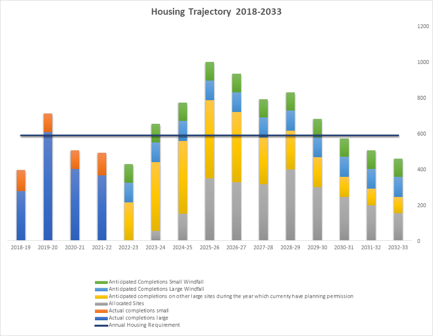
Housing Trajectory
|
LDP Year |
1 |
2 |
3 |
4 |
5 |
6 |
7 |
8 |
9 |
10 |
11 |
12 |
13 |
14 |
15 |
|
|
A |
Year |
2018-19 |
2019-20 |
2020-21 |
2021-22 |
2022-23 |
2023-24 |
2024-25 |
2025-26 |
2026-27 |
2027-28 |
2028-29 |
2029-30 |
2030-31 |
2031-32 |
2032-33 |
|
B |
Remaining years at year end |
15 |
14 |
13 |
12 |
11 |
10 |
9 |
8 |
7 |
6 |
5 |
4 |
3 |
2 |
1 |
|
C |
LDP Housing Requirement (8,822) |
8,822 |
8,822 |
8,822 |
8,822 |
8,822 |
8,822 |
8,822 |
8,822 |
8,822 |
8,822 |
8,822 |
8,822 |
8,822 |
8,822 |
8,822 |
|
D |
Actual recorded completions on large sites during year |
277 |
607 |
399 |
365 |
0 |
0 |
0 |
0 |
0 |
0 |
0 |
0 |
0 |
0 |
0 |
|
E |
Actual recorded completions on small sites during year |
117 |
103 |
104 |
125 |
0 |
0 |
0 |
0 |
0 |
0 |
0 |
0 |
0 |
0 |
0 |
|
F |
Anticipated completions on LDP allocated sites during year |
0 |
0 |
0 |
0 |
0 |
55 |
151 |
348 |
326 |
314 |
398 |
297 |
244 |
197 |
152 |
|
G |
Anticipated completions on other large sites during the year which currenty have planning permission |
0 |
0 |
0 |
0 |
212 |
382 |
406 |
435 |
391 |
261 |
215 |
168 |
112 |
92 |
91 |
|
H |
Anticipated completions windfall during the year |
0 |
0 |
0 |
0 |
112.2 |
112.2 |
112.2 |
112.2 |
112.2 |
112.2 |
112.2 |
112.2 |
112.2 |
112.2 |
112.2 |
|
I |
Anticipated completions small sites during year |
0 |
0 |
0 |
0 |
102.36 |
102.36 |
102.36 |
102.36 |
102.36 |
102.36 |
102.36 |
102.36 |
102.36 |
102.36 |
102.36 |
|
Total completions |
394.0 |
710.0 |
503.0 |
490.0 |
426.6 |
651.6 |
771.6 |
997.6 |
931.6 |
789.6 |
827.6 |
679.6 |
570.6 |
503.6 |
457.6 |
|
|
J |
Total annual completions (D+E+F+G+H+I) minus annual flexibility allowance (10%) |
354.6 |
639.0 |
452.7 |
441.0 |
383.9 |
586.4 |
694.4 |
897.8 |
838.4 |
710.6 |
744.8 |
611.6 |
513.5 |
453.2 |
411.8 |
|
K |
Total cumulative completions |
394.0 |
1104.0 |
1607.0 |
2097.0 |
2523.6 |
3175.1 |
3946.7 |
4944.2 |
5875.8 |
6665.4 |
7492.9 |
8172.5 |
8743.0 |
9246.6 |
9704.2 |
|
L |
Residual housing requirement (C-K) |
8428.0 |
7718.0 |
7215.0 |
6725.0 |
6298.4 |
5646.9 |
4875.3 |
3877.8 |
2946.2 |
2156.6 |
1329.1 |
649.5 |
79.0 |
-424.6 |
-882.2 |
|
M |
5 Year requirement (L/B*5) |
2809.3 |
2756.4 |
2775.0 |
2802.1 |
2862.9 |
2823.4 |
2708.5 |
2423.6 |
2104.4 |
1797.2 |
1329.1 |
811.9 |
131.6 |
-1061.5 |
-4410.8 |
|
AAR adjustment for the last five years of the Plan (589) see manual |
1238.5 |
1257.0 |
1342.4 |
1473.8 |
||||||||||||
|
N |
Total Annual Building Requirement (M/5) |
561.9 |
551.3 |
555.0 |
560.4 |
572.6 |
564.7 |
541.7 |
484.7 |
420.9 |
359.4 |
265.8 |
247.7 |
251.4 |
268.5 |
294.8 |
|
O |
Land available - large sites with planning permission |
594.0 |
1000.0 |
1435.0 |
1826.0 |
1875.0 |
1708.0 |
1470.0 |
1147.0 |
848.0 |
678.0 |
463.0 |
295.0 |
183.0 |
91.0 |
0.0 |
|
P |
Land available - allocations |
55.0 |
206.0 |
554.0 |
880.0 |
1194.0 |
1537.0 |
1683.0 |
1579.0 |
1450.0 |
1288.0 |
890.0 |
593.0 |
349.0 |
152.0 |
0.0 |
|
Q |
Land available - large windfall |
224.4 |
336.6 |
448.8 |
561.0 |
561.0 |
561.0 |
438.3 |
438.3 |
438.3 |
438.3 |
438.3 |
438.3 |
438.3 |
438.3 |
438.3 |
|
R |
Land available - small windfall |
204.7 |
307.1 |
409.4 |
511.8 |
641.0 |
641.0 |
641.0 |
641.0 |
641.0 |
641.0 |
641.0 |
641.0 |
641.0 |
641.0 |
641.0 |
|
S |
Total land available for the five year period (O+P+Q+R) |
1078.1 |
1849.7 |
2847.2 |
3778.8 |
4271.0 |
4447.0 |
4232.3 |
3805.3 |
3377.3 |
3045.3 |
2432.3 |
1967.3 |
1611.3 |
1322.3 |
1079.3 |
|
T |
Housing land supply in years (S/N) |
1.9 |
3.4 |
5.1 |
6.7 |
7.5 |
7.9 |
7.8 |
7.9 |
8.0 |
8.5 |
9.2 |
7.9 |
6.4 |
4.9 |
3.7 |
Spatial Distribution of Housing
|
Components of Housing Supply |
Tier 1 |
Tier 2 |
Tier 3 |
Tier 4 |
No Tier |
|
|
A |
Total completions (small and large) |
1187 |
622 |
236 |
46 |
6 |
|
B |
Units under construction * |
26 |
37 |
32 |
0 |
0 |
|
C |
Units with planning permission** |
2420 |
1586 |
336 |
0 |
0 |
|
D |
New housing allocations |
1498 |
602 |
382 |
0 |
0 |
|
E |
Large windfall sites (+5) |
514 |
402.4 |
317.6 |
0 |
0 |
|
F |
Small windfall sites (-5) |
469 |
367.2 |
289.8 |
0 |
0 |
|
G |
Total Housing Provision |
6088 |
3579.6 |
1561.4 |
46 |
6 |
* Large sites only as of April 2022
** Large sites only as of October 2022