Matters Arising Changes 2026
3. Schedule of Matters Arising Changes (MAC)
MAC 001
Action Point / Reason
AP1/1
To ensure the content of the Plan reflects the actions arising from the Examination
Matters Arising Changes
Insert the following text after paragraph 4.23 and Figure 4: Swansea Bay City Deal.
New Paragraph Numbers
Future Wales: National Plan 2040
Future Wales: National Plan 2040 is set in the context of a vision that will help deliver sustainable places across Wales by 2040, by supporting placemaking and ensuring that development is directed to the right places, making the best use of resources, creating and sustaining accessible healthy communities, protecting our environment and supporting prosperity for all. The Revised LDP aligns with the provisions of Future Wales and its 11 outcomes (as set out in Chapter 3 of Future Wales) and supports its role in driving sustainable growth and combating climate change by guiding strategic development over the next 20 years.
The policies and provisions of the Revised LDP form the framework for implementing and delivering the vision and its strategic objectives, as well as the corporate and strategic priorities of the Council. These policies and provisions include the embedding of sustainable development principles in the Revised LDP, ensuring it makes a positive contribution towards aligning with the content of Future Wales. Consequently, it supports the delivery of the 11 outcomes including sustainable growth, sustainable management of natural resources and reduced pollution, the Welsh language, biodiverse and connected ecosystems and vibrant rural places with access to homes, jobs and services etc.
There are various provisions in Future Wales that directly relate to Carmarthenshire, with Llanelli and Ammanford/Cross Hands falling within the broadly defined Swansea Bay National Growth Areas. Policy 28 of Future Wales identifies the Swansea Bay and Llanelli National Growth Area (NGA) as an area that, will be the main focus for growth and investment in the South West Region. The LDP recognises this as a focus for growth and investment through the identification of its settlements within the top tier of the settlement hierarchy.
Similarly, Carmarthen is identified as a Regional Growth Centre and Newcastle Emlyn forms part of the mid-Wales Regional Growth Area in accordance with (Policy 25).
Future Wales makes provision for managed growth in these area which relates to their important sub-regional functions and strong links across the South West Wales region. It also identifies the need: for the management of natural resources, flooding and the protection and enhancement of areas of environmental and landscape importance and that they should inform strategic decisions on locations for growth and new infrastructure; decarbonising society and responding to the threats of the climate emergency should be central to all regional planning; and recognises the potential Carmarthenshire has of this location for new renewable and low carbon energy-related development, innovation and investment.
The role of placemaking flows through national planning policy and the Revised LDP embeds it as a central component within it. Future Wales, as part of this agenda, also sets out a number of strategic placemaking principles, including enabling urban areas to support ecosystem resilience as well as increasing the population density of towns and cities which are intended to create sustainable and socially inclusive places.
MAC 002
Action Point / Reason
AP1/2
To ensure the content of the Plan reflects the actions arising from the Examination
Matters Arising Changes
Insert the following text after the change proposed above in response to AP1/1.
New Paragraph Numbers
Strategic Development Plans (SDP)
The SDP for the South West Region is defined by the administrative area of the Corporate Joint Committee (CJC) and set out in Future Wales. Formally constituted in January 2022, the CJC for South West Wales was created through the provisions of the Local Government and Elections (Wales) Act 2021. The Committee is made up of representation from Carmarthenshire Council, Neath Port Talbot Council, Pembrokeshire Council and Swansea Council, as well as the Bannau Brycheiniog National Park Authority and the Pembrokeshire Coast National Park Authority.
The Committee has a pivotal strategic role within the region in improving regional planning, the coordination and delivery of transport, land use planning, economic development and energy. This role reflects the wider focus on regional working and collaboration across what is a diverse region, consisting of extensive rural areas and urban areas, all of which are set in and around some of Wales’s most important natural and built historic environments.
Future Wales requires SDPs to accord with the requirements of Policy 19. In this respect, they must consider and respond to the national sustainable placemaking outcomes set out in Future Wales which, in combination, seek to create a more sustainable, healthy, equitable and fairer Wales. SDPs will be expected to demonstrate how the spatial framework they develop, and the key choices they make, will contribute to delivering the Outcomes. The future role of SDPs and the relationship with the Revised LDP has been a consideration in the development of this Plan, with regional collaboration as an important component. In this regard, specific reference is made to the spatial definition of the NGA prepared jointly by the authorities across the region. This has been used to inform the provisions of the Revised LDP and will form part of the evidence for the forthcoming SDP. It demonstrates the aligning of the spatial strategies and settlement hierarchies of the Revised LDP and the SDP with the provisions of Future Wales and its outcomes.
Carmarthenshire has, and will continue to, work collaboratively with authorities across the South West Wales region, and those within the mid Wales region, on the future provisions and content of the SDP. Whilst the SDP is in its initial stages, the Council has worked proactively with neighbouring authorities on the governance arrangements and formative requirements for its preparation. The Council has also developed shared evidence which will support the preparation and delivery of the Revised LDP and will help to inform and underpin the content of a future SDP. This includes evidence in relation to Development Viability, Local Housing Market Assessments, Population and Household projections, the Swansea Bay and Llanelli National Growth Area Definition Project, Two County Economic Study for Carmarthenshire and Pembrokeshire, and the South West Wales Stage 1 Strategic Flood Consequence Assessment.
MAC 003
Action Point / Reason
AP1/3
To ensure the content of the Plan reflects the actions arising from the Examination
Matters Arising Changes
Amend Strategic Objective SO4 as follows:
SO4 To ensure that the principles of equal opportunities and social inclusion are upheld by promoting access to a high quality and diverse mix of housing, public services, healthcare, shops, leisure facilities and work opportunities, as well as vibrant town centres.
MAC 004
Action Point / Reason
AP2/1
To ensure the content of the Plan reflects the actions arising from the Examination
Matters Arising Changes
Amend Policy SP1 to reflect the change in housing numbers as set out under MAC 011. As well as including cross reference to Policy SP3.
Strategic Policy – SP1: Strategic Growth
The LDP will provide for the future growth of a sustainable economy and housing requirement through the provision of:
- 9,814 new homes to meet the identified housing requirement of 8,822.
- A minimum of 71.21ha of allocated employment land.
The focus on regeneration and growth reflects the Council's core strategic ambitions with development distributed in a sustainable manner consistent with the spatial strategy and settlement framework (Policy SP3).
MAC 005
Action Point / Reason
AP1/6, AP15/7
To ensure the content of the Plan reflects the actions arising from the Examination
Matters Arising Changes
Amend Policy SG1 to explain the proposed use and quantum of development.
SG1: Regeneration and Mixed-Use Sites
|
Site Ref. |
Location and Proposed Uses |
|
PrC1/MU1 |
West Carmarthen, Carmarthen Mix of uses proposed consisting of residential (an allowance for 700 new homes within this plan period), employment, community facilities (including a primary school) and amenity. A key deliverability indicator is the Carmarthen West Link Road which is now completed and open. |
|
PrC1/MU2 |
Pibwrlwyd, Carmarthen Includes a mix of uses reflecting its strategic location and contribution to Carmarthen. Uses include employment, commercial leisure, education associated with Coleg Sir Gâr and residential (an allowance is made for 247 new homes). |
|
PrC2/MU1 |
Former Old Castle Works, Llanelli Mix of uses focused on the visitor economy, heritage and leisure, and associated infrastructure and landscaping across the 3.4ha site, including the renovation of the Grade 2 Listed Building known as the Tinhouse (750sqm). The site is previously developed land and part of a regeneration proposal consisting of less vulnerable uses. The site is within immediate proximity to the Millennium Coastal Park. No residential allowance has been made. |
|
PrC2/MU2 |
Trostre Gateway, Llanelli Mix of uses including the development of a Class A1 Food store and a Drive-Thru Coffee Shop, with associated access, car parking and landscaping which has been developed in the early years of the Revised LDP plan period. A small parcel of land remains on the western side which would support a small-scale retail led use of approximately 250m² gross floor space. reflecting its prominent location and planning history. |
|
PrC2/MU3 |
Former YMCA Building, Stepney Street, Llanelli Town Centre
The site has been completed and comprises office / retail spaces on the ground floor. 8 residential units having been completed on the upper floors of the development. |
|
PrC3/MU1 |
Emlyn Brickworks, Penygroes Provides for the regeneration of a previously developed site. |
|
SeC4/MU1 |
Burry Port Waterfront
The mixed-use allocation is split into two separate areas of land. The northern element of the allocation includes the potential for a mix of uses focused on appropriate retail provision of up to 2,000m² gross floor space, along with commercial / tourism related uses. Any proposed development will need to consider the Plan’s policies along with the provisions of TAN4. The southern part of the site is part of the Burry Port Masterplan area (Site 4). The site has outline planning permission for commercial leisure development comprising of a mix of retail, hotel, pub/restaurant and residential uses of up to 5,000m² gross floor space. No residential allowance has however been made within Policy HOM1 – Housing Allocations. |
|
SeC16/MU1 |
Beechwood, Llandeilo The site includes |
|
SeC20/MU1 |
Laugharne Holiday Park The site consists of a mix of uses focused on tourism and leisure |
|
PrC1/MU3 |
Nant y Caws Regeneration and Mixed-Use Site A strategically positioned site already utilised for the sustainable management of waste. It offers the future opportunity to potentially harness energy, and related employment-based activities. The consolidation of future opportunities on the site will be set out through the development of a masterplan. |
New paragraph after para 11.16
New paragraph number: Reference is made to Policy CCH4 to ensure that there is no adverse effect on the integrity of nutrient sensitive protected sites.
MAC 006
Action Point / Reason
AP1/7
To ensure the content of the Plan reflects the actions arising from the Examination
Matters Arising Changes
Delete Policy SG2 - Reserve Sites and its reasoned justification from the Plan, with consequential amendments to Policy SG3 – Pembrey Peninsula taking its place as the new Policy SG2.
In addition, all other subsequent cross referencing amended accordingly throughout the Plan.
MAC 007
Action Point / Reason
AP1/13; AP4/14; AP15/7
To ensure the content of the Plan reflects the actions arising from the Examination
Matters Arising Changes
Amend Policy SP2 as follows:
Strategic Policy – SP 2: Retail and Town Centres
Proposals for retail and other town centre use development will be considered in accordance with the following retail hierarchy and the provisions below:
|
Sub Regional - High Order Town Centre |
Carmarthen |
|
Mid Order Town Centres |
Llanelli Ammanford |
|
Lower Order Town Centres |
Burry Port Llandeilo Llandovery Newcastle Emlyn St. Clears Whitland |
- Proposals for retail and other appropriate town centre uses within the Carmarthen town centre boundary (including leisure, civic, cultural, education, business (including B1(a) offices), health and residential (on upper floors)) which support the growth of Carmarthen as a sub-regional retail town centre will be permitted where they maintain and enhance the vitality, viability and attractiveness of Carmarthen Town Centre. Proposals should not:
- undermine the retail function of the centre, or have a detrimental effect upon the vitality or viability of the area; and
- create a concentration of non-retail ground floor frontage detrimental to the retail character and function of the area.
- The vitality, viability and attractiveness of
ourthe retail centres will be maintained and enhanced along with the range of their existing uses, including local markets. Proposals within the town centre boundaries, which widen the range of uses and encourage convenient and accessible shopping, services, public services and facilities, and employment/business opportunities will be supported.
c) Proposals for convenience stores outside of the defined town centre boundary will be subject to:
The submission of an impact assessment to demonstrate that the proposal would not have an adverse effect on the vitality and viability of the existing retail centre;Evidence of a sequential test having been applied to the site selection;Evidence of quantitative and qualitative need for the development; and,Evidence of the site’s accessibility to sustainable modes of transport.
dc) Proposals for retail and other town centre uses within the town centre boundary will be supported which, where applicable:
- Provide opportunities for independent retail and commercial sectors;
- Support
and do not underminethe continued retail function of the high and mid order town centres; - Promote and diversify the education, leisure, cultural facilities, and the night-time economy;
- Provide for the creation of quality public spaces and environmental improvements including the preservation and enhancement of the distinctive local character of the historic built and natural environment, and a commitment to high quality design;
- Improve places for pedestrians, cyclists and people with health conditions or impairments including enhancing public transport, accessibility, access to public facilities and conveniences, car parking, signage, and the street scene; and,
- Protect, enhance, and integrate with the Green and Blue Infrastructure network.
d) Outside of the above town centre boundaries the following forms of retail provision and other town centre uses may be permitted in accordance with national policy:
- New non-food retail warehouse units (including garden centres, car showrooms and ancillary supporting facilities), appropriate leisure facilities on designated retail parks and trade centre uses on employment sites, where they are supported by
therelevant evidence.noted below:an impact assessment demonstrating that the proposal would not cause harm to established town centres;evidence that a sequential approach has been undertaken indicating that there are no suitable available and sustainable sites in locations within or immediately adjoining defined town centres;evidence of quantitative, qualitative and/or other relevant need for the development;evidence of the site’s accessibility to sustainable modes of transport.
- Proposals for small local convenience shopping facilities in rural and urban areas within the development limits where they are of a scale appropriate to that settlement. Rural retail proposals will be considered in accordance with policy RTC2.
Amend paragraph 11.34 as follows:
11.34Carmarthen has a longstanding sub-regional role and has traditionally had a strong national presence on its high street as well as a variety of local stores. The nature of its retail offer has however been notably impacted by Covid-19 with a number of national operators having withdrawn in light of the financial challenges and realignment within the retail sector. Consequently, whilst the centre does and will continue to serve a range of needs for the population beyond its local community the nature of its offer and the range of uses within the traditional retail core must be adaptive whilst retaining that traditional retail base. The Policy therefore allows the flexibility to introduce uses other than retail into the town centre. In doing so, criterion a seeks to ensure that a mix of uses are not detrimental to the town centre’s retail character and function. Proposals should not result in the over-concentration of non-retail units in Carmarthen Town Centre. Each proposal will be considered on its own merits considering its context and surrounding uses. The biannual Town Centre Retail Audit records the uses of each unit within the town centre boundary and will be used to inform the consideration of applications. The audit will enable the identification of clusters of non-retail use of units and monitor long term trends of vacant properties. The centre continues to be readily characterised as a higher order retail centre by the provisions above.
Insert new paragraph after 11.40:
New paragraph number
The Retail Study indicates that there is no capacity for additional comparison goods retail floorspace in Carmarthenshire over the Plan period, and that proposals for additional comparison floorspace will therefore need to demonstrate that there is a need for the additional provision. Similarly, the Retail Study indicates that there is an oversupply of convenience floorspace in Carmarthenshire, however, this varies across the County and the Study suggests that there is some capacity for additional convenience floorspace in Zone 1 – Carmarthen and Zone 3 – Ammanford Cross Hands, as identified in the Study. Notwithstanding this, proposals for convenience floorspace will need to demonstrate that there is a retail need for additional convenience floorspace in accordance with Technical Advice Note 4 Retail and Commercial Development (2016).
Amend paragraph 11.43 as follows to define small local convenience stores:
Provision outside the sub-regional and mid order centres, including local village shops, make an important contribution to the retail function of Carmarthenshire. In this respect, those centres fulfilling a convenience retail need and smaller scale day to day shopping need provide diversity consistent with the objectives of sustaining communities and minimising the need to travel. These settlements and their retail offer can complement the established retail function of those higher up the hierarchy as well as contributing to the implementation of the Plan’s Strategy. Proposals for convenience retail outside of the town centre boundary in such centres may be required to appropriately evidence the retail need to ensure the retailing activities within the town centres are not undermined. Their scale should be appropriate and proportionate to the relative settlement but generally should not exceed 200 square metres gross of floorspace. Proposals which exceed this threshold should demonstrate that there is a need for the level of retail floorspace identified.
New paragraph to be inserted after para 11.55
New paragraph: Reference is made to Policy CCH4 to ensure that there is no adverse effect on the integrity of nutrient sensitive protected sites
MAC 008
Action Point / Reason
AP1/14
To ensure the content of the Plan reflects the actions arising from the Examination
Matters Arising Changes
Amend Policy RTC1 as follows:
RTC1: Protection of Local Shops and Facilities
Proposals which would result in the loss of a local shop, service or community facility (including Public Houses) outside of the Town Centres identified within Strategic Policy SP2 will only be permitted where:
- Its loss would not be detrimental to the social and economic fabric of the community;
- There is another shop or service of a similar compatible use
available for customerswithin the settlement or within a convenient walking distance.
In the absence of an alternative provision, proposals resulting in the loss of the local shop, or service will only be permitted where all reasonable attempts have been made to marketit can be demonstrated that the business for sale or let has been marketed for over a continuous 12 month period and have failed.
MAC 009
Action Point / Reason
AP15/7
To ensure the content of the Plan reflects the actions arising from the Examination
Matters Arising Changes
To ensure the appropriate reference is had to the provisions of Policy CCH4 it is proposed to add the following sentence to the reasoned justification of Policy RTC2 after para 11.66
New paragraph number: Reference is made to Policy CCH4 to ensure that there is no adverse effect on the integrity of nutrient sensitive protected sites.
MAC 010
Action Point / Reason
AP1/8
AP15/7
To ensure the content of the Plan reflects the actions arising from the Examination
Matters Arising Changes
Amend policy SD1 as follows:
SD1: Development Limits
Development Llimits are defined on the proposals map for those settlements identified as Principal Centres, Service Centres and Sustainable Villages within Strategic Policy SP3.
Proposals within defined Ddevelopment Llimits will be permitted, subject to policies and proposals of this Plan, national policies, and other material planning considerations. In rural settlements and outside defined development limits there will be a presumption against inappropriate development.
New Paragraph Number: Development limits are a key mechanism for helping to manage future growth by defining the area within which development would normally be permitted, subject to material planning considerations. The development limits have been applied to the Principal Centres, Service Centres and Sustainable Villages as defined in Strategic Policy SP3: Sustainable Distribution – Settlement Framework.
11.75In preparing this Plan, development limits have been defined across all settlements within Tiers 1, 2, and 3, in order to:
- Prevent inappropriate development in the countryside and provide certainty and clarity as to where exceptions proposals (adjacent to limits) may be considered appropriate;
- Prevent coalescence of settlements (or separate parts of the same settlement), unacceptable ribbon development or a fragmented development;
- Identify those areas within which development proposals would be permitted (see above); and,
- Promote effective and appropriate use of land concentrating growth within defined settlements.
New Paragraph Number: In rural settlements (Tier 4) and outside the defined development limits proposals for development will be strictly controlled and will only be supported in accordance with Plan policies, and/or if a countryside location is deemed essential given the nature of the proposal, in-line with National Planning Policy and Guidance.
New Paragraph Number: The presumption against any inappropriate proposals outside defined settlement boundaries provides clarity as to the appropriate locations for future development and will ensure growth is strategically managed. The consideration of potentially appropriate housing beyond settlement boundaries will be undertaken having regard to the policies of the plan (specific reference should be had to AHOM2) and National Planning Policy and Guidance.
New Paragraph Number: National Planning Policy and Guidance and the policies of this Plan recognise that local employment opportunities within rural settlements are important to sustain and improve communities. Reference is made to Policy EME 4 which makes provision for appropriate employment proposals outside the development limits, as well as EME2 in relation to the expansion of existing rural enterprises. In line with National Planning Policy it recognises that small-scale enterprises have a vital role to play in the rural economy and contribute to both local and national competitiveness and prosperity. In this respect many commercial and light manufacturing activities can be appropriately located in rural areas without causing unacceptable disturbance or other adverse effects allowing for diversification of the rural economy. This is particularly relevant to the County’s rural areas where the Plan supports rural employment and enterprises.
11.76 Not all land on a Proposals Map and Inset Maps is identified for a particular development, or the subject of a specific policy. Significant areas of land can appear as unannotated land in the Plan. Proposals for development will be considered on their individual merits against the provisions of this LDP, and other material considerations.
New paragraph number: Reference is made to Policy CCH4 to ensure that there is no adverse effect on the integrity of nutrient sensitive protected sites.
MAC 011
Action Point / Reason
AP2/1
To ensure the content of the Plan reflects the actions arising from the Examination
Matters Arising Changes
Amend first paragraph of Policy SP4 as follows:
In order to ensure the overall housing requirement of 8,822 homes for the plan period is met, provision is made for 9,7049,814 new homes in accordance with the settlement framework (Policy SP3) in order to promote the creation and enhancement of sustainable communities.
Consequential amendment to para 9.57, first bullet point:
- Provide for
9,7049,814 new homes to deliver a housing requirement of 8,822 homes;
MAC 012
Action Point / Reason
AP2/1
To ensure the content of the Plan reflects the actions arising from the Examination
Matters Arising Changes
Amend paragraph 11.79 as follows:
11.79This Plan factors in a number of housing supply components to meet this housing need, together with flexibility (uplift) to ensure that the overall aim of the strategic policy to provide new homes is met. The housing supply provides a flexibility allowance of 11.24% The housing supply and is made up of the following components:
Housing Allocations (5+ homes)o Land bank Commitmentso Completed DwellingsWindfall Allowanceo Small Site Component (less than 5 homes)o Windfall Component (5+ Homes)Flexibility (+10%)
|
Policy HOM1 allocations |
2685 |
|
Commitments (Remaining) |
2750 |
|
Large Windfall (Remaining) |
522 |
|
Small Windfall (Remaining) |
840 |
|
Completions: |
|
|
Commitments (Completed) |
2269 |
|
Large Windfall (Completed) |
84 |
|
Small Windfall (Completed) |
664 |
|
Total |
9814 |
Consequential changes to Paragraph 9.11:
9.11In delivering the number of homes set out above, this Preferred Strategy includes an additional flexibility as part of its supply (uplift) to ensure the delivery of sustainable growth and to overcome any potential unforeseen deliverability issues. A 11.24% 10% flexibility allowance through a further 992 882 homes, is included. This equates to a housing supply of 9,814 9,704 dwellings to deliver the 8,822 homes.
Consequential changes to the monitoring framework:
|
LDP and ISA Objectives |
Policy |
Indicator Ref: |
Monitoring Indicator |
Target |
Trigger Point |
Source |
|
SO6, SO10 ISA10, ISA15 |
SP4 HOM1 |
MI. 8 |
Local Indicator: Number of dwellings delivered on Housing Allocations. |
To deliver |
The overall number of new housing units built on allocated sites which fall below the annual requirement for 2 consecutive years |
Carmarthenshire County Council |
MAC 013
Action Point / Reason
AP2/4
AP15/7
AP6/21
To ensure the content of the Plan reflects the actions arising from the Examination 1/17
Matters Arising Changes
Amend HOM1 table as follows (note that the site references will be subject to minor editorial change to ensure consistent and consecutive numbering reflecting the deletion of sites identified as commitments and the inclusion of additional sites) as well the reasoned justification.
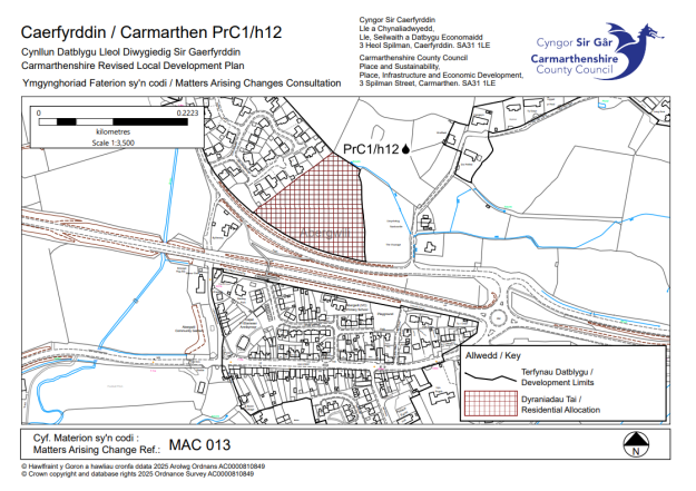
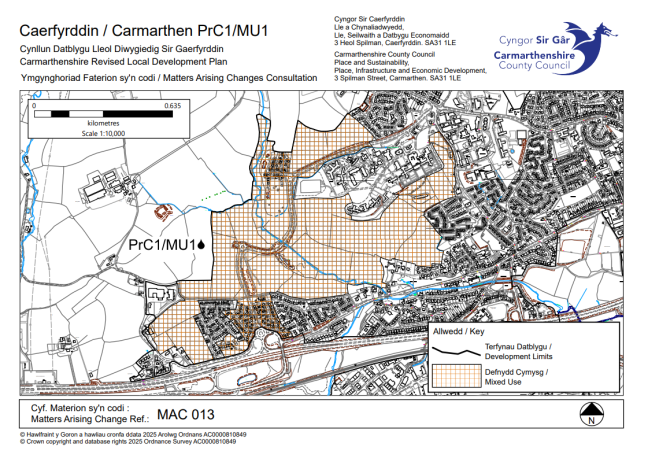
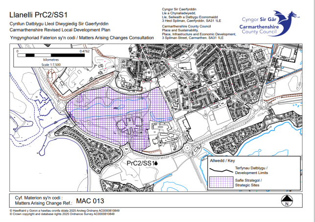
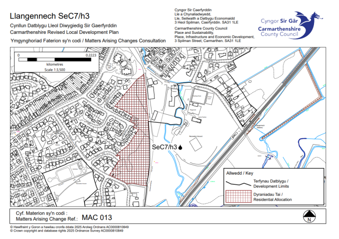
Include annotation (💧) to identify the following sites which have an element of flood risk.
PrC1/h12 💧 - Castell Pigyn Road, Abergwili
PrC1/MU1 💧 - West Carmarthen
PrC2/SS1💧 - Pentre Awel
SeC7/h3 💧 - Golwg Yr Afon
Consequential amendments to the proposals map as well as the interactive map to include 💧 annotating flood risk next to site reference and to amend interactive map to include reference to flood risk policies.
|
|
|
|
|
|
|
|
|
|||||
|
|
|||||
|
|
|
|
|
|
|
|
|
|
|
|
|
|
|
|
|
|
|
|
|
|
|
|
|
|
|
|
|
|
|
|
|
|
|
|
|
|
|
|
|
|
|
|
|
|
|
|
|
|
|
|
|
|
|
|
|
|
|
|
|
|
|
|
|
|
|
|
|
|
|
|
|
|
|
|
|
|
|
|
|
|
|
|
|
|
|
|
|
|
|
|
|
|
|
|
|
|
|
|
|
|
|
|
|
|
|
|
|
|
|
|
|
|
|
|
|
|
|
|
|
|
|
|
|
|
|
|
|
|
|
|
291 |
|
|
|
|
|
|
|
|
|
|||||
|
|
|
|
|
|
|
|
|
|
|
|
|
|
|
|
|
|
|
|
|
|
|
|
|
|
|
|
|
|
|
|
|
|
|
|
|
|
|
|
|
|
|
|
|||||
|
|
|
|
|
|
|
|
|
|
|
|
|
|
|
|
|||||
|
|
|
|
|
|
|
|
|
|
|
|
|
|
|
|
|||||
|
|
|
|
|
|
|
|
|
|||||
|
|
|
|
|
|
|
|
|
|||||
|
|
|
|
|
|
|
|
|
|||||
|
|
|
|
|
|
|
|
|
|||||
|
|
|
|
|
|
|
|
|
|
|
|
|
|
|
|
|||||
|
|
|
|
|
|
|
|
|
|||||
|
|
|
|
|
|
|
|
|
|
|
|
|
|
|
|
|||||
|
|
|
|
|
|
|
|
|
|||||
|
|
|
|
|
|
|
|
|
|||||
|
|
|
|
|
|
|
|
|
|||||
|
|
|
|
|
|
|
|
|
|||||
|
|
|
|
|
|
|
|
|
|||||
|
|
|
|
|
|
|
|
|
|
|
|
|
|
|
|
|||||
|
|
|
|
|
|
|
|
|
|
||||
|
|
|||||
|
|
|||||
|
|
|
|
|
|
|
|
|
|
|
|
|
|
|
|
|
|
|
|
|
|
|
|
|
|
|
|
|
|
|
|
|
|
|
|
|
|
|
|
|
|
|
|
|
|
|
|
|
|
|
|
|
|
|
|
|
|
|
|
|
|
|
|
|
|
|
|
|
|
|
|
|
|
|
|
|
|
|
|
|
|
|
|
|
|
|
|
|
|
|
|
|
|
|
|
|
|
|
|
|
|
|
|
|
|
|
|
|
|
|
|
|
|
|
|
|
|
|
|
|
|
|
|
|
|
|
|
|
|
|
|
|
|
|
|
|
|
|
|
|
|
|
|
|
|
|
|
|
|
|
|
|
|
|
|
|
|
|
|
|
|
|
|
|
|
|
|
|
|
|
|
|
|
|
|
|
|
|
|
|
|
|
|
|||||
|
|
|
|
|
|
|
|
|
|
|
|
|
|
|
|
|
|
|
|
|
|
|
|||||
|
|
|
|
|
|
|
|
|
|
|
|
|
|
|
|
|
|
|
|
|
|
|
|||||
|
|
|
|
|
|
|
|
|
|
|
|
|
|
|
|
|||||
|
|
|
|
|
|
|
|
|
|
|
|
|
|
|
|
|
|
|
|
|
|
|
|
|
|
|
|
|
|
|||||
|
|
|
|
|
|
|
|
|
|
|
|
|
|
|
|
|
|
|
|
|
|
|
|
|
|
|
|
|
|
|||||
|
|
|
|
|
|
|
|
|
|
|
|
|
|
|
|
|
|
|
|
|
|
|
|||||
|
|
|
|
|
|
|
|
|
|
|
|
|
|
|
|
|||||
|
|
|
|
|
|
|
|
|
|
|
|
|
|
|
|
|
||||
|
|
|||||
|
|
|||||
|
|
|
|
|
|
|
|
|
|
|
|
|
|
|
|
|
|
|
|
|
|
|
|
|
|
|
|
|
|
|
|
|
|
|
|
|
|
|
|
|
|
|
|
|
|
|
|
|
|
|
|
|
|
|
|
|
|
|||||
|
|
|
|
|
|
|
|
|
|||||
|
|
|
|
|
|
|
|
|
|||||
|
|
|
|
|
|
|
|
|
|
|
|
|
|
|
|
|
|
|
|
|
|
|
|
|
|
|
|
|
|
|||||
|
|
|
|
|
|
|
|
|
|
|
|
|
|
|
|
|
|
|
|
|
|
|
|||||
|
|
|
|
|
|
|
|
|
|||||
|
|
|
|
|
|
|
|
|
|
|
|
|
|
|
|
|
|
|
|
|
|
|
|
|
|
|
|
|
|
|||||
|
|
|
|
|
|
|
|
|
|
|
|
|
|
|
|
|
|
|
|
|
|
|
|
|
|
|
|
|
|
|
|
|
|
|
|
|
|
|
|
|
|
|
|
|||||
|
|
|
|
|
|
|
|
|
|
|
|
|
|
|
|
|||||
|
|
|
|
|
|
|
|
|
|
|
|
|
|
|
|
|||||
|
|
|
|
|
|
|
|
|
|
|
|
|
|
|
|
|||||
|
|
|
|
|
|
|
|
|
|||||
|
|
|
|
|
|
|
|
|
|
|
|
|
|
|
|
|||||
|
|
|
|
|
|
|
|
|
|
|
|
|
|
|
|
|||||
|
|
|
|
|
|
|
|
|
|||||
|
|
|
|
|
|
|
|
|
|||||
|
|
|
|
|
|
|
|
|
|||||
|
|
|
|
|
|
|
|
|
|||||
|
|
|
|
|
|
|
|
|
|
||||
|
|
|||||
|
|
|||||
|
|
|
|
|
|
|
|
|
|
|
|
|
|
|
|
|
|
|
|
|
|
|
|||||
|
|
|
|
|
|
|
|
|
|
|
|
|
|
|
|
|||||
|
|
|
|
|
|
|
|
|
|
|
|
|
|
|
|
|||||
|
|
|
|
|
|
|
|
|
|||||
|
|
|
|
|
|
|
|
|
|||||
|
|
|
|
|
|
|
|
|
|||||
|
|
|
|
|
|
|
|
|
|
|
|
|
|
|
|
|||||
|
|
|
|
|
|
|
|
|
|
|
|
|
|
|
|
|||||
|
|
|
|
|
|
|
|
|
|||||
|
|
|
|
|
|
|
|
|
|||||
|
|
|
|
|
|
|
|
|
|||||
|
|
|
|
|
|
|
|
|
|
||||
|
|
|||||
|
|
|||||
|
|
|
|
|
|
|
|
|
|
|
|
|
|
|
|
|||||
|
|
|
|
|
|
|
|
|
|||||
|
|
|
|
|
|
|
|
|
|
|
|
|
|
|
|
|
|
|
|
|
|
|
|||||
|
|
|
|
|
|
|
|
|
|||||
|
|
|
|
|
|
|
|
|
|
||||
|
|
|||||
|
|
|||||
|
|
|
|
|
|
|
|
|
|
|
|
|
|
|
|
|
|
|
|
|
|
|
|
|
|
|
|
|
|
|
|
|
|
|
|
|
|
|
|
|
|
|
|
|
|
|
|
|
|
|
|
|
|
|
|
|
|
|
|
|
|
|
|
|
|||||
|
|
|
|
|
|
|
|
|
|
|
|
|
|
|
|
|
|
|
|
|
|
|
|
|
|
|
|
|
|
|||||
|
|
|
|
|
|
|
|
|
|
|
|
|
|
|
|
|
|
|
|
|
|
|
|||||
|
|
|
|
|
|
|
|
|
|
|
|
|
|
|
|
|||||
|
|
|
|
|
|
|
|
|
|||||
|
|
|
|
|
|
|
|
|
|
|
|
|
|
|
|
|||||
|
|
|
|
|
|
|
|
|
|
|
|
|
|
|
|
|||||
|
|
|
|
|
|
|
|
|
|||||
|
|
|
|
|
|
|
|
|
|||||
|
|
|
|
|
|
|
|
|
|
||||
|
Site Ref |
Site Name |
Total units in Plan Period |
Total Affordable Units in Plan period |
Delivery Timescale |
Units beyond the Plan Period |
|
Cluster 1 |
|||||
|
Carmarthen |
|||||
|
PrC1/h4 |
Land off Parc y Delyn |
17 |
1.7 |
Year 11 15 |
|
|
PrC1/h5 |
East of Devereaux Drive |
10 |
1 |
Year 6 - 10 |
|
|
PrC1/h8 |
*Llansteffan Road |
50 |
50 |
Year 6 - 10 |
|
|
PrC1/h10 |
Brynhyfryd |
20 |
2.4 |
Year 6 - 10 |
|
|
PrC1/h12 |
Castell Pigyn Road, Abergwili 💧 |
35 |
4.2 |
Year 6 - 10 |
|
|
PrC1/MU1 |
West Carmarthen 💧 |
222 |
26.64 |
Year 1 - 5 |
291 |
|
PrC1/MU2 |
Pibwrlwyd |
247 |
61.75 |
Year 11 - 15 |
|
|
PrC1/(iv) |
Land off Trevaughan Road |
30 |
3.6 |
Year 11 - 16 |
|
|
Pontyates / Meinciau / Ponthenri |
|||||
|
SeC1/h4 |
Cae Canfas, Heol Llanelli |
8 |
Commuted Sum Contribution |
Year 6 - 10 |
|
|
SeC1/h7 |
Land off Heol Glyndwr |
9 |
2 |
Year 6 - 10 |
|
|
Ferryside |
|||||
|
SeC2/h2 |
Land to the rear of Parc y Ffynnon |
12 |
1.2 |
Year 6 - 10 |
|
|
Cynwyl Elfed |
|||||
|
SuV1/h1 |
Adjacent Fron Heulog |
2 |
Commuted Sum Contribution |
Year 1 - 5 |
|
|
SuV1/h2 |
Land adj. Lleine |
13 |
1.3 |
Year 6 - 10 |
|
|
Bronwydd |
|||||
|
SuV4/h1 |
Land at Troed Rhiw Farm |
6 |
Commuted Sum Contribution |
Year 6 - 10 |
|
|
Peniel |
|||||
|
SuV10/h2 |
Aberdeuddwr / Pantyfedwen |
38 |
4.56 |
Year 6 - 10 |
|
|
Alltwalis |
|||||
|
SuV11/h1 |
*Land at Alltwalis School |
12 |
12 |
Year 6 - 10 |
|
|
Llanpumsaint |
|||||
|
SuV12/h1 |
Adj. Gwyn Villa |
20 |
2.4 |
Year 6 - 10 |
|
|
SuV12/h2 |
Llandre |
4 |
Commuted Sum Contribution |
Year 1 - 5 |
|
|
Rhydargaeau |
|||||
|
SuV14/h1 |
Cefn Farm |
17 |
1.7 |
Year 1 - 5 |
|
|
Capel Dewi |
|||||
|
SuV16/h1 |
Llwynddewi Road |
2 |
Commuted Sum Contributions |
Year 1 - 5 |
|
|
Nantgaredig |
|||||
|
SuV17/h1 |
Rear of former joinery, Station Road |
35 |
4.2 |
Year 6 - 10 |
|
|
Llanddarog |
|||||
|
SuV19/h2 |
Land adj. and the r/o Haulfan |
10 |
1 |
Year 6 - 10 |
|
|
Porthyrhyd |
|||||
|
SuV20/h1 |
Land adjacent to Llwynhenry Farm |
6 |
Commuted Sum Contribution |
||
|
Cluster 1 Total |
825 |
291 |
|||
|
Cluster 2 |
|||||
|
Llanelli |
|||||
|
PrC2/h1 |
Beech Grove, Pwll |
10 |
1 |
Year 6 - 10 |
|
|
PrC2/h10 |
Land adjacent The Dell, Furnace |
13 |
1.3 |
Year 6 - 10 |
|
|
PrC2/h20 |
*Harddfan |
6 |
6 |
Year 6 - 10 |
|
|
PrC2/h23 |
Dafen East Gateway |
150 |
37.5 |
Year 6 - 10 |
|
|
PrC2/SS1 |
Pentre Awel 💧 |
240 |
60 |
Year 6 - 10 |
|
|
PrC2/(iii) |
Land off Pendderi Road, Bryn |
35 |
4.2 |
Year 6 - 10 |
|
|
PrC2/(v) |
Land off Heol y Mynydd, Bryn |
80 |
16 |
Year 6 - 10 |
|
|
Kidwelly |
|||||
|
SeC3/h2 |
Land off Priory Street |
20 |
2.4 |
Year 11 - 15 |
|
|
Hendy / Fforest |
|||||
|
SeC6/h2 |
Land between Clayton Road and East of Bronallt Road |
12 |
1.2 |
Year 1 - 5 |
|
|
SeC6/(ii) |
Fforest Garage |
8 |
Commuted Sum Contribution |
Year 6 - 10 |
|
|
SeC6/(iii) |
Land at Fforest Road |
35 |
4.2 |
Year 1 - 5 |
|
|
Llangennech |
|||||
|
SeC7/h3 |
Golwg Yr Afon 💧 |
50 |
25 |
Year 6 - 10 |
|
|
SeC7/h4 |
Opposite Parc Morlais |
32 |
3.84 |
Year 6 - 10 |
|
|
SeC7/h5 |
*Maesydderwen |
5 |
5 |
Year 6 - 10 |
|
|
SeC7/(i) |
Land at Pontarddulais Road |
60 |
12 |
Year 6 - 10 |
|
|
Mynyddygarreg |
|||||
|
SuV22/h2 |
Land adjacent to Ty Newydd, Meinciau Road |
8 |
Commuted Sum Contribution |
Year 6 - 10 |
|
|
Five Roads / Horeb |
|||||
|
SuV23/h2 |
Adjacent Little Croft |
25 |
3 |
year 11 - 15 |
|
|
Cluster 2 Total |
789 |
||||
|
Cluster 3 |
|||||
|
Ammanford (inc Betws and Penybanc) |
|||||
|
PrC3/h1 |
Land at r/o No 16-20 &; 24-30 Betws Road |
9 |
Commuted Sum Contribution |
Year 11 - 15 |
|
|
PrC3/h6 |
Land Adjoining Maes Ifan, Maesquarre Road |
18 |
1.8 |
Year 6 - 10 |
|
|
PrC3/(iv) |
Land adjoining Maes Ifan, Maesquarre Road |
6 |
1.08 |
Year 6 - 10 |
|
|
PrC3/(v) |
Land off Parklands Road |
9 |
Commuted Sum Contribution |
Year 6 - 10 |
|
|
Cefneithin |
|||||
|
PrC3/h8 |
Land off Heol y Parc |
18 |
1.8 |
Year 6 - 10 |
|
|
Drefach (Tumble) |
|||||
|
PrC3/h14 |
*Nantydderwen |
33 |
33 |
Year 6 - 10 |
|
|
Gorslas |
|||||
|
PrC3/h18 |
Land adjoining Brynlluan |
29 |
3.48 |
Year 11 - 15 |
|
|
PrC3/(ix) |
Breakers Yard |
80 |
16 |
Year 6 - 10 |
|
|
Llandybie |
|||||
|
PrC3/h20 |
Land north of Maespiode |
45 |
5.4 |
Year 6 - 10 |
|
|
Penygroes |
|||||
|
PrC3/MU1 |
Emlyn Brickworks |
107 |
33.75 |
Year 11 - 15 |
|
|
PrC3/(i) |
Emlyn Brickworks |
50 |
6 |
Year 11 - 15 |
|
|
PrC3/(ii) |
Land opposite 112-116 Heol Waterloo |
11 |
1.1 |
Year 11 - 15 |
|
|
PrC3/(viii) |
Land r/o 108-114 Waterloo Road |
6 |
Commuted Sum Contribution |
Year 6 - 10 |
|
|
Saron |
|||||
|
PrC3/h26 |
Land off Parc-y-Mynydd |
15 |
1.5 |
Year 6 - 10 |
|
|
PrC3/h27 |
Land off Nant-y-Ci Road |
18 |
1.8 |
Year 11 - 15 |
|
|
Tumble |
|||||
|
PrC3/h28 |
Land at Factory site between No. 22 &; 28 Bethesda Road |
30 |
3.6 |
Year 6 - 10 |
|
|
Brynamman |
|||||
|
SeC9/h2 |
Heol Gelynen |
8 |
8 |
Year 11 - 15 |
|
|
Pontyberem / Bancffosfelen |
|||||
|
SeC11/h1 |
Land off Heol Llannon |
15 |
1.5 |
Year 11- 15 |
|
|
Carmel |
|||||
|
SuV27/h1 |
Land adjacent to Tŷ Newydd |
5 |
Commuted Sum Contribution |
Year 6 - 10 |
|
|
Ystradowen |
|||||
|
SuV30/h1 |
Land off Pant y Brwyn |
5 |
5 |
Year 6 - 10 |
|
|
Cluster 3 Total |
517 |
||||
|
Cluster 4 |
|||||
|
Newcastle Emlyn |
|||||
|
SeC12/h1 |
Trem y Ddol |
17 |
1.7 |
Year 6 - 10 |
|
|
SeC12/h3 |
Land to r/o Dolcoed |
20 |
3.4 |
Year 6 - 10 |
|
|
Llanybydder |
|||||
|
SeC13/h1 |
Adj. Y Neuadd |
10 |
1 |
Year 6 - 10 |
|
|
Pencader |
|||||
|
SeC14/h1 |
Blossom Garage |
20 |
2.4 |
Year 6 - 10 |
|
|
SeC14/h2 |
Land adj Maescader |
24 |
2.88 |
Year 6 - 10 |
|
|
Llangeler |
|||||
|
SuV33/h1 |
Land opp Brogeler |
5 |
Commuted Sum Contribution |
Year 6 - 10 |
|
|
Saron/Rhos |
|||||
|
SuV35/h1 |
Land adj. Arwynfa |
6 |
Commuted Sum Contribution |
Year 6 - 10 |
|
|
Llanllwni |
|||||
|
SuV36/h1 |
Cae Pensarn Helen |
6 |
Commuted Sum Contribution |
Year 6 - 10 |
|
|
SuV36/h2 |
*Land at Bryndulais |
16 |
16 |
Year 6 - 10 |
|
|
Cwmann |
|||||
|
SuV37/h2 |
Land south of Cae Coedmor |
20 |
2.4 |
Year 6 - 10 |
|
|
SuV37/h3 |
Land adjacent to Lleinau |
10 |
1 |
Year 6 - 10 |
|
|
Capel Iwan |
|||||
|
SuV38/h1 |
Maes y Bryn |
6 |
Commuted Sum Contribution |
Year 6 - 10 |
|
|
Llanfihangel ar arth |
|||||
|
SuV39/h1 |
Adj Yr Hendre |
7 |
Commuted Sum Contribution |
Year 6 - 10 |
|
|
New Inn |
|||||
|
SuV43/h1 |
Blossom Inn |
5 |
Commuted Sum Contribution |
Year 1 - 5 |
|
|
Cluster 4 Total |
172 |
||||
|
Cluster 5 |
|||||
|
Llandovery |
|||||
|
SeC15/h2 |
Land adjacent to Bryndeilog, Tywi Avenue |
8 |
Commuted Sum Contribution |
Year 11 - 15 |
|
|
Llandeilo |
|||||
|
SeC16/h1 |
Llandeilo Northern Quarter |
27 |
3.24 |
Year 6 - 10 |
|
|
Llangadog |
|||||
|
SeC17/h1 |
Land opp. Llangadog C.P School |
16 |
1.6 |
Year 6 - 10 |
|
|
SeC17/h2 |
Land off Heol Pendref |
8 |
Commuted Sum Contribution |
Year 6 - 10 |
|
|
Cwmifor |
|||||
|
SuV51/h1 |
Opp. Village Hall |
8 |
Commuted Sum Contribution |
Year 11 - 15 |
|
|
Cluster 5 Total |
67 |
||||
|
Cluster 6 |
|||||
|
St Clears / Pwll Trap |
|||||
|
SeC18/h1 |
Adjacent to Brittania Terrace |
60 |
12 |
Year 11- 15 |
|
|
SeC18/h3 |
Land adjacent to Cefn Maes |
100 |
20 |
Year 6 - 10 |
|
|
SeC18/h4 |
Land at Heol Llaindelyn |
6 |
Commuted Sum Contribution |
Year 6 - 10 |
|
|
SeC18/h5 |
Land adjacent to Gwynfa, Station Road |
8 |
Commuted Sum Contribution |
Year 6 - 10 |
|
|
SeC18/h6 |
Land to the rear of Station Road |
25 |
3 |
Year 11- 15 |
|
|
Whitland |
|||||
|
SeC19/h1 |
Land at Park View, Trevaughan |
8 |
Commuted Sum Contribution |
Year 6 - 10 |
|
|
SeC19/h2 |
Land at Whitland Creamery |
20 |
2.4 |
Year 6 - 10 |
|
|
Laugharne |
|||||
|
SeC20/h3 |
Land off Clifton Street |
6 |
Commuted Sum Contribution |
Year 11- 15 |
|
|
Glandy Cross |
|||||
|
SuV55/h2 |
Land to the north of Cross Inn P.H |
6 |
Commuted Sum Contribution |
Year 6 - 10 |
|
|
Efailwen |
|||||
|
SuV56/h1 |
Land to the r/o Talar Wen |
6 |
Commuted Sum Contribution |
Year 6 - 10 |
|
|
Meidrim |
|||||
|
SuV58/h1 |
*Land adj. to Lon Dewi |
10 |
10 |
Year 6 - 10 |
|
|
SuV58/h2 |
Land off Drefach Road |
14 |
1.4 |
Year 6 - 10 |
|
|
Bancyfelin |
|||||
|
SuV59/h2 |
North of Maes y Llewod |
19 |
1.9 |
Year 6 - 10 |
|
|
SuV59/(i) |
North East of Bancyfelin School |
16 |
16 |
Year 6 - 10 |
|
|
Llangynog |
|||||
|
SuV60/h1 |
Land at College Bach |
6 |
Commuted Sum Contribution |
Year 6 - 10 |
|
|
Pendine |
|||||
|
SuV61/h1 |
Land at Nieuport Farm |
5 |
1 |
Year 6 - 10 |
|
|
Cluster 6 Total |
315 |
||||
Include new paragraph after para 11.87:
New paragraph number: Reference is made to Policy CCH4 to ensure that there is no adverse effect on the integrity of nutrient sensitive protected sites.
Proposals map amended to include annotation for sites that are subject to flood risk:
MAC 014
Action Point / Reason
AP2/7
AP15/7
To ensure the content of the Plan reflects the actions arising from the Examination
Matters Arising Changes
Amend policy HOM2 as follows:
HOM2: Housing within Development Limits
Proposals for housing developments on unallocated sites within the development limits of a defined settlement in Tiers 1, 2 and 3 of the Settlement Framework (Policy SP3) will be permitted, provided they are in accordance with the principles of the Plan’s strategy, policies and proposals.
11.88Sites capable of accommodating five or more dwellings feature as allocated housing sites in the Plan (refer to Policy HOM1). However, within the development limits of defined settlements there may be opportunities for development on unallocated sites. Within the settlement hierarchy, land that has not been allocated is referred to as a windfall site in relation to housing development. Proposals should reflect the character of the area and be compatible with the provisions of the Plan and, in particular, the principles of sustainable development and placemaking set out in Policy PSD1.
New paragraph after para 11.88:
New paragraph number: Reference is made to Policy CCH4 to ensure that there is no adverse effect on the integrity of nutrient sensitive protected sites.
MAC 015
Action Point / Reason
AP2/8;
AP15/7
To ensure the content of the Plan reflects the actions arising from the Examination
Matters Arising Changes
Amend Policy HOM3 to the following
HOM3: Homes in Rural Villages
In those settlements identified as rural villages under Policy SP3, proposals for small scale developments of 1 to 4 dwellings will be permitted provided that: will be permitted for the following:
- The scale and design of the proposed development is appropriate to the scale, form and character of the settlement, taking into account the cumulative impact of incremental development; and
- The scale and nature of the development will maintain or enhance the vitality of the rural community within the settlement; and
- The proposed development consists of, and represents a:
- minor infill of a small gap between the existing built form; or
- logical extensions and/or rounding off, of the development pattern where they adjoin the boundary of one property which forms part of the rural village group. All proposals which adjoin a group (as opposed to infill sites) will be required to demonstrate the following:
- there is an existing physical or visual feature which provides a boundary for the group - reducing pressure for unacceptable ribbon development or rural sprawl; or
- where such a feature does not exist, there should be potential for such a feature to be provided so long as it is in character with the scale and appearance of the group; or
- Conversion or the sub-division of large dwellings.
Proposals will not be permitted where:
- they are in open fields adjoining a group which have no physical features to provide containment; and / or
- they are located beyond clear physical features which form strong boundaries for a group (e.g. main roads, substantial tree belts, rivers etc.)
Proposals for more than 4 dwellings will not be considered appropriate except where they relate to 100% affordable housing schemes and strictly accord with the policy criteria listed above.
minor infill of a small gap between the existing built form; or,logical extensions and/or rounding off of the development pattern that fits in with the character of the village form and landscape; orconversion or the sub-division of large dwellings.
Such proposals will be subject to other detailed planning considerations set out within LDP policies.
Reference made to the guidance on acceptable plots in the County’s rural villages (see below).
Proposals which exceed the 10% cap above the number of existing homes in the settlement, as at the LDP base date, will not be permitted except where they conform to Policy AHOM1 in relation to the provision of affordable homes.
11.89The settlement framework for the Plan area identified in Strategic Policy SP3 recognises and reflects the area’s diversity and that of its communities. In identifying the Rural Villages, the Plan seeks to make provision for those settlements which make an important contribution within their community and offer opportunities for small scale and appropriate new homes within rural settings.
11.90This part of the Plan’s rural policy framework seeks to establish a flexible but controlled approach to the delivery of new homes within those settlements. The Plan utilises a criteria-based assessment to define small scale housing opportunities in rural villages and to meet the need for new homes in rural parts of Carmarthenshire at a scale and at locations which maintain the essential character of the countryside. Where settlements defined within the policy come under significant pressure from the cumulative impact of housing development, the Council will prepare a capacity assessment to determine any potential for further rural housing growth within that settlement.
11.91In order to reflect the rural character and to prevent unacceptable and potentially detrimental levels of growth, a cap of 10% over and above the number of existing homes, as of the base date of the Plan in the settlement will be allowed.
11.92Further guidance in the form of SPG will be published to support the interpretation and application of the above and the policy. The guidance will form part of a suite of SPG to support with the design and siting considerations in general and will enable proposals to effectively integrate with and contribute to the development of cohesive and sustainable communities.
New paragraph number: Reference is made to Policy CCH4 to ensure that there is no adverse effect on the integrity of nutrient sensitive protected sites.
Guidance on Acceptable Plots
Infill sites within these rural villages will take priority over other locations;Where appropriate, sites adjoining a rural village are also acceptable. Such sites will be required to adjoin the boundary of one property which forms part of the rural village group. All proposals which adjoin a group (as opposed to infill sites) will be required to demonstrate the following:there is an existing physical or visual feature which provides a boundary for the group - reducing pressure for unacceptable ribbon development or rural sprawl;where such a feature does not exist, there should be potential for such a feature to be provided so long as it is in character with the scale and appearance of the group;
Proposals located in open fields adjoining a group, which have no physical features to provide containment will not be considered acceptable; 4. Proposals which are located beyond clear physical features which form strong boundaries for a group (e.g. main roads, substantial tree belts, rivers etc.) will not be considered acceptableProposals which are located beyond clear physical features which form strong boundaries for a group (e.g. main roads, substantial tree belts, rivers etc.) will not be considered acceptable
MAC 016
Action Point / Reason
AP15/7
To ensure the content of the Plan reflects the actions arising from the Examination
Matters Arising Changes
To amend policy the reasoned justification of HOM4, to ensure the appropriate reference is had to the provisions of Policy CCH4. New paragraph after para 11.97:
New paragraph number: Reference is made to Policy CCH4 to ensure that there is no adverse effect on the integrity of nutrient sensitive protected sites.
MAC 017
Action Point / Reason
AP15/7
To ensure the content of the Plan reflects the actions arising from the Examination
Matters Arising Changes
To amend policy the reasoned justification of HOM5, to ensure the appropriate reference is had to the provisions of Policy CCH4. New paragraph after para 11.101:
New paragraph number: Reference is made to Policy CCH4 to ensure that there is no adverse effect on the integrity of nutrient sensitive protected sites.
MAC 018
Action Point / Reason
AP2/10 AP15/7
To ensure the content of the Plan reflects the actions arising from the Examination
Matters Arising Changes
Amend policy HOM6 as follows:
HOM6: Specialist Housing
Proposals for new care home developments and extensions to established specialist housing facilities will be permitted within or adjoining the development limits of defined existing settlements (Policy SP3) where:
- It reflects the needs of the proposed occupants in respect of their safe and convenient access to shops, services, community facilities and public transport or active travel routes; and,
- It provides a suitable and appropriate quality, design, and type of accommodation as well as the level of support and care for the intended occupiers
Proposals for specialist housing outside and not adjoining the defined development limits will only be permitted if it can be demonstrated that they are needed, viable and sustainable and where:
- It is ancillary to an existing care home and not disproportionate to it in scale; or,
- It represents the appropriate conversion of an existing property, which is suitable to the needs of the proposed occupants and accords with both criterion a) and b) above.
New paragraph to be added after para 11.103:
New paragraph number: Reference is made to Policy CCH4 to ensure that there is no adverse effect on the integrity of nutrient sensitive protected sites.
MAC 019
Action Point / Reason
AP15/7
To ensure the content of the Plan reflects the actions arising from the Examination
Matters Arising Changes
Amend Policy HOM7 as follows:
HOM7: Renovation of Derelict or Abandoned Dwellings
Proposals for the renovation of derelict or abandoned dwellings outside the Development Limits of a defined settlement (Policy SP3) will be permitted where:
a) It can be demonstrated that a significant part of the original structure is physically sound and substantially intact requiring only a limited amount of structural remedial works;
b) The building demonstrates and retains sufficient quality of architectural features and traditional materials with no significant loss of the character and integrity of the original structure;
c) There are no adverse effects on the setting or integrity of the historic environment.
In exceptional instances where it can be demonstrated that the original dwelling played a recognised and significant role in the history, culture, and development of Carmarthenshire, the use of photographic or documentary evidence may be accepted as a means to illustrate the original details of the dwelling.
New paragraph to be added after para 11.105:
New paragraph number: Reference is made to Policy CCH4 to ensure that there is no adverse effect on the integrity of nutrient sensitive protected sites.
MAC 020
Action Point / Reason
AP15/7
To ensure the content of the Plan reflects the actions arising from the Examination
Matters Arising Changes
Amend Policy HOM8 as follows:
HOM8: Residential Caravans
Proposals for temporary residential caravans will be permitted where:
a) The caravan is required to house an essential worker, in agriculture, forestry or other appropriate employment undertaking who must live on site rather than in a nearby settlement; or,
b) The caravan is required in conjunction with the construction of a single dwelling on a self-build plot, or during the construction of a replacement dwelling; and,
c) The caravan or mobile home will be located close to other buildings where possible and will not cause significant access, parking, infrastructural or amenity problems; and,
d) They will not have an unacceptable adverse impact on wider landscape or nature conservation objectives.
New paragraph to be added after para 11.106:
New paragraph number: Reference is made to Policy CCH4 to ensure that there is no adverse effect on the integrity of nutrient sensitive protected sites.
MAC 021
Action Point / Reason
AP15/7
To ensure the content of the Plan reflects the actions arising from the Examination
Matters Arising Changes
To amend policy the reasoned justification of HOM9, to ensure the appropriate reference is had to the provisions of Policy CCH4. New paragraph after para 11.111:
New paragraph number: Reference is made to Policy CCH4 to ensure that there is no adverse effect on the integrity of nutrient sensitive protected sites.
MAC 022
Action Point / Reason
AP3/1
To ensure the content of the Plan reflects the actions arising from the Examination
Matters Arising Changes
Amend Policy SP5 and its supporting reasoned justification to the following:
Strategic Policy – SP 5: Affordable Homes Strategy
The Plan will maximise the delivery of affordable homes up to 2033 through the provision of a minimum target of 2,111 1,900affordable homes. This will support the development and enhancement of sustainable, balanced communities.
11.116 Whilst the LDP and planning system seeks to support the delivery of affordable homes, it is only one of few mechanisms used to meet this need. This is reflected in the Council’s Affordable Housing Delivery Plan which sets out a five-year vision for delivering affordable housing. The LDP’s contribution to the target is set out in SP5 through:
- On-site provision of affordable housing as a percentage of the overall development, or on sites acquired by social housing providers;
- Off-site affordable housing in lieu of on-site provision;
- Commuted sum contributions to support the delivery of affordable housing; and
- Local Need housing.
New paragraph Number: In combining all methods of affordable housing contributions through the planning system the target set out in Policy SP5 is the starting point for the provision of Affordable Housing within the county, with the Plan seeking to maximise the provision where applicable.
11.117 Reference is also made to the Carmarthenshire Rural Needs Study 2019 which identifies a higher proportion of larger dwellings within the rural areas that contribute to higher house prices52. The LDP looks to support the growth of more affordable units within the rural communities to promote development for first time buyers or those in low-income households.
MAC 023
Action Point / Reason
AP3/2 AP15/7
To ensure the content of the Plan reflects the actions arising from the Examination
Matters Arising Changes
Amendment to Policy AHOM1:
AHOM1: Provision of Affordable Homes
On-site Contributions
An on-site contribution towards affordable housing will be required on all market housing allocations and windfall sites of 10 or more homes to meet the affordable housing target set out in Policy SP5. The percentage target level for affordable housing is based on the scale of development:
a) sites comprising 10 – 19 homes will be required to provide an affordable housing contribution of 10%;
b) sites comprising 20 - 50 homes will be required to provide an affordable housing contribution of 12%;
c) sites comprising 51 – 100 homes will be required to provide an affordable housing contribution of 20%;
d) sites of 101 homes or more will be required to provide an affordable housing contribution of 25%.
The affordable housing target percentage noted is a target to be used as a starting point for affordable housing negotiations.
Where adjacent and related residential proposals result in combined numbers meeting or exceeding the above thresholds, the Council will seek an element of affordable housing based on applying the above target percentages to the aggregate number of dwellings.
Proposals will be required to ensure that the dwelling remains affordable for all subsequent occupants in perpetuity.
Commuted Sums
A commuted sum towards affordable housing will be required from proposals comprising 1 – 9 dwellings. Commuted sum charges will be based on floor space (cost per sq.m).
Proposals for single dwellings categorised as 3-bed, 4-person dwellings or smaller, and less than 88 square metres will be exempt.
Where the above requirements cannot be achieved due to their impacts upon a proposal's financial viability, a variation may be agreed on a case-by-case basis.
11.118 Policies AHOM1 and AHOM2 aim to assist the Council to meet its housing need and in particular to deliver the affordable housing need identified in Policy HOM1.
11.119 The policy sets out the affordable housing contributions to be provided. The requirements of the policy reflect the findings of the Revised LDP’s ongoing Viability Study and takes into consideration other factors such as the LHMA, past delivery rates and the need for flexibility to allow for variances between sites.
11.120 The Policy’s requirements for on-site contributions apply to all proposed housing developments located within settlement boundaries with a capacity to deliver a net increase of 10 dwellings or more new homes. Those sites which fall outside of the settlement boundaries will be subject to the requirements of Policy AHOM2.
New paragraph number: The affordable housing target percentage noted within the policy is a target to be used as a starting point for affordable housing negotiations.
New paragraph number: Where adjacent and related residential proposals result in combined numbers meeting or exceeding the above thresholds, the Council will seek an element of affordable housing based on applying the above target percentages to the aggregate number of dwellings.
New paragraph number: Proposals will be required to ensure that the dwelling remains affordable for all subsequent occupants in perpetuity.
11.121 The policy’s requirements for commuted sums apply to all proposed open market proposals resulting in a net increase of 1 – 9 new dwellings, with the exception of single dwellings which are categorised as 3-bed, 4-person homes and not exceeding 88 square metres in internal, habitable floor space.
11.122 The mix of dwelling sizes, types and tenure required to be provided on each site will vary according to the specific needs of the locality at the time of application. This will need to take into consideration the latest information on housing need from the LHMA, alongside any relevant local information such as the Council’s waiting list and any recently delivered affordable housing units within the area.
New paragraph: Reference is made to Policy CCH4 to ensure that there is no adverse effect on the integrity of nutrient sensitive protected sites.
MAC 024
Action Point / Reason
AP3/3 AP15/7
To ensure the content of the Plan reflects the actions arising from the Examination
Matters Arising Changes
Amend Policy AHOM2 as follows:
AHOM2: Affordable Housing- Exceptions Sites
Proposals for 100% affordable housing development on sites adjoining the Ddevelopment Llimits of defined settlements (Tiers 1-3 in Policy SP3), and in those settlements identified as Rural Villages (Tier 4) will, in exceptional circumstancesbe permitted where it is to meet a genuine identified local need (as defined within the Glossary of Terms) and where:
- The site represents a logical extension to the development limits and is of a scale appropriate, and in keeping with the character of the settlement;
- The benefits of the initial affordability will be retained for all subsequent occupants;
- It is of a size, scale and design compatible with an affordable dwelling and available to low or moderate income groups;
- There are no market housing schemes within the settlement, or projected to be available which include a requirement for affordable housing.
New paragraph number: All new affordable local need housing will be restricted to those who can demonstrate they have a need to live in the Town and Community Council area and are in Affordable Housing Need. Reference is drawn to the Glossary of Terms which considers the Local Need Eligibility, and the criteria which must be satisfied to permit local need housing.
11.123 The granting of planning permission will be subject to conditions and planning obligations which ensure the affordable housing remains available to meet future local affordable housing needs.
11.124 An affordable dwelling must be compatible with WG’s Design Quality Requirement standards to limit its size, scale and design to ensure that the dwelling falls within a reasonable and acceptable affordable dwelling cost for future occupants. In exceptional circumstances, a A departure from these standards may be considered appropriate where they are to meet the occupant’s needs and are clearly evidenced and justified.
New paragraph: Reference is made to Policy CCH4 to ensure that there is no adverse effect on the integrity of nutrient sensitive protected sites.
MAC 025
Action Point / Reason
AP4/1
To ensure the content of the Plan reflects the actions arising from the Examination
Matters Arising Changes
Amend Policy SP7 as follows:
Strategic Policy – SP 7: Employment and the Economy
Sufficient lLand has been allocated for the provision of 71.21 hectares of employment provision for the Plan period in accordance with the Plan’s Settlement Framework (Policy SP3) and sustainability principles.
The sustainable approach to the provision of employment land reflects the following:
1)a) The allocation and delivery of:
a)1. Pentre Awel, Llanelli and
b)2. Yr Egin – Creative Digital Cluster, Carmarthen;
2.b) Allocating employment land in sustainable location which accords with the sustainability principles of the Plan;
3.c) Safeguard existing employment sites – recognising their contribution as part of the employment portfolio in meeting ongoing need;
4.d) Supporting small scale sustainable employment developments and enterprises in lower tiered settlements.
5.e) Ensuring support is provided to entrepreneurship as part of the creation of a diverse and growing economy;
6. f) Allow appropriate small scale employment opportunities and rural enterprises in the countryside to support rural communities and to deliver a diverse and sustainable rural economy.
Insert new paragraph relating to Pentre Awel before paragraph 11.140.
In considering the allocation and delivery of employment land within Pentre Awel, not all employment activities relate to B class uses and consequently it does not form part of the 71.21ha of employment land provision set out in Policy SP7.
Deletion of paragraphs 11.142 – 11.145 with the inclusion of the new reasoned justification
11.142 The Council has undertaken evidence gathering to provide an understanding of the future employment need notably around the Welsh Government’s nine priority sectors.56 Further evidence has been prepared in conjunction with Pembrokeshire County Council to establish quantitative analysis of forecast demand for employment sites at the larger than local level. This Two County Study was supplemented by market and employer evidence in relation to market demand. In addition, work has been undertaken in relation to the links between equating the levels of employment land and jobs with the requirement for new homes growth for the County.
11.143 The Two County Study seeks to achieve a balance between fulfilling the requirements of Technical Advice Note 23 on Economic Development (February 2014), whilst placing a strong emphasis on flexibility, realism of sector growth and ability to meet demand at a regional scale.
11.144 TAN 23 considers that ‘land provision targets may be higher than anticipated demand, to allow for the chance to meet demand. The Practice Guidance to the TAN (August 2015) considers that, where justified, land provision targets maybe higher than anticipated demand, to allow for the chance that the assessments are too low and to ensure that no opportunities are missed. In acknowledging the importance of not solely relying on employment forecasts when identifying a portfolio of employment land, the Two County Study emphasises the demand and confidence of indigenous businesses to remain and grow, and a desire by stakeholders to preserve locational advantages and strategic assets for future growth.
11.145 In recognition of the above, the Two County Study has identified a portfolio of sites within the study area which are considered to offer strategic benefits and opportunity for growth and job creation.
Evidence for future employment need
New paragraph numbers
The Council has undertaken evidence gathering to provide an understanding of the future employment need within the County and notably around the Welsh Government’s nine priority sectors. Two pieces of evidence have been produced which include the Housing and Economic Growth Report (November 2022), and a Two Counties Study which has been prepared in conjunction with Pembrokeshire County Council.
Strategic Policy SP7: Employment and the Economy sets the framework to enable the delivery of a balanced level of employment land to accommodate the new jobs and identified need through the Two County Economic Study for Pembrokeshire and Carmarthenshire and the Housing and Economic Growth Report.
The Two County Study established quantitative analysis of forecast demand for employment sites at the larger than local level and was supplemented by market and employer evidence in relation to market demand. The Housing and Economic Growth Report further considered the links between equating the levels of employment land and jobs with the requirement for new homes growth for the County.
The Revised LDP’s background evidence provides the narrative for the relationship between housing growth, job creation and employment land provision. In extrapolating data from the demographical modelling, it suggests that the preferred scenario of 8,822 dwellings could accommodate 276 new jobs per year, which would not support fully the Experian forecast of 354 jobs per year. To achieve this, it would require a more pronounced labour force behavioural change within the County; however, the Plan seeks to consider several factors in determining a level of sustainable growth.
The WG’s Practice Guidance - Building an Economic Development Evidence Base to Support a Local Development Plan considers that where justified, land provision targets may be higher than anticipated demand, to allow for the chance that the assessments are too low and to ensure that no opportunities are missed. They should also allow for flexibility, competition, and choice. However, persistent oversupply of employment land may cause harm where the planned land supply exceeds demand, so that allocated employment sites remain vacant for long periods and frustrate development for other land uses.
The Revised LDP allocates 71.21 hectares of employment land which could provide an estimated 6,652 jobs, and whilst it is recognised that the homes to jobs calculation, and job creation to employment land provision does not align with the Revised LDP it must be noted that there is not an exact and direct relationship between housing and jobs, and thus any relationship can only be read as indicative.
It is also important to note that the level of new homes must be deliverable and evidenced. In this regard any increase in new homes to correspond with the potential jobs created through new employment allocations would result in an undeliverable over-provision of new housing within the County.
Nevertheless, the Housing and Economic Growth Report assessed the patterns of commuting from the 2011 Census which identified a commuting ratio of 1.09, indicating a net outflow of commuters from Carmarthenshire. The Plan, through the allocation of 71.21ha, seeks to re-balance the commuting ratio to reduce the outflow of Carmarthenshire’s residents to work and to promote investment and sustainable forms of growth within the County.
The scale of employment land identified within the Plan ensures flexibility and deliverability and reflects the analysis set out within the Two County Study and the Housing and Economic Growth Report. Its importance is to support the investment and ambition of Carmarthenshire’s strategic regeneration plan and other economic growth strategies as well as the Swansea Bay City Deal and South West Wales Regional Economic Delivery Report.
MAC 026
Action Point / Reason
AP4/3
To ensure the content of the Plan reflects the actions arising from the Examination
Matters Arising Changes
EME1: Employment- Safeguarding of Employment Sites
Sites identified for employment purposes through policy SP7 and existing employment sites will be safeguarded for such uses (B1, B2, B8 and those identified through relevant policy provisions).
Exceptionally, pProposals which result in their loss will only be permitted where it can be demonstrated that:
a.a) The site or premises is no longer required or suitable for employment use;
b.b) The proposed use could not reasonably be located elsewhere in accordance with the policies of this Plan;
c.c) There is sufficient quantity, quality and variety of employment land or premises that can be brought forward to meet the employment needs of the County and the local area;
d.d) There are no economically viable industrial or business employment uses for the site and premises;
e.e) An employment use is incompatible with adjoining/surrounding uses; and
f.f) Where applicable the proposed uses are complimentary to the primary employment use of the surrounding area and will not cause an unacceptable impact on the operations of existing businesses.
Amend paragraph 11.153 as follows:
11.153 This policy seeks to ensure that existing employment sites are protected from alternative (non-B class) uses. In order to maintain an adequate supply of employment land which provides for a range and choice of potential uses, this policy seeks to protect defined employment areas from non-employment uses which should be in better and potentially more appropriate locations. A schedule of existing employment sites is provided in Appendix 12 and shown on the Proposals Map. Proposals for alternative (non-B) uses will need to justify why the site or premises is no longer required (for economic reasons) or suitable (become inappropriate for the location) for employment use. In terms of economic reasons, in the absence of an alternative provision, proposals resulting in the loss of an employment use will only be permitted where it can be demonstrated that business uses are no longer viable at the site. This must include evidence to show that appropriate and reasonable efforts have been made to market the site for sale or lease for its existing, or similar, employment use. The type of information must include the following:
- The length of time the site or property has been vacant; and,
- A Marketing Strategy detailing the type of use which the site/property has been marketed for and its duration – there must be a minimum of 12 months appropriate marketing; and
- The amount of interest in the site during the marketing period, including the type and number of queries, together with the reason(s) for the ultimate lack of take-up/interest.
Insert new paragraph before 11.154.
New paragraph: Where a proposal seeks a change of use to B1(a) office use on a safeguarded employment site, reference to the town centre first approach as set out in national policy should be considered. Particular regard should be had to Policy 6: Town Centre First as set out in Future Wales: the National Plan 2040, and paragraph 4.3.18 of PPW which relates to the sequential approach when determining planning applications for retail and B1 uses.
11.154 In recognition of the pressures on employment areas from alternative uses (non-Class B), the policy accepts that some flexibility may in some instances be required. Such uses are often partial B class uses combining a small-scale retail element with predominantly business, industrial or storage use, or are sui generis. It is also accepted that in meeting the needs of such uses, employment areas are often likely to be more acceptable than other locations such as residential areas, or even town centres. Any retail element will be expected to be ancillary to the primary use, and for trade purposes as opposed to the public.
MAC 027
Action Point / Reason
AP4/4, AP15/7
To ensure the content of the Plan reflects the actions arising from the Examination
Matters Arising Changes
Amend Policy EME2 as follows
EME2: Employment – Extensions and Intensification
Proposals for extensions (of existing employment buildings) and/or intensification of existing employment enterprises will be permitted provided that:
a) a. The development proposals are will not likely to cause environmental damage or prejudice other redevelopment proposals;
b) b.The proposal does not extend and/or intensify a use or activity that might result in adverse amenity issues, or may not be compatible, with neighbouring uses; and
c) c. The development proposals are is of an appropriate scale and form compatible with its location.
Proposals for the expansion of existing rural enterprises will be supported subject to the above provisions and the policies and proposals of this Plan.
Amend paragraph 11.157 as follows
11.157 This policy relates to extensions to existing buildings and/or the intensification of uses on existing employment enterprises, in both rural and urban locations. The intensification of existing employment enterprises may include the small-scale extension of the existing site, and which may include new buildings associated with the extension, if these are considered necessary to the operation. However, Pproposals which seek to extend and/or intensify a use or activity will not be favourably considered if they are not compatible with surrounding uses, or likely to result in adverse amenity issues which would prejudice other redevelopment proposals.
New paragraph to be included after para 11.159
New paragraph: Reference is made to Policy CCH4 to ensure that there is no adverse effect on the integrity of nutrient sensitive protected sites.
MAC 028
Action Point / Reason
AP4/2, AP15/7
To ensure the content of the Plan reflects the actions arising from the Examination
Matters Arising Changes
Amend Policy EME3 as follows, with the subsequent deletion of paragraph 11.161 of the reasoned justification and a new column added to table 7 which indicates the amount of committed employment land.
EME3: Employment Proposals on Allocated Sites
Proposals for B1, B2 and B8 employment development will be permitted on the following allocated employment sites where they comply with the proposed use of the site.
Other employment and related ancillary non-B class uses will be permitted on allocated employment sites where it can be demonstrated the proposed development complements and enhances the site’s role as identified in the Employment Site Allocation table below. Consideration must be given to the amenity and the safe operation of adjacent employment uses to avoid conflict between different land uses.
|
Site Ref: |
Site Name: |
Location: |
Use Class: |
Total Area (Ha): |
Amount Committed (Ha): |
|
PrC1/E1 |
Cillefwr Industrial Estate |
Carmarthen |
B1, B2, B8 |
4.167 |
0.56 |
|
PrC1/E1 (i) |
Land west of Cillefwr Road West |
2 |
0 |
||
|
PrC1/E1 (ii) |
Land north of Alltycnap Road |
1.215 |
0 |
||
|
PrC1/E1 (iii) |
Land south of Alltycnap Road |
0.952 |
0.56 |
||
|
PrC1/MU1 |
West Carmarthen |
Carmarthen |
B1, B2, B8 |
4.53 |
0 |
|
PrC1/MU2 |
Pibwrlwyd |
Carmarthen |
B1,B2, B8 |
8.95 |
2.33 |
|
PrC1/SS1 |
Yr Egin |
Carmarthen |
B2 |
1.04 |
1.04 |
|
PrC2/E2 |
Dafen |
Llanelli |
B1,B2,B8 |
17.489 |
1.9 |
|
PrC2/E2 (i) |
Land east of Calsonic |
4.723 |
0 |
||
|
PrC2/E2 (ii) |
Land west of Gestamp Tallent |
1.547 |
0 |
||
|
PrC2/E2 (iii) |
Land at Heol Aur |
1.657 |
0 |
||
|
PrC2/E2(iv) |
Land west of Heol Gors |
1.449 |
0 |
||
|
PrC2/E2 (v) |
Land at Heol Croppin |
0.355 |
0 |
||
|
PrC2/E2 (vi) |
Land west of the Beacon |
1.881 |
1.9 |
||
|
PrC2/E2 (vii) |
Land east of Air ambulance Base |
1.316 |
0 |
||
|
PrC2/E2 (viii) |
Land at Llanelli Gate, off Heol Aur |
3.755 |
0 |
||
|
PrC2/E2 (ix) |
Land west of Llys Aur |
0.806 |
0 |
||
|
PrC3/E1 |
Cross Hands East |
Ammanford / Cross Hands |
B1,B8 |
8.31 |
8.31 |
|
PrC3/E2 |
Cross Hands West Food Park |
Ammanford / Cross Hands |
B1,B2,B8 |
5.647 |
0 |
|
PrC3/E2(i) |
Land west of Castell Howell |
1 |
0 |
||
|
PrC3/E2(ii) |
Land south of Heol Parc Mawr |
2.712 |
0 |
||
|
PrC3/E2(iii) |
Land north of Dunbia |
1.935 |
0 |
||
|
PrC3/E3 |
Cross Hands Business Park |
Ammanford / Cross Hands |
B1,B2,B8 |
4.76 |
0 |
|
PrC3/E3 (i) |
Heol Stanllyd (West) |
2 |
0 |
||
|
PrC3/E3 (ii) |
Heol Stanllyd (South) |
2.156 |
0 |
||
|
PrC3/E3 (iii) |
Heol Stanllyd (East) |
0.604 |
0 |
||
|
PrC3/E6 |
Capel Hendre Industrial Estate |
Ammanford / Cross Hands |
B1,B2,B8 |
0.538 |
0.44 |
|
PrC3/E7 |
Parc Hendre, Capel Hendre1 |
Ammanford / Cross Hands |
B1,B2,B8 |
8.112 |
0.77 |
|
PrC3/E7(i) |
Parc Hendre (West) |
2.165 |
0 |
||
|
PrC3/E7(ii) |
Parc Hendre (North) |
1.955 |
0 |
||
|
PrC3/E7(iii) |
Parc Hendre (East) |
1.05 |
0.77 |
||
|
PrC3/E7(iv) |
Parc Hendre (South) |
2.942 |
0 |
||
|
PrC3/E8 |
Cilyrychen Industrial Estate |
Cilyrychen |
B1,B2,B8 |
0.751 |
0 |
|
SeC4/E1 |
Dyfatty |
Burry Port |
B1,B2,B8 |
3.036 |
3.036 |
|
SeC16/E1 |
Beechwood Industrial Estate |
Llandeilo / Rhosmaen |
B1,B2,B8 |
0.289 |
0.25 |
|
SeC16/MU1 |
Beechwood |
Llandeilo / Rhosmaen |
B1,B2,B8 |
0.755 |
0 |
|
SeC16/E2 |
Former Market Hall |
Llandeilo |
B1 |
0.2 |
0.2 |
|
SeC18/E1 |
St Clears Business Park |
St Clears |
B1,B8 |
0.421 |
0 |
|
SeC19/E1 |
Whitland Industrial Estate |
Whitland |
B1,B8 |
0.489 |
0 |
|
SeC19/E2 |
Land South of Former Creamery |
Whitland |
B1,B2,B8 |
1.321 |
0 |
|
SeC13/E1 |
Old Foundry |
Llanybydder |
B1,B8 |
0.405 |
0.405 |
|
Total |
71.21 |
19.24 |
|||
Table 7: Employment Proposals on Allocated Sites
11.160 The total figure in the above table includes notional figures for B use employment on Mixed Use sites (Policy SG1) and Strategic sites (Policy SP6). The Table identifies committed land within each site (source: Employment Land Review, 2023).
New paragraph to be included after para 11.162:
New paragraph number: Reference is made to Policy CCH4 to ensure that there is no adverse effect on the integrity of nutrient sensitive protected sites.
11.161 Where appropriate, other employment and related ancillary non-B class uses will be permitted on allocated employment sites where the proposed development complements and enhances the site's role as identified in the Employment Site Allocation table. Consideration must be given to the amenity and the safe operation of adjacent employment uses to avoid conflict between different land uses.
Consequential amendment to Table 6 (in Policy SP7) as a result of the updated figures in Table 7.
|
A. LDP Alloc |
B. Completed |
C. Completed but not forming part of allocated figure.1 |
D. Committed |
E. Residual Supply |
|
|
(A-B-D=E) |
|||||
|
PC1 - Carmarthen |
18.687 |
0 |
0 |
3.93 |
14.757 |
|
PC2 - Llanelli |
17.489 |
0 |
0 |
1.90 |
15.589 |
|
PC3 – Ammanford / Cross Hands |
28.118 |
9.52 |
18.598 |
||
|
Service Centres |
6.916 |
3.891 |
3.025 |
||
|
Sustainable Villages |
0 |
0 |
0 |
0 |
0 |
|
Rural Villages |
0 |
0 |
0 |
0 |
0 |
|
Total |
71.21 |
19.24 |
51.97 |
Table 6: Employment Land Provision
Reference is made to new Appendix 11 (below) which provides information on the Proposed Employment Allocations (Policy EME3).
MAC 029
Action Point / Reason
AP4/5;
AP15/7
To ensure the content of the Plan reflects the actions arising from the Examination
Matters Arising Changes
Amend Policy EME4 as follows:
EME4: Employment Proposals on Non-Allocated Sites
Proposals for employment development on non-allocated sites, but within the development limits of a defined settlement (Tiers 1-3 as defined within Policy SP3) will be permitted where:
a) a. it is demonstrated that no other suitable existing or allocated employment sites or previously developed land can reasonably accommodate the proposal;
b) b. the development proposals are of an appropriate scale and form, and are not detrimental to the respective character and appearance of the townscape/ landscape; and
c) c. The development is compatible with its location and with neighbouring uses.
Employment proposals outside the development limits of a defined settlement (Tiers 1-3),(Policy SP3) within Tier 4 settlements, or in the open countryside, will be permitted where it either satisfies criteria d and f, or e and f below:
d) a. The proposal is directly related to a settlement or hamlet listed in Policy SP3; or
e) b. The proposal is supported by a business case which demonstrates that its location is justified; and
f) c. The proposal is of an appropriate scale, size and design.
New paragraph following 11.164 with the following with the addition of the sentence below
11.164 Within the development limits of a defined settlements, the policy requires proposals to demonstrate their locational requirement through a sequential approach to site selection. In the first instance, they must look to proposed and existing allocations to cater for employment need. Only then should non-allocated sites be considered.
New paragraph: In relation to the application of a sequential approach for the siting of B1(a) office uses, reference to the town centre first approach as set out in national policy should be followed. Particular reference is made to Policy 6: Town Centre First as set out in Future Wales: the National Plan 2040 and paragraph 4.3.18 of PPW which relates to the sequential approach when determining planning applications for retail and B1 uses.
Amend paragraph 11.165, as follows:
11.165 For proposals outside the development limits of a defined settlement (Tiers 1-3), and those settlements identified as rural villages (Tier 4) they must show that they are directly related to a settlement listed in Policy SP3. or hamlet, or In the case of an open countryside location which is not directly related to a settlement, proposals must be supported by a business case which justifies its location. ‘Directly related’ is defined in the glossary. The Plan recognises that small-scale enterprises have a vital role to play in the rural economy and contribute to both local and national competitiveness and prosperity. Many commercial and light manufacturing activities can be appropriately located in rural areas without causing unacceptable disturbance or other adverse effects. In this respect, the development of small businesses would address any local need for employment accommodation.
New paragraph to be included after para 11.166:
New paragraph number: Reference is made to Policy CCH4 to ensure that there is no adverse effect on the integrity of nutrient sensitive protected sites.
MAC 030
Action Point / Reason
AP15/7
To ensure the content of the Plan reflects the actions arising from the Examination
Matters Arising Changes
Include new paragraph within the reasoned justification of policy EME5,after para 11.171,To ensure the appropriate reference is had to the provisions of Policy CCH4:
New paragraph number: Reference is made to Policy CCH4 to ensure that there is no adverse effect on the integrity of nutrient sensitive protected sites.
MAC 031
Action Point / Reason
AP1/16
To ensure the content of the Plan reflects the actions arising from the Examination
Matters Arising Changes
Amend Policy SP8 as follows:
Strategic Policy – SP 8: Welsh Language and Culture
The Plan supports d Development proposals which safeguard, promote and enhance the interests of the Welsh language and culture in the County will be supported. Development proposals which have a detrimental impact on the vitality and viability of the Welsh language and culture will not be permitted unless the impact can be mitigated. All development proposals subject to WL1, will be expected to identify measures which enhance the interests of the Welsh language and culture.
Amend Paragraph 11.173 as follows.
Carmarthenshire in its entirety is considered to be an area of linguistic sensitivity. The 2011 Census indicates that 19.0% of the Welsh population are able to speak Welsh, whilst the correlating figure for Carmarthenshire stands at 43.9%. In terms of the geographical breakdown of the proportion of speakers across the County, this is lowest in the Glanymor electoral ward where 19.2% speak Welsh, and highest in Quarter Bach where 68.7% speak Welsh. The proportion of Welsh speakers is higher than the national average across each ward in the County, and it is largely for this reason Carmarthenshire in its entirety is considered to be linguistically sensitive. Additionally, the most recent Census data has shown a substantial decrease in the number of Welsh speakers across the County illustrating the language’s vulnerability in Carmarthenshire.
Carmarthenshire in its entirety is considered an area of linguistic sensitivity. The 2021 Census indicates that 17.8% of the population can speak Welsh, whilst the correlating figure for Carmarthenshire stands at 39.9%. In terms of the geographical breakdown of the proportion of speakers across the County, this is lowest in the Tyisha ward where 18.9% speak Welsh, and highest in Pontyberem where 60.7% speak Welsh. The proportion of Welsh speakers is higher than the national average across each ward in the County, and it is largely for this reason Carmarthenshire in its entirety is considered to be linguistically sensitive. Additionally, the most recent Census data has shown a substantial decrease in the number of Welsh speakers across the County illustrating the language's vulnerability in Carmarthenshire.
MAC 032
Action Point / Reason
AP1/17 &; 18
To ensure the content of the Plan reflects the actions arising from the Examination
Matters Arising Changes
Amend Policy WL1 and delete Policy PSD9 and merge the requirements of the last sentence with Policy WL1as follows
WL1: Welsh Language and New Developments
All development proposals throughout Carmarthenshire will be required to safeguard, promote and enhance the Welsh language.
The following development proposals will be required to submit a Language Action Plan, setting out the measures to be taken to safeguard, promote and enhance the Welsh language:
a. Residential developments of 5 or more dwellings which will individually or cumulatively provide result in housing development which exceeds more than the indicative housing provision set out for the settlement in Policies SP4 and HOM1 and HOM3; or
b. Residential development of 5 or more dwellings on allocated or windfall sites that do not address evidence of need and demand for housing recorded in a Housing Market Assessment or other relevant local sources of evidence; or,
c b. Retail, commercial or industrial developments with a total floorspace of 1,000 sqm or more or a site area measuring more than 1 hectare.
Proposals on unanticipated windfall sites for large scale housing development or large scale employment development that would lead to a significant workforce flow are required to submit a Welsh Language Impact Assessment which will set out how the proposed development will protect, promote and enhance the Welsh language.
Proposals for large scale housing development on large windfall sites which will individually or cumulatively exceed the annual windfall allowance within the Plan will be required to submit a Welsh Language Impact Assessment which will set out how the proposed development will protect, promote and enhance the Welsh language.
Proposals for large scale employment development on windfall sites will be required to submit a Welsh Language Impact Assessment (WLIA) which will set out how the proposed development will protect, promote and enhance the Welsh language.
Proposals which do not accord with the Plan's housing trajectory (Appendix 7) will be required to provide a phasing plan outlining the timescales for delivering the homes proposed on the site and demonstrate that they would not have a negative impact upon the Welsh language which cannot be mitigated.
Proposals for advertisements (which are subject to planning control) will be strictly controlled and will be expected tosafeguard, and positively enhance the Welsh language in the County by providing bilingual signage.New developments and streets will be expected to have Welsh names.
11.178 The indicative housing provision referred to in criterion (a) can be found in Appendix 13. The figures set out within the housing supply table are formulated from the components of housing supply, including allocations and commitments. Where proposals would result in the overall development permitted within a settlement exceeding the indicative housing provision during the lifetime of the Plan, they will be required to provide a Welsh Language Action Plan. This includes windfall sites, the broad scale of which has been assessed through the LDP Welsh Language Impact Assessment, but the precise locations of individual sites are not known at this stage. The Welsh Language Action Plan sets out the measures to be taken to safeguard, promote and enhance the Welsh language. The Welsh Language Action Plan should also outline how the development proposes to make a positive contribution towards the community's Welsh language groups. This could, amongst others, include providing support and funding towards organisations and bodies that provide activities, facilities and education for Welsh speakers and learners, and support and funding towards Welsh language classes. Further guidance is set out within the Welsh Language Supplementary Planning Guidance which outlines the matters which the Action Plan should consider. Welsh Language Impact Assessments (WLIA) will be required to outline the anticipated impacts of the proposed development upon the Welsh language in the County. The Welsh Language Supplementary Planning Guidance[61] provides further guidance on when a WLIA is required, clarifying what constitutes a large scale development, as well as how to produce a WLIA
New Paragraph after 11.178
New paragraph numbers
Proposals for large-scale housing development on windfall sites which cumulatively exceed the annual windfall allowance within the Plan will be required to submit a WLIA.The annual windfall allowance set for the plan area is 87 dwellings. The Council will monitor planning permissions and proposed new applications on windfall sites to identify when a WLIA is required and provide this information to applicants. For the purposes of this policy, large-scale residential sites are those comprising 5 or more dwellings.
Large-scale employment sites, for the purposes of this policy, are defined as proposals where the floor space to be created is 1,000 square metres or more, or where the area of development carried out on site is more than 1 hectare (as per paragraph 3.2.3 of Technical Advice Note 20). Further guidance in relation to the need for a WLIA is contained in the Welsh Language SPG.
Where appropriate the Council may consider it necessary to request the provision of a Welsh Language Action Plan and WLIA on allocated, committed and windfall sites. In such instances, the Welsh Language SPG will set out further advice on the information to be provided.
11.179 Whilst support for projects can be provided through financial contributions, they may also be provided through other means. Planning permission will be subject to conditions or legal agreements to secure the implementation of the mitigation and enhancement measures proposed within the Action Plan. Further guidance on the content of Welsh Language Action Plans will be provided through Supplementary Planning Guidance.
11.180 The LDP's housing trajectory is outlined in Appendix 7 of the Plan. The impacts of the scale, location and rate of development have been assessed in accordance with the agreed trajectory. Proposals for developments which do not accord with the timescales of the trajectory are consequently not fully assessed. Such proposals will therefore be required to be supported by a phasing plan outlining the number of dwellings to be delivered within each financial year. In such cases, planning permission may be subject to a condition to secure the agreed phasing of delivery where considered necessary. Applicants may also propose to mitigate anticipated impacts though methods other than phasing the development, further information and guidance on mitigation measures will be outlined through Supplementary Planning Guidance.
11.181 The Plan's Strategy provides for organic growth on a small scale within the Rural Villages and policies HOM1 and HOM3 build upon this allowing development of appropriate scale and in appropriate locations. It is considered that incremental development on this scale can make a positive contribution towards the sustainable growth of the Welsh language in rural communities, and any negative impacts are likely to be absorbed by the community. Unforeseen development of significant scale which is not allowed for in the Plan's policies may not be compatible with the Plan's Strategy, and their impacts are therefore unassessed and unknown. In the event that such proposals are presented for consideration, they will need to be accompanied by a full assessment of their likely effects upon the Welsh language.
11.182 The ISA of the LDP is required to assess the likely effects of the LDP upon the Welsh language. This is done iteratively at key stages throughout the Plan's production. The likely anticipated effects are presented in the ISA report, and further information is available within the LDP's evidence base.
11.183 The LDP provides further guidance on the provision of bilingual advertisements in Policy PSD9 – Advertisements. In order to promote the cultural identity and to safeguard the local linguistic character of Carmarthenshire, the Council will encourage bilingual marketing of new housing and commercial developments as well as encourage Welsh street and development names. Additional guidance on providing Welsh street names is provided in Carmarthenshire's Street Naming and Numbering Policy.
New Paragraphs after 11.179
To promote the cultural identity of the Plan area, the Council will support and promote the provision of Welsh and English bilingual information signs; notice and information boards; displays; and advertisement signs for tourist attractions and facilities. Private developers of tourism and leisure facilities will also be encouraged to publicise their business ventures through both the Welsh and English languages. Advertisements will not be required to provide the branding or company name bilingually, however, all ancillary or additional wording provided on signage in the public domain proposed in a planning application will be required to be provided bilingually.
New Paragraph: Bilingual signage and advertisement proposals which seek to combine several essential advertisements within one sign will be encouraged. Further guidance is provided by the advertisement SPG.
MAC 033
Action Point / Reason
AP1/15
To ensure the content of the Plan reflects the actions arising from the Examination
Matters Arising Changes
Amend Policy INF1 as follows.
INF1: Planning Obligations
Where necessary, planning obligations will be sought to ensure that the effects of developments are fully addressed in order to make the development acceptable. Contributions will be required to deliver or fund improvements to infrastructure, ecology, community facilities and other services and facilities to address requirements or impacts arising from new developments.
Where applicable, contributions will also be sought towards the future and ongoing maintenance of such provision.
In instances where there is a dispute regarding matters relating to the financial viability of delivering the requirements, the applicant will be required to meet the Council’s costs of securing an independent financial viability appraisal / assessment.
Amend paragraph 11.191 as follows:
11.191 The requirements of planning obligations will take into consideration the financial viability of a proposed development. In instances where there is dispute regarding the impact which the requirements have upon the matters relating to the financial viability of the scheme delivering the requirements, the applicant will be required to submit a Development Viability Appraisal of the site to understand its financial viability. The appraisal will be analysed by a third party with all costs covered by the applicant. Further information is provided within the Planning Obligations SPG.
MAC 034
Action Point / Reason
AP2/12
To ensure the content of the Plan reflects the actions arising from the Examination
Matters Arising Changes
Amend Policy INF2 as follows:
INF2: Healthy Communities
Proposals for development which provide for active travel, accessible useable green spaces, and infrastructure, and which seek to reduce health inequalities through encouraging healthy lifestyles, addressing the social determinants of health and providing accessible health care facilities will be supported.
Proposals for major developments (as defined in planning legislation) asset out below specified within the supporting text below will be required to submit a Health Impact Assessment in accordance with the sequential approach.:
- Residential developments of 10 or more dwellings or 0.5 hectares or more;
- The provision of a building or buildings where the floor space to be created by the development is 1,000 square metres or more; or
- Development carried out on a site having an area of 1 hectare or more
Amend paragraph 11.196 of the reasoned justification to policy INF2 as follows:
11.196 To assist in the promotion of physical and mental health and well-being, the following sequential approach should be considered by developers followed to determine the requirement for, and potential scope and content of a HIA. This requirement applies to major developments are defined in planning legislation as and set out within the policy above. :
Residential developments of 10 or more dwellings or 0.5 hectares or more;The provision of a building or buildings where the floor space to be created by the development is 1,000 square metres or more; orDevelopment carried out on a site having an area of 1 hectare or more
MAC 035
Action Point / Reason
AP4/13
To ensure the content of the Plan reflects the actions arising from the Examination
Matters Arising Changes
Amend Policy INF3 as follows:
INF3: Broadband and Telecommunications
The Council will work with the telecommunications industry and the communications regulator Ofcom to maximise access to reliable super-fast broadband, wireless hotspots and improved mobile availability for all residents and businesses, assisting them (where appropriate) in delivering their investment plans to address any infrastructure deficiencies.
New developments should include the provision of Gigabit capable broadband infrastructure from the outset.
New major developments must be served by a high speed and reliable broadband connection to the premises.
Smaller developments should provide access to the most viable high-speed connection as well as additional ducting for future Fibre to the Premises (FTTP) or other provision.
Exceptions will be made where applicants have shown through consultation with broadband infrastructure providers, that this would not be possible, practical or economically viable. In such cases, an equivalent developer contribution towards off-site works may be sought which could enable greater future access.
Amend the reasoned justification to policy INF3 to include the following new paragraph after 11.198.
Planning authorities will work with the telecommunications industry and the communications regulator Ofcom to maximise access to reliable super-fast broadband, wireless hotspots and improved mobile availability for all residents and businesses, assisting them (where appropriate) in delivering their investment plans to address any infrastructure deficiencies.
Amend paragraph 11.201 to read as follows:
The policy also recognises that in a small proportion of cases, broadband will not be able to be provided to new developments due to their very rural location. The policy therefore includes the potential to provide a sum of money to contribute towards an alternative solution. Such exceptions will be made where applicants have shown through consultation with broadband infrastructure providers, that this would not be possible, practical or economically viable. In such cases, an equivalent developer contribution towards off-site works may be sought which could enable greater future access. However, wherever possible the solution should include the development making necessary provision for on-site infrastructure to facilitate the improvements.
MAC 036
Action Point / Reason
AP1/22, AP15/5
To ensure the content of the Plan reflects the actions arising from the Examination
Matters Arising Changes
Amend Policy INF4 as follows
INF4: Llanelli Wastewater Treatment Works Catchment Surface Water Removal
Proposals that drain to Llanelli Waste Water Treatment Works and are defined as major under Article 2 of the Town and Country Planning (Development Management Procedure) (Wales) Order 2012 will be subject to a requirement to remove a quantifiable amount of surface water from the combined sewer system. as set out within the Burry Inlet Supplementary Planning Guidance.
In order to protect the water quality of the Carmarthen Bay and Estuaries European Marine Site, proposals for major development that would drain directly into the Llanelli Waste Water Treatment Works will be required to remove a quantifiable amount of surface water from the combined sewer system.
Minor development which drains directly into the Llanelli Wastewater Treatment Works may also introduce the removal of surface water as a mitigation measure to secure nutrient neutrality where required in accordance with Policy CCH4.
New paragraphs added after paragraph 11.205
As part of granting planning permission for relevant major developments, Carmarthenshire LPA requires the removal of a quantifiable amount of surface water from the combined system as expressed in l/s. Such credits will then be entered onto the register of surface water removal. It is acknowledged that the removal of surface water can offer wider benefits including making a valuable contribution towards achieving nutrient neutrality where required. Policy INF4 therefore provides the opportunity to developers to offer surface water removal in respect of minor developments as a mitigation measure to contribute towards achieving nutrient neutrality as required in accordance with Policy CCH4. Surface water removal is not a policy requirement for minor developments; however, this can be included within a wider package of mitigation measures where a minor development is required to demonstrate that it can achieve nutrient neutrality.
Removal of surface water is likely to involve bespoke solutions, dependant on the size and location of the development. In terms of the l/s credit, the actual betterment figure achieved may be negligible. Notwithstanding this, there should be no detriment in terms of flows, with the credits achieved quantifiable and measurable.
There will be a requirement to submit a drainage report to Carmarthenshire LPA that demonstrates that betterment can be achieved and that the required sequential search has been followed. Appendix 1 of the SPG provides information on flow calculations along with an illustrative example for a residential unit factoring in a x2 betterment factor.
Whilst the submission of the drainage report is not a validation requirement, developers are strongly advised that early and timely consideration should be implicit within development proposals. Timely engagement with key stakeholders – particularly DCWW - is strongly advised in this regard. It should be noted that relevant developments will be those that are subject to Pre-application consultation and as such this provides an early opportunity to consider the requirements
Those developments subject to the betterment requirement are those which drain to Llanelli WWTW and are defined as major under Article 2 of the Town and Country Planning (Development Management Procedure) (Wales) Order 2012 (DMPWO).
The quantifiable amount of proposed new foul flows identified within Policy INF4 is calculated as 0.013 litres / second for 1 residential property. Further detail is considered within the Burry Inlet SPG.
MAC 037
Action Point / Reason
AP1/19
To ensure the content of the Plan reflects the actions arising from the Examination
Matters Arising Changes
Amend Policy INF5 as follows.
INF5: Rural Allocations outside Public Sewerage System Catchments
Proposals for the delivery of sites of 5 or more dwellings in settlements where there is no connection to the public sewer will be supported where they are served by a single private system. Such proposals will be permitted where it does not have a detrimental effect on the natural environment, surrounding uses or local amenity and it can be demonstrated that there will be is no adverse effect on the integrity of nutrient sensitive riverine and marine Special Areas of Conservation.
New paragraph number: Reference is made to Policy CCH4 to ensure that there is no adverse effect on the integrity of nutrient sensitive protected sites.
MAC 038
Action Point / Reason
AP3/5
To ensure the content of the Plan reflects the actions arising from the Examination
Matters Arising Changes
Amend Policy SP10 as follows:
Strategic Policy – SP 10: Gypsy and Traveller Provision
The following Local Authority sites are allocated to meet the identified need for Gypsy and Traveller Accommodation and to allow for the potential future expansion of Gypsy and Traveller Households:
|
Site Ref: |
Location |
Type of Need |
Proposed pitches |
|
PrC2/GT1 |
Land at Penyfan, Trostre, Llanelli |
Residential |
7 pitches |
|
PrC2/GT2 |
Penybryn (extension), Bynea, Llanelli |
Residential |
6 pitches |
11.211 To consider the future Gypsy and Traveller provision within Carmarthenshire, the County Council has undertaken two Gypsy Traveller Accommodation Needs Assessment (GTAA) which identify the current unmet need for Gypsy and Traveller pitches within the County. The initial report was undertaken in 2015 to cover the period up to 2031, whilst the 2019 update ensures that the Plan is informed in terms of Gypsy and Traveller need for the Plan period through to 2033.
11.212 The Assessments consider the methodology set out by Welsh Government Guidance and outlines two types of the assessment of need; the first considers the first 5 years of the GTAA period; and the second considers the full 15 year GTAA period.
11.213 Based on the 2019 Gypsy and Traveller assessment, the current unmet need is for 19 pitches, whilst Carmarthenshire’s estimated provision for the first 5 years is for 23 additional pitches. A large proportion of this need has arisen from households living in bricks and mortar, and new household growth from within these households. The make-up of this need is located within Llanelli, where a large number many of these households had previously lived on the public site at Penybryn.
11.214 An estimate has also been made for newly arising Gypsy and Traveller households in years 6-15 of the GTAA. This would include, for example, young adults living on existing sites who, in time, will form their own households and therefore would require their own pitch. The GTAA estimates a need for 8 further pitches in years 6-15, totalling a requirement of 31 pitches through to 2033.
New paragraph number: The County has seen a significant change within the accommodation needs for Gypsy and Travellers with a total of 27 pitches being granted planning permission. In addition to the proposed 13 pitches allocated on the Council sites identified in Policy SP10 it is considered that the requirement set out within the 2019 GTAA can be met up to the end of the plan period in 2033.
11.215 The GTAA also looked at the accommodation needs for Travelling Showpeople within Carmarthenshire. This element of the assessment identified 9 authorised or tolerated pitches for Travelling Show people within the county. In considering the future projection, the 2019 assessment identifies a requirement of 4 additional pitches in the first five years of the assessment.
11.216 The requirement and take-up of pitches will also be closely monitored as part of the monitoring framework of this plan and reported through the Annual Monitoring Report arrangements.
Proposals for the delivery of sites of 5 or more dwellings in settlements where there is no connection to the public sewer will be supported where they are served by a single private system. Such proposals will be permitted where it does not have a detrimental effect on the natural environment, surrounding uses or local amenity and it can be demonstrated that there will be is no adverse effect on the integrity of phosphorus sensitive riverine Special Areas of Conservation.
MAC 039
Action Point / Reason
AP15/7
To ensure the content of the Plan reflects the actions arising from the Examination
Matters Arising Changes
Amend Policy GTP1 as follows:
GTP1: Gypsy and Traveller Accommodation
1. Proposals for new Gypsy and Traveller sites, or extensions to existing authorised sites within the development limits of a defined settlement (Policy SP3) will be permitted where:
- The necessary range of facilities and services, including existing community, social, and educational provisions, and public transport is accessible or can be readily provided;
- The proposal will have no significant adverse impacts on the amenity of residents and adjoining land uses;
- The site is capable of being serviced with water, electricity, sewage and waste disposal;
- There is no adverse effect on its surroundings, landscape/townscape or the setting and integrity of the historic environment.
2. New, or extensions to existing authorised sites outside the development limits of defined settlements (Policy SP3) will be permitted in accordance with the above criteria, where it can be demonstrated that there are no suitable pitches available on existing authorised sites., within the development limits of a defined settlement. or that there is no opportunity to appropriately extend those sites.
Proposals for a transit or touring site will be considered where they have good connections to the Strategic Road Network.
New paragraph to be included after para 11.226:
New paragraph number: Reference is made to Policy CCH4 to ensure that there is no adverse effect on the integrity of nutrient sensitive protected sites.
MAC 040
Action Point / Reason
AP4/6
To ensure the content of the Plan reflects the actions arising from the Examination
Matters Arising Changes
Amend Policy SP11 as follows:
Strategic Policy – SP 11: The Visitor Economy
Proposals for tourism and visitor economy related developments will be supported where they:
- exhibit high quality design and placemaking principles;
- contribute to the protection and enhancement of the natural environment;
- add value to our visitor economy; and
- are sustainably and appropriately located.
MAC 041
Action Point / Reason
AP4/7 AP15/7
To ensure the content of the Plan reflects the actions arising from the Examination
Matters Arising Changes
Amend Policy VE1 as follows:
VE1: Visitor Attractions and Facilities
1. a) Proposals for high quality visitor attractions and facilities, including appropriate extensions to existing facilities will be permitted, where they are located within, or directly related to a defined settlement (Policy SP3).
2. b) All other proposals for high quality visitor attractions and facilities not considered under Point 1 above located within, or directly related to a defined settlement (Policy SP3) will be permitted, where it can be demonstrated that the proposal accords with national planning policy. they are demonstrably reliant clearly rely on the specific attributes of the site / open countryside location; or Proposals should It is demonstrated that the following sequential approach has been undertaken where the adaptation and re-use of an existing building has been considered in the first instance; then previously developed land; then a greenfield location.
All proposals should reflect and respect the role and function of the area, as well as its sense of place, most notably in terms of scale, type, character, design, layout and appearance.
Where appropriate, p Proposals should be accessible by various modes of transport - especially sustainable modes of transport - such as walking, cycling and public transport.
New paragraph after para 11.245:
New paragraph number: Reference is made to Policy CCH4 to ensure that there is no adverse effect on the integrity of nutrient sensitive protected sites.
MAC 042
Action Point / Reason
AP4/8 AP15/7
To ensure the content of the Plan reflects the actions arising from the Examination
Matters Arising Changes
Amend Policy VE2 as follows:
VE2: Holiday Accommodation
1. a) Proposals for high quality serviced and self-catering accommodation, including appropriate extensions to existing accommodation, will be permitted where they are located within, or directly related to a defined settlement (Policy SP3).
2. b) Proposals for high quality serviced and self-catering accommodation that are located outside of the above locations of, or are not directly related to a defined settlement (Policy SP3) will only be permitted where they consist of the re-use and adaptation (including conversion) of existing buildings in conjunction with pPolicy RD4 RD2.
All proposals set out above should reflect and respect the role and function and sense of place of the area, most notably in terms of scale, type, character, design, layout and appearance - as well as those uses already located in the vicinity of the site.
New paragraph after para 11.250:
New paragraph number: Reference is made to Policy CCH4 to ensure that there is no adverse effect on the integrity of nutrient sensitive protected sites.
MAC 043
Action Point / Reason
AP4/10 AP15/7
To ensure the content of the Plan reflects the actions arising from the Examination
Matters Arising Changes
Criterion b of Policy VE3 has been amended to reflect the fact that the mention of proposals not resulting in an excessive area of hardstanding is already in paragraph 11.254 of the reasoned justification.
VE3: Touring Caravan, Camping and Non - Permanent Alternative Camping Accommodation
Proposals for new touring caravan, camping and non-permanent alternative camping accommodation sites, and for as well as extensions, improvements or the intensification of existing sites, will be permitted where they reflect and respect the role and function and sense of place of the area, as well as the following:
a) they are of high quality in terms of design, layout and appearance, and will not have an unacceptable adverse effect upon the surrounding landscape, seascape and/or townscape;
b) they will not result in an excessive area of hard standing, and the accommodation units can easily readily be removed from the site;
c) they will not result in an over concentration of sites within the area;
d) they are suitably located in relation to the main highway network and adequate access can be provided without detriment to the natural and built environment;
e) the accommodation is used for touring purposes only, with occupation limited to holiday use.
Proposals which include a need for ancillary structures should demonstrate that a sequential approach has been considered, commencing with the re-use of existing buildings, followed by the need to construct new buildings.
New buildings will only be permitted where they are appropriate in terms of their siting, need and scale.
The following is to be added as a new paragraph between paragraph 11.254 and paragraph 11.255
The term "over concentration" in the context of this Policy refers to the proliferation of touring caravans, camping, and alternative non-permanent camping sites leading to adverse impacts on the character, function, and amenity of the locality. The number and density of similar facilities in the area should be considered as well as their pattern of distribution and whether the cumulative visual or environmental impacts detracts from the landscape, seascape or townscape character.
New paragraph after para 11.255:
New paragraph number: Reference is made to Policy CCH4 to ensure that there is no adverse effect on the integrity of nutrient sensitive protected sites
MAC 044
Action Point / Reason
AP4/11
AP15/7
To ensure the content of the Plan reflects the actions arising from the Examination
Matters Arising Changes
Amend Policy VE4 as follows:
VE4: Static Caravan and Chalet Sites and Permanent Alternative Camping Accommodation.
a)Proposals for new Static Caravan and Chalet Sites will be permitted where:
1) a) they are within or directly related to a defined settlement (Policy SP3), or, they are located or demonstrate a spatial and functional relationship with a relevant existing tourism facility or attraction;
2) b) they are of high quality in terms of design, layout and appearance, and will not have an unacceptable adverse effect upon the surrounding landscape and/or townscape; and
3) c) they will not lead to a significant and unacceptable intensification in the provision of sites in the locality;
b)Proposals for the enhancement and extension of existing sites will be permitted where:
4) d) it will increase the vitality, sustainability and environmental quality of the site;
5) e) it will not result in an unacceptable increase in the density of units and/or the overall scale of the site
6) f) it will not have an unacceptable harm on the surrounding landscape, seascape and / or townscape; and
7) g) it provides (where appropriate) for the significant improvement of the overall quality, appearance and setting of the site.
New paragraph after para 11.264:
New paragraph number: Reference is made to Policy CCH4 to ensure that there is no adverse effect on the integrity of nutrient sensitive protected sites
MAC 045
Action Point / Reason
AP1/21
AP6/22
To ensure the content of the Plan reflects the actions arising from the Examination
Matters Arising Changes
Amend Policy SP12 and its reasoned justification as follows:
Strategic Policy – SP 12: Placemaking and Sustainable Places
- Be accessible and integrated allowing permeability and ease of movement which promotes the interests of pedestrians, cyclists, equestrians and public transport which ensures ease of access for all;
- Incorporate flood resilient design into new construction in areas identified as Zones 2 and 3 within the Flood Map for Planning (and the TAN 15 Defended Zones).
Include new paragraph to the reasoned justification
Improving the resilience of communities at risk of flooding now and under potential climate change scenarios is a priority for planning authorities. Design considerations will be a key factor when determining whether development is acceptable in flood risk areas. The most effective solutions will combine both site-level and property-level resilience measures. Any development in Zones 2 and 3 and the TAN 15 Defended Zones must have resilience to flood built-in at site and property level. Reference is made to the Authority’s Supplementary Planning Guidance on Flood Risk and Flood Resilient Design.
MAC 046
Action Point / Reason
AP1/9, AP15/6
To ensure the content of the Plan reflects the actions arising from the Examination
Matters Arising Changes
Amend Policy PSD1 and its reason justification as make consequential amendments to the Plan accordingly.
PSD1: Effective Design Solutions: Sustainability andPrinciples of Placemaking
Development proposals shall demonstrate effective delivery of site-specific design and sustainability objectives the principles of placemaking. Development shall deliver quality design solutions which are appropriate to the specific site, local area, and nature of development.
Proposals shall clearly demonstrate:
a) That the development reflects local context through consideration of landscape; built environment; and historic and cultural characteristics, including the:
- layout and landscape design scheme;
- form, scale, massing
dimensions, materials and detailing of all built elements and surfaces.
To ensure that development proposals retain a connection to, and complement, the local 'sense of place'.
b) High-quality design solutions which deliver:
- built form which effectively integrates sustainable building design principles to maximise opportunities for carbon reduction, energy efficiency and flexibility in use.
- efficient use of site area, whilst maximising the retention, protection and integration of existing landscape and ecological elements and features, as Green and Blue Infrastructure assets.
- effective, safe, and inclusive site layout which promotes the health, well-being and amenity of residents, users, and visitors.
- positive contribution to an effective and attractive public realm through the integration of built form with adequate and clearly defined private and public amenity space
c) That the development will not result in significant adverse impacts to the amenity of adjacent land uses, properties, residents, or the community; and that any potential adverse impacts have been avoided, minimised, and mitigated.
d) Quality landscapes design solutions which:
- maximise opportunities for; enhancement to the quality and extent of existing; and the creation of new, landscape and ecological elements and features, as Green and Blue Infrastructure assets.
- enhance visual amenity and landscape character to establish a clear and legible sense of place and contribute to an attractive public realm
- minimise, and mitigate against potential adverse landscape and visual impacts.
e) Effective design solutions which take account of existing ground conditions and utilise existing site topography to address ground stability; minimise excavation and filling; optimise delivery of Policy PSD5 (Development and the Circular Economy); and minimise landscape and visual impacts.
f) That the development delivers or contributes to:
- safe and efficient connections to existing access networks including Active Travel and the public transport network;
- appropriate access routes and surfaces which promote effective accessibility for all and ease of movement into and through the site;
- provision of appropriate onsite highway standards including parking and servicing.
g) That the development delivers sustainable and resilient measures for the treatment and disposal of surface and foul water; which are fully integrated into the sites development and its layout and maximise opportunities for water resilience in impacted nutrient neutrality areas and for the provision of additional value through functions which deliver landscape, ecological and green and blue infrastructure policy objectives.
h) That design solutions are deliverable for the lifetime of the proposed development through effective maintenance and management proposals
i) It includes, where applicable, provision for the appropriate management and eradication of invasive species.
New paragraph to be inserted after paragraph 11.284
New paragraph number: In relation to water resilience, it is acknowledged that the efficient use of water in new development can offer wider benefits including making a valuable contribution towards achieving nutrient neutrality where required. It is noted that Part G of the Building Regulations provides for enhanced standards of water usage. However, the policy provides the opportunity to developers to offer additional water resilience measures as a mitigation measure to contribute towards achieving nutrient neutrality as required in accordance with Policy CCH4. Water resilience measures whilst not a policy requirement; however, can be included within a wider package of mitigation measures where a minor development is required to demonstrate that it can achieve nutrient neutrality. It is also noted that less water means less dilution and should form part of a wider set of mitigation measures.
MAC 047
Action Point / Reason
AP1/11
To ensure the content of the Plan reflects the actions arising from the Examination
Matters Arising Changes
Amend Policy PSD3 as follows
PSD3: Green and Blue Infrastructure Network
Development proposals are required to shall demonstrate effective Green and Blue Infrastructure (GBI) design solutions which:
a) 1. Maximise retention, protection, and integration of existing GBI assets and prioritise those of highest value, quality, and condition within and on the development site boundaries;
b) 2. Deliver overall enhancement to the value, quality, and condition; and extent, diversity, and connectivity of the GBI network within and on the development site boundaries;
c) 3. Deliver effective integration and maximise connectivity with existing GBI assets adjacent to the development site boundaries and with the wider GBI network;
d) 4. Maximise opportunities to achieve multi-functionality by integrating GBI functions to deliver combined objectives which benefit Biodiversity, Climate Change and Sustainability, Health and Wellbeing, Sense of Place, and Economy; and where this will not compromise the purpose of the GBI; and,
e) 5. Include long-term management and maintenance proposals to ensure that effective GBI design solutions are deliverable for the lifetime of the proposed development; and,
f) Avoid illumination of GBI provided for the purpose of wildlife conservation.
Planning applications will require submission of surveys and assessments appropriate to the site and nature of development, to establish a baseline for GBI design solutions.
All planning applications for major developmentswill be required to submit a Green Infrastructure Statement to demonstrate how GBI design solutions have been considered and accommodated as part of the proposed development.
MAC 048
Action Point / Reason
AP6/7
To ensure the content of the Plan reflects the actions arising from the Examination
Matters Arising Changes
Amend Policy PSD4 as follows. Undertake consequential changes within the Plan to reflect changes in the policy title. Reference is also made to the Council’s response to AP1/12 in relation to paragraph 11.306 of the reasoned justification to policy PSD4.
PSD4: Green and Blue Infrastructure – Trees, Woodlands and Hedgerows in New Developments
Development Pproposals for development will be required to shall:
1.a) Maximise retention, protection, and integration of existing trees, woodlands and hedgerows and prioritise those of highest value, quality, and condition within and on the development site boundaries through iterative site layout design which avoids potential impacts;
2.b) Minimise potential impacts to retained trees, woodlands and hedgerows through site specific design, method statements and protection measures;.
3.c) Provide appropriate compensation planting for unavoidable loss of trees, woodlands, and hedgerows to deliver overall enhancement to extent and cover. Opportunities for translocation of existing hedgerows should be considered where feasible;
4.d) Provide sufficient space and rooting volume within site layout and in relation to adjacent land uses to enable effective growth of existing and newly planted trees, woodlands, and hedgerows to maturity and to avoid potential challenges to retention for the lifetime of the development;
5.e) Identify and deliver management works to improve the value, quality and condition of existing trees, woodlands, and hedgerows within and on the development site boundaries; and
6.f) Deliver additional planting of trees, woodlands, and hedgerows appropriate to the site and development type that will deliver both long term landscape benefits and net benefits for biodiversity.
Amend paragraph 11.302, 11.303, 11.304 of the reasoned justification to Policy PSD4 as follows:
11.302 The policy recognises the important contribution trees, woodlands and hedgerows can have to the environment and to our communities. Trees and woodlands play an important role within the plan area and are intrinsic to the landscape and urban character whilst providing habitat and increasing climate change resilience. Well-designed tree, woodland and hedgerow planting can help address both the Climate and Nature Emergencies, as declared by Welsh Government and the Council.
11.303 Their contribution within the urban form and placemaking including as part of new developments is particularly recognised. They can help tackle air pollutants, flooding, and noise pollution, and provide numerous other benefits including the provision of shade and visual amenity. They also provide extensive areas of habitat for wildlife, especially mature trees. Carmarthenshire's GBI network reflects tier importance in the urban realm and within our towns and villages - in both public and private spaces, along linear routes, and waterways, and in amenity areas.
11.304 References to compensation planting and additional planting within Policy PSD4 should be considered in the context of the replacement planting ratios and specifications set out in Planning Policy Wales. We consider their retention and additional new planting associated with new development to be an important part in creating a cohesive and healthy communities within a valued and biodiverse rural and landscape context. All planning applications for development should (where appropriate) be accompanied by a tree survey where trees are present on site. This should include protection, mitigation, and management measures. Appropriate long-term and short-term management measures must be implemented to protect newly planted and existing trees, woodlands, and/or hedgerows. Reference may be made to Policy CCH7.
MAC 049
Action Point / Reason
AP1/12
To ensure the content of the Plan reflects the actions arising from the Examination
Matters Arising Changes
Amend the reasoned justification for Policy PSD4 as follows.
11.306 New trees planted should be of a species native to, and of a maturity respective to the site. to the Council’s satisfaction. In regards the reference in the policy to unavoidable loss, the Council will expect the applicant will be expected to make every reasonable effort to retain existing features, and as such their retention should (where appropriate) be considered integral to the design of the proposed development site from the outset. Paragraph 6.4.42 of Planning Policy Wales (edition 12) provides additional guidance.
MAC 050
Action Point / Reason
AP6/15 –
To ensure the content of the Plan reflects the actions arising from the Examination
Matters Arising Changes
Amend Policy PSD5 as follows.
PSD5: Development and the Circular Economy
Development proposals will be required to demonstrate, via the submission of a natural materials management plan, how the generation of waste has been minimised and any waste generated managed in order to keep resources in use for as long as possible in:
a) the layout and design of the development;
b) any demolition and construction phase;
c) respect of any opportunities for utilising waste for re-use and recycling; and
d) respect of any opportunities for utilising residual waste as a source of fuel.
Amend paragraph numbers 11.308 and 3.311 of the reasoned justification as follows
11.308 In order to facilitate the requirements of this policy, all development proposals, regardless of scale, will need to be accompanied by a natural materials management plan. The Plan should identify all the natural materials on the site prior to the development, these may be existing buildings to be demolished or the natural ground to be disturbed. It should explain how the generation of waste from these materials will be minimised and that the design and layout has fully considered the need to ensure that a cut and fill balance is as close to neutral as possible. The content of the natural material management plan shall be proportionate to the scale of proposed development.
11.311 Construction sites inevitably require a degree of cut and fill engineering operations. As part of site treatment, the cut and fill balance of materials excavated should be assessed so as to avoid the creation of waste which cannot be effectively re-used due to lack of suitable storage facilities. As part of the natural material resources management plan developers should design proposals to achieve an earthwork balance which seeks to minimise cut and fill or which may provide for remediation of land elsewhere in the area.
MAC 051
Action Point / Reason
AP15/7
To ensure the content of the Plan reflects the actions arising from the Examination
Matters Arising Changes
Include new paragraph within the reasoned justification of policy PSD6, after paragraph 11.321, to ensure the appropriate reference is had to the provisions of Policy CCH4:
New paragraph number: Reference is made to Policy CCH4 to ensure that there is no adverse effect on the integrity of nutrient sensitive protected sites
MAC 052
Action Point / Reason
AP2/11
To ensure the content of the Plan reflects the actions arising from the Examination
Matters Arising Changes
Include a new policy as follows:
PSD7: Protection of Community Facilities
Proposals which would result in the loss of community facilities outside of the Principal Centres and Service Centres will only be permitted where:
- There is another similar or compatible community facility available within:
- a convenient walkable distance; or,
- where applicable, within a neighbouring Sustainable Village or Rural Village (as noted in Policy SP3: Sustainable Distribution – Settlement Framework).
- Its loss would not be detrimental to the social and economic fabric of the community.
In the absence of an alternative provision, proposals resulting in the loss of a community facility will only be permitted where it can be demonstrated that the business for sale or let has been marketed for over a 12 month period.
In seeking to define and create sustainable communities the Plan identifies and recognises the contribution of local services. These include such facilities as shops, post offices, public houses, petrol filling stations, which will contribute to the future viability of settlements and communities, both in terms of providing a service but also in offering ‘meeting places’ where community interaction can occur, and community spirit can be enhanced. The Plan also recognises the importance of community facilities and services where there is a strong local dependence on them. Such services are vital to the economic wellbeing of the communities and also promote social inclusion, particularly amongst the less mobile members of a community.
It is acknowledged that settlements classified as Sustainable Villages and Rural Villages are the most vulnerable to the loss of such facilities. Factors such as demand and the high value of residential land in the rural areas, often results in pressure from property owners to change the use or redevelop such facilities for residential purposes, even where the business is thriving. The income from a shop or other activity may be less than can be gained from an alternative development. This policy seeks to moderate pressures for change by ensuring that unless there are reasonable alternative facilities, and if the shop or facility is viable at appropriate rent levels, then its loss will not be allowed.
Whilst the policy seeks to protect against the loss of facilities, provision is made for those circumstances where it can be demonstrated that such facilities are no longer needed or are not viable.
In seeking to ensure that settlements remain viable, a sequential approach will be undertaken in assessing the availability of an alternative or similar facility. The first consideration in assessing proposals should be the availability of an alternative facility within a reasonable distance to access such a facility. A walkable distance for the purposes of this policy is as contained within the Manual for Streets: Department for Transport/Communities and Local Government/WAG – 2007. This identifies that ‘Walkable neighbourhoods are typically characterised by having a range of facilities within 10 minutes’ (up to about 800m) walking distance of residential areas which residents may access comfortably on foot’.
Marketing of premises for the purposes of this policy can be defined as advertised within an appropriate industry publication or where appropriate, through local estate agents over a reasonable period.
MAC 053
Action Point / Reason
AP5/11
To ensure the content of the Plan reflects the actions arising from the Examination
Matters Arising Changes
Amend paragraphs 11.322 and 11.323 as follows:
11.322 Definitions of open space and a clarification of the County's accessibility standards are provided within the Carmarthenshire Open Space Assessment with additional information also provided in the Carmarthenshire Green Infrastructure Assessment. For the purposes of this Plan, open space is defined as areas including playing fields, equipped children's play areas, outdoor sports facilities, informal recreation, and amenity or play space (i.e., natural green space, play space and public open space). For the purposes of this Plan, open space is defined as areas including playing fields, outdoor sports facilities, informal recreation, and play space, as well as water areas like rivers, lakes and reservoirs, which offer opportunities for sport, recreation and tourism and can also provide visual amenity. These areas or facilities should be routinely available to the public.
11.323 The identified open space provision in the County is mapped and assessed within the Carmarthenshire Open Space Assessment. It should however be noted that there may be additional areas of open space which are not reflected in the Assessment which make a valuable contribution towards the provision of open space within the community. Whilst these areas are not mapped as part of the LDP, they would nevertheless be afforded protection under this policy where considered appropriate.
The Public Open Space Assessment assesses the provision of open space within Carmarthenshire, and those areas identified were subsequently annotated on the Proposals Map. However, it should be noted that additional areas of open space, which align with the above definition and make a valuable contribution towards the overall provision within communities, may not have been reflected. Regardless, these areas are also afforded protection under this policy. In light of this, the scope of this policy applies to areas identified within the Public Open Space Assessment and other areas that clearly comply with the above definition. The potential for proposals to result in the loss of open space provision is to be assessed on a case-by-case basis.
MAC 054
Action Point / Reason
AP5/12
To ensure the content of the Plan reflects the actions arising from the Examination
Matters Arising Changes
Amend Policy PSD8 and reasoned justification as follows:
PSD8: Provision of New Open Space
All new residential developments of 5 or more homes will be required to contribute towards open space in accordance with the Council's open space standards for Carmarthenshire as set out below.
|
Open Space Category |
Quantity Standard |
Accessibility Standard |
|
|
Per 1000 People (ha) |
Per Person (m2) |
||
|
Play Space |
0.8 |
8 |
Doorstep: 1½-minute walk (100m) Local: 5-minute walk (400m) Neighbourhood: 12½-minute walk (1,000m) |
|
Outdoor Sports |
1.6 |
16 |
Playing Fields: 15-minute walk (1,200m) |
|
Accessible Greenspace |
0.25 |
2.5 |
Wherever possible |
|
Community Growing Space |
0.2 |
2 |
- |
If the standards cannot be met on site, or where there is sufficient existing provision already available to service the development, then a commuted sum will be sought where appropriate.
11.327 The Carmarthenshire Public Open Space Assessment sets out identifies the current provision of open space across the Plan area. The Council’s Open Space Standards set out in Policy PSD8 above and the standards set a benchmark for open space provision which the Council and developers should aim to deliver. This policy provides the a means to achieve contribute to achieving these standards which take into consideration the quantity, function, and accessibility of provision. Further detail is outlined in the Open Space Assessment. There is additional guidance in respect of the types of open space identified within the Carmarthenshire Open Space Standards within the Open Space SPG.
11.328 In determining whether there is a need for a contribution, the quantity, accessibility, quality, and type of open space provision will need to be considered. Where there is an existing deficiency within a community and the proposed development is likely to exacerbate the situation then a contribution will be required to ensure that the open space standards are met. Equally, a contribution will be required in circumstances where the proposed development would result in a deficiency.
11.329 When assessing the need for a contribution, the quantity, accessibility, quality, and type of open space provision must be considered. The Public Open Space Assessment, along with additional reliable data where available (as outlined in paragraph 11.323), can support this evaluation. For developments of five or more dwellings, it is essential to ensure sufficient open space is available for future occupants in accordance with Carmarthenshire’s Open Space Standards. Contributions will be required to address the additional open space demand arising from the development, proportionate to the number of proposed dwellings. If the proposed development is in an area with an existing open space deficiency that would be exacerbated, or if it creates a new deficiency, a contribution will be necessary. In instances where there is a sufficiency in both quantity and accessibility, a contribution may be sought to improve the condition and/or extent of nearby existing provisions, if a demonstrable need is evidenced.
MAC 055
Action Point / Reason
AP1/17 & 18
To ensure the content of the Plan reflects the actions arising from the Examination
Matters Arising Changes
Delete Policy PSD9 and make consequential amendments including to Monitoring Indicator MI.37 in the Monitoring Framework
PSD9: Advertisements
Proposals for advertisements (which are subject to planning control) will be strictly controlled and will be expected to comply with the following:
That their design, scale, materials, and siting have full regard to the building, structure, and/or land on which they are displayed;There are no adverse effects on the landscape / townscape, or the setting and integrity of the historic environment;That they do not constitute a hazard to public safety especially when sited on roads;That they safeguard, and positively enhance the Welsh language in the County by providing bilingual signage. Regard should also be had to the provisions of Policy SP8 - The Welsh Language.
Proposals for poster hoardings and advertisement signs should not lead to the proliferation or concentration of individually acceptable signs within the countryside.
New developments and streets will be expected to have Welsh names.
11.334In order to promote the cultural identity of the Plan area, the Council will support and promote the provision of Welsh and English bilingual information signs, notice and information boards, displays and advertisement signs for tourist attractions and facilities. Private developers of tourism and leisure facilities will also be encouraged to publicise their business ventures through both the Welsh and English languages. Advertisements will not be required to provide the branding or company name bilingually, however, all ancillary or additional wording provided on signage in the public domain proposed in a planning application will required to be provided bilingually.
11.335Bilingual signage and advertisement proposals which seek to combine several essential advertisements within one sign will be encouraged. SPG will be prepared to supplement Policy PSD9.
MAC 056
Action Point / Reason
AP15/7
To ensure the content of the Plan reflects the actions arising from the Examination
Matters Arising Changes
Include new paragraph within the reasoned justification of policy PSD10, after paragraph 11.337, to ensure the appropriate reference is had to the provisions of Policy CCH4:
New paragraph number: Reference is made to Policy CCH4 to ensure that there is no adverse effect on the integrity of nutrient sensitive protected sites.
MAC 057
Action Point / Reason
AP2/9
To ensure the content of the Plan reflects the actions arising from the Examination
Matters Arising Changes
Insert the following new policy PSD14 under the theme Prosperous People and Places:
PSD14: Housing Density
Proposals will be required to create mixed, socially inclusive, sustainable communities by providing a range of house types and sizes to meet the needs of residents at an efficient and appropriate density.
Residential development within tiers 1-3 of the settlement framework (Policy SP3) should seek to reflect a net density of 50 dwellings per hectare. Lower density of development will only be permitted where:
- Higher residential densities will only be permitted where it is demonstrated that the development maximises opportunities for effective design through:
- enhancement to the quality and extent of existing; and the creation of new, landscape and ecological elements and features, as Green and Blue Infrastructure assets; and
- enhancement to the visual amenity and landscape character to establish a clear and legible sense of place and contribute to an attractive public realm; and
- minimises, and mitigates against potential adverse landscape and visual impacts
- Lower residential densities will only be permitted where it can be demonstrated that:
- Design, physical or infrastructure constraints prevent the minimum density from being achieved; and
- The minimum density would harm the character and appearance of the site’s surroundings; or
- It can be demonstrated there is a particular lack of choice of housing types within a local community.
In all cases, housing developments must make the most efficient use of land in accordance with sustainable, placemaking principles. Good design must be utilised to maximise the density of development without compromising the quality of the living conditions provided, whilst making adequate provision for privacy and space about dwellings.
New para number – The Revised LDP acknowledges that it is important that new development uses land efficiently by being of a density which maximises the development potential of land including the level of affordable housing provision in accordance with Policy AHOM1. Future Wales: The National Plan 2040 requires new developments in urban areas to aim for a density of at least 50 dwellings per hectare (net). The Plan aims to achieve this density within tiers 1-3 of the settlement framework (Policy SP3). Whilst the density within all other settlements within the settlement hierarchy should maximise the efficient use of land, the policy is not prescriptive in setting a specific density. Higher density developments can help to lessen the quantity of land needed to meet future housing needs, although a balance must be achieved to ensure a quality living environment enshrined in placemaking principles.
New para number - The indicative figures set out within Policy HOM1 – Housing Allocations are considered against the criteria set out within criteria a) to c) above.
MAC 058
Action Point / Reason
AP1/5
To ensure the content of the Plan reflects the actions arising from the Examination
Matters Arising Changes
Amend policy SP13 as follows.
Strategic Policy – SP 13: Rural Development
The Plan supports development proposals which will contribute towards the sustainability of the County's rural communities. Development proposals in rural areas should demonstrate that they support the role of the rural settlements in the settlement hierarchy framework (SP3) to meet the housing, employment, and social needs of Carmarthenshire's rural communities.
Development proposals in the countryside beyond identified settlements will be supported where it accords with the policies of this Plan and national planning policy.
MAC 059
Action Point / Reason
AP15/7
To ensure the content of the Plan reflects the actions arising from the Examination
Matters Arising Changes
Include new paragraph within the reasoned justification of policy RD1, after paragraph 11.387, to ensure the appropriate reference is had to the provisions of Policy CCH4:
New paragraph number: Reference is made to Policy CCH4 to ensure that there is no adverse effect on the integrity of nutrient sensitive protected sites.
MAC 060
Action Point / Reason
AP15/7
To ensure the content of the Plan reflects the actions arising from the Examination
Matters Arising Changes
Include new paragraph within the reasoned justification of policy RD2, after paragraph 11.392, to ensure the appropriate reference is had to the provisions of Policy CCH4:
New paragraph number: Reference is made to Policy CCH4 to ensure that there is no adverse effect on the integrity of nutrient sensitive protected sites.
MAC 061
Action Point / Reason
AP15/7
To ensure the content of the Plan reflects the actions arising from the Examination
Matters Arising Changes
Amend Policy RD3 as follows:
RD3: Farm Diversification
Development Pproposals for farm diversification developments which strengthen the rural economy will be permitted where:
a. a) It is compatible with, complements and supports the principal agricultural activities of the existing working farm;
b. b) It is of a scale and nature appropriate to the existing farm operation;
c. c) It has appropriate regard to the highways and transport infrastructure; and
d. d) It would not have an adverse impact on the character, setting and appearance of the area and the surrounding landscape.
Proposals should give priority to the conversion of suitable existing buildings on the working farm. Where justified, new buildings will be permitted where they are integrated with or linked to the existing working farm complex and not detrimental to the respective character and appearance of the area and surrounding landscape.
New paragraph to be included after para 11.397
New paragraph number: Reference is made to Policy CCH4 to ensure that there is no adverse effect on the integrity of nutrient sensitive protected sites.
MAC 062
Action Point / Reason
AP15/7
To ensure the content of the Plan reflects the actions arising from the Examination
Matters Arising Changes
Include new paragraph within the reasoned justification of policy RD4, after paragraph 11.398, to ensure the appropriate reference is had to the provisions of Policy CCH4:
New paragraph number: Reference is made to Policy CCH4 to ensure that there is no adverse effect on the integrity of nutrient sensitive protected sites.
MAC 063
Action Point / Reason
AP4/12 AP15/7
To ensure the content of the Plan reflects the actions arising from the Examination
Matters Arising Changes
Amend Policy RD5 as follows:
RD5: Equestrian Facilities
Development proposals for stabling, equestrian facilities or use of land for equestrian activities will be permitted where:
- the facility is grouped within an existing farm complex, or is sited as close as possible to existing buildings;
- the proposed use will be of a scale and nature
an intensityappropriate to its environment and setting; - the development will not have an adverse impact on the landscape or nature conservation interests;
and - suitable access and parking can be provided for horse boxes and the proposed the level of commercial activity; and
- commercial facilities have suitable access to the highway network.
New paragraph after para 11.402:
New paragraph number: Reference is made to Policy CCH4 to ensure that there is no adverse effect on the integrity of nutrient sensitive protected sites.
MAC 064
Action Point / Reason
AP5/1
To ensure the content of the Plan reflects the actions arising from the Examination
Matters Arising Changes
Amend Policy SP14 as follows:
Strategic Policy – SP14: Maintaining and Enhancing the Natural Environment
Development proposals must protect and enhance the County's natural environment’s ecosystem resilience and resilient ecological networks.
Proposals must reflect the role that natural environment aspects and features and an ecologically connected environment have in protecting and enhancing biodiversity, defining the landscape, contributing to Well-being and the principles of the Sustainable Management of Natural Resources.
All development proposals must be considered in accordance with National Policy and legislative requirements where a proposal for development would result in a significant adverse effect on designated sites, including European sites, SSSIs, and priority habitats and species.
Any development proposal should contribute towards the overall aim of the South West Wales Area Statement (NRW, 2020) in building resilience of our ecosystems and enhancing the benefits they provide. Development that would result in unacceptable adverse environmental effects or that does not result in enhancement of biodiversity will not be permitted.
Development must not cause any significant loss of habitats or populations of species (locally and/or nationally) and must provide net benefits for biodiversity. Where biodiversity enhancement is not proposed as part of a proposal for development, significant weight will be given to its absence, and unless other significant material considerations indicate otherwise it will be necessary to refuse permission.
Amend paragraph 11.403 of the reasoned justification for SP14 as follows:
11.403 Carmarthenshire has a rich and diverse natural environment with several designated sites and protected species. This policy seeks to recognise the quality and value of the natural environment and landscapes across the Plan area, and their fundamental role in defining the County’s identity, character, and distinctiveness. The recognition of the considerable merits of green and blue infrastructure for mitigating the effects of climate change, for capturing and storing carbon and for maintaining and enhancing biodiversity and ecological networks is implicit. Reference is made to Green and Blue Infrastructure Network policy PSD3, including the requirement for all planning applications to submit a Green Infrastructure Statement.
Amend paragraph 11.404 of the reasoned justification for SP14 as follows:
11.404 The protection and enhancement of these elements form an important component of the Strategy, which looks to reflect not only those international and national designations, but also the contribution of sites and landscapes at the local level. All development proposals must be considered in accordance with National Policy and legislative requirements where a proposal for development would result in a significant adverse effect on designated sites, including European sites, SSSIs, and priority habitats and species and irreplaceable natural resources. The LDP will also seek to conserve and enhance natural resources such as geodiversity, water, soil, and air quality.
Insert the following after paragraph 11.404 of the reasoned justification to policy SP14:
Development must not cause any significant loss of habitats or populations of species (locally and/or nationally) and must provide net benefits for biodiversity. Where biodiversity enhancement is not proposed as part of a proposal for development, significant weight will be given to its absence, and unless other significant material considerations indicate otherwise it will be necessary to refuse permission.
Amend paragraph 11.408 as follows:
11.408 Whilst the Plan recognises the need for new development for both social and economic purposes the Council will safeguard Carmarthenshire's environmental qualities. The Plan also seeks to ensure the protection and enhancement of the natural environment through detailed policy. The policy reflects the content of the Chief Planning Officer's letter dated 23rd October 2019 on Securing Biodiversity Enhancements. Reference is also made to the South West Wales Area Statement (2020) in this regard.
MAC 065
Action Point / Reason
AP5/2
To ensure the content of the Plan reflects the actions arising from the Examination
Matters Arising Changes
Amend Policy NE1 as follows.
NE1: Regional and Local Designations
Development proposals that will result in adverse effects to a Local Nature Reserves (LNR), Site of Importance for Nature Conservation (SINC), peatland habitat, and/or Regionally Important Geological/Geomorphological Site (RIGS), will only be permitted where it can be demonstrated that:
ia) All adverse impacts are addressed in accordance with the step-wise approach mitigation hierarchy;
iib) Where this is not feasible, ensure sufficient compensatory measures are put in place which address all potential adverse impacts upon these sites resulting from the proposal; or
iiic) In exceptional circumstances, where the reasons for the development and/or land use change clearly outweighs the need to safeguard conservational interests of the site.
Development pProposals must not cause any significant loss of habitats or populations of species, locally or nationally, ecological connectivity and must provide net benefits for biodiversity.
Amend paragraph 11.411 as follows:
11.411 In circumstances where the need for a development might outweigh the need to protect a particular site, then impact will be avoided, minimised, and mitigated as far as possible (in accordance with the mitigation hierarchy step-wise approach). Where residual impacts remain, measures will be put in place to ensure that alternative wildlife habitat provision or habitat creation is provided to ensure that there is no net loss in overall conservation value of the area or feature. Where appropriate, the authority will consider the use of conditions and/or planning obligations to provide appropriate mitigation and/or compensation measures.
MAC 066
Action Point / Reason
AP5/3
To ensure the content of the Plan reflects the actions arising from the Examination
Matters Arising Changes
Amend Policy NE2 as follows:
NE2: Biodiversity
Development proposals must maintain and enhance biodiversity in accordance with Section 6 of the Environment (Wales) Act 2016.
Proposals will not be permitted where they would result in an adverse impact on priority species and habitats, and features of recognised importance to the conservation of biodiversity, except where it can be demonstrated that:
ia) All adverse impacts are addressed in accordance with the step-wise approach mitigation hierarchy;
iib) Where this is not feasible, ensure sufficient compensatory measures are put in place which address all potential adverse impact upon biodiversity resulting from the proposals and ensure a net benefit for biodiversity; and
iiic) In exceptional circumstances, where the reasons for the development and/or land use change clearly outweighs the need to safeguard the biodiversity and nature conservation interests of the site.
Development proposals must not cause any significant loss of habitats or populations of species, locally or nationally, and must provide net benefits for biodiversity.
Amend paragraph 11.413 as follows:
11.413 This policy seeks to ensure that the habitats and species identified within Section 7 of the Environment (Wales) Act 2016 are suitably protected from harmful development and that the Council fulfils its obligation to maintain and enhance biodiversity and promote ecosystem resilience. Full reference should be made to the Nature Conservation and Biodiversity SPG, Chapter 6 PPW Ed.121 (including records and sources set out and held in the sources identified in para 6.4.3) and the Chief Planning Officers letter (2019) on securing Biodiversity Enhancements. This SPG includes guidance to developers and should assist in the implementation of this policy and the LDP. The role of habitats and associated areas as connectivity pathways, 'ecological networks' or 'animal corridor networks' will, where applicable, be considered (reference should be made to Policy NE3).
Amend paragraph 11.416 as follows:
11.416 In exceptional circumstances, the need for a development might outweigh the need to protect biodiversity on a particular site. In such instances, then impact will be avoided, minimised, and mitigated as far as possible (in accordance with the step-wise approach mitigation hierarchy), and where residual impacts remain, measures will be put in place to ensure that alternative wildlife habitat provision or habitat creation is provided in order to ensure that there is no net loss in overall biodiversity of the area or feature.
MAC 067
Action Point / Reason
AP5/4
To ensure the content of the Plan reflects the actions arising from the Examination
Matters Arising Changes
Amend policy NE3 as follows:
NE3: Corridors, Networks and Features of Distinctiveness
Development proposals will be expected to maintain and enhance ecological corridors, networks, and features of distinctiveness. Proposals which include provision for the retention and appropriate management of such features will be supported.
Proposals that result in an adverse effect on the connectivity or integrity of ecological corridors, networks or features of distinctiveness will only be permitted where:
a) All adverse impacts are addressed in accordance with the step-wise approach mitigation hierarchy;
b) Where this is not feasible, ensure sufficient compensatory measures are put in place which address all potential adverse effects upon biodiversity resulting from the proposals; and
c) In exceptional circumstances, where the reasons for the development and/or land use change clearly outweighs the need to safeguard the biodiversity and nature conservation interests of the site.
Development proposals must not cause any significant loss of habitats or populations of species, locally or nationally, and must provide net benefits for biodiversity.
Amend paragraph 11.420 of the reasoned justification as follows:
11.420 This policy seeks to ensure the appropriate protection and management of ecological corridors, networks, and features of distinctiveness. These include features which, because of their linear and continuous structure or their functions as 'stepping-stones' or 'wildlife corridors' are essential for reducing habitat fragmentation and encouraging ecological migration, dispersal, or genetic exchange. Protection of these features can make an important contribution to the Council's duty under Section 6 of the Environment (Wales) Act 2016. These are also valuable with regards to their contribution to the quality of the local environment and to enabling adaption and resilience to climate change. Reference should be had to the provisions of paragraph 6.4.5 of Planning Policy Wales ‘DECCA Framework’ and the five key attributes identified
Amend the reasoned justification to include the following new paragraph after 11.422:
In exceptional circumstances, the need for a development might outweigh the need to protect particular ecological corridors, networks, and features of distinctiveness. In such instances, the impact will be avoided, minimised, and mitigated as far as possible (in accordance with the step-wiseapproach), and where residual impacts remain, measures will be put in place to ensure that alternative wildlife habitat provision or habitat creation is provided in order to ensure that there is no net loss in overall biodiversity of the area or feature.
MAC 068
Action Point / Reason
AP5/5
To ensure the content of the Plan reflects the actions arising from the Examination
Matters Arising Changes
Amend policy NE4 as follows. Make consequential amendments to the Plan to reflect the change in policy title.
NE4: Development within the Caeau Mynydd Mawr (CMM) SPG Project Area
Development proposals will be permitted where they accord with the Council's commitment to promote and contribute to the delivery of the Conservation Objectives of the Caeau Mynydd Mawr Special Area of Conservation (CMM SAC) in line with the Habitats Regulations.
Proposals located within the SPG CMM Project Area as defined on the Proposals Map will, where applicable, be required to contribute towards achieving the CMM SAC Conservation Objectives and to mitigate for the loss of potential supporting habitat and connectivity for the marsh fritillary butterfly. increasing the quality and amount of available habitat for the Marsh Fritillary butterfly within the SPG Area.
To achieve the Conservation Objectives and to mitigate for the loss of potential supporting habitat and connectivity for the marsh fritillary butterfly that may result through the development, the Council will (where applicable) seek to secure Planning Obligations (in accordance with LDP policy INF1 and the provisions of the SPG for the CMM SAC) from developments within the SPG area.
Amend the reasoned justification for Policy NE4 as follows:
The policy provides a mechanism to support the delivery of development within the Caeau Mynydd Mawr area subject to there being no likely significant effect upon the Special Area of Conservation (SAC). It also seeks to ensure development is delivered in a manner that meets the Conservation Objectives for the Caeau Mynydd Mawr SAC. In this respect it seeks to mitigate for the loss of potential supporting habitat and connectivity for the Marsh Fritillary butterfly that may result through the development. The policy reflects that the Caeau Mynydd Mawr project as currently in operation already enables the management of habitat within a project area as defined on the Proposals Map.
The project area covers part of the Ammanford/Cross Hands Principal Centre as defined within the Revised LDP. The principal centre and the growth levels attributed to it forms an important part of the Plan’s strategy. The Cross Hands area also sustains one of Wales’s most important populations of the Marsh Fritillary butterfly with the designation of the Caeau Mynydd Mawr area as a SAC reflecting its presence. The butterfly is however threatened by loss of habitat as a result of development, and also by the deterioration in the condition of its habitat due to inappropriate management. The butterfly functions in a meta-population – a group of local (smaller) populations connected by migrating individuals - as such it requires large areas of continuous or closely connected marshy grassland habitat. This habitat includes the food plant devil’s bit scabious (Succisa pratensis). The policy and its supporting SPG seeks to balance the potentially conflicting demands of conservation and development as part of a placemaking approach.
In terms of the Conservation Objectives for the SAC, it should be noted that the long-term security and resilience of the population is dependent on the maintenance of an extensive and well-connected network of suitable habitat (not all of which will be occupied by Marsh Fritillaries at any one time) both within and outside of the protected SAC boundary. Consequently, a wider project area as defined on the Proposals Map has been identified to support the butterfly meta-population
11.423 Developments can proceed within the Caeau Mynydd Mawr SPG Area subject to there being no likely significant effect upon the Caeau Mynydd Mawr Special Area of Conservation (CMM SAC). To this end, tThe Council will (where applicable) seek developer contributions to fund the delivery of the Caeau Mynydd Mawr project including habitat management project within the SPG project area. Further information is set out within the Caeau Mynydd Mawr Supplementary Planning Guidance (CMM SAC SPG) which will be adopted concurrently with the Plan[90]. Such contributions will be sought (in accordance with policy INF1 and the provisions of the SPG for the Caeau Mynydd Mawr SAC) from developments within the project area.
11.424 The provision of the policy reflects the Council’s statutory responsibility, under the Conservation of Habitats and Species Regulations 2017 and as the relevant “competent authority”, in the determination of planning applications for development proposals affecting the SAC and its metapopulation. The policy as supported by the SPG provides a mechanism for applicants for planning permission and/or developers to seek to mitigate the impact of their proposals on the SAC through contributing to
the Council's CMM habitat management project. To ensure the LDP's compliance with the Habitats Regulations, the Council will (where appropriate) give priority to securing obligations in respect of the Caeau Mynydd Mawr SAC for proposals located within the CMM SPG project aArea.
11.425 Planning obligations will be sought on the following developments – reference should be made to the SPG in relation to the level of charge to be applied (note this may be subject to periodic review and updated accordingly):-
- Housing
- Commercial/ Retail
- Employment
- Education/Community
- Transport/highways infrastructure
It should be noted that the above list is not exhaustive, and planning authorities may seek contributions from other development proposals within the project area. The provisions of this policy and the supporting SPG does not preclude the Council from undertaking Tests of Likely Significant Effects or Appropriate Assessment with regards to planning applications within the SPG area or where they affect the Conservation Objectives of the SAC as and where it is considered appropriate.
11.4256 The provisions of the policy and the SPG is informed by a robust evidence base. The SPG sets out a charging schedule which forms the starting point for all negotiations regarding the contribution required from developers. Reference should be made to the SPG in terms of any proposed 'in kind' contributions proposed by developers.
11.426 The Caeau Mynydd Mawr SPG Area is identified on the Proposals Map.
MAC 069
Action Point / Reason
AP5/6
To ensure the content of the Plan reflects the actions arising from the Examination
Matters Arising Changes
Amend Policy NE5 as follows:
NE5: Coastal Management
Proposals for coastal management schemes will be permitted, provided that:
a) The need for the development is appropriately justified;
b) The development is in keeping with the surrounding environment;
c) It protects, enhances, and where appropriate, creates walking linkages to the All Wales Coast Path and the footpath network;
d) The scheme will not result in increased erosion, flooding, or land instability; and
e) They conserve and enhance the landscape, seascape, and historic environment, and have net benefits for biodiversity.
Proposals will be encouraged to provide additional Active Travel routes to link communities and existing paths to the All-Wales Coast Path.
Amend paragraph 11.427 as follows:
11.427 Coastal defence schemes play an important role in protecting the County's population, assets and resources from tidal flooding and erosion. This policy seeks to ensure that coastal management schemes are constructed in appropriate locations, and do not adversely impact upon the surrounding landscape. Schemes will be required to pay regard to the protection of species and habitats in line with Strategic Policy SP14: Maintaining and Enhancing the Natural Environment SP13.
MAC 070
Action Point / Reason
AP5/7 -
To ensure the content of the Plan reflects the actions arising from the Examination
Matters Arising Changes
Section 1 of the Policy is relevant to all developed coastal locations whilst Section 2 of the Policy only applies to undeveloped coastal locations and therefore sets a higher requirement upon development proposals to ‘conserve and enhance’, rather than not cause unacceptable harm.
Amend policy NE6 as follows:
NE6: Coastal Development
1.a) Proposals in all developed coastal locations will only be permitted provided that:
a) 1. They have considered matters associated with coastal change; and
b)2. They will not unacceptably harm the landscape and seascape through inappropriate scale, mass, and design.
2.b) Development proposals in undeveloped coastal locations will only be permitted provided that:
c)3. It is necessary for them to be sited at a coastal location;
d)4. They are part of a necessary coastal management scheme;
e)5. They do not increase the risk of erosion, flooding, or land instability;
f)6. They would not result in the need for new coastal protection measures; and
g)7. They conserve and enhance the landscape, seascape, and historic environment, and have net benefits for biodiversity.
Add the following text to paragraph 11.433 which clarifies what scale of development is appropriate:
11.433Carmarthenshire has an extensive area of coastline, stretching from the mouth of the River Loughor to Marros. The coastal area can be defined as areas where the land and adjacent sea are considered mutually interdependent. Developments in coastal locations will be required to be in accordance with other plan policies. Whilst developments of any scale could potentially be considered appropriate, their proportionality in relation to the existing built form and their impact upon the wider landscape will be key considerations in accordance with Policies NE6 and PSD1.
MAC 071
Action Point / Reason
AP5/8 AP15/7
To ensure the content of the Plan reflects the actions arising from the Examination
Matters Arising Changes
Amend Policy NE7 as follows. Make consequential amendments to the Plan to reflect the change in policy title.
NE7: Coastal Change Management Area – Residential Development
The Coastal Change Management Area (CCMA) has been defined as those areas where the Shoreline Management Plan 2 (SMP2) identifies a policy of 'no active intervention' and 'managed realignment'.
Development proposals located within the identified CCMA shall not have an adverse impact on rates of coastal change elsewhere, and will be subject to the following:
1. New Residential Development
Proposals for any new residential development use within the CCMA will not be permittedsupported. Residential extensions that are closely related to the existing scale of the property, or ancillary development within the residential curtilage of existing dwellings will be permitted where they are subject to an acceptable Flood Consequences Assessment and/or Stability Assessment.
2. Relocation of Existing Residential Dwellings
Development pProposals for the relocation of existing residential dwellings located within the CCMA will be permitted where:
a) The development replaces a permanent dwelling which is affected or threatened by erosion and/or coastal flood risk within 20 years of the date of the proposal; and
b) The relocated dwelling is located an appropriate distance inland with regard to CCMA and other information in the Shoreline Management Plan, and it is in a location that is:
1. in the case of an agricultural dwelling, within the farm holding or within or adjoining existing settlements (as defined within policy SP3), or
2. within or adjoining existing settlements (as defined within policy SP3) close to the location from which it was displaced;
3. in the case of a static caravan(s), chalet(s) or permanent other visitor accommodation unit(s) - within, adjacent or within an acceptable proximity to the existing site.
c) The site of the existing dwelling is cleared of any buildings or residential paraphernalia and made safe; and,
d) The new dwelling is comparable in size to that which it is to replace; and,
e) The proposal recognises the respective sense of place within the area and should not have a detrimental impact on the landscape, townscape, seascape and/or biodiversity of the area.; and
3. Non-Residential Buildings
Proposals for the following types of new non-residential development will be permitted within the CCMA predicted as being at risk from coastal change, subject to an acceptable Flood Consequence Assessment and Stability Assessment:
development directly linked to the coastal area (e.g., beach huts, cafés, tea rooms, shops, leisure activities); anddevelopment providing substantial economic and social benefits to the community; andwhere it can be demonstrated that there will be no increased risk to life, or any significant risk to property.
Redevelopment of, or extensions to, existing non-residential property or intensification of existing non-residential land uses on sites within the CCMA, will be permitted where it can be demonstrated through a suitable Flood Consequences Assessment and Stability Assessment that there will be no increased risk to life, nor any significant risk to property (where appropriate).
4. Extensions to Existing Dwellings and Infrastructure
Proposals for the following types of development will be permitted in the CCMA, subject to a suitable Flood Consequences Assessment and/or Stability Assessment:
Limited residential extensions that are closely related to the existing scale of the property;Ancillary development within the residential curtilage of existing dwellings;Key community and other infrastructure (including roads), which is required to be located within the CCMA to provide the intended benefit for the wider community will be permitted where it is accompanied by clear plans to manage the impact of coastal change on it and the services it provides.
Development proposals must not cause any significant loss of habitats or populations of species, locally or nationally, and must provide net benefits for biodiversity.
Insert the following new policy after NE7 and thereafter referenced as Policy NE8. Make consequential amendments to the Plan to reflect the inclusion of the new policy
NE8: Coastal Change Management Area - Non-Residential Buildings and Infrastructure
The Coastal Change Management Area (CCMA) has been defined as those areas where the SMP2 identifies a policy of 'no active intervention' and 'managed realignment'.
Development proposals for new non-residential buildings and/or infrastructure located within the identified CCMA predicted as being at risk from coastal change will be permitted:
- Where they do not have an adverse impact on rates of coastal change elsewhere, and:
- They are for one of the following types of new non-residential development, and are subject to an acceptable Flood Consequence Assessment and Stability Assessment:
- development directly linked to the coastal area (e.g., beach huts, cafés, tea rooms, shops, leisure activities); or
- development providing substantial economic and social benefits to the community, including key community and other infrastructure (including roads), which is required to be located within the CCMA to provide the intended benefit for the wider community and is accompanied by clear plans to manage the impact of coastal change on it and the services it provides, and
- Where it can be demonstrated that there will be no increased risk to life, or any significant risk to property, and
- The proposal recognises the respective sense of place within the area and does not have a detrimental impact on the landscape, townscape, seascape and/or biodiversity of the area.
Redevelopment of, or extensions to, existing non-residential property or intensification of existing non-residential land uses on sites within the CCMA, will be permitted where it can be demonstrated through a suitable Flood Consequences Assessment and Stability Assessment that there will be no increased risk to life, nor any significant risk to property (where appropriate).
Apply the reasoned justification for policy NE7 to both the revised NE7 and the new Policy NE8 - Non-Residential CCMA policy as above.
Amend paragraph 11.437 of the reasoned justification as follows.
11.437 As with policy NE6, In relation to policies NE7 and NE8 regard should be had to SMP2 which sets a range of policies for the coastline, which are 'hold the line', 'no active intervention' or 'managed realignment', per policy epoch (namely: up to 2025, 2026 - 2055, and 2056 - 2105).
Amend paragraph 11.438 of the reasoned justification as follows.
11.438 The SMP2 and the mapped extent of the CCMA can be viewed at www.southwalescoast.org . PPW states that Local Authorities should help reduce the risk of flooding and the impact of coastal erosion by avoiding inappropriate development in vulnerable areas.
Amend paragraph 11.441 of the reasoned justification as follows.
11.441 The type of residential use this applies to includes individual dwellings, flats above existing commercial properties, sheltered housing, student accommodation, hostels, shared housing for disabled people, nursing homes and care homes, residential education, static caravans and chalets (including those associated within leisure and tourism) where they are connected to infrastructure and part of an established and fully serviced site and training centres. Proposals for the relocation of a residential dwelling from within the CCMA will be expected to relate to a settlement defined within Policy SP3 – settlement framework, with its siting and planning considerations consistent with the provisions of the Plan. Such settlements will only be considered appropriate where they are themselves outside the CCMA.
Amend paragraph 11.443 of the reasoned justification as follows.
11.443To enable coastal communities to adapt to coastal change, the Policy NE7 facilitates the relocation and replacement of permanent dwellings to alternative locations safe from coastal erosion. It seeks to ensure coastal communities remain sustainable by maintaining levels of housing stock and reducing risk to people and property.
Amend the reasoned justification to include the subheading ‘Residential’ before paragraph 11.440, and the subheading ‘Non-Residential’ before paragraph 11.445.
New paragraph after para 11.446:
New paragraph number: Reference is made to Policy CCH4 to ensure that there is no adverse effect on the integrity of nutrient sensitive protected sites.
MAC 072
Action Point / Reason
AP5/9
To ensure the content of the Plan reflects the actions arising from the Examination
Matters Arising Changes
Amend Policy SP15 as follows:
Strategic Policy – SP 15: Protection and Enhancement of the Built and Historic Environment
Development proposals should preserve or enhance the built and historic environment of the County, its cultural, townscape and landscape assets, and, where appropriate, their setting.
Proposals will be expected to promote high quality design that reinforces local character and respects and enhances the cultural and historic qualities of the plan area.
New developments in conservation areas should be of a high standard of design which responds to the area's special characteristics and features.
Amend the reasoned justification to policy SP15 to include the following new paragraph after 11.450:
In this respect the provisions for the protection of the built heritage are protected through range of mechanism including Acts of Parliament separate from the Planning Acts. The most recent The Historic Environment Wales Act 2016 is accompanied by a suite of national and best practice guidance. Reflective of their importance any development proposals which affect our built historic assets, or their settings, must take full account of the relevant legislation and national best practice guidance.
Amend paragraph 11.452 as follows:
11.452 Clear guidance and legislation in respect of the following is contained within PPW: Edition 121 – Chapter 6: Distinctive and Natural Places Conserving the Historic Environment, and Strategic Policy SP14: Maintaining and Enhancing the Natural. Reference is also made to the provisions of TAN24 which has been used in the formulation of this Plan but also provides guidance on decision making in respect of decision making on planning and listed building applications. Any application for listed building or conservation area consent will need to be accompanied by a Heritage Impact Statement in accordance with the Historic Environment (Wales) Act 2016.
Amend the reasoned justification for policy SP15 to include the following new paragraph after 11.452: (previously 11.455 of the reasoned justification of Policy BHE1)
Where a proposal is for a new building within a conservation area, it should have regard to the following:
- Important views, vistas, street scenes, roof-scapes, trees, open spaces, gaps, and other features that contribute to the character or appearance of the conservation area;
- Historically significant boundaries or other elements that contribute to the established form of development;
- The relationship to existing buildings and spaces, and settlement; and
- Scale, height and density, architectural design, and materials.
MAC 073
Action Point / Reason
AP5/14
To ensure the content of the Plan reflects the actions arising from the Examination
Matters Arising Changes
Amend reasoned justification as follows:
11.453 Environment which recognises the importance of such areas and features of the County:
- Historic Parks and Gardens91 - Many parks and gardens are historically significant and are listed in the Historic Parks and Gardens in Wales Register.
These areas are also defined on the LDP Proposals Constraints Map;
- Historic Landscapes92
- Archaeological Remains93
- Enabling Developments94
- PPW sets out the provisions through which an enabling proposal would be considered
- Scheduled Monuments - These are defined on the
ProposalsConstraints Map
MAC 074
Action Point / Reason
AP5/9
To ensure the content of the Plan reflects the actions arising from the Examination
Matters Arising Changes
Delete Policy BHE1 and its reasoned justification from the Plan, with consequential amendments to Policy BHE2 becoming Policy BHE1.
Policy BHE1: Listed Buildings and Conservation Areas
Proposals in respect of a listed building will only be permitted where they accord with the following:Proposals for the alteration and/or extension to a listed building, or its curtilage will be required to ensure that the special architectural character, or historic interest is preserved or enhanced;The change of use of a listed building, or its curtilage will only be permitted where it contributes to the retention of a building or its sustainable re-use, whilst avoiding an adverse effect on its character, special interest, or structural integrity;Proposals for the total or substantial demolition of a listed building will only be permitted where there is the strongest justification and convincing evidence that the proposal is necessary;Proposals which have a relationship to, or impact upon the setting of a listed building, or its curtilage must ensure that the setting is preserved or enhanced.
Developments within or adjacent to a conservation area will be permitted, where it would preserve or enhance the character or appearance of the conservation area, or its setting.New developments in conservation areas should be of a high standard of design which responds to the area’s special characteristics and features.
11.455 Where a proposal is for a new building within a conservation area, it should have regard to the following: • Important views, vistas, street scenes, roof-scapes, trees, open spaces, gaps, and other features that contribute to the character or appearance of the conservation area; • Historically significant boundaries or other elements that contribute to the established form of development;
The relationship to existing buildings and spaces, and settlement for;Scale, height and density, architectural design, and materials.
MAC 075
Action Point / Reason
AP5/10
To ensure the content of the Plan reflects the actions arising from the Examination
Matters Arising Changes
Amend policy BHE2 and its reasoned justification as follows. ..
BHE2: Landscape Character
Development proposals should relate to the specific landscape and visual characteristics of the local area, ensuring that the overall integrity of landscape character is maintained by:
identifying, protecting and, where appropriate, enhancing the distinctive landscape and historical, cultural, ecological, and geological heritage, including natural and man-made elements associated with existing landscape character;protecting international and national landscape designations including National Parks and Areas of Outstanding Natural Beauty (AONB) and their settings;preserving local distinctiveness, sense of place and setting;respecting and conserving specific landscape features, and integrating the principles of placemaking and Green and Blue Infrastructure;protecting key landscape views and vistas.
11.456 Carmarthenshire is characterised by diverse and high-quality landscape resources and areas of notable visual value. It also includes or borders a range of landscape designations, including the Brecon Beacons and Pembrokeshire Coast National Parks and Gower AONB.
11.457 The County's key landscape attributes are varied and include upland areas, coastal plains and river valleys of high landscape value and ecological importance. These provide significant environmental, economic, and social benefits and help to create a sense of place.
(1)11.458 The Policy seeks to protect, maintain, and (where appropriate) enhance the character and quality of Carmarthenshire's landscape with those features which contribute to the County's distinctive character afforded appropriate levels of protection with their significance highlighted using the NRW LANDMAP resource. Note: LANDMAP is a Geographical Information System based landscape resource where landscape characteristics, qualities and influences on the landscape are recorded and evaluated into a nationally consistent data set.
(2)11.459 The policy will be supported by a Landscape Character Assessment and Supplementary Planning Guidance (SPG). This SPG will build on the work undertaken and policy provisions in respect of Placemaking and Green and Blue Infrastructure in developing an integrated suite of guidance documents to guide development proposals.
11.460 This SPG will identify and describe distinctive landscape character areas and types throughout the plan area.
11.461 In this respect the purpose of the policy is to reflect the specific distinctiveness, qualities, and sensitivities of the County's landscape components.
BHE21: Conserving and Enhancing Landscape Character
The diverse and distinct landscapes and seascapes of Carmarthenshire will be conserved and enhanced. All proposals for development within and outside of the development limits will protect and enhance the characteristic landscape features and visual sensitivities of the landscape character areas. Development should seek to avoid or adequately mitigate any adverse impacts on landscape character.
Development proposals outside of the development limits shall:
- a) not result in unacceptable adverse impacts, including cumulative impacts, to features or settings of importance to the landscape character of the local area.
- b) demonstrate how they respect and respond to the key characteristics and valued qualities of the relevant landscape character areas, as detailed in the Landscape Character Assessment.
- contribute positively to the landscape and visual character through high quality design of built form which relates and responds to positive examples of local distinctive character through form, scale, dimensions, materials, detailing, colour, and finishes.
- contribute positively to the landscape and visual character through high quality layout and landscape design which relates and responds to local distinctive character, including through planting types and species, and hard landscape materials and detailing; and
- conserve and enhance or restore existing landscape character features and patterns formed by features including tree cover, semi-natural habitats, field boundaries, hedgerows, banks and stonewalls and integrate these features into layout and landscape design schemes.
Proposals should be accompanied by an assessment of landscape and visual impacts proportionate to the scale, location and nature of development.
Carmarthenshire is characterised by diverse and high-quality landscapes. The European Landscape Convention defines landscape as ‘an area, as perceived by people, whose character is the result of the action and interaction of natural and/or human factors’. All landscapes matter and have value. Landscape character comprises natural, cultural and perceptual factors and includes visual/scenic character.
The policy is supported by a Landscape Character Assessment through SPG. This SPG defines specific Landscape Character Areas which build upon LANDMAP aspect area evaluations and landscape and historical designations to provide a baseline tool for identifying the patterns and individual combinations of features that define a recognisable ‘sense of place’ which make each Landscape Character Area distinct.
Note: LANDMAP is a Geographical Information System based landscape resource where landscape characteristics, qualities and influences on the landscape are recorded and evaluated into a nationally consistent data set.
The Landscape Character Assessment describes the key characteristics that define these landscapes, identifies valued features and characteristics, forces for change acting on the landscapes, and provides a landscape strategy for each landscape character area (including development management and landscape management guidelines).
The Landscape Character Assessment will be used to assess the impact of relevant development proposals on the character of the landscape, ensuring that landscape character and sensitivity are fully considered. Development proposals will need to demonstrate how they take into account and respond positively to:
- valued features and characteristics, and
- the landscape strategy, and
- show how any adverse impacts will be mitigated.
The character areas defined in the Landscape Character Assessment are shown in Appendix X
All development proposals should protect and enhance the features and sensitivities of the landscape character areas. They should demonstrate how their location, scale, design and materials will conserve and enhance local character and key valued attributes as recognised in the Landscape Character Assessment. This includes proposals within development limits, where advice in the Landscape Character Assessment will be particularly important for sites on the edge of a settlement or at prominent locations within the townscape. Outside of development limits, proposals should demonstrate how the detailed criteria a-e have been considered and applied.
The advice and recommendations in the Landscape Character Assessment will be applied proportionally to proposals based on relevant factors including, but not limited to, the scale, location and type of development. In most cases, proposals should be accompanied by a Landscape and Visual Appraisal which explains how the design
and siting has taken landscape characteristics, features and qualities into consideration, including mitigation measures. This could take the form of a statement for most minor applications and householder developments or, for major developments, be incorporated within a Design and Access Statement.
Proposals that are likely to have a significant landscape and/or visual impact should be accompanied by a Landscape and Visual Impact Assessment (LVIA) prepared in accordance with the latest Landscape Institute and Institute of Environmental Management and Assessment guidelines. They include, but are not limited to, schemes that alter land topography, excavation works or have the potential to affect key features of a Landscape Character Area. Such examples could apply to minor developments, although in most instances they will apply to major developments outside of development limits where no existing structures exist.
Where mitigation is required, proposals should consider appropriate siting and design, e.g. using dips in the landform, retaining existing vegetation as screening/planting new screening using locally appropriate species etc. Where appropriate, and subject to the type of development other types of off-site mitigation may be considered dependent upon the landscape/visual issues arising.
The Authority area includes parts of one nationally designated area (Bannau Brycheiniog National Park) and is in relative proximity to adjacent nationally designated areas (Pembrokeshire Coast National Park and Gower Area of Outstanding Natural Beauty (AONB)), such that development proposals may result in potential cross-boundary landscape and visual effects. Development proposals should take account of the statutory purposes of the National Park.
LPAs within adjacent authorities should be consulted if development could lead to cross-boundary impacts on landscape and visual character, including cumulative effects.
The Plan area includes areas identified within the Register of Landscapes of Outstanding Historic Interest (Tywi Valley HLW[D] 5; Preseli HLW[D] 7; Dolaucothi HLW[D] 8; and Taf and Tywi Estuary HLW[D] 9) and the Register of Landscapes of Special Historic Interest (Drefach and Felindre HLW[D] 10; Lower Teifi Valley HLW[D] 14). These areas are specifically of identified value for historic or cultural landscape character and where appropriate, will be referenced within the LCA SPG.
MAC 076
Action Point / Reason
AP6/1
AP6/22
To ensure the content of the Plan reflects the actions arising from the Examination
Matters Arising Changes
Amend Policy SP16 and its reasoned justification as follows:
Strategic Policy – SP16: Climate Change
Development proposals will be supported if they respond, adapt, increase resilience, and minimise the causes and impacts of climate change. Proposals must:
- Contribute to a reduction in carbon emissions by reflecting sustainable transport principles and minimising the need to travel, particularly by private motor car;
- Avoid, or where appropriate, minimise the risk of flooding including the incorporation of measures (such as SuDS and flood resilient design);
- Promote the energy hierarchy by reducing energy demand, promoting energy efficiency, and increasing the supply of renewable energy;
- Incorporate appropriate climate responsive design solutions including orientation, layout, density, and low carbon solutions (including design and construction methods) and utilise sustainable construction methods where feasible; and
/or - Contribute towards the protection and enhancement of GBI assets and resilient ecological networks as carbon sinks.
Development proposals which are located within areas at risk from flooding will not be permitted unless they accord with the provisions of Planning Policy Wales and TAN 15.
11.471 Proposals affected by flood risk will be required to submit a Flood Consequences Assessment as part of any planning application and the Council will consult with Natural Resources Wales (NRW). Where a site is in part impacted upon by flood risk, the developer will need to consider the impact of the risk on the developability of the remainder of the site. Where appropriate they should undertake the necessary evidential work (including a fFlood cConsequences aAssessment) to the satisfaction of NRW. Development will only be considered in areas at a high risk of flooding where it can be demonstrated that the site can comply with the justification and assessment requirements set out in TAN 15. Where a development is proposed in an area of identified flood risk an accompanying technical evidential statement must be provided to satisfy the provisions of TAN15 and show clearly that the new development will alleviate the threat and consequences of flooding. Only less vulnerable development will be permitted within Zone C2. Regard should be had to Policy CCH4: Flood Risk Management and Avoidance as contained within this Plan.
MAC 077
Action Point / Reason
AP6/2
To ensure the content of the Plan reflects the actions arising from the Examination
Matters Arising Changes
Amend Policy CCH1 as follows:
CCH1 - Renewable Energy withinPre-Assessed Areas and Local Search Areas
Proposals for large scale wind farms of 10MW and over will be permitted within identified Pre-Assessed Areas for Wind Energy, as identified in “Future Wales” subject to them meeting them meeting criteria set below.
Proposals for solar developments of 5MW and larger will be permitted in the following identified Local Search Areas and as identified on the proposals map, provided they do not have an unacceptable impact on visual amenity or landscape character and that they meet the criteria set below.
LSA (A) – North East of Farmers
LSA (B) – Mynydd Pencarreg
LSA (C) – West of Talley
a) The development will not have an unacceptable impact on roads, rail or aviation safety; electromagnetic interference to communications installations, radar or air traffic control systems, emergency services communications or other telecommunications systems;
b) Proposals will not cause an unreasonable risk or nuisance to, and impact upon the amenities of, nearby residents or other members of the public, and will not result in unacceptable loss of public accessibility to the area; and
c) Proposals should be accompanied with appropriate mitigation measures where required, including satisfactory restoration of land following decommissioning.
The addition of a sentence to the end of paragraph 11.476:
11.482 Within Pre-Assessed Areas for Wind Energy, the Welsh Government has undertaken an assessment to identify these areas in order to provide certainty, in principle, where large-scale wind energy schemes would be acceptable. Developments of over 10MW within local search areas will be determined in accordance with Future Wales.
Amendment to paragraph 11.477 as follows,
11.477 Policyies CCH1 and CCH2 apply to all renewable and low carbon energy developments that require planning permission and are determined by the Council. The policies and set out the criteria against which proposals will be assessed. Such developments may include onshore windfarms, wind turbines, solar installations, biomass, energy from waste, hydro-power and combined heat, and power. Large scale energy developments (of 10MW+) are determined in accordance with Policy 18 in Future Wales: the National Plan 2040. These policies are only applicable to applications falling below this threshold.
MAC 078
Action Point / Reason
AP6/3
To ensure the content of the Plan reflects the actions arising from the Examination
Matters Arising Changes
Amend Policy CCH2 as follows:
CCH2: Renewable Energy Outside Pre-Assessed Areas and Local Search Areas
Proposals for renewable and low carbon energy development and associated infrastructure, will be permitted provided they accord with the following:
a) The development will not have an unacceptable impact on visual amenity or landscape character through the number, scale, size, design and siting of turbines and associated infrastructure;
b) The development will not have an unacceptable impact upon landscape character areas designated for their landscape value;
c) Wind turbine developments should not have unacceptable cumulative impacts in relation to existing wind turbines components, those which have permission or are proposed;
d) The development will not have an unacceptable impact on roads, rail, or aviation safety; electromagnetic interference to communications installations, radar or air traffic control systems, emergency services communications or other telecommunications systems;
e) Proposals will not cause an unacceptable unreasonable risk or nuisance to, and impact upon the amenities of, nearby residents or other members of the public, and will not result in unacceptable loss of public accessibility to the area;
f) Proposals should be accompanied with appropriate mitigation measures where required, including satisfactory restoration of land following decommissioning.
Insert new paragraphs in reasoned justification after para 11.482
Agricultural land identified as best and most versatile (grades 1,2 or 3a) and high carbon soils should only be developed if there is an overriding need for the development. Other land should be considered first and where the proposal cannot be located on alternative land, it must be appropriately justified.
Recognition is given to the diverse and high-quality landscapes across the county. In this respect, specific reference is made to policy BHE1: Conserving and Enhancing Landscape Character of this Plan which sets out the considerations in relation to Landscape character which comprises natural, cultural and perceptual factors and includes visual/scenic. Further reference is made to the supporting Landscape Character Assessment as prepared through Supplementary Planning Guidance (SPG). This SPG defines specific Landscape Character Areas which build upon LANDMAP aspect area evaluations and landscape and historical designations to provide a baseline tool for identifying the patterns and individual combinations of features that define a recognisable ‘sense of place’ which make each Landscape Character Area distinct and to inform decision making.
MAC 079
Action Point / Reason
AP6/17
To ensure the content of the Plan reflects the actions arising from the Examination
Matters Arising Changes
Amend Policy CCH3 as follows
1.a) Residential Development
|
Houses |
Where houses are provided with a garage, driveway or dedicated parking bay, one standard EV Charging |
|
Flats (non-dedicated parking bays) |
Where flatted development has integrated parking bays (under croft or parking court) proposals should include at least one dedicated bay with Fast EV Charging point |
2.b) Non-Residential Development
For non-residential developments where car parking is provided, at least 10% of those bays should have ULEV charging point. Rapid charging points for electric vehicles, should be provided where the local electricity network is technically able to support this.
MAC 080
Action Point / Reason
AP6/4, AP15/4
AP6/22
To ensure the content of the Plan reflects the actions arising from the Examination
Matters Arising Changes
Amend Policy CCH4 as follows:
CCH4: Water Quality and Protection of Water Resources
Development proposals must make efficient use of water resources and, where appropriate, contribute towards improvements in water quality. Proposals will be permitted where they do not have an adverse effect upon water resources, water quality, fisheries, nature conservation, public access, or water related recreation use in the County.
Where appropriate, SuDS must be implemented with approval required through the Sustainable Drainage Approval Body (SAB).
Proposals will be supported if they promote the safeguarding of watercourses through ecological buffer zones or corridors, protecting aspects such as riparian habitats and species, water quality, and providing for flood plain capacity.
Development will only be permitted if it can be demonstrated that there is no adverse effect on the integrity of phosphorusnutrient sensitive protected sites.Where appropriate development will be required to achieve nutrient neutrality. riverine Special Areas of Conservation (SACs).In the hydrological catchment area designated for riverine SACs, development creating wastewater discharges will be required to demonstrate there is no increase in phosphorus levels in the SAC. This can be achieved through implementation of mitigation measures and associated supplementary planning guidance. Where evidence demonstrates that adverse effects on the integrity of river SAC can be avoided or offset using mitigation, these must be agreed with the Council on a case-by-case basis, in consultation with NRW.
Amend paragraph 11.511 of the reasoned justification for policy CCH4 as follows
11.511 Additional considerations apply to new development where there is the potential for increases in phosphorus, particularly because of waste water discharges, to have an adverse effect on the integrity of the Afon Cleddau, Afon Teifi, Afon Tywi and River Wye Special Areas of Conservation (SAC's), in line with the Habitats Regulations 2017 (as amended). Additional considerations apply to development where there is the potential for excess nutrients to have an adverse effect on the integrity of Special Areas of Conservation (SAC), in line with the Habitats Regulations 2017 (as amended).
Amend the reasoned justification to policy CCH4 to include the following new paragraph after 11.512.
Within the hydrological catchment area designated for Riverine SACs, development will be required to demonstrate no adverse effect on the integrity of nutrient sensitive SACs. Where evidence demonstrates that adverse effects on the integrity of SAC can be avoided or mitigated or that sufficient capacity exists at the associated treatment works, this must be agreed with the planning authority on a case-by-case basis, in consultation with NRW.
Amend paragraphs 11.513 to 11.515 of the reasoned justification for policy CCH4 as follows.
Riverine
11.513 In January 2021, Natural Resources Wales (NRW) set new tighter phosphorus standards for riverine Special Areas of Conservation (SACs). In respect of Carmarthenshire, compliance tests undertaken by NRW found failure to meet these new standards in the Afon Cleddau and Afon Teifi. Reference is made to the subsequent updates of the NRW Guidance which sets out the wider consideration of nutrients (as opposed to the singular issue of phosphates) within the protected riverine SACs.
11.514To facilitate delivery of development which may be affected by this policy, the Council hasve prepared 'the 'Afon Tywi and Afon Teifi Phosphorus Reduction StrategyNutrient Neutrality Action Plan'. The document sets out the strategic approach for delivering nutrient reductions (including phosphorus) reductions in these catchments while also facilitating LDP growth and demonstrating that mitigation can be delivered in practice. The document sets out a range of measures, which have been agreed in consultation with NRW. The 'Afon Tywi and Afon Teifi Nutrient Neutrality Action Plan Phosphorus Reduction Strategy' are living documents that will develop during the lifetime of the LDP, in consultation with NRW.
11.515 The delivery of the 'Afon Tywi and Afon Teifi Nutrient Neutrality Action Plan Phosphorus Reduction Strategy' will be supported by the established of Afon Tywi, Teifi and Cleddau Nutrient Management Boards (NMB's). These Boards which will have wider duties with a broader aim to deliver the long-term solutions on a catchment basis, both to address the issue of excessive phosphorus in rivers, generated from existing activities and land uses in the wider catchment, and to identify measures which might be relied upon to deliver wider benefits and net reductions across the catchment. These collaborative partnerships work on a catchment scale across local authority boundaries. The remit of the Boards ascribed by Welsh Government is to produce actionable evidence-based plans to restore freshwater SACs to a favourable conservation status for phosphate, whilst also enabling sustainable development within nutrient sensitive catchments. These measures are outside the scope of the LDP and planning but are important for a robust approach to reducing phosphorus mitigating excess nutrients in Carmarthenshire's riverine SAC's.
The Council has advanced the Action Plan recommendations on both a strategic and developer-led basis. This work has and continues to be undertaken both through Carmarthenshire led initiatives, and the collaborative arrangements of the NMBs across the sub region, notably for the Afon Teifi and Tywi catchments. As a core member of the NMBs, Carmarthenshire have contributed to the NMPs to ensure the feasibility of delivering nutrient neutral housing requirements detailed in the 'Afon Tywi and Afon Teifi Nutrient Neutrality Action Plan’. In addition to measures being explored by the NMBs, the Council will also seek to expedite the plans through capital schemes and or through external funding opportunities. Delivery of the action plans will not only meet environmental water quality objectives but will address the growth requirements set out in the Revised LDP and the delivery trajectories. The Action Plan will be amended in a responsive manner to changes in NRW policy, and changes in headroom capacity offered through NRWs review of permits.
The Tywi and Teifi NMBs have identified strategic actions that can be taken to allow development to continue within its respective catchments as identified in the Revised LDP without increasing the nutrient loading in the river. They have also identified broader actions to achieve the phosphorous favourable conservation target of the river. The NMBs have produced live Nutrient Management Plans for the affected catchments with evolving delivery agreements.
Marine
The marine SACs in Wales have a number of ecological features designated for environmental protection including estuaries, coastal lagoons, large shallow inlets and bays and mudflats/sandflats that are sensitive to high levels of nutrients. The updated condition assessments undertaken by NRW and published in June 2025 identified that nutrient sensitive features at some designated sites had reached an unfavourable condition for both chemical (Dissolved Inorganic Nitrogen [DIN]) and biological (phytoplankton and opportunistic macroalgae). Both of these are indicators of nitrogen enrichment.
Within Carmarthenshire two specific catchments associated with these failing SACs were identified by NRW as requiring nutrient neutrality where they are likely to lead to an increase in nitrogen discharges directly to, or catchments draining to these sites may contribute to unfavourable condition of or undermine measures to restore these features of theses SACs. The two affected catchments identified by NRW within Carmarthenshire are the: Burry Inlet Inner, and the Milford Haven Inner. Development proposals within and that discharge into the Nutrient Neutrality Area for Nitrogen associated with Burry Inlet Inner and the Milford Haven Inner will be required to demonstrate no adverse effect on the integrity of the SACs. Where evidence demonstrates that adverse effects on the integrity of SAC can be avoided or mitigated, this must be agreed with the LPA on a case-by-case basis, in consultation with NRW.
To support and facilitate delivery of development which may be affected by the implication of the NRW guidance nutrient neutrality in the marine fresh water catchments, the Council is preparing developer led mitigation guidance / toolkit as well as a strategic mitigation guidance alongside a focused Action Plan. The strategic mitigation alongside the action plan will focus on a strategic approach for delivering mitigation in the freshwater catchments and which will in addition to other forms of mitigation facilitate the growth identified in the Revised LDP and demonstrate that mitigation can be delivered. Such an approach will be developed in collaboration including in consultation with NRW.
The preparation of the Action Plan and its delivery along with the response to the implications arising from the nutrients impacting on the marine SAC and the requirements for nutrient neutrality will be supported by the expansion of the NMB's remit into these areas. The collaborative approach undertaken by the boards will ensure the response is at a catchment scale across local authority boundaries.
The Council in taking forward the development of the Action Plan as well as the strategic and developer-led basis is to focus on delivering a solution orientated approach predicated on a multilayered approach to mitigation. This will include that undertaken by Carmarthenshire, as well as those through collaboration
through an extension to the NMBs and other arrangements with partners including neighbouring authorities. Where appropriate the Council will seek to expedite the mitigation through capital schemes and or through external funding opportunities.
In developing and taking forward the mitigation guidance / toolkit regard will be had to the range of different mitigation opportunities available to developers. This approach will seek to ensure developers/applicants have access to advice on a range of potential mitigations which maybe applicable on a case-by-case basis. The approach is intended to equip and any proposals coming forward with appropriate option either individually or as part of a suite of proposal, these will include on and off-site opportunities including that offered by surface water removal. In this respect where development which drains directly into a Wastewater Treatment Works which in turn discharges into the freshwater catchment is required to achieve nutrient neutrality, proposals may wish to also introduce the removal of surface water as a mitigation measure (refer to policy INF4 in relation to surface water betterment) as a means to assist in securing nutrient neutrality.
The geographical extent of the fresh water catchment for the Burry Inlet Inner and Milford Haven Inner can be identified using the latest NRW layer as contained on DataMapWales
In relation to both the riverine and marine SAC freshwater catchments the Council has produced (and is continually developing) a library of resources to assist developers in bringing forward nutrient neutral proposals. These open access resources are regularly updated and can be accessed via the CCC website. The All Wales Nutrient Budget calculator, and Mitigation Guidance (published June 2023) remain the only catchment specific tools available in Wales. Developer led proposals further benefit from NMB expertise in appraising complex developers led mitigation proposals. Further mitigation guidance to support developer and applicants and the strategic response to the neutrality requirements for the Marine SAC will be published along with a further iteration of the All-Wales Calculator (as prepared by the WG).
New paragraph to be added (after paragraph 11.519) of the reasoned justification of Policy CCH4 to reflect the requirements of TAN 15 - development, flooding and coastal erosion in relation to Drainage Statements.
In accordance with national policy, applicants are expected to give due consideration to surface water drainage from the outset of the development process. Reference should be had to paragraph 7.6 of Technical Advice Note 15: Development and Flood Risk (TAN15), which advises that, where planning permission is sought prior to SAB approval, a Drainage Statement should be submitted as part of the planning application.
Further SPG will be prepared to supplement this policy along with mitigation toolkit in relation to the marine SAC produced to support the policy and mitigation approaches identified and to further elaborate on the role of s106 and developer contributions.
MAC 081
Action Point / Reason
AP6/5
To ensure the content of the Plan reflects the actions arising from the Examination
Matters Arising Changes
Delete Policy CCH5. This results in consequential changes to the following CCH policy numbers within the Plan and monitoring indicator table.
CCH5: Flood Risk Management and Avoidance
Proposals for development located within areas of identified flood risk will only be permitted in exceptional circumstances, where:
In areas at risk of fluvial, pluvial, coastal and reservoir flooding, where it can be demonstrated that the development meets the justification tests set out within National Policy and is supported by robust technical evidential statement. However, only less vulnerable development will be permitted within Zone C2.Where it would not have a detrimental effect on the integrity of existing fluvial, pluvial, or coastal flood defences, or would impede access to existing and future defences for maintenance and emergency purposes;it would not lead to an unacceptable increase in the risk of flooding on the site or elsewhere will not be permitted; or,In areas subject to flood risk from localised sources, a drainage strategy is submitted which demonstrates to the Council’s satisfaction that the impacts can be managed or alleviated.
Proposals should seek to incorporate effective and environmentally sympathetic flood risk mitigation measures, such as SuDS.
Proposals where there is the potential for floodplain reconnection should be incorporated into the development to ensure that opportunities are maximised, and that floodplain storage and water flow are not adversely affected.
11.520 The majority of Carmarthenshire’s settlements are located by rivers or the coast. This reflects the historical development pattern and whilst the Plan cannot influence the spatial patterns of the past, it can help shape the decisions with the wellbeing of future generations in mind.
11.521 Whilst an understanding and recognition of river and tidal flooding has been implicit in planning practice for many years, there is now an increasing awareness of other sources of flooding – notably surface water. These other sources can impact upon settlements that are not close to a river or the coast.
11.522 The policy, and the strategic direction of the Plan recognises and reflects the need for a sustainable approach to flood risk. As such, this Plan priorities the protection of the undeveloped or unobstructed floodplain from development and seeks to prevent the cumulative effects of incremental development. However, it also seeks to recognise that the dynamics of flood risk are complex and extend beyond the on-site connotations in respect of the siting of an individual development.
11.523 The Plan has regard to the provisions of national planning policy on flood risk and a precautionary approach has been taken in formulating policies which identify land use allocations and site specific proposals. The Plan also looks to recognise the dynamic nature of flood risk but also their vital contribution to the environmental qualities, biodiversity, green and blue infrastructure network, and the intrinsic landscape value of the County.
11.524 The contribution of natural channel processes is recognised, and the policy encourages floodplain reconnection. Consequently, developments and notably new infrastructure should be designed in a way which does not result in the net loss of floodplain storage, impede water flows, or increase flood risk elsewhere. Regard should be had to the Working with Natural Processes (WWNP) Floodplain Reconnection Potential.
11.525 National policy in respect of flood risk is set out within Technical Advice Note 15: Development and Flood Risk (2004). The fluvial and tidal flood risk areas are set out on the accompanying Development Advice Maps (DAM). These areas are categorised as 4 zones, namely Zone A, Zone B, and more notably Zones C1 and C2 which are more susceptible to flooding.
11.526 Development will only be considered in areas at a high risk of flooding where it can be demonstrated that the site can comply with the justification and assessment requirements set out in TAN 15. Where a development is proposed in an area of identified flood risk an accompanying technical evidential statement must be provided to satisfy the provisions of TAN15 and show clearly that the new development will alleviate the threat and consequences of flooding.
MAC 082
Action Point / Reason
AP6/6
To ensure the content of the Plan reflects the actions arising from the Examination
Matters Arising Changes
Amend Policy CCH6 as follows. This is already considered through national policy in Future Wales (Policy 16) and represents unnecessary duplication.
An amendment to the reasoned justification is proposed below to link over to the provisions of Future Wales.
CCH6: Renewable and Low Carbon Energy in New Developments
Development proposals which connect to that connect to existing sources of renewable energy, district heating networks, or use low carbon technology will be supported.
Development proposals that include: residential development of 100 or more homes; or commercial development with a total floorspace of 10,000sq m 1,000sqm or more; will be required to submit an Energy Assessment to determine the feasibility of incorporating such a scheme, and where viable, would be required to implement the scheme.
Major developments that consume significant energy will be encouraged to facilitate the development of, and/or connection to proposed District Heating and Cooling Networks.
Amend paragraph 11.528 the reasoned justification to Policy CCH6 as follows.
11.528 An Energy Assessment will investigate the potential to incorporate and use low carbon technology, or to use existing sources of renewable energy or district heating networks. Assessments will be required to demonstrate how the development can make a contribution towards increased levels of energy generation from renewable or low carbon sources. Regard should be had to the provisions of Future Wales: the National Plan 2040 and specifically Policy 16. This requires that large scale, mixed‑use developments of 100 or more dwellings or 10,000 sqm or more of commercial floorspace should, where feasible, have a heat network with a renewable / low carbon or waste heat energy source. In accordance with Future Wales planning applications for such development should prepare an Energy Masterplan to establish whether a heat network is the most effective energy supply option and, for feasible projects, a plan for its implementation.
MAC 083
Action Point / Reason
AP6/7
To ensure the content of the Plan reflects the actions arising from the Examination
Matters Arising Changes
Amend Policy CCH7. In addition, amend reasoned justification to Policy CCH7 which include paragraphs 11.530 and 11.531, inserting a new paragraph after 11.531, and amend paragraphs 11.532 and 11.534.
CCH7: Climate Change – Forest, Woodland, and Tree Planting
Support will be given to development proposals which seek the creation and protection of new (or the enhancement of existing) woodland, forests, tree belts and corridors, and where they promote the delivery of the national and local decarbonisation targets.
Support will be given to proposals that will deliver the multiple (ecosystems) benefits associated with well-designed and well managed trees, woodlands, and forests (e.g., carbon sequestration, flood alleviation, improvements in air and water quality, nutrient mitigation, biodiversity and nature recovery, landscape, health and well-being, and amenity value).
Proposals should consider potential adverse effects upon the environment, flood risk management, cultural heritage, communities, and landscape, and, where appropriate, follow the mitigation hierarchy.
11.530 In 2021, Welsh Government has identified a target of increasing woodland cover in Wales by at least 5,000 hectares per annum to tackle the climate emergency [101]. This policy reflects this national objective and the commitment to the creation of a national forest. There are opportunities to create links to GBI, incorporate active travel facilities and enhance tourism and leisure opportunities, as well as promoting enhanced biodiversity, connectivity, and ecosystems resilience. Well-designed woodland planting can address both the Climate and Nature Emergencies, as declared by Welsh Government and the Council.
11.531 Trees are recognised as have multiple benefits, as outlined within the South West Wales Area Statement [102] and The Welsh Government's Strategy for Woodlands and Trees [103]. Trees, forest, and woodland provides a range of ecosystem services, such as improving air quality, providing a cooling effect and shade in summer, reducing noise, carbon sequestration and increasing resilience to climate change trees, forests and woodlands also offer aesthetic and amenity value, and can act as landmark features within our settlements and open countryside. They can contribute to nature conservation and increase biodiversity, and often have historic and recreational value. They also help to generate a feeling of 'well-being' and have an economic benefit.
New paragraph number - As part of this ecosystem’s services approach tree and woodland planting also bring benefits in minimising run off from soils and can assist in mitigation for nutrients in our rivers particularly where they relate to the NRW Guidance on protected riverine SACs. This can have shared benefits for instance in relation to upstream flood solutions but also creating planted riverine corridors.
11.532 The planting of trees, woodlands and forests can assist in tackling issues around flood risk, providing a soft engineering solution which can be undertaken in isolation or in conjunction with hard infrastructure (man-made structures). Proposals will be expected to demonstrate how they will contribute to flood risk alleviation. The planting of trees, woodlands and forests can, in some locations, assist in tackling issues around flood risk, providing a soft engineering solution which can be undertaken in isolation or in conjunction with hard infrastructure (man-made structures). Proposals will be expected to demonstrate how they will contribute to flood risk alleviation and not result in adverse flood risk consequences.
11.534 Proposals must be appropriate to the cultural and ecological character of the locality, in addition to the wider landscape. The Plan supports the planting of a type, scale, design, and species mix (including the planting of native species) that is appropriate to the locality. Where appropriate, support may also be given towards land-use change for proposals which are design to mitigate the impacts of climate change and have multiple benefits (as highlighted above). As proposals should consider potential adverse effects upon the landscape, nature conservation, and the historic environment in line with the mitigation hierarchy, specific reference is made to Policies NE1, NE2, and BHE12.
MAC 084
Action Point / Reason
AP6/8
To ensure the content of the Plan reflects the actions arising from the Examination
Matters Arising Changes
Amend Strategic Policy SP17 as follows:
Strategic Policy – SP17: Transport and Accessibility
Sustainable and deliverable development requires an integrated, accessible, reliable, efficient, safe, and sustainable transport network to underpin delivery. The Plan therefore contributes to the delivery of a sustainable transport system and associated infrastructure through:
1. a) Reducing the need to travel, particularly by private motor car;
2. b) Addressing social inclusion through increased accessibility to employment, services, and facilities;
3. c) Supporting and, where applicable, enhancing alternatives to the motor car, such as public transport (including park and ride facilities and encouraging the adoption of travel plans) and active travel through cycling and walking;
4. d) Re-enforcing the function and role of settlements in accordance with the settlement framework as defined within Policy SP3;
5. e) Promoting the efficient use of the transport network;
6. f) Enhancing accessibility to places of employment, homes, services, facilities, and other significant trip generating proposals at locations with access to appropriate transport infrastructure;
7. g)The incorporation of design and access solutions within developments to promote accessibility;
8. h) Providing walking and cycling routes, linking in with active travel and green and blue infrastructure networks;
9. i) Providing for new technological solutions through Ultra Low Emission Vehicles Charging Points in new developments; and,
10. j) Adopting a sustainable approach to the design, function, and layout of new development, including providing appropriate levels of parking.
MAC 085
Action Point / Reason
AP6/9
To ensure the content of the Plan reflects the actions arising from the Examination
Matters Arising Changes
Amend policy TRA2 to make paragraph 2 clearer.
TRA2: Active Travel
Development Pproposals which enhance walking and cycling access by incorporating the following within the site, and/or making financial contributions towards the delivery of off-site provision, will be supported:
a) Permeable, legible, direct, convenient, attractive and safe walking and cycling routes connecting the development to: surrounding settlements; public transport nodes; community facilities; commercial and employment areas; tourism facilities; and, leisure opportunities;
b) Improvements, connections, and/or extensions to: footpath network and existing PROWs (including bridleways); cycle network and routes; Safe Routes to School; and, routes forming part of the Green and Blue Infrastructure network; and
c) Facilities that encourage the uptake of walking and cycling, including: appropriate signage; secure and convenient cycle parking; and changing and associated facilities.
P Any development proposals which have a significant adverse impact on a Public Rights of Way ROW or existing routes identified through the Active Travel (Wales) Act 2013 will be expected to provide alternative routes through thecontribute to the delivery of the Council's Cycling Strategy and Active Travel Network Map. Active Travel Plan.
Amend paragraph 11.552 of the reasoned justification to policy TRA2 as follows.
11.552 The Plan seeks to promote accessibility to alternative means of transport to help reduce car use, and to support the Council in fulfilling its legal duty under the Active Travel (Wales) Act 2013 to develop, improve and maintain local walking and cycling networks. Proposals will be encouraged to use Standards of good practice including the Active Travel Act Design Standards and other relevant guidance to ensure the design principles reflect and deliver Active Travel. Appendix 5 of the Plan identifies the Active Travel Routes. Regard should also be had to the Council's Highways Design Guide.
Amend Policy TRA5 to make mention of the Council’s parking standards
TRA5: Highways and Access Standards in Development
Proposals for development will be permitted where they:
a) Incorporate the necessary access standards reflecting the road classification and conditions;
b) Include appropriate visibility splays and design features necessary to ensure highway safety and that the ease of movement is maintained, and enhanced where required;
c) Do not generate unacceptable levels of traffic which has a detrimental impact on the surrounding road network, highway safety, or would cause significant harm to the amenity of residents.
d) Are in accordance with the Council’s parking standards;
e) Will not result in offsite congestion in terms of parking or service provision
Amend paragraph 11.560 of the reasoned justification of policy TRA5 to reference the relevant documents associated with the parking standards.
11.560 In using this policy, reference should also be made to Policy PSD1: Sustainable and High-Quality Design Effective Design Solutions: Principles of Placemaking and to the content of the Highways Design Guide, and the Council’s parking standards (CSS Wales Parking Standards (2014)). The Highways Design Guide and the authority’s parking standards will be adopted as SPG. The parking standards shall be applied flexibly in accordance with national policy.
MAC 086
Action Point / Reason
AP6/10
To ensure the content of the Plan reflects the actions arising from the Examination
Matters Arising Changes
Amend Strategic Policy SP18 as follows.
Strategic Policy SP 18: Mineral Resources
The County’s identified mineral resources will be sustainably managed by:
- Ensuring an adequate supply of minerals, including maintaining an adequate landbank of permitted aggregate reserves (a minimum 10 years for hard crushed rock, and a minimum 7 years for sand and gravel) throughout the Plan period;
- Encouraging the efficient and appropriate use of high quality minerals and maximising the potential for the re-use and recycling of suitable minerals as an alternative to primary won aggregates;
- Safeguarding minerals infrastructure, and areas underlain by minerals of economic importance where they could be worked in the future, to ensure that such resources and infrastructure are not unnecessarily sterilised by other forms of development;
- The use of buffer zones to reduce the conflict between mineral development and sensitive development; and
- Securing appropriate restoration which can deliver specific environmental and community benefits.
An ‘Area of search’ for Sand and Gravel has been defined on the Proposals Map which will form the basis for future exploration and production in order to satisfy the broader subregional requirements.
MAC 087
Action Point / Reason
AP6/11 AP15/7
To ensure the content of the Plan reflects the actions arising from the Examination
Matters Arising Changes
Amend Policy MR1 as follows.
MR1: Mineral Proposals
Proposals for mineral extraction will be permitted where there is a proven national, regional or local need for the mineral which cannot be met from existing sources or from secondary or recycled material, and where:they would not result in any significant adverse impacts upon public health, the environment, local amenity and the local transport network. Applications for minerals proposals will be assessed against the following criteria:
a) Suitable access and transport routes have been identified and the potential for minerals to be transported by means other than road has been adequately assessed;
b) Noise is demonstrated to be within acceptable levels;
c) The best practicable means are identified to control dust, smoke, fumes and to ensure that operations do not cause a deterioration in local air quality or an unacceptable impact on public health;
d) Blasting is controlled within acceptable levels;
e) Potential impacts on groundwater resources, surface water resources and water supplies are identified and demonstrated to not cause adverse effects and be within acceptable levels;
f) There are no unacceptable adverse impacts upon sites of nature conservation importance and ecological features, and adverse impacts upon sites of historic, cultural and landscape importance are identified and demonstrated to be minimal;
g) Effective mitigation measures proposed to minimise any potential effects from subsidence or land instability have been identified and demonstrated to the planning authority’s Council’s satisfaction;
h) Adverse impact on landscape character and visual amenity is not significant;
i) Opportunities for the re-use and/or recycling of mineral waste are maximised;
j) Satisfactory proposals have been submitted for restoration, landscaping, after use, and after care of the site; and
k) Effective measures should ensure that utilities infrastructure is protected
New paragraph after para 11.570:
New paragraph number: Reference is made to Policy CCH4 to ensure that there is no adverse effect on the integrity of nutrient sensitive protected sites.
MAC 088
Action Point / Reason
AP6/12
To ensure the content of the Plan reflects the actions arising from the Examination
Matters Arising Changes
Amend Policy MR2 as follows.
MR2: Mineral Buffer Zones
Provision has been made for Buffer Zones around all sites with extant planning permission for mineral working.
New sensitive non-mineral development will not normally be permitted within the identified buffer zones. All buffer zones have been identified on the proposals map, and are listed below:
M1 - Alltygarn
M2/M3 - Garn Bica/Maesdulais
M4/M5/M6 - Torcoed/Torcoed Fawr/Crwbin
M7 - Blaenyfan
M8 - Pennant
M9 - Coygen
M10 - Garn Wen
M11 - Dinas
M12 - Llwynjack Farm
M13 - Glan Lash Opencast Coal Site
M14 - Foelfach
M15 - Llanelli Sand Dredging Ltd
M16 - Pwllymarch
M17 - Llwynyfran
M18 - Tyr Garn
M19 - Garn
M20 - Limestone Hill
M21 - Penybanc
M22 - Cynghordy
M23 – Glantowy
N.B a small portion of the buffer zone of Gilfach Quarry (in Pembrokeshire) extends over the border into Carmarthenshire and has been identified on the Proposals Map.
Add sentence to the end of paragraph 11.571:
11.571 Buffer zones are used to provide areas of protection around permitted and proposed mineral workings where new development which would be sensitive to adverse impact, including residential areas, hospitals and schools, should be resisted. The identification of buffer zones will ensure that there is clear guidance on the proximity of mineral operations to sensitive land uses, and that the potential impact of mineral workings is recognised and planned for in the area around the existing and proposed mineral operations. All extant Mineral Sites with associated buffer zones are set out within Appendix 4.
MAC 089
Action Point / Reason
AP6/18;
To ensure the content of the Plan reflects the actions arising from the Examination
Matters Arising Changes
MR3: Mineral Safeguarding Areas
Planning permission will not be granted for development proposals where they would permanently sterilise mineral resources of aggregate(identified within the mineral safeguarding areas on the proposals map),and minerals related infrastructure unless:
a.a) The applicant can demonstrate that the extraction of the mineral is impracticable, uneconomic or environmentally unacceptable (including compromising amenity and social considerations); or
b.b) The mineral resource has already been extracted; or
c.c) The mineral can be extracted satisfactorily prior to the development taking place; or
d.d) The development is of a temporary nature and can be completed and the site restored within the timescale that the mineral is likely to be needed; or,
e.e) The nature and location of the development would have no significant impact on the potential working of the resource.
11.573 PPW stresses the importance of safeguarding mineral resources, which society may need, as well as the minerals related infrastructure to deliver this need. that meet society’s needs now and in the future. This, however, does not necessarily indicate a presumption in favour of working the mineral deposits, merely that the location of the mineral is known. The safeguarded areas shown on the Proposals Map relate to the British Geological Survey (BGS) Aggregate Safeguarding Map for South West Wales.
MAC 090
Action Point / Reason
AP6/14 AP15/7
To ensure the content of the Plan reflects the actions arising from the Examination
Matters Arising Changes
Amend Strategic Policy SP19 as follows.
Strategic Policy – SP 19: Sustainable Waste Management
Provision will be made to facilitate the sustainable management of waste through:
- The allocation of adequate, appropriate land to provide for an integrated network of waste management facilities;
- Supporting proposals for waste management which involve the management of waste in accordance with the ranking set out within in the waste hierarchy;
- Supporting proposals which have regard to the nearest appropriate installation concept and principles of proximity and self-sufficiency[1];
- Supporting proposals for new in-building waste management facilities at existing and allocated industrial sites (B2 use) which are suitable for waste management facilities;
- Acknowledging that certain types of waste facility may need to be located outside the development limits of settlements;
- Ensuring that provision is made for the sustainable management of waste in all new development, including securing opportunities to minimise the production of waste.
Development proposals must ensure that:
i.1. There are no significant, adverse effects upon public health, the environment, local amenity and the local transport network; and
ii. 2. The proposal is compatible with any neighbouring uses or activities.
The co-location of waste management facilities to enable the development of heat networks will be supported, subject to the above criteria; and
Waste related proposals must be supported by an appropriate Waste Planning Assessment.
Amend Paragraph 11.580
11.580 General employment sites (B2 uses) may be suitable for many of the future 'in-building' waste facilities. These facilities would cater for industrial and commercial waste as well as local authority collected waste. Being mindful of the need to divert waste away from landfill, the opportunities offered by in-building energy from waste recycling/recovery operations facilities, such as materials recycling facilities, waste transfer stations, and small-scale energy from waste plants to harness energy for heat and/or power from residual municipal waste will be permitted provided that they are compatible with neighbouring uses and meet the criteria set out above. Proposals that incorporate combined heat and power that could contribute toward district heating schemes for large developments will be encouraged. Those B2 sites with the potential to accommodate in-building waste facilities are listed in Policiesy EME1 and EME3 : SP6. This is in addition to the existing waste management facilities within the County which are listed in Appendix 8. Many of these, such as the Nantycaws waste management site, are well established and are likely to continue to play a role within the Plan period.
New paragraph after para 11.582:
New paragraph number: Reference is made to Policy CCH4 to ensure that there is no adverse effect on the integrity of nutrient sensitive protected sites.
MAC 091
Action Point / Reason
AP15/7
To ensure the content of the Plan reflects the actions arising from the Examination
Matters Arising Changes
Amend Policy WM2 as follows:
WM2: Landfill Proposals
Proposals for new landfill sites will only be permitted where they can accord with the following:
a) Additional capacity is required within the Mid and South West Wales region (evidence must be provided to show where the material will be sourced):
b) The proposal conforms with the waste hierarchy, the concept of the nearest appropriate installation and self-sufficiency;
c) There would be no significant adverse impact on:
i.1. The natural heritage, cultural and historic environment;
ii.2. The geology and hydrogeology of the site;
iii.3. Controlled waters, including water quality and quantity;
iv.4. The amenities of neighbouring occupiers, including the effects of traffic movement and the generation of noise, dust, fumes and odours;
v.5. The local highway network, including access, and highway safety;
vi. 6. Public safety, health and well-being;
vii7. The visual amenity of the site and its environs;
viii8. Public utilities infrastructure and services; and
ix. 9. Good quality agricultural land (Grades 1, 2 or 3a)
The method of restoration and aftercare, and the proposed after use will need to form part of the landfill proposal and be completed within the lifetime of any permission granted.
New paragraph after para 11.593:
New paragraph number: Reference is made to Policy CCH4 to ensure that there is no adverse effect on the integrity of nutrient sensitive protected sites.
MAC 092
Action Point / Reason
AP6/16
To ensure the content of the Plan reflects the actions arising from the Examination
Matters Arising Changes
Amend Policy WM3 as follows.
WM3: Agricultural Land – Disposal of Inert Waste
Proposals for the deposit of imported inert waste materials for the improvement of low-grade agriculture land will only be permitted where:
- It can be demonstrated that the improvement sought is reasonably necessary for the purposes of agriculture within the holding;
- The volume of waste to be deposited is the minimum necessary to achieve the improvement sought;
- Arrangements are in place for the separation and removal of any non-inert waste, or contaminated soils, received in error; and
- The extent, thickness and final surface treatment of the deposit is compatible with the surrounding landform.
MAC 093
Action Point / Reason
AP16/1
To ensure the content of the Plan reflects the actions arising from the Examination
Matters Arising Changes
Amend Monitoring Indicator MI4
|
LDP and ISA Objectives |
Policy |
Indicator Ref: |
Monitoring Indicator |
Target |
Trigger Point |
Source |
|
Strategic Policy – SP 2: Retail and Town Centres |
||||||
|
SO4 ISA1, ISA6, ISA14 |
SP2 |
MI. 4 |
Local Indicator: Vacant |
Vacancy rates of commercial properties within defined town centre boundary. |
Vacancy levels are higher than those recorded in the Retail and Town Centre Audit (2024). |
Retail and Town Centre Audit |
MAC 094
Action Point / Reason
AP16/2
To ensure the content of the Plan reflects the actions arising from the Examination
Matters Arising Changes
Insert new Monitoring Indicator after MI4
|
LDP and ISA Objectives |
Policy |
Indicator Ref: |
Monitoring Indicator |
Target |
Trigger Point |
Source |
|
Strategic Policy – SP 2: Retail and Town Centres |
||||||
|
SO4 ISA1, ISA6, ISA14 |
SP2 |
Local Indicator: Proportion of A1 retail uses within town centre boundaries. |
No target. |
No trigger. |
Retail and Town Centre Audit |
|
MAC 095
Action Point / Reason
AP16/3
To ensure the content of the Plan reflects the actions arising from the Examination
Matters Arising Changes
Amend Monitoring Indicator MI 9
|
LDP and ISA Objectives |
Policy |
Indicator Ref: |
Monitoring Indicator |
Target |
Trigger Point |
Source |
|
Strategic Policy – SP 4: A Sustainable Approach to Providing New Homes |
||||||
|
SO6, SO10 ISA10, ISA15 |
SP4 HOM2 |
MI. 9 |
Local Indicator: Small Sites (less than 5 units) Allowance – Number of dwellings delivered in tiers 1 - 3. |
To meet the planned target of 1,575 dwellings on small sites |
20% of +/- 105 dwellings |
Carmarthenshire County Council |
MAC 096
Action Point / Reason
AP16/4
To ensure the content of the Plan reflects the actions arising from the Examination
Matters Arising Changes
Amend Monitoring Indicator MI 10
|
LDP and ISA Objectives |
Policy |
Indicator Ref: |
Monitoring Indicator |
Target |
Trigger Point |
Source |
|
Strategic Policy – SP 4: A Sustainable Approach to Providing New Homes |
||||||
|
SO10 ISA10, ISA15 |
SP4 |
MI. 10 |
Local Indicator: Windfall Allowance – number of dwellings delivered on windfall sites (excluding small sites allowance). |
To meet the planned target of 1,305 dwellings on large windfall sites. |
20% +/- 87 dwellings |
Carmarthenshire County Council |
MAC 097
Action Point / Reason
AP16/5
To ensure the content of the Plan reflects the actions arising from the Examination
Matters Arising Changes
Amend Monitoring Indicator MI 11
|
LDP and ISA Objectives |
Policy |
Indicator Ref: |
Monitoring Indicator |
Target |
Trigger Point |
Source |
|
Strategic Policy – SP 4: A Sustainable Approach to Providing New Homes |
||||||
|
SO10 ISA1, ISA10, ISA11, ISA15 |
SP4 HOM3 |
MI. 11 |
Local Indicator:
|
Deliver 264 dwellings during the lifetime of the Plan as set out in Appendix 7.
|
No trigger.
|
Carmarthenshire County Council |
MAC 098
Action Point / Reason
AP16/6
To ensure the content of the Plan reflects the actions arising from the Examination
Matters Arising Changes
Amend Monitoring Indicator MI 18
|
LDP and ISA Objectives |
Policy |
Indicator Ref: |
Monitoring Indicator |
Target |
Trigger Point |
Source |
|
Strategic Policy – SP 6: Strategic Sites |
||||||
|
SO3, SO12 ISA12, ISA13, ISA14 |
SP4 SP6 SP7 |
MI. 18 |
Key Indicator: Pentre Awel – Delivery of housing element of the site. Delivery of the non-residential component of the site. |
Annual completions as per the housing trajectory.
|
Annual completion levels falling below the levels set out in the housing trajectory.
|
Carmarthenshire County Council City Deal |
MAC 099
Action Point / Reason
AP16/7
To ensure the content of the Plan reflects the actions arising from the Examination
Matters Arising Changes
Amend Monitoring Indicator MI 19
|
LDP and ISA Objectives |
Policy |
Indicator Ref: |
Monitoring Indicator |
Target |
Trigger Point |
Source |
|
Strategic Policy – SP 6: Strategic Sites |
||||||
|
SO3, SO12 ISA11, ISA12, ISA13, ISA14 |
SP6 SP7 |
MI. 19 |
Key Indicator: Delivery of Yr Egin development. |
|
Site is not delivered |
Carmarthenshire County Council City Deal |
MAC 100
Action Point / Reason
AP16/8
To ensure the content of the Plan reflects the actions arising from the Examination
Matters Arising Changes
Amend Monitoring Indicator MI 20
|
LDP and ISA Objectives |
Policy |
Indicator Ref: |
Monitoring Indicator |
Target |
Trigger Point |
Source |
|
Strategic Policy – SP 7: Employment and the Economy |
||||||
|
SO3, SO12 ISA10, ISA14 |
SP1 SP6 SP7 SG1 |
MI. 20 |
Key Indicator: Employment land delivery |
|
No |
Carmarthenshire County Council |
MAC 101
Action Point / Reason
AP16/9
To ensure the content of the Plan reflects the actions arising from the Examination
Matters Arising Changes
Amend Monitoring Indicator MI 21
|
LDP and ISA Objectives |
Policy |
Indicator Ref: |
Monitoring Indicator |
Target |
Trigger Point |
Source |
|
Strategic Policy – SP 7: Employment and the Economy |
||||||
|
SO3, SO12 ISA10, ISA13, ISA14 |
SP1 SP6 SP7 SG1 |
MI. 21 |
Key Indicator: Job growth |
Use Class B job growth in line with the strategy. |
No |
Carmarthenshire County Council |
MAC 102
Action Point / Reason
AP1/17 &; 18
To ensure the content of the Plan reflects the actions arising from the Examination
Matters Arising Changes
Amend the Monitoring Framework to include the following between Monitoring Indicator 26 and 27. Consequently, the reference numbers of subsequent indicators will be amended to maintain a consistent and sequential order.
|
LDP and ISA Objectives |
Policy |
Indicator Ref: |
Monitoring Indicator |
Target |
Trigger Point |
Source |
|
SO11 ISA11, ISA15 |
SP8 WL1 |
xx |
Number of dwellings permitted annually in each settlement compared to the indicative housing provision set out in Policies SP4 and HOM1. |
No settlement to exceed its indicative housing provision without the submission and approval of a Language Action Plan, in line with criterion (a) of Policy WL1 |
Any instance where planning permission is granted for residential development which exceeds the indicative housing provision for a settlement above the identified figure without an approved Language Action Plan and where its omission is not justified. |
Carmarthenshire County Council |
MAC 103
Action Point / Reason
AP16/11
To ensure the content of the Plan reflects the actions arising from the Examination
Matters Arising Changes
Amend Monitoring Indicator MI 31
|
LDP and ISA Objectives |
Policy |
Indicator Ref: |
Monitoring Indicator |
Target |
Trigger Point |
Source |
|
Strategic Policy – SP 10: Gypsy and Traveller Provision |
||||||
|
SO10 ISA10, ISA15 |
SP10 GTP1 |
MI. 31 |
Key Indicator: Gypsy and Traveller sites / pitches built on allocated sites. |
To provide the required pitches identified within the GTAA. to be met in accordance with identified need. |
No |
Carmarthenshire County Council |
MAC 104
Action Point / Reason
AP16/12
To ensure the content of the Plan reflects the actions arising from the Examination
Matters Arising Changes
Amend Monitoring Indicator MI32
|
LDP and ISA Objectives |
Policy |
Indicator Ref: |
Monitoring Indicator |
Target |
Trigger Point |
Source |
|
Strategic Policy – SP 10: Gypsy and Traveller Provision |
||||||
|
SO10 ISA10, ISA15 |
SP10 GTP1 |
MI. 32 |
Local Indicator: Gypsy and Traveller sites / pitches built on unallocated sites |
No target |
No trigger. Monitoring for contextual information |
Carmarthenshire County Council |
MAC 105
Action Point / Reason
AP16/13
To ensure the content of the Plan reflects the actions arising from the Examination
Matters Arising Changes
Amend Monitoring Indicator MI 33
|
LDP and ISA Objectives |
Policy |
Indicator Ref: |
Monitoring Indicator |
Target |
Trigger Point |
Source |
|
Strategic Policy – SP 10: Gypsy and Traveller Provision |
||||||
|
SO10 ISA10, ISA15 |
SP10 GTP1 |
MI. 33 |
Local Indicator: The need for Gypsy and Traveller transit sites |
No unauthorised Gypsy and Traveller site recorded |
1 unauthorised Gypsy and Traveller site recorded |
Carmarthenshire County Council |
MAC 106
Action Point / Reason
AP16/14
To ensure the content of the Plan reflects the actions arising from the Examination
Matters Arising Changes
Amend Monitoring Indicator MI 38
|
LDP and ISA Objectives |
Policy |
Indicator Ref: |
Monitoring Indicator |
Target |
Trigger Point |
Source |
|
Strategic Policy – SP 12: Placemaking and Sustainable Places |
||||||
|
SO1, SO2, SO7, SO9 ISA1, ISA2, ISA3, ISA4, ISA5, ISA6, ISA7, ISA8, ISA9, ISA12, ISA15 |
SP12 PSD3 PSD4 |
MI. 38 |
Local Indicator: The provision of Green and Blue Infrastructure in accordance with Policy PSD3. |
No target |
No trigger. Monitor for information purposes. |
Carmarthenshire County Council |
MAC 107
Action Point / Reason
AP16/15
To ensure the content of the Plan reflects the actions arising from the Examination
Matters Arising Changes
Insert new Monitoring Indicator after MI 41
|
LDP and ISA Objectives |
Policy |
Indicator Ref: |
Monitoring Indicator |
Target |
Trigger Point |
Source |
|
Strategic Policy – SP 12: Placemaking and Sustainable Places |
||||||
|
SO2 SO3 SO4 ISA10, ISA13, ISA15 |
SP12 PSD7 |
Local Indicator: Loss of community facilities |
No permissions granted contrary to Policy PSD7. |
1 permission granted contrary to Policy PSD7 in any given year |
Carmarthenshire County Council |
|
MAC 108
Action Point / Reason
AP16/16
To ensure the content of the Plan reflects the actions arising from the Examination
Matters Arising Changes
Insert new Monitoring Indicator after MI 41
|
LDP and ISA Objectives |
Policy |
Indicator Ref: |
Monitoring Indicator |
Target |
Trigger Point |
Source |
|
Strategic Policy – SP 12: Placemaking and Sustainable Places |
||||||
|
SO2 SO4 ISA12, ISA15 |
SP12 PSD8 |
Local Indicator. Monitor the provision of new open space associated with new developments against policy |
Provision of sufficient open space against that set out within Policy. |
Failure to provide sufficient open space on a new development through Policy. |
Carmarthenshire County Council |
|
MAC 109
Action Point / Reason
AP16/17
To ensure the content of the Plan reflects the actions arising from the Examination
Matters Arising Changes
Insert new Monitoring Indicator after MI 41
|
LDP and ISA Objectives |
Policy |
Indicator Ref: |
Monitoring Indicator |
Target |
Trigger Point |
Source |
|
Strategic Policy – SP 12: Placemaking and Sustainable Places |
||||||
|
SO4, SO6, SO10 ISA1, ISA9, ISA10, ISA12, ISA15, |
SP12 PSD14 |
Local Indicator Monitor the delivery of the schemes against the density criteria set out within policy |
Development to be delivered in line with the criteria set out within the policy |
Failure to meet development densities on a new development as set out within Policy. |
Carmarthenshire County Council |
|
MAC 110
Action Point / Reason
AP16/18
To ensure the content of the Plan reflects the actions arising from the Examination
Matters Arising Changes
Insert new Monitoring Indicator after MI 42
|
LDP and ISA Objectives |
Policy |
Indicator Ref: |
Monitoring Indicator |
Target |
Trigger Point |
Source |
|
Strategic Policy – SP 14: Maintaining and Enhancing the Natural Environment |
||||||
|
SO1, SO9 ISA1, ISA2 |
SP14 NE1 NE2 |
Local Indicator Delivery of biodiversity enhancements as part of new development (where applicable) |
All applications where there is a requirement to achieve net benefit for biodiversity. |
Failure of one or more applications to achieve a net benefit for biodiversity in line with Policy NE2. |
Carmarthenshire County Council |
|
MAC 111
Action Point / Reason
AP16/19
To ensure the content of the Plan reflects the actions arising from the Examination
Matters Arising Changes
Amend Monitoring Indicator MI 53
|
LDP and ISA Objectives |
Policy |
Indicator Ref: |
Monitoring Indicator |
Target |
Trigger Point |
Source |
|
Strategic Policy – SP 16: Climate Change |
||||||
|
SO7 ISA1, ISA4 |
SP16 CCH1 |
MI. 53 |
Local Indicator: To increase the amount of energy and heat produced in the County from renewable sources |
Annual increase in the permitted capacity of renewable energy and heat permitted. Delivery of solar schemes within the Local Search Areas to be monitored for information. |
No planning applications permitted for renewable energy in one year. |
Carmarthenshire County Council |
MAC 112
Action Point / Reason
AP15/2
To ensure the content of the Plan reflects the actions arising from the Examination
Matters Arising Changes
Include a new Monitoring Indicator after MI. 55
|
LDP and ISA Objectives |
Policy |
Indicator Ref: |
Monitoring Indicator |
Target |
Trigger Point |
Source |
|
SO1 ISA1, ISA2, ISA5, ISA7 |
SP16 CCH4 |
New MI number |
Local Indicator: Publish Mitigation Strategy / Action Plan for Nutrient Neutrality in Marine SACs |
Publish Strategy /Action Plan 6 months post adoption |
Failure to progress in accordance with the timetable set. |
Carmarthenshire County Council |
MAC 113
Action Point / Reason
AP15/2
To ensure the content of the Plan reflects the actions arising from the Examination
Matters Arising Changes
Include a new Monitoring Indicator after MI. 55
|
LDP and ISA Objectives |
Policy |
Indicator Ref: |
Monitoring Indicator |
Target |
Trigger Point |
Source |
|
SO1 ISA1, ISA2, ISA5, ISA7 |
SP16 CCH4 |
New MI number |
Local Indicator: Production of SPG - Marine Mitigation Handbook |
Adopt SPG 6 months post adoption |
Failure to progress in accordance with the timetable set. |
Carmarthenshire County Council |
MAC 114
Action Point / Reason
AP15/6
To ensure the content of the Plan reflects the actions arising from the Examination
Matters Arising Changes
Include new monitoring indicator under SP16.
|
LDP and ISA Objectives |
Policy |
Indicator Ref: |
Monitoring Indicator |
Target |
Trigger Point |
Source |
|
SO1 ISA1, ISA2, ISA5, ISA7 |
SP16 CCH4 |
New MI number |
Local Indicator: Number of dwellings delivered in areas located within the catchment of nutrient impacted SACs |
To deliver the identified number of dwellings in these areas |
The overall number of new housing units built on allocated sites in marine and riverine SAC catchments which fall below the annual requirement for 2 consecutive years |
Carmarthenshire County Council |
MAC 115
Action Point / Reason
AP16/20
To ensure the content of the Plan reflects the actions arising from the Examination
Matters Arising Changes
Amend Monitoring Indicator MI 56
|
LDP and ISA Objectives |
Policy |
Indicator Ref: |
Monitoring Indicator |
Target |
Trigger Point |
Source |
|
Strategic Policy – SP 17: Transport and Accessibility |
||||||
|
SO8 ISA6 |
TRA1 |
MI. 56 |
Local Indicator: Progress toward the implementation of identified road schemes as noted in Policy TRA1 and the Regional Transport Plan for Carmarthenshire. |
Implementation in accordance with the delivery timetables |
The road scheme identified is not delivered in accordance with delivery timetables |
Local Highway Authority |
MAC 116
Action Point / Reason
AP16/21
To ensure the content of the Plan reflects the actions arising from the Examination
Matters Arising Changes
Amend Monitoring Indicator MI 59
|
LDP and ISA Objectives |
Policy |
Indicator Ref: |
Monitoring Indicator |
Target |
Trigger Point |
Source |
|
Strategic Policy – SP 18: Mineral Resources |
||||||
|
SO7 ISA6 |
SP18 MR1 |
MI. 59 |
Local Indicator: The amount of hard rock landbank |
Maintain a minimum aggregate landbank of 10 years for hard rock |
Less than 10 years hard rock landbank in any given year. |
Operators Planning Policy and guidance LDP policies Development management and decision-making process. |
MAC 117
Action Point / Reason
AP16/22
To ensure the content of the Plan reflects the actions arising from the Examination
Matters Arising Changes
Amend Monitoring Indicator MI 60
|
LDP and ISA Objectives |
Policy |
Indicator Ref: |
Monitoring Indicator |
Target |
Trigger Point |
Source |
|
Strategic Policy – SP 18: Mineral Resources |
||||||
|
SO7 ISA6 |
SP18 MR1 |
MI. 60 |
Local Indicator: The amount of sand and gravel landbank |
Maintain a minimum landbank for sand and gravel of 7 years. |
Less than 7 years sand and gravel landbank in any given year. |
Operators Planning Policy and guidance LDP policies Development management and decision-making process. |
MAC 118
Action Point / Reason
AP16/23
To ensure the content of the Plan reflects the actions arising from the Examination
Matters Arising Changes
Amend Monitoring Indicator MI 61
|
LDP and ISA Objectives |
Policy |
Indicator Ref: |
Monitoring Indicator |
Target |
Trigger Point |
Source |
|
Strategic Policy – SP 18: Mineral Resources |
||||||
|
SO7 ISA6 |
MR2 |
MI. 61 |
Local Indicator:
|
No |
5 |
Planning Policy and guidance LDP policies Development management and decision-making process. |
MAC 119
Action Point / Reason
AP5/11
To ensure the content of the Plan reflects the actions arising from the Examination
Matters Arising Changes
Amend the Glossary as follows:
|
Open Space |
Areas including playing fields, outdoor sports facilities, informal recreation, and play space, as well as water areas like rivers, lakes and reservoirs, which offer opportunities for sport, recreation and tourism and can also provide visual amenity. |
MAC 120
Action Point / Reason
AP1/23
AP15/3
To ensure the content of the Plan reflects the actions arising from the Examination
Matters Arising Changes
Update to Appendix 3 – Revised list of Supplementary Planning Guidance
|
Policy Ref. |
Topic |
Existing SPG to be carried forward. Note: Subject to updating |
New SPG |
AnticipatedTarget date for Adoption |
|
NE4 |
Caeau Mynydd Mawr Special Area of Conservation |
Y (Note original substantively updated as a result of revised evidence) |
N |
Concurrent with adoption |
|
HOM3 |
Homes in Rural Villages |
N |
Y |
Within 12 months of adoption |
|
AHOM1, AHOM2 |
Affordable Housing |
N |
N |
Concurrent with adoption |
|
INF4 |
Burry Inlet |
N |
Y |
Concurrent with adoption |
|
SP12 |
Placemaking |
N |
Y |
Within 6 months of adoption |
|
PSD4 |
Trees and planting as part of new developments |
N |
Y |
Within 9 months of adoption |
|
NE1 |
Sites of Importance for Nature Conservation Value (SINCs) |
N |
Y |
Concurrent with adoption |
|
NE2 |
Nature Conservation and Biodiversity |
Y |
N |
Within 6 months of adoption |
|
SP15 |
|
N |
Y |
Concurrent with adoption |
|
SP15 |
Plastering, Rendering and Insulating Traditional Buildings: Guidance for Sustainability |
N |
Y |
Concurrent with adoption |
|
SP15 |
Carmarthenshire Shop Front Design Guide |
N |
Y |
Concurrent with adoption |
|
CCH1, CCH2 |
Renewable Energy |
N |
Y |
Within 12 months of adoption |
|
CCH4 |
Water Quality – |
N |
Y |
Within 6 months of adoption |
|
CCH4 |
Marine Mitigation Handbook |
N |
Y |
Within 6 months of adoption |
|
|
Advertisements (guidance on bilingual requirements). |
N |
Y |
Within 12 months of adoption |
|
INF1 |
Planning Obligations |
N |
N |
Concurrent with adoption |
|
SP15 |
Archaeology |
Y |
N |
Within 12 months of adoption |
|
SG2 |
Pembrey Peninsula |
N |
Y |
Within 12 months of adoption |
|
PSD3 |
Green and Blue Infrastructure Networks and Development |
N |
Y |
Concurrent with adoption |
|
PSD8 |
Open Space in New Developments |
N |
Y |
Concurrent with adoption |
|
|
Landscape Character Assessment |
N |
Y |
Concurrent with adoption |
|
WL1 |
Welsh Language |
N |
N |
Within 9 months of adoption |
|
Site Specific (planning and development briefs - TBC) |
Continuous |
|||
|
Multiple |
Design Principles in New Development (Suite of SPG to be prepared over the lifetime of the LDP) |
N |
Y |
Continuous |
|
RD2 |
Conversion and reuse of rural buildings for residential use |
Y (Note original substantively updated) |
N |
Within 12 months of adoption |
|
INF2 |
Health Impact Assessments |
N |
Y |
Within 9 months of adoption |
|
VE3 |
Alternative Luxury Camping |
N |
Y |
Within 12 months of adoption |
|
PSD12 |
Light Pollution |
N |
Y |
Within 12 months of adoption |
|
CCH3 |
Electric and Ultra Low Emission Vehicles in Developments |
N |
Y |
Within 9 months of adoption |
|
TRA5 |
Highways Design Guide |
N |
Y |
Within 6 months of adoption |
|
SP16 |
Flood Risk and Flood Resilient Design |
N |
Y |
Concurrent with adoption |
Consequential amendments to the Monitoring Framework:
|
LDP and ISA Objectives |
Policy |
Indicator Ref: |
Monitoring Indicator |
Target |
Trigger Point |
Source |
|
SO1, SO2, SO3, SO13 ISA1, ISA2, ISA12, ISA14 |
SP1 SG2 |
MI. 3 |
Local Indicator: Production of SPG on The Pembrey Peninsula. |
Adopt SPG within 12 months of adoption |
Failure to progress in accordance with the timetable set. |
Carmarthenshire County Council |
|
SO10 ISA1, ISA10, ISA11, ISA15 |
SP4 HOM3 |
MI. 12 |
Local Indicator: Production of SPG on Homes in Rural Villages |
Adopt SPG within 12 months of adoption. |
Failure to progress in accordance with the timetable set. |
|
|
SO10 ISA6, ISA10, ISA12, ISA15 |
SP4 AHOM1 AHOM2 |
MI. 17 |
Local Indicator: Production of SPG on Affordable Housing. |
Adopt SPG |
Failure to progress in accordance with the timetable set. |
|
|
SO11 ISA1, ISA11 |
SP8 WL1 |
MI. 24 |
Local Indicator: Production of SPG on Welsh Language and New Developments. |
Adopt SPG |
Failure to progress in accordance with the timetable set. |
Carmarthenshire County Council |
|
SO1, SO14 ISA1, ISA2, ISA5 |
SP9 INF4 |
MI. 28 |
Local Indicator: Production of SPG on The Burry Inlet. |
Adopt SPG |
Failure to progress in accordance with the timetable set. |
Carmarthenshire County Council |
|
SO14 ISA1 |
SP7 INF1 |
MI. 29 |
Local Indicator: Production of SPG on Planning Obligations. |
Adopt SPG |
Failure to progress in accordance with the timetable set. |
Carmarthenshire County Council |
|
SO2, SO14 ISA1, ISA12 |
SP7 INF2 |
MI. 30 |
Local Indicator: Production of SPG on Health Impact Assessments |
Adopt SPG |
Failure to progress in accordance with the timetable set. |
Carmarthenshire County Council |
|
SO13 ISA1, ISA14 |
SP11 VE1 VE2 VE3 VE4 |
MI. 35 |
Local Indicator: Production of SPG on Alternative Luxury Camping |
Adopt SPG |
Failure to progress in accordance with the timetable set |
|
|
SO9 ISA1, ISA8, ISA9, ISA12, ISA15 |
SP12 |
MI. 36 |
Local Indicator: Production of SPG on Placemaking |
Adopt SPG |
Failure to progress in accordance with the timetable set |
|
|
SO9, SO11 ISA1, ISA11 |
SP12
|
MI. 37 |
Local Indicator: Production of SPG on advertisements (guidance on bilingual requirements) |
Adopt SPG |
Failure to progress in accordance with the timetable set. |
Carmarthenshire County Council |
|
ISA1, ISA2, ISA3, ISA4, ISA5, ISA6, ISA7, ISA8, ISA9, ISA12, ISA15 |
SP12 PSD3 PSD4 |
MI. 39 |
Local Indicator: Production of SPG on Green and Blue Infrastructure Networks and Development |
Adopt SPG |
Failure to progress in accordance with the timetable set |
|
|
SO1 |
SP12 PSD12 |
MI. 41 |
Local Indicator: Production of SPG on Light Pollution |
Adopt |
Failure to progress in accordance with the timetable set |
|
|
SO5 ISA1, ISA8 |
SP13 RD4 |
MI. 42 |
Local Indicator: Production of SPG on Conversion and reuse of rural buildings for residential use |
Adopt SPG |
Failure to progress in accordance with the timetable set |
|
|
SO1, SO9 ISA1, ISA2 |
SP14 NE4 |
MI. 44 |
Local Indicator: Production of SPG on Caeau Mynydd Mawr. |
Adopt SPG |
Failure to progress in accordance with the timetable set. |
Carmarthenshire County Council |
|
SO1, SO9 ISA1, ISA2, ISA9 |
SP14 PSD4 |
MI. 45 |
Local Indicator: Production of SPG on Trees and planting as part of new developments |
Adopt SPG |
Failure to progress in accordance with the timetable set. |
Carmarthenshire County Council |
|
SO1, SO9 ISA1, ISA2 |
SP14 NE1 |
MI. 464 |
Local Indicator: Production of SPG on Sites of Importance for Nature Conservation Value (SINCs). |
Adopt SPG |
Failure to progress in accordance with the timetable set. |
Carmarthenshire County Council |
|
SO1, SO9 ISA1, ISA2 |
SP14 NE2 |
MI. 47 |
Local Indicator: Production of SPG on Nature Conservation and Biodiversity |
Adopt SPG |
Failure to progress in accordance with the timetable set. |
Carmarthenshire County Council |
|
SO1, SO9 ISA1, ISA2 |
SP14 BHE2 |
MI. 48 |
Local Indicator: Production of SPG on Landscape Character Assessment. |
Adopt SPG |
Failure to progress in accordance with the timetable set. |
Carmarthenshire County Council |
|
SO5 ISA1, ISA8 |
SP15 |
MI. 49 |
Local Indicator: Production of SPG on Archaeology |
Adopt SPG |
Failure to progress in accordance with the timetable set. |
Carmarthenshire County Council |
|
SO5 ISA1, ISA8 |
SP15 |
MI. 50 |
Local Indicator: Production of SPG on |
Adopt SPG |
Failure to progress in accordance with the timetable set. |
Carmarthenshire County Council |
|
SO7 ISA1, ISA4 |
SP16 CCH1 |
MI. 52 |
Local Indicator: Production of SPG on Renewable Energy. |
Adopt SPG |
Failure to progress in accordance with the timetable set. |
|
|
SO1 ISA1, ISA2, ISA5, ISA7 |
SP16 |
MI. 54 |
Local Indicator: Production of SPG on |
Adopt SPG |
Failure to progress in accordance with the timetable set. |
MAC 121
Action Point / Reason
AP6/13
To ensure the content of the Plan reflects the actions arising from the Examination
Matters Arising Changes
Update Appendix 4 Mineral Sites to include ROMP Review Dates
Appendix 41: Minerals Sites
Active/Inactive Sites
|
LDP Reference |
Quarry Name |
Site Status |
Mineral Extracted |
ROMP[2] Review Date |
|
M1 |
Alltygarn |
Inactive |
Silica Sandstone |
06 Mar 2032 |
|
M2 |
Garn Bica |
Active |
Limestone |
01 Feb 2024 |
|
M3 |
Maesdulais |
Active |
Limestone |
13 Mar 2032 |
|
M4/M5/M6 |
Torcoed/Torcoed Fawr/Crwbin |
Active |
Limestone |
01 Sep 2032 |
|
M7 |
Blaenyfan |
Inactive |
Limestone |
04 Oct 2031 |
|
M8 |
Pennant |
Active |
Sandstone |
N/A |
|
M9 |
Coygen |
Active |
Limestone |
07 Feb 2033 |
|
M10 |
Garn Wen |
Active |
Igneous |
01 Feb 2024 |
|
M11 |
Dinas |
Inactive |
Sandstone |
08 Oct 2028 |
|
M12 |
Llwynjack Farm |
Active |
|
08 Jan 2029 |
|
M13 |
Glan Lash |
Inactive |
Opencast Coal |
N/A |
|
M14 M15 |
Foelfach Llanelli Sand Dredging Ltd[3] |
Active Active |
Sandstone Marine Sand |
15 Aug 2029 N/A |
Dormant Sites
|
LDP Reference |
Quarry Name |
Site Status |
Mineral Extracted |
ROMP Review Dates |
|
M16 |
Pwllymarch |
Dormant |
Limestone |
Dormant |
|
M17 |
Llwynyfran |
Dormant |
Limestone |
Dormant |
|
M18 |
Ty’r Garn |
Dormant |
Limestone |
Dormant |
|
M19 |
Garn |
Dormant |
Sandstone |
Dormant |
|
M20 |
Limestone Hill |
Dormant |
Limestone |
Dormant |
|
M21 |
Penybanc |
Dormant |
Limestone |
Dormant |
|
M22 |
Cynghordy |
Dormant |
Sandstone |
Dormant |
|
M23 |
Glantowy |
Dormant |
Sand and Gravel |
Dormant |
N.B ROMP reviews are carried out on a 15-year basis. Some sites have N/A due to the remaining permissions being under 15 years. There is no specified date for the submission of applications for the determination of conditions relating to dormant sites, but such sites cannot lawfully recommence working until a new scheme of conditions has been approved.
MAC 122
Action Point / Reason
AP2/1, AP15/1
To ensure the content of the Plan reflects the actions arising from the Examination
Matters Arising Changes
Update Appendix 7 – Housing Trajectory. The whole appendix to be deleted and replaced by an updated trajectory.
Appendix 7 – Housing Trajectory
Allocations
|
Cluster / Tier |
Settlement |
Site |
Revised LDP Map Reference |
Total Site Capacity 2018-2033 |
Time Lag to construction start in months |
Total Completions (April 2018 - March 2025) |
U/C April 2025 |
Actual Completions |
Medium Term |
Long Term |
||||||||||||||
|
Estimated Completions |
||||||||||||||||||||||||
|
Time period for pre-application discussions / PAC |
Time between submission of planning application and determination |
Time taken from planning consent to the discharge of relevant conditions to enable site construction |
2018-19 |
2019-20 |
2020-21 |
2021-22 |
2022-23 |
2023-24 |
2024-25 |
2025-26 |
2026-27 |
2027-28 |
2028-29 |
2029-30 |
2030-31 |
2031-32 |
2032-33 |
|||||||
|
Cluster 1 |
||||||||||||||||||||||||
|
Tier 1 |
Carmarthen |
Land off Parc y Delyn |
PrC1/h4 |
17 |
6 months |
6 months |
3 months |
0 |
0 |
0 |
0 |
0 |
0 |
0 |
0 |
0 |
0 |
0 |
0 |
0 |
10 |
7 |
0 |
0 |
|
East of Devereaux Drive |
PrC1/h5 |
10 |
6 months |
6 months |
3 months |
0 |
0 |
0 |
0 |
0 |
0 |
0 |
0 |
0 |
0 |
0 |
10 |
0 |
0 |
0 |
0 |
0 |
||
|
Llansteffan Road |
PrC1/h8 |
50 |
6 months |
6 months |
3 months |
0 |
0 |
0 |
0 |
0 |
0 |
0 |
0 |
0 |
25 |
25 |
0 |
0 |
0 |
0 |
0 |
0 |
||
|
Brynhyfryd |
PrC1/h10 |
20 |
6 months |
6 months |
3 months |
0 |
0 |
0 |
0 |
0 |
0 |
0 |
0 |
0 |
0 |
10 |
10 |
0 |
0 |
0 |
0 |
0 |
||
|
Castell Pigyn Road, Abergwili |
PrC1/h12 |
35 |
6 months |
6 months |
3 months |
0 |
0 |
0 |
0 |
0 |
0 |
0 |
0 |
0 |
5 |
10 |
10 |
10 |
0 |
0 |
0 |
0 |
||
|
West Carmarthen |
PrC1/MU1 |
222 |
6 months |
6 months |
6 months |
0 |
0 |
0 |
0 |
0 |
0 |
0 |
0 |
0 |
0 |
30 |
35 |
38 |
25 |
35 |
30 |
29 |
||
|
Pibwrlwyd |
PrC1/MU2 |
247 |
6 months |
12 months |
6 months |
0 |
0 |
0 |
0 |
0 |
0 |
0 |
0 |
0 |
0 |
0 |
0 |
60 |
60 |
55 |
50 |
22 |
||
|
Land off Trevaughan Road |
PrC1/(iv) |
30 |
6 months |
6 months |
3 months |
0 |
0 |
0 |
0 |
0 |
0 |
0 |
0 |
0 |
0 |
0 |
0 |
0 |
15 |
15 |
0 |
0 |
||
|
Tier 2 |
Pontyates / Meinciau / Ponthenri |
Cae Canfas, Heol Llanelli |
SeC1/h4 |
8 |
3 months |
6 months |
2 months |
0 |
0 |
0 |
0 |
0 |
0 |
0 |
0 |
0 |
0 |
2 |
2 |
2 |
2 |
0 |
0 |
0 |
|
Land off Heol Glyndwr |
SeC1/h7 |
9 |
3 months |
6 months |
2 months |
0 |
0 |
0 |
0 |
0 |
0 |
0 |
0 |
0 |
0 |
2 |
3 |
2 |
2 |
0 |
0 |
0 |
||
|
Ferryside |
Land to the rear of Parc y Ffynnon |
Sec2/h2 |
12 |
3 months |
6 months |
3 months |
0 |
0 |
0 |
0 |
0 |
0 |
0 |
0 |
0 |
0 |
4 |
4 |
4 |
0 |
0 |
0 |
0 |
|
|
Tier 3 |
Cynwyl Elfed |
Adjacent Fron Heulog |
SuV1/h1 |
2 |
6 months |
6 months |
3 months |
0 |
0 |
0 |
0 |
0 |
0 |
0 |
0 |
0 |
0 |
0 |
0 |
0 |
1 |
1 |
0 |
0 |
|
Land adj. Lleine |
SuV1/h2 |
13 |
6 months |
6 months |
3 months |
0 |
0 |
0 |
0 |
0 |
0 |
0 |
0 |
0 |
0 |
2 |
2 |
2 |
2 |
2 |
2 |
1 |
||
|
Bronwydd |
Land at Troed Rhiw Farm |
SuV4/h1 |
6 |
N/A |
3 months |
1 month |
0 |
0 |
0 |
0 |
0 |
0 |
0 |
0 |
0 |
0 |
2 |
2 |
2 |
0 |
0 |
0 |
0 |
|
|
Peniel |
Aberdeuddwr / Pantyfedwen |
SuV10/h2 |
38 |
3 months |
6 months |
6 months |
0 |
0 |
0 |
0 |
0 |
0 |
0 |
0 |
0 |
0 |
10 |
10 |
10 |
8 |
0 |
0 |
0 |
|
|
Alltwalis |
Land at Alltwalis School |
SuV11/h1 |
12 |
3 months |
4 months |
3 months |
0 |
0 |
0 |
0 |
0 |
0 |
0 |
0 |
0 |
12 |
0 |
0 |
0 |
0 |
0 |
0 |
0 |
|
|
Llanpumsaint |
Adj. Gwyn Villa |
SuV12/h1 |
20 |
3 months |
6 months |
3 months |
0 |
0 |
0 |
0 |
0 |
0 |
0 |
0 |
0 |
0 |
0 |
5 |
5 |
5 |
5 |
0 |
0 |
|
|
Llandre |
SuV12/h2 |
4 |
N/A |
6 months |
3 months |
0 |
0 |
0 |
0 |
0 |
0 |
0 |
0 |
0 |
0 |
1 |
1 |
1 |
1 |
0 |
0 |
0 |
||
|
Rhydargaeau |
Cefn Farm |
SuV14/h1 |
17 |
3 months |
3 months |
3 months |
0 |
0 |
0 |
0 |
0 |
0 |
0 |
0 |
0 |
4 |
4 |
4 |
5 |
0 |
0 |
0 |
0 |
|
|
Capel Dewi |
Llwynddewi Road |
SuV16/h1 |
2 |
N/A |
3 months |
3 months |
0 |
0 |
0 |
0 |
0 |
0 |
0 |
0 |
0 |
0 |
2 |
0 |
0 |
0 |
0 |
0 |
0 |
|
|
Nantgaredig |
Rear of former joinery, Station Road |
SuV17/h1 |
35 |
3 months |
3 months |
3 months |
0 |
0 |
0 |
0 |
0 |
0 |
0 |
0 |
0 |
0 |
0 |
15 |
15 |
5 |
0 |
0 |
0 |
|
|
Llanddarog |
Land adj. and the r/o Haulfan |
SuV19/h2 |
10 |
3 months |
6 months |
3 months |
0 |
0 |
0 |
0 |
0 |
0 |
0 |
0 |
0 |
0 |
0 |
2 |
4 |
4 |
0 |
0 |
0 |
|
|
Porthyrhyd |
Land adjacent to Llwynhenry Farm |
SuV20/h1 |
6 |
N/A |
6 months |
2 months |
0 |
0 |
0 |
0 |
0 |
0 |
0 |
0 |
0 |
1 |
1 |
1 |
1 |
1 |
1 |
0 |
0 |
|
|
Total for the cluster |
825 |
0 |
0 |
0 |
0 |
0 |
0 |
0 |
0 |
0 |
47 |
105 |
116 |
161 |
141 |
121 |
82 |
52 |
||||||
|
Cluster 2 |
||||||||||||||||||||||||
|
Tier 1 |
Llanelli |
Beech Grove, Pwll |
PrC2/h1 |
10 |
3 months |
6 months |
2 months |
0 |
0 |
0 |
0 |
0 |
0 |
0 |
0 |
0 |
0 |
0 |
5 |
5 |
0 |
0 |
0 |
0 |
|
Land adjacent The Dell, Furnace |
PrC2/h10 |
13 |
3 months |
6 months |
2 months |
0 |
0 |
0 |
0 |
0 |
0 |
0 |
0 |
0 |
0 |
0 |
6 |
7 |
0 |
0 |
0 |
0 |
||
|
Harddfan |
PrC2/h20 |
6 |
N/A |
6 months |
3 months |
0 |
0 |
0 |
0 |
0 |
0 |
0 |
0 |
0 |
0 |
6 |
0 |
0 |
0 |
0 |
0 |
0 |
||
|
Dafen East Gateway |
PrC2/h23 |
150 |
6 months |
8 months |
6 months |
0 |
0 |
0 |
0 |
0 |
0 |
0 |
0 |
0 |
0 |
0 |
30 |
30 |
30 |
30 |
30 |
0 |
||
|
Pentre Awel |
PrC2/SS1 |
240 |
6 months |
8 months |
6 months |
0 |
0 |
0 |
0 |
0 |
0 |
0 |
0 |
0 |
0 |
0 |
60 |
60 |
60 |
60 |
0 |
0 |
||
|
Land at Pendderi Road, Bryn |
PrC2/(iii) |
35 |
6 months |
6 months |
6 months |
0 |
0 |
0 |
0 |
0 |
0 |
0 |
0 |
0 |
0 |
0 |
20 |
15 |
0 |
0 |
0 |
0 |
||
|
Land off Heol y Mynydd, Bryn |
PrC2/(v) |
80 |
6 months |
6 months |
6 months |
0 |
0 |
0 |
0 |
0 |
0 |
0 |
0 |
0 |
0 |
0 |
40 |
40 |
0 |
0 |
0 |
0 |
||
|
Tier 2 |
Kidwelly |
Land off Priory Street |
SeC3/h2 |
20 |
6 months |
6 months |
3 months |
0 |
0 |
0 |
0 |
0 |
0 |
0 |
0 |
0 |
0 |
0 |
0 |
0 |
0 |
8 |
8 |
4 |
|
Hendy / Fforest |
Land between Clayton Road and East of Bronallt Road |
SeC6/h2 |
12 |
6 months |
6 months |
3 months |
0 |
0 |
0 |
0 |
0 |
0 |
0 |
0 |
0 |
0 |
0 |
0 |
6 |
6 |
0 |
0 |
0 |
|
|
Fforest Garage |
SeC6/(ii) |
8 |
6 months |
6 months |
3 months |
0 |
0 |
0 |
0 |
0 |
0 |
0 |
0 |
0 |
0 |
0 |
4 |
4 |
0 |
0 |
0 |
0 |
||
|
Land at Fforest Road |
SeC6/(iii) |
35 |
6 months |
6 months |
3 months |
0 |
0 |
0 |
0 |
0 |
0 |
0 |
0 |
0 |
0 |
0 |
15 |
20 |
0 |
0 |
0 |
0 |
||
|
Llangennech |
Golwg Yr Afon |
SeC7/h3 |
50 |
3 months |
6 months |
3 months |
0 |
0 |
0 |
0 |
0 |
0 |
0 |
0 |
0 |
0 |
0 |
25 |
25 |
0 |
0 |
0 |
0 |
|
|
Opposite Parc Morlais |
SeC7/h4 |
32 |
3 months |
6 months |
3 months |
0 |
0 |
0 |
0 |
0 |
0 |
0 |
0 |
0 |
0 |
0 |
16 |
16 |
0 |
0 |
0 |
0 |
||
|
Maesydderwen |
SeC7/h5 |
5 |
N/A |
6 months |
3 months |
0 |
0 |
0 |
0 |
0 |
0 |
0 |
0 |
0 |
0 |
0 |
2 |
3 |
0 |
0 |
0 |
0 |
||
|
Land at Pontarddulais Road |
SeC7/(i) |
60 |
6 months |
6 months |
3 months |
0 |
0 |
0 |
0 |
0 |
0 |
0 |
0 |
0 |
0 |
0 |
15 |
15 |
15 |
15 |
0 |
0 |
||
|
Tier 3 |
Mynyddygarreg |
Land adjacent to Ty Newydd, Meinciau Road |
SuV22/h2 |
8 |
N/A |
6 months |
3 months |
0 |
0 |
0 |
0 |
0 |
0 |
0 |
0 |
0 |
0 |
2 |
2 |
2 |
2 |
0 |
0 |
0 |
|
Five Roads / Horeb |
Adjacent Little Croft |
SuV23/h2 |
25 |
6 months |
6 months |
3 months |
0 |
0 |
0 |
0 |
0 |
0 |
0 |
0 |
0 |
0 |
15 |
10 |
0 |
0 |
0 |
0 |
0 |
|
|
Total for the cluster |
789 |
0 |
0 |
0 |
0 |
0 |
0 |
0 |
0 |
0 |
0 |
23 |
250 |
248 |
113 |
113 |
38 |
4 |
||||||
|
Cluster 3 |
||||||||||||||||||||||||
|
Tier 1 |
Ammanford (inc Betws and Penybanc) |
Land at r/o No 16-20 & 24-30 Betws Road |
PrC3/h1 |
9 |
N/A |
6 months |
3 months |
0 |
0 |
0 |
0 |
0 |
0 |
0 |
0 |
0 |
0 |
0 |
4 |
5 |
0 |
0 |
0 |
0 |
|
Land Adjoining Maes Ifan, Maesquarre Road |
PrC3/h6 |
18 |
6 months |
6 months |
3 months |
0 |
0 |
0 |
0 |
0 |
0 |
0 |
0 |
0 |
0 |
0 |
6 |
6 |
6 |
0 |
0 |
0 |
||
|
Land Adjoining Maes Ifan, Maesquarre Road |
PrC3/(iv) |
6 |
6 months |
6 months |
3 months |
0 |
0 |
0 |
0 |
0 |
0 |
0 |
0 |
0 |
0 |
0 |
2 |
2 |
2 |
0 |
0 |
0 |
||
|
Land off Parklands Road |
PrC3/(v) |
9 |
6 months |
6 months |
3 months |
0 |
0 |
0 |
0 |
0 |
0 |
0 |
0 |
0 |
0 |
0 |
3 |
3 |
3 |
0 |
0 |
0 |
||
|
Cefneithin |
Land off Heol y Parc |
PrC3/h8 |
18 |
6 months |
6 months |
3 months |
0 |
0 |
0 |
0 |
0 |
0 |
0 |
0 |
0 |
0 |
6 |
6 |
6 |
0 |
0 |
0 |
0 |
|
|
Drefach (Tumble) |
Nantydderwen |
PrC3/h14 |
33 |
3 months |
6 months |
3 months |
0 |
0 |
0 |
0 |
0 |
0 |
0 |
0 |
0 |
0 |
0 |
0 |
10 |
10 |
13 |
0 |
0 |
|
|
Gorslas |
Land adjoining Brynlluan |
PrC3/h18 |
29 |
3 months |
6 months |
3 months |
0 |
0 |
0 |
0 |
0 |
0 |
0 |
0 |
0 |
0 |
0 |
0 |
9 |
10 |
10 |
0 |
0 |
|
|
Breakers Yard |
PrC3/(ix) |
80 |
6 months |
6 months |
3 months |
0 |
0 |
0 |
0 |
0 |
0 |
0 |
0 |
0 |
0 |
5 |
10 |
20 |
20 |
15 |
10 |
0 |
||
|
Llandybie |
Land north of Maespiode |
PrC3/h20 |
45 |
6 months |
6 months |
3 months |
0 |
0 |
0 |
0 |
0 |
0 |
0 |
0 |
0 |
0 |
0 |
0 |
11 |
12 |
12 |
10 |
0 |
|
|
Penygroes |
Emlyn Brickworks |
PrC3/MU1 |
107 |
6 months |
6 months |
3 months |
0 |
0 |
0 |
0 |
0 |
0 |
0 |
0 |
0 |
0 |
0 |
0 |
12 |
30 |
25 |
25 |
15 |
|
|
Emlyn Brickworks |
PrC3/(i) |
50 |
6 months |
6 months |
3 months |
0 |
0 |
0 |
0 |
0 |
0 |
0 |
0 |
0 |
0 |
0 |
5 |
10 |
10 |
5 |
5 |
15 |
||
|
Land opposite 112-116 Heol Waterloo |
PrC3/(ii) |
11 |
3 months |
3 months |
3 months |
0 |
0 |
0 |
0 |
0 |
0 |
0 |
0 |
0 |
0 |
0 |
0 |
6 |
5 |
0 |
0 |
0 |
||
|
Land r/o 108-114 Waterloo Road |
PrC3.(viii) |
6 |
3 months |
3 months |
3 months |
0 |
0 |
0 |
0 |
0 |
0 |
0 |
0 |
0 |
0 |
0 |
6 |
0 |
0 |
0 |
0 |
0 |
||
|
Saron |
Land off Parc-y-Mynydd |
PrC3/h26 |
15 |
3 months |
6 months |
3 months |
0 |
0 |
0 |
0 |
0 |
0 |
0 |
0 |
0 |
0 |
0 |
5 |
5 |
5 |
0 |
0 |
0 |
|
|
Land off Nant-y-Ci Road |
PrC3/h27 |
18 |
3 months |
6 months |
3 months |
0 |
0 |
0 |
0 |
0 |
0 |
0 |
0 |
0 |
0 |
0 |
0 |
0 |
3 |
5 |
5 |
5 |
||
|
Tumble |
Land at Factory site between No. 22 & 28 Bethesda Road |
PrC3/h28 |
30 |
3 months |
6 months |
3 months |
0 |
0 |
0 |
0 |
0 |
0 |
0 |
0 |
0 |
0 |
10 |
10 |
10 |
0 |
0 |
0 |
0 |
|
|
Tier 2 |
Brynamman |
Heol Gelynen |
SeC9/h2 |
8 |
N/A |
6 months |
3 months |
0 |
0 |
0 |
0 |
0 |
0 |
0 |
0 |
0 |
0 |
0 |
0 |
0 |
0 |
0 |
4 |
4 |
|
Pontyberem |
Land off Heol Llannon |
SeC11/h1 |
15 |
3 months |
6 months |
3 months |
0 |
0 |
0 |
0 |
0 |
0 |
0 |
0 |
0 |
0 |
0 |
4 |
4 |
4 |
3 |
0 |
0 |
|
|
Tier 3 |
Carmel |
Land adjacent to Tŷ Newydd |
SuV27/h1 |
5 |
N/A |
3 months |
1 month |
0 |
0 |
0 |
0 |
0 |
0 |
0 |
0 |
0 |
0 |
0 |
3 |
2 |
0 |
0 |
0 |
0 |
|
Ystradowen |
Land off Pant y Brwyn |
SuV30/h1 |
5 |
N/A |
3 months |
1 month |
0 |
0 |
0 |
0 |
0 |
0 |
0 |
0 |
0 |
0 |
2 |
3 |
0 |
0 |
0 |
0 |
0 |
|
|
Total for the cluster |
517 |
0 |
0 |
0 |
0 |
0 |
0 |
0 |
0 |
0 |
0 |
23 |
67 |
121 |
120 |
88 |
59 |
39 |
||||||
|
Cluster 4 |
||||||||||||||||||||||||
|
Tier 2 |
Newcastle Emlyn |
Trem y Ddol |
SeC12/h1 |
17 |
3 months |
6 months |
3 months |
0 |
0 |
0 |
0 |
0 |
0 |
0 |
0 |
0 |
0 |
0 |
0 |
3 |
4 |
4 |
4 |
2 |
|
Land to r/o Dolcoed |
SeC12/h3 |
20 |
3 months |
6 months |
3 months |
0 |
0 |
0 |
0 |
0 |
0 |
0 |
0 |
0 |
0 |
0 |
4 |
4 |
4 |
4 |
4 |
0 |
||
|
Llanybydder |
Adj. Y Neuadd |
SeC13/h1 |
10 |
3 months |
6 months |
1 month |
0 |
0 |
0 |
0 |
0 |
0 |
0 |
0 |
0 |
0 |
2 |
2 |
2 |
2 |
2 |
0 |
0 |
|
|
Pencader |
Blossom Garage |
SeC14/h1 |
20 |
3 months |
6 months |
1 month |
0 |
0 |
0 |
0 |
0 |
0 |
0 |
0 |
0 |
0 |
5 |
5 |
5 |
5 |
0 |
0 |
0 |
|
|
Land adj Maescader |
SeC14/h2 |
24 |
3 months |
6 months |
3 months |
0 |
0 |
0 |
0 |
0 |
0 |
0 |
0 |
0 |
0 |
0 |
6 |
6 |
6 |
6 |
0 |
0 |
||
|
Tier 3 |
Llangeler |
Land opp Brogeler |
SuV33/h1 |
5 |
N/A |
6 months |
3 months |
0 |
0 |
0 |
0 |
0 |
0 |
0 |
0 |
0 |
0 |
0 |
2 |
2 |
1 |
0 |
0 |
0 |
|
Saron/Rhos |
Land adj. Arwynfa |
SuV35/h1 |
6 |
N/A |
6 months |
3 months |
0 |
0 |
0 |
0 |
0 |
0 |
0 |
0 |
0 |
0 |
0 |
0 |
3 |
3 |
0 |
0 |
0 |
|
|
Llanllwni |
Cae Pensarn Helen |
SuV36/h1 |
6 |
N/A |
3 months |
3 month |
0 |
0 |
0 |
0 |
0 |
0 |
0 |
0 |
0 |
0 |
2 |
2 |
2 |
0 |
0 |
0 |
0 |
|
|
Land at Bryndulais |
SuV36/h2 |
16 |
3 months |
3 months |
3 months |
0 |
0 |
0 |
0 |
0 |
0 |
0 |
0 |
0 |
6 |
5 |
5 |
0 |
0 |
0 |
0 |
0 |
||
|
Cwmann |
Land south of Cae Coedmor |
SuV37/h2 |
20 |
3 months |
3 months |
3 months |
0 |
0 |
0 |
0 |
0 |
0 |
0 |
0 |
0 |
0 |
5 |
5 |
5 |
5 |
0 |
0 |
0 |
|
|
Land adjacent to Lleinau |
SuV37/h3 |
10 |
3 months |
3 months |
3 months |
0 |
0 |
0 |
0 |
0 |
0 |
0 |
0 |
0 |
0 |
5 |
5 |
0 |
0 |
0 |
0 |
0 |
||
|
Capel Iwan |
Maes y Bryn |
SuV38/h1 |
6 |
3 months |
3 months |
3 months |
0 |
0 |
0 |
0 |
0 |
0 |
0 |
0 |
0 |
0 |
0 |
2 |
2 |
2 |
0 |
0 |
0 |
|
|
Llanfihangel ar arth |
Adj Yr Hendre |
SuV39/h1 |
7 |
N/A |
3 months |
3 months |
0 |
0 |
0 |
0 |
0 |
0 |
0 |
0 |
0 |
0 |
0 |
0 |
2 |
2 |
2 |
1 |
0 |
|
|
New Inn |
Blossom Inn |
SuV43/h1 |
5 |
3 months |
3 months |
3 months |
0 |
0 |
0 |
0 |
0 |
0 |
0 |
0 |
0 |
2 |
3 |
0 |
0 |
0 |
0 |
0 |
0 |
|
|
Total for the cluster |
172 |
0 |
0 |
0 |
0 |
0 |
0 |
0 |
0 |
0 |
8 |
27 |
38 |
36 |
34 |
18 |
9 |
2 |
||||||
|
Cluster 5 |
||||||||||||||||||||||||
|
Tier 2 |
Llandovery |
Land adjacent to Bryndeilog, Tywi Avenue |
SeC15/h2 |
8 |
N/A |
3 months |
3 months |
0 |
0 |
0 |
0 |
0 |
0 |
0 |
0 |
0 |
0 |
0 |
0 |
0 |
0 |
3 |
3 |
2 |
|
Llandeilo |
Llandeilo Northern Quarter |
SeC16/h1 |
27 |
6 months |
6 months |
3 months |
0 |
0 |
0 |
0 |
0 |
0 |
0 |
0 |
0 |
0 |
10 |
10 |
7 |
0 |
0 |
0 |
0 |
|
|
Llangadog |
Land opp. Llangadog C.P School |
SeC17/h1 |
16 |
6 months |
6 months |
3 months |
0 |
0 |
0 |
0 |
0 |
0 |
0 |
0 |
0 |
0 |
4 |
4 |
4 |
4 |
0 |
0 |
0 |
|
|
Land off Heol Pendref |
Sec17/h2 |
8 |
N/A |
6 months |
3 months |
0 |
0 |
0 |
0 |
0 |
0 |
0 |
0 |
0 |
0 |
0 |
2 |
2 |
2 |
2 |
0 |
0 |
||
|
Tier 3 |
Cwmifor |
Opp. Village Hall |
SuV51/h1 |
8 |
N/A |
12 months |
3 months |
0 |
0 |
0 |
0 |
0 |
0 |
0 |
0 |
0 |
0 |
0 |
0 |
2 |
2 |
3 |
1 |
0 |
|
Total for the cluster |
67 |
0 |
0 |
0 |
0 |
0 |
0 |
0 |
0 |
0 |
0 |
14 |
16 |
15 |
8 |
8 |
4 |
2 |
||||||
|
Cluster 6 |
||||||||||||||||||||||||
|
Tier 2 |
St Clears / Pwll Trap |
Adjacent to Brittania Terrace |
SeC18/h1 |
60 |
6 months |
8 months |
3 months |
0 |
0 |
0 |
0 |
0 |
0 |
0 |
0 |
0 |
0 |
25 |
25 |
10 |
0 |
0 |
0 |
0 |
|
Land adjacent to Cefn Maes |
SeC18/h3 |
100 |
6 months |
6 months |
3 months |
0 |
0 |
0 |
0 |
0 |
0 |
0 |
0 |
0 |
0 |
40 |
40 |
20 |
0 |
0 |
0 |
0 |
||
|
Land at Heol Llaindelyn |
SeC18/h4 |
6 |
N/A |
3 months |
1 month |
0 |
0 |
0 |
0 |
0 |
0 |
0 |
0 |
0 |
0 |
1 |
1 |
1 |
1 |
1 |
1 |
0 |
||
|
Land adjacent to Gwynfa, Station Road |
SeC18/h5 |
8 |
N/A |
3 months |
1 month |
0 |
0 |
0 |
0 |
0 |
0 |
0 |
0 |
0 |
0 |
2 |
2 |
2 |
2 |
0 |
0 |
0 |
||
|
Land to the rear of Station Road |
SeC18/h6 |
25 |
6 months |
6 months |
3 months |
0 |
0 |
0 |
0 |
0 |
0 |
0 |
0 |
0 |
0 |
0 |
0 |
0 |
0 |
0 |
15 |
10 |
||
|
Whitland |
Land at Park View, Trevaughan |
SeC19/h1 |
8 |
N/A |
3 months |
1 month |
0 |
0 |
0 |
0 |
0 |
0 |
0 |
0 |
0 |
0 |
0 |
4 |
4 |
0 |
0 |
0 |
0 |
|
|
Land at Whitland Creamery |
SeC19/h2 |
20 |
N/A |
6 months |
3 months |
0 |
0 |
0 |
0 |
0 |
0 |
0 |
0 |
0 |
10 |
10 |
0 |
0 |
0 |
0 |
0 |
0 |
||
|
Laugharne |
Land off Clifton Street |
SeC20/h3 |
6 |
N/A |
3 months |
3 months |
0 |
0 |
0 |
0 |
0 |
0 |
0 |
0 |
0 |
0 |
0 |
0 |
0 |
0 |
2 |
2 |
2 |
|
|
Tier 3 |
Glandy Cross |
Land to the north of Cross Inn P.H |
SuV55/h2 |
6 |
N/A |
6 months |
3 months |
0 |
0 |
0 |
0 |
0 |
0 |
0 |
0 |
0 |
0 |
0 |
3 |
3 |
0 |
0 |
0 |
0 |
|
Efailwen |
Land to the r/o Talar Wen |
SuV56/h1 |
6 |
N/A |
3 months |
2 months |
0 |
0 |
0 |
0 |
0 |
0 |
0 |
0 |
0 |
0 |
1 |
1 |
1 |
1 |
1 |
1 |
0 |
|
|
Meidrim |
Land adj. to Lon Dewi |
SuV58/h1 |
10 |
3 months |
6 months |
3 months |
0 |
0 |
0 |
0 |
0 |
0 |
0 |
0 |
0 |
0 |
0 |
10 |
0 |
0 |
0 |
0 |
0 |
|
|
Land off Drefach Road |
SuV58/h2 |
14 |
3 months |
4 months |
2 months |
0 |
0 |
0 |
0 |
0 |
0 |
0 |
0 |
0 |
2 |
2 |
2 |
2 |
2 |
2 |
2 |
0 |
||
|
Bancyfelin |
North of Maes y Llewod |
SuV59/h2 |
19 |
3 months |
6 months |
3 months |
0 |
0 |
0 |
0 |
0 |
0 |
0 |
0 |
0 |
0 |
9 |
10 |
0 |
0 |
0 |
0 |
0 |
|
|
North East of Bancyfelin School |
SuV59/(i) |
16 |
3 months |
6 months |
3 months |
0 |
0 |
0 |
0 |
0 |
0 |
0 |
0 |
0 |
4 |
6 |
6 |
0 |
0 |
0 |
0 |
0 |
||
|
Llangynog |
Land at College Bach |
SuV60/h1 |
6 |
N/A |
3 months |
3 months |
0 |
0 |
0 |
0 |
0 |
0 |
0 |
0 |
0 |
0 |
2 |
2 |
2 |
0 |
0 |
0 |
0 |
|
|
Pendine |
Land at Nieuport Farm |
SuV61/h1 |
5 |
6 months |
6 months |
3 months |
0 |
0 |
0 |
0 |
0 |
0 |
0 |
0 |
0 |
0 |
3 |
2 |
0 |
0 |
0 |
0 |
0 |
|
|
Total for the cluster |
315 |
0 |
0 |
0 |
0 |
0 |
0 |
0 |
0 |
0 |
16 |
101 |
108 |
45 |
6 |
6 |
21 |
12 |
||||||
|
Overall Housing Allocation total |
2685 |
0 |
0 |
0 |
0 |
0 |
0 |
0 |
0 |
0 |
71 |
293 |
595 |
626 |
422 |
354 |
213 |
111 |
||||||
Commitments (Sites with Planning Permission)
|
Cluster / Tier |
Settlement |
Site |
Planning Application Reference |
Outline / Full Planning / Reserved Matters |
Site capacity |
U/C 25 |
2018-19 (Completions) |
2019-20 (Completions) |
2020-21 (Completions |
2021-22 (Completions) |
2022-23 (Completions |
2023-24 (Completions) |
2024-25 (Completions) |
2025-26 |
2026-27 |
2027-28 |
2028-29 |
2029-30 |
2030-31 |
2031-32 |
2032-33 |
|
|
Cluster 1 |
||||||||||||||||||||||
|
Tier 1 |
Carmarthen |
Springfield Road |
W/35903 |
Outline |
29 |
0 |
0 |
0 |
0 |
0 |
0 |
0 |
0 |
0 |
9 |
10 |
10 |
0 |
0 |
0 |
0 |
|
|
113 Priory Street |
W/34929 |
Completed |
37 |
0 |
0 |
37 |
0 |
0 |
0 |
0 |
0 |
0 |
0 |
0 |
0 |
0 |
0 |
0 |
0 |
|||
|
Penybont Farm, Llysonnen Road |
W/15157 |
Full |
9 |
0 |
0 |
0 |
0 |
0 |
9 |
0 |
0 |
0 |
0 |
0 |
0 |
0 |
0 |
0 |
0 |
|||
|
Mounthill |
W/23170 |
Full |
5 |
2 |
0 |
1 |
1 |
0 |
0 |
0 |
0 |
3 |
0 |
0 |
0 |
0 |
0 |
0 |
0 |
|||
|
Rhiw Babell extension |
W/37327 |
Completed |
12 |
0 |
0 |
5 |
4 |
3 |
0 |
0 |
0 |
0 |
0 |
0 |
0 |
0 |
0 |
0 |
0 |
|||
|
Bronwydd Road (south) |
W/29578 |
Completed |
44 |
0 |
0 |
0 |
8 |
8 |
3 |
25 |
0 |
0 |
0 |
0 |
0 |
0 |
0 |
0 |
0 |
|||
|
Adj Tyle Teg, Llysonnen Road |
W/36311 |
Full |
7 |
0 |
0 |
4 |
1 |
0 |
0 |
0 |
0 |
2 |
0 |
0 |
0 |
0 |
0 |
0 |
0 |
|||
|
Rhiw Babell |
PL/00876 |
Outline |
9 |
0 |
0 |
0 |
0 |
0 |
0 |
0 |
0 |
3 |
3 |
3 |
0 |
0 |
0 |
0 |
0 |
|||
|
4-5 Quay Street |
W/40752 |
Full |
5 |
0 |
0 |
0 |
0 |
0 |
0 |
0 |
0 |
5 |
0 |
0 |
0 |
0 |
0 |
0 |
0 |
|||
|
Castell Howell |
W/37156 |
Full |
7 |
0 |
0 |
0 |
0 |
0 |
0 |
0 |
0 |
0 |
3 |
4 |
0 |
0 |
0 |
0 |
0 |
|||
|
Land adjacent Ty Gwynfa |
W/38292 |
Completed |
10 |
0 |
0 |
0 |
10 |
0 |
0 |
0 |
0 |
0 |
0 |
0 |
0 |
0 |
0 |
0 |
0 |
|||
|
5-8 Spilman Street |
PL/03743 |
Completed |
12 |
0 |
0 |
0 |
0 |
0 |
0 |
12 |
0 |
0 |
0 |
0 |
0 |
0 |
0 |
0 |
0 |
|||
|
Clos Tawelan |
W/39755 |
Completed |
18 |
0 |
0 |
0 |
0 |
18 |
0 |
0 |
0 |
0 |
0 |
0 |
0 |
0 |
0 |
0 |
0 |
|||
|
West Carmarthen |
Various |
Various |
478 |
23 |
5 |
70 |
20 |
10 |
0 |
4 |
24 |
58 |
56 |
61 |
40 |
40 |
45 |
45 |
0 |
|||
|
Land adjacent to 93 & 94 Abergwili Road |
PL/05745 |
Outline |
9 |
0 |
0 |
0 |
0 |
0 |
0 |
0 |
0 |
0 |
0 |
3 |
3 |
3 |
0 |
0 |
0 |
|||
|
Former Lidl, Priory Street |
PL/03279 |
Full |
40 |
0 |
0 |
0 |
0 |
0 |
0 |
0 |
0 |
0 |
40 |
0 |
0 |
0 |
0 |
0 |
0 |
|||
|
Land south of Pant Glas |
W/31902 |
RM |
13 |
4 |
0 |
0 |
0 |
0 |
0 |
0 |
2 |
4 |
4 |
3 |
0 |
0 |
0 |
0 |
0 |
|||
|
Tier 2 |
Pontyates / Meinciau / Ponthenri |
Lime Grove |
W/28553 |
Outline |
19 |
0 |
0 |
0 |
0 |
0 |
0 |
0 |
0 |
5 |
5 |
5 |
4 |
0 |
0 |
0 |
0 |
|
|
Land adjoining Tabernacle Chapel |
S/28103 |
Outline |
11 |
0 |
0 |
0 |
0 |
0 |
0 |
0 |
0 |
0 |
2 |
2 |
2 |
2 |
2 |
1 |
0 |
|||
|
Land at 8 Heol Llanelli |
S/30874 |
Full |
6 |
0 |
0 |
0 |
0 |
0 |
0 |
0 |
0 |
3 |
3 |
0 |
0 |
0 |
0 |
0 |
0 |
|||
|
Land off Heol Llanelli |
PL/00019 |
Outline |
10 |
0 |
0 |
0 |
0 |
0 |
0 |
0 |
0 |
0 |
3 |
4 |
3 |
0 |
0 |
0 |
0 |
|||
|
Black Horse, Meinciau |
W/17123 |
Full |
30 |
4 |
0 |
0 |
0 |
0 |
0 |
0 |
1 |
7 |
7 |
7 |
8 |
0 |
0 |
0 |
0 |
|||
|
Ferryside |
Caradog Court |
W/24934 |
Full |
12 |
2 |
1 |
0 |
1 |
0 |
1 |
2 |
3 |
4 |
0 |
0 |
0 |
0 |
0 |
0 |
0 |
||
|
Tier 3 |
Cynwyl Elfed |
Adjacent Fron Heulog |
W/20990 |
Full & outline |
6 |
1 |
0 |
0 |
0 |
1 |
0 |
0 |
1 |
1 |
1 |
1 |
1 |
0 |
0 |
0 |
0 |
|
|
Llanybri |
Land at Maes y Meillion |
PL/06867 |
RM |
13 |
0 |
0 |
0 |
0 |
0 |
0 |
0 |
0 |
0 |
3 |
5 |
5 |
0 |
0 |
0 |
0 |
||
|
Llansteffan |
Land to the rear of Maesgriffith |
W/31230 |
Full |
16 |
12 |
0 |
0 |
0 |
0 |
0 |
0 |
0 |
16 |
0 |
0 |
0 |
0 |
0 |
0 |
0 |
||
|
Cwmffrwd |
Land at Maesglasnant |
W/31450 |
Full |
20 |
0 |
9 |
3 |
1 |
1 |
0 |
0 |
0 |
2 |
2 |
2 |
0 |
0 |
0 |
0 |
0 |
||
|
Llangain |
South of Dol y Dderwen |
W/38125 |
RM |
36 |
7 |
0 |
0 |
0 |
0 |
0 |
0 |
29 |
7 |
0 |
0 |
0 |
0 |
0 |
0 |
0 |
||
|
Peniel |
South of Pentre |
W/39679 |
Full |
9 |
1 |
0 |
0 |
0 |
3 |
3 |
1 |
1 |
1 |
0 |
0 |
0 |
0 |
0 |
0 |
0 |
||
|
Llanpumsaint |
Llandre |
W/35724 |
Full |
4 |
0 |
0 |
1 |
0 |
1 |
0 |
1 |
0 |
1 |
0 |
0 |
0 |
0 |
0 |
0 |
0 |
||
|
Rhydargaeau |
Cefn Farm |
W/38215 |
Completed |
19 |
0 |
4 |
4 |
5 |
6 |
0 |
0 |
0 |
0 |
0 |
0 |
0 |
0 |
0 |
0 |
0 |
||
|
Llanarthne |
Llanarthne School |
W/22815 |
Completed |
8 |
0 |
2 |
3 |
3 |
0 |
0 |
0 |
0 |
0 |
0 |
0 |
0 |
0 |
0 |
0 |
0 |
||
|
Capel Dewi |
Llwynddewi Road |
Various |
Full |
6 |
0 |
0 |
2 |
2 |
2 |
0 |
0 |
0 |
0 |
0 |
0 |
0 |
0 |
0 |
0 |
0 |
||
|
Pontargothi |
Land off A40, Pontargothi |
E/39041 |
Full |
15 |
0 |
0 |
0 |
0 |
0 |
0 |
0 |
0 |
0 |
5 |
5 |
5 |
0 |
0 |
0 |
0 |
||
|
Llanddarog |
Land Opp. Village Hall |
W/26987 |
RM |
16 |
0 |
0 |
0 |
0 |
0 |
0 |
0 |
0 |
8 |
8 |
0 |
0 |
0 |
0 |
0 |
0 |
||
|
Total for the cluster |
1000 |
56 |
21 |
130 |
56 |
53 |
16 |
45 |
61 |
130 |
154 |
115 |
81 |
45 |
47 |
46 |
0 |
|||||
|
Cluster 2 |
||||||||||||||||||||||
|
Tier 1 |
Llanelli |
Former Laboratory Pen y Fai Lane |
S/36817 |
RM |
13 |
0 |
0 |
0 |
0 |
0 |
1 |
8 |
4 |
0 |
0 |
0 |
0 |
0 |
0 |
0 |
0 |
|
|
Parc y Strade |
S/12058 |
Completed |
94 |
0 |
24 |
70 |
0 |
0 |
0 |
0 |
0 |
0 |
0 |
0 |
0 |
0 |
0 |
0 |
0 |
|||
|
North Dock (inc former Pontrilas) |
S/38285 |
Outline |
210 |
0 |
0 |
0 |
0 |
0 |
0 |
0 |
0 |
0 |
0 |
40 |
40 |
40 |
40 |
40 |
10 |
|||
|
107 Station Road |
S/32874 |
Completed |
7 |
0 |
7 |
0 |
0 |
0 |
0 |
0 |
0 |
0 |
0 |
0 |
0 |
0 |
0 |
0 |
0 |
|||
|
13-15 Station Road |
S/29644 |
Completed |
9 |
0 |
0 |
0 |
9 |
0 |
0 |
0 |
0 |
0 |
0 |
0 |
0 |
0 |
0 |
0 |
0 |
|||
|
*3-5 Goring Road |
S/37971 |
Completed |
8 |
0 |
0 |
8 |
0 |
0 |
0 |
0 |
0 |
0 |
0 |
0 |
0 |
0 |
0 |
0 |
0 |
|||
|
*Llys yr Hen Felin, Town Centre |
S/36519 |
Completed |
26 |
0 |
0 |
15 |
5 |
6 |
0 |
0 |
0 |
0 |
0 |
0 |
0 |
0 |
0 |
0 |
0 |
|||
|
*Land off Frondeg Terrace |
S/36707 |
Completed |
29 |
0 |
2 |
27 |
0 |
0 |
0 |
0 |
0 |
0 |
0 |
0 |
0 |
0 |
0 |
0 |
0 |
|||
|
Rear of 22c,22d and 22e Llwynhendy Road |
S/36816 |
Completed |
6 |
0 |
0 |
4 |
0 |
2 |
0 |
0 |
0 |
0 |
0 |
0 |
0 |
0 |
0 |
0 |
0 |
|||
|
Maesarddafen Road / Erw Las, Llwynhendy |
S/34991 |
RM |
94 |
0 |
0 |
0 |
0 |
0 |
0 |
0 |
0 |
0 |
30 |
30 |
34 |
0 |
0 |
0 |
0 |
|||
|
Ynys Las, Llwynhendy |
PL/01196 |
Full |
33 |
0 |
0 |
0 |
0 |
0 |
0 |
0 |
0 |
0 |
20 |
13 |
0 |
0 |
0 |
0 |
0 |
|||
|
*Dylan, Trallwm |
S/36465 |
Completed |
32 |
0 |
0 |
20 |
4 |
8 |
0 |
0 |
0 |
0 |
0 |
0 |
0 |
0 |
0 |
0 |
0 |
|||
|
Genwen, Bryn |
S/15702 |
Completed |
240 |
0 |
52 |
132 |
51 |
5 |
0 |
0 |
0 |
0 |
0 |
0 |
0 |
0 |
0 |
0 |
0 |
|||
|
Maes Y Bryn, Bryn |
S/36679 |
Completed |
34 |
0 |
8 |
26 |
0 |
0 |
0 |
0 |
0 |
0 |
0 |
0 |
0 |
0 |
0 |
0 |
0 |
|||
|
Cwm y Nant, Dafen |
S/40692 |
outline |
202 |
0 |
0 |
0 |
0 |
0 |
0 |
0 |
0 |
0 |
40 |
40 |
41 |
41 |
40 |
0 |
0 |
|||
|
Clos Ffordd Fach |
PL/00179 |
Full planning |
13 |
7 |
0 |
0 |
0 |
0 |
0 |
6 |
0 |
7 |
0 |
0 |
0 |
0 |
0 |
0 |
0 |
|||
|
Land off Clos-y-Berllan |
PL/00851 |
Completed |
20 |
0 |
0 |
0 |
0 |
0 |
0 |
20 |
0 |
0 |
0 |
0 |
0 |
0 |
0 |
0 |
0 |
|||
|
Adjacent to No 19 Llwynhendy Road |
PL/02486 |
Full |
6 |
2 |
0 |
0 |
0 |
0 |
0 |
0 |
0 |
3 |
3 |
0 |
0 |
0 |
0 |
0 |
0 |
|||
|
42 Stepney Street |
PL/02186 |
Full Planning |
8 |
0 |
0 |
0 |
0 |
0 |
0 |
0 |
0 |
8 |
0 |
0 |
0 |
0 |
0 |
0 |
0 |
|||
|
Heol y Graig, Llwynhendy |
PL/00151 |
Various Planning |
5 |
0 |
0 |
0 |
0 |
0 |
0 |
0 |
0 |
5 |
0 |
0 |
0 |
0 |
0 |
0 |
0 |
|||
|
YMCA MU Site |
PL/00673 |
Completed |
8 |
0 |
0 |
0 |
0 |
0 |
0 |
8 |
0 |
0 |
0 |
0 |
0 |
0 |
0 |
0 |
0 |
|||
|
Land at Cefncaeau |
PL/05187 |
Outline |
91 |
0 |
0 |
0 |
0 |
0 |
0 |
0 |
0 |
0 |
40 |
51 |
0 |
0 |
0 |
0 |
0 |
|||
|
Tier 2 |
Kidwelly |
Llys Felin |
S/34146 |
RM |
24 |
4 |
0 |
0 |
0 |
6 |
3 |
0 |
0 |
5 |
5 |
5 |
0 |
0 |
0 |
0 |
0 |
|
|
Land at Former Dinas Yard |
S/33973 |
RM |
71 |
0 |
0 |
0 |
0 |
0 |
0 |
0 |
0 |
20 |
20 |
31 |
0 |
0 |
0 |
0 |
0 |
|||
|
Land opposite Parc Pendre |
S/30578 |
RM |
16 |
12 |
0 |
0 |
0 |
0 |
0 |
0 |
0 |
16 |
0 |
0 |
0 |
0 |
0 |
0 |
0 |
|||
|
Land at Monksford Street |
S/17768 |
Outline |
70 |
0 |
0 |
0 |
0 |
0 |
0 |
0 |
0 |
0 |
0 |
20 |
20 |
20 |
10 |
0 |
0 |
|||
|
Burry Port |
Gwdig Farm |
S/36993 |
Completed |
105 |
0 |
0 |
0 |
35 |
57 |
5 |
8 |
0 |
0 |
0 |
0 |
0 |
0 |
0 |
0 |
0 |
||
|
Burry Port Harbourside |
S/30678 |
Outline |
364 |
0 |
0 |
0 |
0 |
0 |
0 |
0 |
0 |
0 |
52 |
52 |
52 |
52 |
52 |
52 |
52 |
|||
|
Glanmor Terrace |
S/38235 |
Built |
32 |
0 |
0 |
0 |
32 |
0 |
0 |
0 |
0 |
0 |
0 |
0 |
0 |
0 |
0 |
0 |
0 |
|||
|
Pembrey |
Garreglwyd |
S/36380 |
Completed |
14 |
0 |
0 |
14 |
0 |
0 |
0 |
0 |
0 |
0 |
0 |
0 |
0 |
0 |
0 |
0 |
0 |
||
|
Awel y Mynydd |
S/21597 |
Full |
100 |
4 |
0 |
0 |
0 |
0 |
0 |
14 |
55 |
31 |
0 |
0 |
0 |
0 |
0 |
0 |
0 |
|||
|
Hendy / Fforest |
Llwyngwern |
S/31228 |
Completed |
20 |
0 |
20 |
0 |
0 |
0 |
0 |
0 |
0 |
0 |
0 |
0 |
0 |
0 |
0 |
0 |
0 |
||
|
Land between Clayton Road and East of Bronallt Road |
S/34537 |
Full |
8 |
1 |
0 |
2 |
2 |
2 |
0 |
0 |
0 |
2 |
0 |
0 |
0 |
0 |
0 |
0 |
0 |
|||
|
Bronallt Road |
D5/11875 |
Various Permissions |
6 |
1 |
4 |
0 |
0 |
0 |
0 |
0 |
0 |
2 |
0 |
0 |
0 |
0 |
0 |
0 |
0 |
|||
|
Adjacent to Clos Benallt Fawr, Fforest |
S/38255 |
Completed |
35 |
0 |
0 |
0 |
20 |
15 |
0 |
0 |
0 |
0 |
0 |
0 |
0 |
0 |
0 |
0 |
0 |
|||
|
Land off Heol y Parc |
PL/04430 |
Outline |
7 |
0 |
0 |
0 |
0 |
0 |
0 |
0 |
0 |
0 |
4 |
3 |
0 |
0 |
0 |
0 |
0 |
|||
|
Llangennech |
Box Farm |
S/33213 |
outline with a Voc |
7 |
0 |
0 |
0 |
0 |
0 |
0 |
0 |
0 |
0 |
3 |
4 |
0 |
0 |
0 |
0 |
0 |
||
|
Trimsaran / Carway |
Ffos Las |
W/18133 |
Completed |
159 |
0 |
20 |
40 |
70 |
29 |
0 |
0 |
0 |
0 |
0 |
0 |
0 |
0 |
0 |
0 |
0 |
||
|
Cae Linda |
S/37639 |
Full |
45 |
2 |
0 |
1 |
3 |
0 |
0 |
0 |
0 |
6 |
5 |
5 |
5 |
5 |
5 |
5 |
5 |
|||
|
Golwg Gwendraeth |
PL/05933 |
RM |
141 |
0 |
0 |
0 |
0 |
0 |
0 |
35 |
35 |
35 |
36 |
0 |
0 |
0 |
0 |
0 |
0 |
|||
|
Tier 3 |
Mynyddygarreg |
Gwenllian Gardens |
S/32362 |
Completed |
25 |
0 |
0 |
0 |
0 |
0 |
19 |
6 |
0 |
0 |
0 |
0 |
0 |
0 |
0 |
0 |
0 |
|
|
Five Roads / Horeb |
Clos y Parc |
S/33277 |
Completed |
16 |
0 |
0 |
0 |
0 |
14 |
2 |
0 |
0 |
0 |
0 |
0 |
0 |
0 |
0 |
0 |
0 |
||
|
Total for the cluster |
2453 |
33 |
137 |
359 |
231 |
144 |
30 |
105 |
94 |
140 |
258 |
294 |
192 |
158 |
147 |
97 |
67 |
|||||
|
Cluster 3 |
||||||||||||||||||||||
|
Tier 1 |
Ammanford (inc Betws and Penybanc) |
Former Petrol Station, Wind Street |
E/36672 |
Completed |
6 |
0 |
6 |
0 |
0 |
0 |
0 |
0 |
0 |
0 |
0 |
0 |
0 |
0 |
0 |
0 |
0 |
|
|
Land at Gwynfryn Fawr |
E/28920 |
Completed |
28 |
0 |
0 |
0 |
0 |
28 |
0 |
0 |
0 |
0 |
0 |
0 |
0 |
0 |
0 |
0 |
0 |
|||
|
Land at Tirychen Farm |
E/21663 |
Outline |
150 |
0 |
0 |
0 |
0 |
0 |
0 |
0 |
0 |
0 |
20 |
20 |
30 |
30 |
30 |
20 |
0 |
|||
|
Yr Hen Felin, Pontamman Road |
E/33923 |
Completed |
6 |
0 |
0 |
2 |
0 |
4 |
0 |
0 |
0 |
0 |
0 |
0 |
0 |
0 |
0 |
0 |
0 |
|||
|
Llys Dolgader |
E/15940 |
Completed |
9 |
0 |
0 |
0 |
6 |
3 |
0 |
0 |
0 |
0 |
0 |
0 |
0 |
0 |
0 |
0 |
0 |
|||
|
Betws Colliery |
E/24742 |
RM |
66 |
0 |
0 |
0 |
0 |
0 |
0 |
0 |
0 |
0 |
0 |
0 |
22 |
22 |
22 |
0 |
0 |
|||
|
Land opposite Plough & Harrow |
PL/05546 |
Full |
9 |
0 |
0 |
0 |
0 |
0 |
0 |
0 |
3 |
3 |
3 |
0 |
0 |
0 |
0 |
0 |
0 |
|||
|
Land off Dol y Dderwen, Myddynfych |
PL/06515 |
RM |
31 |
0 |
0 |
0 |
0 |
0 |
0 |
0 |
0 |
15 |
16 |
0 |
0 |
0 |
0 |
0 |
0 |
|||
|
Castell y Rhingyll |
Clos y Gât |
E/18246 |
Completed |
5 |
0 |
0 |
2 |
2 |
1 |
0 |
0 |
0 |
0 |
0 |
0 |
0 |
0 |
0 |
0 |
0 |
||
|
Cross Hands |
Land adjacent to Maesyrhaf |
S/35926 |
Full |
5 |
0 |
0 |
0 |
0 |
0 |
0 |
0 |
0 |
5 |
0 |
0 |
0 |
0 |
0 |
0 |
0 |
||
|
Ffordd y Neuadd & Clos yr Eithin |
S/39436 |
Completed |
60 |
0 |
0 |
0 |
18 |
31 |
11 |
0 |
0 |
0 |
0 |
0 |
0 |
0 |
0 |
0 |
0 |
|||
|
Land adjoining A48 and Heol y Parc |
PL/00984 |
Completed |
9 |
0 |
0 |
0 |
0 |
0 |
8 |
1 |
0 |
0 |
0 |
0 |
0 |
0 |
0 |
0 |
0 |
|||
|
Land at Heol Cae Pownd |
S/23696 |
RM |
135 |
0 |
34 |
27 |
0 |
0 |
3 |
45 |
25 |
1 |
0 |
0 |
0 |
0 |
0 |
0 |
0 |
|||
|
Drefach (Tumble) |
Land off Heol Caegwyn |
PL/02997 |
Full |
7 |
5 |
0 |
1 |
0 |
0 |
1 |
0 |
0 |
5 |
0 |
0 |
0 |
0 |
0 |
0 |
0 |
||
|
Uwch Gwendraeth |
W/32960 |
Completed |
6 |
0 |
6 |
0 |
0 |
0 |
0 |
0 |
0 |
0 |
0 |
0 |
0 |
0 |
0 |
0 |
0 |
|||
|
Llandybie |
Land off Llys y Nant |
E/24093 |
Full |
9 |
0 |
1 |
4 |
0 |
2 |
0 |
0 |
2 |
0 |
0 |
0 |
0 |
0 |
0 |
0 |
0 |
||
|
Maespiode |
E/34720 |
Completed |
8 |
0 |
0 |
0 |
8 |
0 |
0 |
0 |
0 |
0 |
0 |
0 |
0 |
0 |
0 |
0 |
0 |
|||
|
Clos Felingoed |
PL/02848 |
Completed |
24 |
0 |
0 |
0 |
0 |
0 |
0 |
24 |
0 |
0 |
0 |
0 |
0 |
0 |
0 |
0 |
0 |
|||
|
Penygroes |
Adj to Pant y Blodau |
E/29910 |
Full |
79 |
0 |
0 |
0 |
0 |
0 |
0 |
0 |
0 |
0 |
20 |
20 |
20 |
19 |
0 |
0 |
0 |
||
|
Land at Waterloo Road |
E/25854 |
Completed |
13 |
0 |
3 |
8 |
0 |
0 |
1 |
1 |
0 |
0 |
0 |
0 |
0 |
0 |
0 |
0 |
0 |
|||
|
Land between 123 and 137 Waterloo Road |
E/35836 |
Completed |
7 |
0 |
6 |
1 |
0 |
0 |
0 |
0 |
0 |
0 |
0 |
0 |
0 |
0 |
0 |
0 |
0 |
|||
|
Land off Gate Road |
E/36198 |
Completed |
8 |
0 |
8 |
0 |
0 |
0 |
0 |
0 |
0 |
0 |
0 |
0 |
0 |
0 |
0 |
0 |
0 |
|||
|
Clos Penpont |
E/38935 |
Completed |
9 |
0 |
0 |
0 |
0 |
4 |
3 |
2 |
0 |
0 |
0 |
0 |
0 |
0 |
0 |
0 |
0 |
|||
|
Emlyn Brickworks |
E/32720 |
Full |
70 |
0 |
0 |
0 |
0 |
0 |
0 |
0 |
0 |
0 |
30 |
25 |
15 |
0 |
0 |
0 |
0 |
|||
|
Land at rear of 10-12 Norton Road |
E/30557 |
RM |
6 |
3 |
0 |
0 |
0 |
0 |
0 |
0 |
3 |
3 |
0 |
0 |
0 |
0 |
0 |
0 |
0 |
|||
|
Tumble |
Central Garage |
S/26485 |
Completed |
24 |
0 |
0 |
2 |
19 |
1 |
2 |
0 |
0 |
0 |
0 |
0 |
0 |
0 |
0 |
0 |
0 |
||
|
Tycroes |
Land at Fforestfach |
S/38544 |
Completed |
17 |
0 |
0 |
12 |
5 |
0 |
0 |
0 |
0 |
0 |
0 |
0 |
0 |
0 |
0 |
0 |
0 |
||
|
Land south of Tycroes Road |
S/39456 |
Completed |
37 |
0 |
0 |
0 |
16 |
21 |
0 |
0 |
0 |
0 |
0 |
0 |
0 |
0 |
0 |
0 |
0 |
|||
|
Tier 2 |
Glanamman / Garnant |
Garnant CP School, New School Road |
E/38945 |
Full |
12 |
0 |
0 |
1 |
2 |
5 |
2 |
1 |
1 |
0 |
0 |
0 |
0 |
0 |
0 |
0 |
0 |
|
|
Land adj. No 13 Bishop Road |
E/16443 |
Full |
8 |
0 |
0 |
1 |
0 |
2 |
0 |
0 |
5 |
0 |
0 |
0 |
0 |
0 |
0 |
0 |
0 |
|||
|
Pontyberem / Bancffosfelen |
Land at Ffynnon Fach |
S/32841 |
Completed |
19 |
0 |
4 |
8 |
3 |
2 |
2 |
0 |
0 |
0 |
0 |
0 |
0 |
0 |
0 |
0 |
0 |
||
|
Tier 3 |
Llannon |
Land north of Clos Rebecca |
S/36934 |
Full |
47 |
19 |
0 |
0 |
0 |
0 |
0 |
0 |
25 |
22 |
0 |
0 |
0 |
0 |
0 |
0 |
0 |
|
|
Cysgod yr Eglwys (Adj St Nons Church) |
S/24486 |
RM |
34 |
2 |
0 |
0 |
0 |
0 |
0 |
0 |
13 |
2 |
10 |
9 |
0 |
0 |
0 |
0 |
0 |
|||
|
Llanedi |
Rear of 16 Y Garreg Llwyd |
PL/04864 |
Full |
11 |
0 |
0 |
0 |
0 |
0 |
0 |
0 |
0 |
3 |
4 |
4 |
0 |
0 |
0 |
0 |
0 |
||
|
Cwmgwili |
Adjacent to Coed y Cadno |
E/28615 |
Completed |
18 |
0 |
0 |
18 |
0 |
0 |
0 |
0 |
0 |
0 |
0 |
0 |
0 |
0 |
0 |
0 |
0 |
||
|
Total for the cluster |
992 |
29 |
68 |
87 |
79 |
104 |
33 |
74 |
77 |
59 |
103 |
78 |
87 |
71 |
52 |
20 |
0 |
|||||
|
Cluster 4 |
||||||||||||||||||||||
|
Tier 2 |
Newcastle Emlyn |
Heol Dewi |
W/3940 |
Full |
14 |
0 |
4 |
4 |
0 |
2 |
1 |
2 |
1 |
0 |
0 |
0 |
0 |
0 |
0 |
0 |
0 |
|
|
Llanybydder |
Bro Einon |
PL/03841 |
Full |
9 |
1 |
0 |
0 |
0 |
0 |
0 |
0 |
8 |
1 |
0 |
0 |
0 |
0 |
0 |
0 |
0 |
||
|
Tier 3 |
Waungilwen |
Opposite Springfield |
W/34664 |
RM |
6 |
1 |
0 |
0 |
0 |
0 |
0 |
0 |
1 |
2 |
2 |
1 |
0 |
0 |
0 |
0 |
0 |
|
|
Cwmann |
Former Coedmor School |
PL/03083 |
Full |
21 |
0 |
0 |
0 |
0 |
0 |
0 |
0 |
0 |
21 |
0 |
0 |
0 |
0 |
0 |
0 |
0 |
||
|
Pontyweli |
Cilgwyn Bach |
W/30682 |
Outline and Full |
14 |
2 |
0 |
0 |
0 |
0 |
0 |
0 |
1 |
3 |
2 |
2 |
2 |
2 |
2 |
0 |
0 |
||
|
New Inn |
Blossom Inn |
PL/03368 |
Full |
3 |
0 |
0 |
0 |
0 |
0 |
1 |
1 |
0 |
1 |
0 |
0 |
0 |
0 |
0 |
0 |
0 |
||
|
Total for the cluster |
67 |
4 |
4 |
4 |
0 |
2 |
2 |
3 |
11 |
28 |
4 |
3 |
2 |
2 |
2 |
0 |
0 |
|||||
|
Cluster 5 |
||||||||||||||||||||||
|
Tier 2 |
Llandovery |
Land to north of Dan y Crug |
E/26681 |
Full |
61 |
0 |
0 |
0 |
0 |
0 |
0 |
0 |
0 |
0 |
10 |
10 |
10 |
10 |
10 |
11 |
0 |
|
|
Land at Cilycwm Road |
PL/04067 |
Full |
14 |
0 |
0 |
0 |
0 |
0 |
0 |
0 |
0 |
0 |
14 |
0 |
0 |
0 |
0 |
0 |
0 |
|||
|
Llangadog |
Ger yr Ysgol |
E/39982 |
Completed |
21 |
0 |
0 |
0 |
19 |
2 |
0 |
0 |
0 |
0 |
0 |
0 |
0 |
0 |
0 |
0 |
0 |
||
|
Tier 3 |
Llanfynydd |
Awel y Mynydd |
E/18174 |
RM |
13 |
2 |
0 |
0 |
0 |
0 |
3 |
4 |
2 |
2 |
2 |
0 |
0 |
0 |
0 |
0 |
0 |
|
|
Total for the cluster |
109 |
0 |
0 |
0 |
19 |
2 |
3 |
4 |
2 |
2 |
26 |
10 |
10 |
10 |
10 |
11 |
0 |
|||||
|
Cluster 6 |
||||||||||||||||||||||
|
Tier 2 |
St Clears / Pwll Trap |
Former Butter Factory |
PL/00975 |
Completed |
45 |
0 |
0 |
0 |
0 |
0 |
45 |
0 |
0 |
0 |
0 |
0 |
0 |
0 |
0 |
0 |
0 |
|
|
Land adjacent to Gardde Fields |
PL/00736 |
Outline |
8 |
0 |
0 |
0 |
0 |
0 |
0 |
0 |
0 |
0 |
2 |
2 |
2 |
2 |
0 |
0 |
0 |
|||
|
Land at Cae Glas |
W/21657 |
Outline |
5 |
0 |
0 |
0 |
0 |
0 |
0 |
0 |
0 |
0 |
0 |
0 |
0 |
0 |
0 |
3 |
2 |
|||
|
Land to the west of High Street |
PL/03374 |
Full |
64 |
16 |
0 |
0 |
0 |
0 |
0 |
0 |
29 |
35 |
0 |
0 |
0 |
0 |
0 |
0 |
0 |
|||
|
Whitland |
Land at Whitland Creamery |
W/33572 |
Full |
28 |
0 |
0 |
0 |
0 |
0 |
0 |
0 |
0 |
0 |
10 |
18 |
0 |
0 |
0 |
0 |
0 |
||
|
Gerddi Lingfield |
PL/02934 |
Completed |
57 |
0 |
0 |
0 |
0 |
23 |
6 |
28 |
0 |
0 |
0 |
0 |
0 |
0 |
0 |
0 |
0 |
|||
|
Parc y Dressig |
PL/00668 |
Completed |
15 |
0 |
0 |
0 |
0 |
15 |
0 |
0 |
0 |
0 |
0 |
0 |
0 |
0 |
0 |
0 |
0 |
|||
|
Land adjacent to the Beeches |
PL/02934 |
Outline |
50 |
0 |
0 |
0 |
0 |
0 |
0 |
0 |
0 |
0 |
10 |
36 |
4 |
0 |
0 |
0 |
0 |
|||
|
Laugharne |
Pludds Meadow |
W/09788 |
Completed |
24 |
0 |
0 |
1 |
6 |
11 |
6 |
0 |
0 |
0 |
0 |
0 |
0 |
0 |
0 |
0 |
0 |
||
|
Adj. Laugharne School |
W/35450 |
Outline |
42 |
4 |
0 |
0 |
0 |
0 |
0 |
5 |
4 |
15 |
15 |
3 |
0 |
0 |
0 |
0 |
0 |
|||
|
Tier 3 |
Glandy Cross |
Land to the r/o Maesglas |
W/38320 |
Outline |
9 |
0 |
0 |
0 |
0 |
0 |
0 |
0 |
0 |
0 |
3 |
3 |
3 |
0 |
0 |
0 |
0 |
|
|
Meidrim |
Land off Drefach Road |
PL/02256 |
Full Planning |
1 |
0 |
0 |
0 |
0 |
0 |
0 |
1 |
0 |
0 |
0 |
0 |
0 |
0 |
0 |
0 |
0 |
||
|
Bancyfelin |
Maes y Llewod |
W/31130 |
Completed |
17 |
0 |
17 |
0 |
0 |
0 |
0 |
0 |
0 |
0 |
0 |
0 |
0 |
0 |
0 |
0 |
0 |
||
|
Llanmiloe |
Land at Woodend |
W/32544 |
RM and full |
28 |
2 |
0 |
0 |
2 |
3 |
1 |
3 |
3 |
5 |
5 |
4 |
2 |
0 |
0 |
0 |
0 |
||
|
Pendine |
Land at Nieuport Farm |
W/20590 |
RM |
5 |
0 |
0 |
0 |
0 |
0 |
0 |
0 |
0 |
1 |
2 |
2 |
0 |
0 |
0 |
0 |
0 |
||
|
Total for the cluster |
398 |
22 |
17 |
1 |
8 |
52 |
58 |
37 |
36 |
56 |
47 |
68 |
11 |
2 |
0 |
3 |
2 |
|||||
|
Total Commitments |
5019 |
144 |
247 |
581 |
393 |
357 |
142 |
268 |
281 |
415 |
592 |
568 |
383 |
288 |
258 |
177 |
69 |
|||||
MAC 123
Action Point / Reason
AP2/6
To ensure the content of the Plan reflects the actions arising from the Examination
Matters Arising Changes
Update Appendix 7 – Spatial Distribution Table as follows:
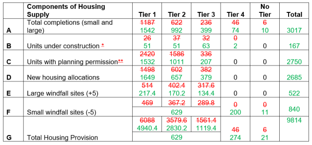
MAC 124
Action Point / Reason
AP2/6
To ensure the content of the Plan reflects the actions arising from the Examination
Matters Arising Changes
Update Appendix 7 – Housing Trajectory and Graph
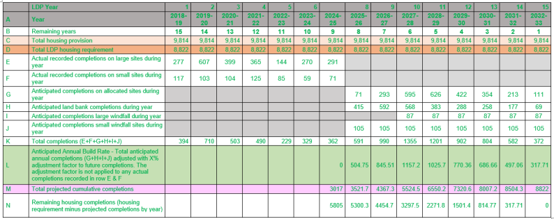
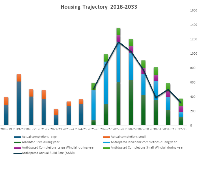
MAC 125
Action Point / Reason
AP1/6
To ensure the content of the Plan reflects the actions arising from the Examination
Matters Arising Changes
Add a new appendix containing a schedule which provides details of the regeneration and mixed-use sites, phasing requirements, constraints, infrastructure requirements and planning obligations.
|
Site Ref. |
Location and Proposed Uses |
|
PrC1/MU1 |
West Carmarthen, Carmarthen Identified as a strategic site in the adopted LDP, the West Carmarthen site continues to be identified as a mixed-use site for a variety of uses including residential (with an allowance for 700 new homes within this plan period), new Primary School, amenity/recreation, employment and community facilities. A Planning &; Development Brief was adopted for the site in 2010 and development is taking place in accordance with it. A major spine road has been completed and residential development has commenced and is continuing to be built on the site. Phasing Requirement Refer to the housing trajectory. Residential development has commenced and is expected to be delivered in every year of the remaining plan period. Delivery of the non-residential elements is expected towards the end of the plan period. Constraints
Infrastructure Requirements
Planning Obligations
|
|
PrC1/MU2 |
Pibwrlwyd, Carmarthen The site is allocated for a mix of uses reflecting its strategic location and contribution to Carmarthen. Uses include employment, commercial leisure, education associated with Coleg Sir Gâr and residential (an allowance is made for 247 new homes). Phasing Requirement Refer to the housing trajectory. Residential development is expected to be delivered towards the end of the plan period. Other uses are also expected to be delivered towards the end of the plan period. Constraints
Infrastructure Requirements
Planning Obligations
|
|
PrC2/MU1 |
Former Old Castle Works, Llanelli Mix of uses focused on the visitor economy, heritage and leisure and associated landscaping across the 3.4ha site, including the renovation of the Grade II Listed Building known as the Tinhouse (750sqm). The site is previously developed land and part of a regeneration proposal consisting of less vulnerable uses. The site is within immediate proximity to the Millennium Coastal Park. No residential allowance has been made. Phasing Requirement: No phasing requirement identified. Constraints:
Infrastructure requirements:
Planning obligations. Not applicable unless highway improvements are required as part of any scheme. |
|
PrC2/MU2 |
Trostre Gateway, Llanelli Detail: Mix of uses including the development of a Class A1 Foodstore and a Drive-Thru Coffee Shop, with associated access, car parking and landscaping which has been developed in the early years of the Revised LDP plan period. A small parcel of land remains on the western side which would support a small-scale retail led use of approximately 250m² gross floor space, reflecting its prominent location and planning history. Phasing Requirement: No phasing requirement identified. Constraints:
Infrastructure requirements:
Planning obligations. Not applicable |
|
PrC2/MU3 |
Former YMCA Building, Stepney Street, Llanelli Town Centre The site has been completed and comprise of office / retail spaces on the ground floor. 8 residential units have been completed on the upper floors of the development. |
|
PrC3/MU1 |
Emlyn Brickworks, Penygroes A previously developed site which previously comprised a brickworks and coal mining activity but currently lies vacant. The site is to be developed for 177 new homes and a smaller portion of the site to be used for a community focused development. Phasing The site has full planning permission for 70 dwellings along the northern part of the site on land between Norton Road and the Cross Hands Economic Link Road spur to Norton Road. This phase of the site will be the first to be delivered under the lifetime of the rLDP. The remainder of the site does not benefit from planning consent, and its delivery will follow the first stage of development at the northern section of the site. Refer to the rLDP trajectory for further detail. Constraints
Infrastructure Requirements
Planning Obligations
|
|
SeC4/MU1 |
Burry Port Waterfront The mixed-use allocation is split into two separate areas of land. The northern element of the allocation includes for the potential of a mix of uses focused on appropriate retail provision of up to 2,000m². gross floor space, along with commercial / tourism related uses. The southern part of the site is part of the Burry Port Masterplan area (Site 4) The site has outline planning permission for commercial leisure development comprising of a mix of retail, hotel, pub/restaurant and residential uses of up to 5,000m² gross floor space. No residential allowance has however been made within Policy HOM1 – Housing Allocations. Phasing: The northern element will have the potential for a scheme to come together towards the end of the plan period. The southern element of the mixed-use site has outline planning permission with the application for the approval of Reserved Matters to be made to the Local Planning Authority by the 25th November 2027. It is considered that development will take place towards the end of the Plan period. Constraints
Infrastructure Requirements
Planning Obligations Not applicable. |
|
SeC16/MU1 |
Beechwood, Llandeilo The site includes a mix of uses reflecting its strategic location and contribution to Llandeilo. Uses include a mix of appropriate B1 employment starter units and offices (approximately 3020sqm),and retail (A1 and A3 of up to 1700sqm gross floor space). The site forms part of a larger area which has been included within development limits but has been identified as a C2 flood risk zone. Applications will need to satisfy all requirements in this respect. Phasing Not applicable Constraints
Infrastructure Requirements The site is located very close to the main A40 trunk road which connects West Wales with the Midlands. The site benefits from readily available utilities that service the existing employment operations on the well - established industrial estate to the east, through which this site is accessed. Planning Obligations Not applicable unless highway improvements are required as part of any scheme. |
|
SeC20/MU1 |
Laugharne Holiday Park The site consists of a mix of uses focused on tourism and leisure associated with the re-development of Laugharne Holiday Park, which is now known as Dylan Coastal Resort. The allocated area is now mostly complete with a small area in the north of the site yet to be developed. . Phasing Not applicable Constraints Any constraints would have been considered and overcome as part of the planning application for the redevelopment of the site under planning permissions W/24265 and W/34546. There are no constraints to the development of the remaining allocated land. Infrastructure Requirements Any infrastructure requirements would have been considered as part of the planning application for the redevelopment of the site W/24265 and W/34546. Planning Obligations Not applicable |
|
PrC1/MU3 |
Nant y Caws Regeneration and Mixed-Use Site A strategically positioned site already utilised for the sustainable management of waste. It offers the future opportunity to potentially harness energy, and related employment-based activities. The consolidation of future opportunities on the site will be set out through the development of a masterplan. Phasing To be considered as part of a potential masterplan for the site. Constraints Flooding - whilst not affected by TAN15 DAMs flood zones, there are NRW Floodzone small watercourse zones 2&;3 on parts of site. Transport – potential highway/access improvements required. Peat – minimal amount on peripheral part of the site, should not impede future proposals. Infrastructure Requirements Potential for new road infrastructure (access improvements) to be undertaken. Main utilities already in place servicing the existing operations at the site. Planning Obligations Not applicable unless highway improvements are required as part of any scheme. |
MAC 126
Action Point / Reason
AP2/5
AP6/21
To ensure the content of the Plan reflects the actions arising from the Examination
Matters Arising Changes
New Appendix 10:
Inclusion of flood constraint information
Cluster 1
|
Site Ref. / Site Name |
PrC1/h4 - Land off Parc y Delyn, Carmarthen |
|
Site Size (ha) |
1.46 |
|
Total Units / Affordable Units |
17 homes. Affordable Housing – 1.7 affordable homes. Provision in accordance with Policy AHOM1. |
|
Phasing |
2029- 2031 (Years 12 and 13 of the plan period) |
|
Site Description |
The site comprises of two fields adjacent to residential development and has a strong, defined boundaries. |
|
Flood Risk |
Flood Zone 1 (Rivers &; Sea): Surface Water and Small Watercourses: Flood Zone 1. |
|
Key Considerations and Constraints |
Highways &; Transport - The width of the Penylan Road may need addressing. Environmental Constraints – Hedgerows and ecological surveys will require consideration on submission of a planning application. Air Quality – An Air Quality Assessment may be required on submission of a planning application. |
|
Site Ref. / Site Name |
PrC1/h5 - East of Devereaux Drive, Carmarthen |
|
Site Size (ha) |
0.294 |
|
Total Units / Affordable Units |
10 homes. Affordable Housing – 5 affordable dwellings. Provision in accordance with Policy AHOM1. |
|
Phasing |
2027-28 (Year 10 of the plan period) |
|
Site Description |
The site consists of part of a sloping, larger field and lies opposite existing residential development. |
|
Flood Risk |
Flood Zone 1 Rivers &; Sea: Surface Water and Small Watercourses: Flood Zone 1. |
|
Key Considerations and Constraints |
Highways &; Transport – No known issues. Environmental Constraints – Retention of hedges and trees. |
|
Site Ref. / Site Name |
PrC1/h8 - Llansteffan Road, Carmarthen |
|
Site Size (ha) |
1.58 |
|
Total Units / Affordable Units |
50 homes. Affordable Housing – The site is Council owned and the intention is to deliver 100% affordable housing. |
|
Phasing |
2025-2027 (Years 8 &; 9 of the plan period) |
|
Site Description |
The site used to house a former Comprehensive School which has since been demolished and the land restored. Located adjacent to Carmarthen Leisure Centre. |
|
Flood Risk |
Flood Zone 1 Rivers &; Sea Surface Water and Small Watercourses: The majority of the site falls within Zone 1, and a small portion falls within the Zone 2. |
|
Key Considerations and Constraints |
Highways &; Transport – No known issues. Environmental Constraints – The site is located close to the Tywi Special Area of Conservation. Woodland to the south. Flooding - The site may require a Flood Consequences Assessment. The site’s design and layout will need to consider flood risk and avoid placing dwellings on the affected areas. The most recent flooding data will need to be considered at planning application stage. |
|
Site Ref. / Site Name |
PrC1/h10 - Brynhyfryd, Carmarthen |
|
Site Size (ha) |
1.379 |
|
Total Units / Affordable Units |
20 homes. Affordable Housing – 2.4 affordable dwellings. Provision in accordance with Policy AHOM1. |
|
Phasing |
2026-2028 (Years 9 &; 10 of the plan period) |
|
Site Description |
The site is an agricultural field which represents a logical extension to Llangunnor. |
|
Flood Risk |
Flood Zone 1 Rivers &; Sea Surface Water and Small Watercourses: Flood Zone 1. |
|
Key Considerations and Constraints |
Highways &; Transport – No known issues. Environmental Constraints – Trees and hedgerows. |
|
Site Ref. / Site Name |
PrC1/h12 - Castell Pigyn Road, Abergwili, Carmarthen |
|
Site Size (ha) |
1.6 |
|
Total Units / Affordable Units |
35 homes.. Affordable Housing – 4.2 affordable dwellings. Provision in accordance with Policy AHOM1. |
|
Phasing |
2025-2029 (Years 8-11 of the plan period) |
|
Site Description |
The site consists of a relatively flat agricultural field adjoining Abergwili. |
|
Flood Risk |
Flood Zone 1 Rivers &; Sea &; part in Zone 2 (Rivers). Surface Water and Small Watercourses: The majority of site is zone 1 with a small portion falling within Zones 2 &; 3. |
|
Key Considerations and Constraints |
Highways &; Transport – No known issues. Environmental Constraints –Hedgerows. Flooding – A Flood Consequences Assessment will be required. |
|
Site Ref. / Site Name |
PrC1/(iv) – Land off Trevaughan Road, Carmarthen |
|
Site Size (ha) |
1.63 |
|
Total Units / Affordable Units |
30 homes. Affordable Housing – 3.6 affordable dwellings. Provision in accordance with Policy AHOM1. |
|
Phasing |
2029-2031 (Years 12-13 of the plan period) |
|
Site Description |
Edge of settlement greenfield site with a hedgerow boundary along its entire road frontage. |
|
Flood Risk |
Flood Zone 1 Rivers &; Sea Surface Water and Small Watercourses: The majority of site is zone 1 with a small portion falling within Zones 2 &; 3. |
|
Key Considerations and Constraints |
Highways &; Transport – Any access junction shall be considered in line with Carmarthenshire County Council standards and shall be situated at least 33 metres (centreline to centreline) away from the Derwen Fechan junction (opposite junction spacing). Environmental Constraints – There will be a requirement to retain hedgerows, trees and provide buffers. Flooding - The site may require a Flood Consequences Assessment. The site’s design and layout will need to consider flood risk and avoid placing dwellings on the affected areas. The most recent flooding data will need to be considered at planning application stage |
|
Site Ref. / Site Name |
PrC1/MU1 - West Carmarthen, Carmarthen |
|
Site Size (ha) |
65.03 (whole site) |
|
Total Units / Affordable Units |
222 homes. Affordable Housing – 84 affordable dwellings for the total site. |
|
Phasing |
2026-2033 (Years 9-15 of the plan period) |
|
Site Description |
The wider site is allocated as a mixed-use site providing for a variety of uses including residential (with an allowance for 700 new homes within this plan period), new Primary School, amenity/recreation, employment and community facilities. A Planning &; Development Brief was adopted for the site in 2010, and development is taking place in accordance with it. A major spine road has been completed and residential development has commenced and is continuing to be built on the site. The site has a number of landowners, and as a result its development is being delivered on a phased basis |
|
Flood Risk |
Rivers &; Sea: Flood Zones, 1, 2 and 3(Rivers). Elements subject to flooding have been excluded from the areas to be developed Surface Water and Small Watercourses: The majority of site is Zone 1 with a small portion falling within Zones 2 &; 3. |
|
Key Considerations and Constraints |
Highways &; Transport – No known issues. A link road has been completed through the site. Environmental Constraints – Ecological and biodiversity studies will be required to support planning applications. Protection of hedgerows will need protection. Commuted Sum towards community benefits consisting of community facilities and a primary school, as identified in the West Carmarthen Planning and Dev Brief, and the West Carmarthen Link Road. Provision of LAP / LEAP. Built Environment – Archaeological and historic environment. Part of the site lies adjacent to a Conservation Area. Flooding - The site may require a Flood Consequences Assessment. The site’s design and layout will need to consider flood risk and avoid placing dwellings on the affected areas. The most recent flooding data will need to be considered at planning application stage |
|
Site Ref. / Site Name |
PrC1/MU2 - Pibwrlwyd, Carmarthen |
|
Site Size (ha) |
31.96 (whole site) |
|
Total Units / Affordable Units |
247 homes. Affordable Housing – 61.75 affordable dwellings. Provision in accordance with Policy AHOM1. |
|
Phasing |
2028-2033 (Years 11-15 of the plan period) |
|
Site Description |
The site consists of a number of undulating greenfield parcels of land. It is strategically located on the southern gateway to Carmarthen and is bordered by the A48 trunk road on its east and the A484 on its west. The site itself is slightly sloping in parts, with the northern section of the site (Heol Glasdwr) having been regraded and levelled. The site is allocated for a mix of uses reflecting its strategic location and contribution to Carmarthen. Uses include employment, commercial leisure, education associated with Coleg Sir Gâr and residential (an allowance is made for 247 new homes). |
|
Flood Risk |
Flood Zone 1 Rivers &; Sea Surface Water and Small Watercourses: The majority of site is Zone 1 with a small portion falling within Zones 2 &; 3. |
|
Key Considerations and Constraints |
Highways &; Transport – Proximity to A48 – highway considerations. Environmental Constraints – Protection of hedgerows. Air quality assessment may be required. Commuted Sum towards community benefits in line with Policy INF1. Contribution towards parks and open space in accordance with the Plan’s policies. Utilities – Hydraulic modelling may be required. A water main and foul sewers cross the site. Flooding - The site may require a Flood Consequences Assessment. The site’s design and layout will need to consider flood risk and avoid placing dwellings on the affected areas. The most recent flooding data will need to be considered at planning application stage |
|
Site Ref. / Site Name |
SeC1/h4 - Cae Canfas, Heol Llanelli, Pontyates |
|
Site Size (ha) |
0.58 |
|
Total Units / Affordable Units |
8 homes. Affordable Housing –Provision in accordance with Policy AHOM1 (commuted sum contribution) |
|
Phasing |
2026- 2030 (Years 9 to 12 of the plan period) |
|
Site Description |
Flat parcel of land which is part of the Cae Canfas Farm complex. Within the developed area of Pontaytes with residential development to the north and east. Access provision is in place via Heol Llanelli. Site boundaries with minimal ecological value. |
|
Flood Risk |
Flood Zone 1 (Rivers &; Sea) |
|
Key Considerations and Constraints |
Highways &; Transport – No highway issues identified. Environmental Constraints – The proximity to the farm may need to be considered within the design. Potential for high value, low density development Commuted Sum – Potential for planning contributions in line with Policy INF1 Utilities – No issues identified in bringing the site forward for development. |
|
Site Ref. / Site Name |
SeC1/h7 - Land off Heol Glyndwr, Pontyates |
|
Site Size (ha) |
0.459 |
|
Total Units / Affordable Units |
9 homes. Affordable Housing – 2 affordable dwellings. Provision in accordance with Policy AHOM1 |
|
Phasing |
2025- 2029 (Years 8 to 11 of the plan period) |
|
Site Description |
Undeveloped field enclosure to the north west of Heol Glyndwr which is set off the B4309 Heol y Meinciau Road. The fields frontage adjoins Heol Glyndwr at the south eastern edge of the site which is a private road which hosts three other properties. The application site is gently sloping towards a lowest point off its southern boundary and is roughly square in shape. |
|
Flood Risk |
Flood Zone 1 (Rivers &; Sea) |
|
Key Considerations and Constraints |
Highways &; Transport – Highway access provision to the site is acceptable. Environmental Constraints –. Protection of hedgerow and tree boundaries. A European protected species License is required for this development. Affordable Housing – Provision in accordance with the figure set out in Policy AHOM1. Commuted Sum towards community benefits in line with Policy INF1. Contribution towards parks and open space in accordance with Policy PSD8. Utilities – No issues identified in bringing the site forward for development. |
|
Site Ref. / Site Name |
SeC2/h2 - Land to the rear of Parc y Ffynnon, Ferryside |
|
Site Size (ha) |
0.539 |
|
Total Units / Affordable Units |
12 homes. Affordable Housing – 1.2 affordable dwellings. Provision in accordance with Policy AHOM1 |
|
Phasing |
2026- 2029 (Years 9 to 11 of the plan period) |
|
Site Description |
The site slopes down from a south to north direction and to the rear of several dwellings within the Parc y Ffynnon estate. The land is currently vacant with no existing use. |
|
Flood Risk |
Flood Zone 1 (Rivers &; Sea) |
|
Key Considerations and Constraints |
Highways &; Transport – Highway access provision to the site is acceptable through Parc y Ffynnon Environmental Constraints – Protection of hedgerow and tree boundaries on the south-western boundary. Commuted Sum towards community benefits in line with Policy INF1. Amenity: Consideration needed to be given to the topography of the site and to the amenity of neighbouring dwellings. Utilities – No issues identified in bringing the site forward for development. |
|
Site Ref. / Site Name |
SuV1/h1 - Adjacent Fron Heulog, Cynwyl Elfed |
|
Site Size (ha) |
0.59 (whole site) |
|
Total Units / Affordable Units |
2 homes. Affordable Housing – A commuted sum will be sort in accordance with Policy AHOM1. |
|
Phasing |
2029-2031 (Years 12 &; 13 of the plan period) |
|
Site Description |
The wider site is allocated for 8 dwellings which is partly constructed / under construction. |
|
Flood Risk |
Flood Zone 1 Rivers &; Sea: Surface Water and Small Watercourses: Flood Zone 1. |
|
Key Considerations and Constraints |
Highways &; Transport – No known issues. Environmental Constraints – Trees and hedgerows. |
|
Site Ref. / Site Name |
SuV1/h2 - Land adj. Lleine, Cynwyl Elfed |
|
Site Size (ha) |
0.72 |
|
Total Units / Affordable Units |
13 homes. Affordable Housing – 1.3 affordable dwellings. Provision in accordance with Policy AHOM1. |
|
Phasing |
2026-2033 (9-15 Years of the plan period) |
|
Site Description |
A greenfield and sloping site located on the outskirts of Cynwyl Elfed. |
|
Flood Risk |
Flood Zone 1 - Rivers &; Sea: Surface Water and Small Watercourses: Flood Zone 1. |
|
Key Considerations and Constraints |
Highways &; Transport – No known issues. Environmental Constraints – Hedgerows to be retained. |
|
Site Ref. / Site Name |
SuV4/h1 - Land at Troed Rhiw Farm, Bronwydd |
|
Site Size (ha) |
0.631 |
|
Total Units / Affordable Units |
6 homes Affordable Housing – commuted sum contribution towards affordable housing in accordance with Policy AHOM1 |
|
Phasing |
2026 – 2029 (Years 9-11 of the plan period) |
|
Site Description |
The site comprises a flat parcel of agricultural land which represents the frontage of a larger field. The site can accommodate 6 plots in a linear pattern of development. The site adjoins existing residential development to the south and opposite the site to the east beyond the B4301 road. |
|
Flood Risk |
Flood Zone 1 (Rivers &; Sea) but lies adjacent to Flood Zone 3 for Rivers |
|
Key Considerations and Constraints |
Highways &; Transport – The site can be accessed directly from the B4301. Environmental Constraints – Hedgerow along the site’s frontage. Planning Obligations – Contributions will be required in accordance with the rLDP’s policies, these are likely to include a financial contribution towards affordable housing and public open space. Flooding - The site lies nearby flood zone 3 (Rivers) and may require a Flood Consequences Assessment. The most recent flooding data will need to be considered at planning application stage. |
|
Site Ref. / Site Name |
SuV10/h2 - Aberdeuddwr / Pantyfedwen, Peniel |
|
Site Size (ha) |
0.625 |
|
Total Units / Affordable Units |
38 dwellings. Affordable Housing – 4.56 affordable dwellings. Provision in accordance with Policy AHOM1. |
|
Phasing |
2026-2030 (Years 9-12 of the plan period) |
|
Site Description |
A greenfield site located on the northern outskirts of Peniel. |
|
Flood Zone |
Flood Zone 1- Rivers &; Sea Surface Water and Small Watercourses: Flood Zone 1. |
|
Key Considerations and Constraints |
Highways &; Transport – No known issues. Environmental Constraints – Hedgerows and trees to be retained. |
|
Site Ref. / Site Name |
SuV11/h1 - Land at Alltwalis School, Alltwalis |
|
Site Size (ha) |
0.353 |
|
Total Units / Affordable Units |
12 dwellings. Affordable Housing – The site is Council owned and the intention is to deliver 100% affordable housing. |
|
Phasing |
2025-26 (Year 8 of the plan period). |
|
Site Description |
The site is a greenfield site located on the edge of Alltwalis and will form an extension to Troed-yr-Allt. The site is currently owned by the Council. |
|
Flood Risk |
Flood Zone 1 - Rivers &; Sea: Surface Water and Small Watercourses: Flood Zone 1. |
|
Key Considerations and Constraints |
Highways &; Transport – No known issues. Environmental Constraints – Hedgerows and trees to be retained. A bat survey may be required. Flooding – The site’s borders Flood Zone 2 &; 3 (Rivers) and would require a Flood Consequences Assessment. The most recent flooding data will need to be considered at planning application stage. Utilities – A foul sewer crosses the site. |
|
Site Ref. / Site Name |
SuV12/h1 - Adj. Gwyn Villa, Llanpumsaint |
|
Site Size (ha) |
1.516 |
|
Total Units / Affordable Units |
20 dwellings Affordable Housing – 2.4 affordable dwellings. Provision in accordance with Policy AHOM1. |
|
Phasing |
2027-2031 (Years 10-13 of the plan period) |
|
Site Description |
A greenfield site located on the edge of Llanpumsaint. |
|
Flood Risk |
Flood Zone 1 - Rivers &; Sea Surface Water and Small Watercourses: The majority of site is Zone 1 with a small portion falling within Zone 2. |
|
Key Considerations and Constraints |
Highways &; Transport – no known issues. Environmental Constraints – Hedgerows and trees to be retained. Commuted Sum towards community benefits in line with Policy INF1 Utilities – A water main and foul sewer crosses the site. Flooding - The site may require a Flood Consequences Assessment. The site’s design and layout will need to consider flood risk and avoid placing dwellings on the affected areas. The most recent flooding data will need to be considered at planning application stage. |
|
Site Ref. / Site Name |
SuV12/h2 – Llandre, Llampumsaint |
|
Site Size (ha) |
0.43 (whole site) |
|
Total Units / Affordable Units |
4 dwellings. Affordable Housing – A commuted sum will be sought in accordance with Policy AHOM1. |
|
Phasing |
Years 8-11 of the plan period |
|
Site Description |
The majority of the site has been built and this forms the remaining land of Bro Cerwyn cul-de-sac. |
|
Flood Risk |
Flood Zone 1 - Rivers &; Sea: Flood Zone 1. - Surface Water and Small Watercourses: |
|
Key Considerations and Constraints |
Highways &; Transport – no known issues. Commuted Sum towards community benefits in line with Policy INF1. |
|
Site Ref. / Site Name |
SuV14/h1 - Cefn Farm, Rhydargaeau |
|
Site Size (ha) |
1.852 (whole site) |
|
Total Units / Affordable Units |
17 dwellings. Affordable Housing – 3.7 affordable dwellings. Provision in accordance with Policy AHOM1. |
|
Phasing |
2025-2029 (Years 8-11 of the plan period) |
|
Site Description |
Part of the site has been completed, this element forms the remainder of the site. The greenfield site is a continuation of the Clos y Fedw / Dan y Dderwen development. |
|
Flood Risk |
Flood Zone 1 Rivers &; Sea: Surface Water and Small Watercourses: The majority of site is Zone 1 with a small portion falling within Zone 2. |
|
Key Considerations and Constraints |
Highways &; Transport – no issues. Commuted Sum towards community benefits in line with Policy INF1 Flooding - The site may require a Flood Consequences Assessment. The site’s design and layout will need to consider flood risk and avoid placing dwellings on the affected areas. The most recent flooding data will need to be considered at planning application stage. |
|
Site Ref. / Site Name |
SuV16/h1 - Llwynddewi Road, Capel Dewi |
|
Site Size (ha) |
0.625 (includes committed site area) |
|
Total Units / Affordable Units |
2 dwellings. Affordable Housing – A commuted sum contribution will be sought in accordance with Policy AHOM1. |
|
Phasing |
2026-27 (Year 9 of the plan period) |
|
Site Description |
Development of the site has commenced and is being progressed on a plot by plot basis. Only 2 plots remain to be developed. The site comprises a development of 8 units along a minor road within the built form of Capel Dewi, south of the B4300. The final 2 plots to be developed are currently vacant grassland. |
|
Flood Risk |
Flood Zone 1 (Rivers &; Sea) A small part of the site (already completed) falls within the zones 2 and 3 for surface water and small watercourses. The remainder of the allocation is not affected by any flood risk zone. |
|
Key Considerations and Constraints |
Highways &; Transport - No known issues Nutrients – There will be a need to satisfy the requirement to address phosphate levels associated with the development in line with Policy CCH4. |
|
Site Ref. / Site Name |
SuV17/h1 - Rear of former joinery, Station Road, Nantgaredig |
|
Site Size (ha) |
1.512 |
|
Total Units / Affordable Units |
35 dwellings Affordable Housing - 4.2 affordable dwellings. Provision in accordance with Policy AHOM1 |
|
Phasing |
2026-2029 (Years 9-11 of the plan period) |
|
Site Description |
The site consists of a generally level agricultural field, immediately adjacent to the existing built form of Nantgaredig. It is accessed from the B4310 which runs through the settlement and is within a short distance of the main A40 trunk road. |
|
Flood Risk |
Flood Zone 1 (Rivers &; Sea) A small part of the site falls within the zones 2 and 3 for surface water and small watercourses. |
|
Key Considerations and Constraints |
Highways &; Transport – No adverse issues have been identified. Environmental Constraints: No significant constraints have been identified. Considerations that may need addressing at the planning application stage include: Nutrients – There will be a need to satisfy the requirement to address phosphate levels associated with the development in line with Policy CCH4. Flooding - The site may require a Flood Consequences Assessment. The site’s design and layout will need to consider flood risk and avoid placing dwellings on the affected areas. The most recent flooding data will need to be considered at planning application stage. |
|
Site Ref. / Site Name |
SuV19/h2 - Land adj. and the r/o Haulfan, Llanddarog |
|
Site Size (ha) |
0.863 |
|
Total Units / Affordable Units |
10 homes Affordable Housing - 1 affordable home in accordance with Policy AHOM1 |
|
Phasing |
2027 – 2030 (Years 10-12 of the plan period) |
|
Site Description |
The site comprises part of a level agricultural field and the side garden of an existing residential property (Haulfan). The site is encompassed by existing residential development on all sides except to the south-west where the remaining part of the agricultural field lies. |
|
Flood Risk |
Flood Zone 1 (Rivers and Sea) Flood Zone 1 - Surface Water and Small Watercourses: |
|
Key Considerations and Constraints |
Highways &; Transport – The site can be accessed directly from the B4310. Environmental Constraints – Ecology - Minimise hedgerow damage along site boundaries. Utilities -Public sewerage– Foul sewer crossing the site which will need to be considered at planning application stage and during construction. Planning Obligations – Contributions will be required in accordance with the rLDP’s policies, these are likely to include affordable housing; public open space; and education. Flooding – The site has not been identified at risk of flooding. The most recent flood maps will need to be considered at the planning application stage. |
|
Site Ref. / Site Name |
SuV20/h1 - Land adjacent to Llwynhenry Farm, Porthyrhyd |
|
Site Size (ha) |
0.514 |
|
Total Units / Affordable Units |
6 Affordable Housing – commuted sum contribution towards affordable housing in accordance with Policy AHOM1 |
|
Phasing |
2025 – 2031 (Years 8-13 of the plan period) |
|
Site Description |
The site comprises part of an agricultural field. The site adjoins existing residential development to the north, the B4310 road to the west and agricultural land to the south. Hedgerows line the site’s boundaries, other than to the south where there is no physical boundary. The site’s topography rises eastwards away from the B4310 road. |
|
Flood Risk |
Flood Zone 1 (Rivers and Sea) but lies adjacent to flood zone 2 and 3 for rivers. Flood Zone 1. - Surface Water and Small Watercourses: |
|
Key Considerations and Constraints |
Highways &; Transport – Access to the site is achievable from the unclassified road running north-eastwards from the B4310 road along the site’s northern boundary. A new footway / pavement may be required to connect the site to existing provision. Topography – At its highest point the site is prominently visible from the B4310. Therefore, consideration will need to be given to the site’s layout and landscaping in order to minimise its impact upon visual amenity. Utilities - Water supply– Off site mains will be required to serve the development. A trunk main is located near the site which may require an easement, Welsh Water should therefore be consulted at planning application stage. Planning Obligations – Contributions will be required in accordance with the rLDP’s policies, these are likely to include a financial contribution towards affordable housing and public open space. Flooding - The site’s borders flood zone 2 &; 3 (Rivers) and may require a Flood Consequences Assessment. The most recent flooding data will need to be considered at planning application stage. |
Cluster 2
|
Site Ref. / Site Name |
PrC2/h1 - Beech Grove, Pwll |
|
Site Size (ha) |
0.719 |
|
Total Units / Affordable Units |
10 dwellings. Affordable Housing – 1 affordable dwelling. Provision in accordance with Policy AHOM1 |
|
Phasing |
2026 – 2028 (Years 9 and 10 of the Plan period) |
|
Site Description |
Parcel of agricultural land located on the northern part of Pwll and sloping upwards from a south to north directions. It is bordered by residential properties on the southern and eastern side with the western side bordered by hedgerows. It is directly accessed from Maes yr Haf and Beech Grove. |
|
Flood Risk |
Flood Zone 1 (Rivers &; Sea) Flood Zone 1 - Surface Water and Small Watercourses: |
|
Key Considerations and Constraints |
Highways &; Transport – The site can be accessed from Beech Grove. Environmental Constraints: Consideration will need to be given to the removal of part of the hedgerows on the western in order to gain a suitable access into the site Commuted Sum towards community benefits in line with Policy INF1. Amenity: Consideration needed to be given to the topography of the site and to the amenity of neighbouring dwellings. Utilities – No issues identified in bringing the site forward for development. |
|
Site Ref. / Site Name |
PrC2/h10 - Land adjacent to The Dell, Furnace |
|
Site Size (ha) |
3.338 |
|
Total Units / Affordable Units |
13 dwellings. Affordable Housing – 1.3 affordable dwellings. Provision in accordance with Policy AHOM1 |
|
Phasing |
2025 – 2027 (Years 8 and 9 of the Plan period) |
|
Site Description |
Former Quarry site set on the northern eastern side of Furnace, with an access onto the B4309 Ynys y Cwm Road. |
|
Flood Risk |
Flood Zone 1 (Rivers &; Sea). A small part of the site falls within zones 2 &; 3 for surface water and small watercourses |
|
Key Considerations and Constraints |
Highways &; Transport – The site can be accessed from Ynys Y Cwm Road. Environmental Constraints: Any planning application will need to consider ecology and habitat within the site and the potential mitigation through the reduction of the developable area to satisfy the criteria of the Stepwise approach set out within Chapter 6 of Planning Policy Wales 12. Surrounding woodland to be retained to maintain a green corridor providing connectivity with the main woodland and the Dell. Flooding - The site may require a Flood Consequences Assessment. The site’s design and layout will need to consider flood risk and avoid placing dwellings on the affected areas. The most recent flooding data will need to be considered at planning application stage. Commuted Sum towards community benefits in line with Policy INF1. Utilities – No issues identified. |
|
Site Ref. / Site Name |
PrC2/h20 - Harddfan, Bryn |
|
Site Size (ha) |
0.155 |
|
Total Units / Affordable Units |
6 dwellings Affordable Housing – Council owned site to be delivered for a 100% affordable scheme. Otherwise provision in accordance with Policy AHOM1 (commuted sum contribution) |
|
Phasing |
2025-26 (Year 8 of the Plan period) |
|
Site Description |
The site is a flat and a triangular parcel of grassed land within the Harddfan estate. The site has a hedgerow and tree lined border on the southern side and residential properties on the northern and eastern side. |
|
Flood Risk |
Flood Zone 1 (Rivers &; Sea) Flood Zone 1 - Surface Water and Small Watercourses: |
|
Key Considerations and Constraints |
Highways &; Transport – Direct access to the Harddfan estate road. Environmental Constraints: Consideration will need to be given to the hedgerows and trees on the southern boundary. Commuted Sum towards community benefits in line with Policy INF1. Utilities – No issues identified. |
|
Site Ref. / Site Name |
PrC2/h23 - Dafen East Gateway |
|
Site Size (ha) |
5.471 |
|
Total Units / Affordable Units |
150 dwellings. Affordable Housing – 45 affordable dwellings. Provision in accordance with Policy AHOM1. |
|
Phasing |
2026-2031 (Years 9-13 of the plan period) |
|
Site Description |
Large parcel of agricultural land set on the entrance to Dafen / Llanelli along the A4138. The site has good pedestrian / cycle linkages to other parts of the town. The site slopes downwards from east to west. Hedgerows and tree coverage form the boundary on the eastern side with the remainder of the site being relatively open. |
|
Flood Risk |
Flood Zone 1 (Rivers &; Sea). A very small part of the site falls within the zone 2 &; 3 for surface water and small watercourses |
|
Key Considerations and Constraints |
Highways &; Transport – Direct access to the A4138 Environmental Constraints: Consideration will need to be given to the hedgerows and trees on the eastern boundary with the requirement for ecological and habitat mitigation. Commuted Sum towards community benefits in line with Policy INF1. Flooding - The site may require a Flood Consequences Assessment. The site’s design and layout will need to consider flood risk and avoid placing dwellings on the affected areas. The most recent flooding data will need to be considered at planning application stage. Amenity: Consideration should be given to the neighbouring land uses, including issues of noise and disturbance. This will impact on the design and layout of the development. Utilities – No issues identified in bringing the site forward for development. |
|
Site Ref. / Site Name |
PrC2(iii) Land at Pendderi Road |
|
Site Size (ha) |
0.96 |
|
Total Units / Affordable Units |
35 dwellings Affordable Housing – 4.2 affordable dwellings. Provision in accordance with Policy AHOM1. |
|
Phasing |
2026-2028 (Years 9-10 of the plan period) |
|
Site Description |
Parcel of agricultural land immediately adjacent to an existing large scale housing development. Immediate access on to Pendderi Road or Genwen Road |
|
Flood Risk |
Flood Zone 1 (Rivers &; Sea). A very small part of the site falls within the zone 2 for surface water and small watercourses |
|
Key Considerations and Constraints |
Highways &; Transport – Potential access junction could be achieved from both Genwen and Pendderi Roads. Improvements to highway width and footway provisions likely required. Environmental Constraints: Consideration will need to be given to the ecology and habitat mitigation as part of any planning application. Flooding - The site’s design and layout may need to consider flood risk given the small area within zone 2 for surface water and small watercourses Commuted Sum towards community benefits in line with the conditions of the outline planning permission for the whole site. Amenity: Consideration should be given to the neighbouring land uses. Utilities – No issues identified in bringing the site forward for development. |
|
Site Ref. / Site Name |
PrC2/(v)Land off Heol y Mynydd |
|
Site Size (ha) |
5.34 |
|
Total Units / Affordable Units |
80 dwellings Affordable Housing – 45 affordable dwellings. Provision in accordance with Policy AHOM1. |
|
Phasing |
2027-2029 (Years 10-11 of the plan period) |
|
Site Description |
Parcels of improved grassland / agricultural land set behind dwellings along Heol y Mynydd. |
|
Flood Risk |
Flood Zone 1 (Rivers &; Sea). A very small part of the site falls within the zone 2&;3 for surface water and small watercourses. |
|
Key Considerations and Constraints |
Highways &; Transport – Appears to be some 10m width (including verges) to allow a compliant access depending on land ownership and detailed design. Environmental Constraints: Consideration will need to be given to the hedgerows and trees on the field boundaries with the requirement for ecological and habitat mitigation. Flooding - The site may require Flood Consequences Assessment. The site’s design and layout will need to consider flood risk Commuted Sum towards community benefits in line with the conditions of the outline planning permission for the whole site. Amenity: Consideration should be given to the neighbouring land uses. Utilities – No issues identified in bringing the site forward for development. |
|
Site Ref. / Site Name |
PrC2/SS1 - Pentre Awel |
|
Site Size (ha) |
22.31 |
|
Total Units / Affordable Units |
240 dwellings Affordable Housing – 45 affordable dwellings. Provision in accordance with Policy AHOM1. |
|
Phasing |
2025-2029 (Years 8-11 of the plan period) |
|
Site Description |
Land as part of the overall strategic development at Pentre Awel. Residential development is to be considered as part of Phase 2 and other future phases, with a mix of tenures and housing types on the site. |
|
Flood Risk |
Flooding – Parts of the site fall within the NRW flood Zone rivers (zone 2&;3) and flood zone seas (2&;3) however the Variation of Condition application and the subsequent permission to extend the time to submit Reserved Matters includes an updated FCA which has been accepted by NRW. Approximately half the site falls within the zone 2&;3 for surface water and small watercourses. |
|
Key Considerations and Constraints |
Highways &; Transport – No identified issues with the access to the site with the development to be absorbed into the existing road network. Environmental Constraints: Consideration will need to be given to the ecology and habitat mitigation as part of any further detailed planning application for phase 2. Significant opportunity to bring previously developed land into beneficial use. Flooding - The site may require further Flood Consequences Assessment. The site’s design and layout will need to consider flood risk and avoid placing dwellings on the affected areas. The most recent flooding data will need to be considered at planning application stage. Commuted Sum towards community benefits in line with the conditions of the outline planning permission for the whole site. Amenity: Consideration should be given to the neighbouring land uses. Utilities – No issues identified in bringing the site forward for development. |
|
Site Ref. / Site Name |
SeC3/h2 - Land off Priory Street, Kidwelly |
|
Site Size (ha) |
0.93 |
|
Total Units / Affordable Units |
20 dwellings Affordable Housing – 2.2 affordable dwellings. Provision in accordance with Policy AHOM1 |
|
Phasing |
2031-2033 (Years 13-15 of the plan period) |
|
Site Description |
Greenfield site with established hedgerows boundaries on the southern, western and northern side. Part of the urban form with development on all sides except to the northern side which slopes down to the Gwendraeth Fach river. |
|
Flood Risk |
Flood Zone 1 (Rivers &; Sea) Flood Zone 1 - Surface Water and Small Watercourses |
|
Key Considerations and Constraints |
Highways &; Transport – Direct access available onto Priory Street. Environmental Constraints: Consideration will need to be given to the hedgerows and trees on the site’s boundaries with the potential requirement for ecological and habitat mitigation. Commuted Sum towards community benefits in line with Policy INF1. Utilities – No issues identified in bringing the site forward for development. |
|
Site Ref. / Site Name |
SeC6/h2 - Land between Clayton Road and East of Bronallt Road, Hendy |
|
Site Size (ha) |
1.162 |
|
Total Units / Affordable Units |
20 homes Affordable Housing - 2.2 affordable homes in accordance with Policy AHOM1 |
|
Phasing |
2028 – 2030 (Years 11 and 12 of the plan) |
|
Site Description |
Located within the built form of Hendy, part of the site has planning permission and is under construction. The remainder of the site is vacant land that can be accessed from the constructed phase. |
|
Flood Risk |
Flood Zone 1(Rivers &; Sea) Flood Zone 1 - Surface Water and Small Watercourses |
|
Key Considerations and Constraints |
Highways &; Transport – No adverse issues have been identified. Environmental Constraints: No significant constraints have been identified, however any site layout will need to consider the topography of the remaining land. Coal Mining Legacy - A small section of the site is within a High Risk Area associated with historic coal mining legacy, which is not uncommon for the area. Therefore, a Coal Mining Risk Assessment will be needed to inform any subsequent application. |
|
Site Ref. / Site Name |
SeC6/(ii) Fforest Garage, Hendy |
|
Site Size (ha) |
0.54 |
|
Total Units / Affordable Units |
8 dwellings. Affordable Housing – A commuted sum contribution will be sought in accordance with Policy AHOM1. |
|
Phasing |
2025-2028 (Years 8-10 of the plan period) |
|
Site Description |
Formerly a petrol filling station, the site represents brownfield, previously developed land within the built form of Fforest, adjacent to existing residential development. |
|
Flood Risk |
Flood Zone 1 (Rivers &; Sea) Flood Zone 1 - Surface Water and Small Watercourses |
|
Key Considerations and Constraints |
Highways &; Transport - No known issues Ecology – Hard standing, scrub and trees. Tree retention and buffers. Utilities - No issues identified in bringing the site forward for development. Coal Mining Legacy - A small section of the site is within a High Risk Area associated with historic coal mining legacy, which is not uncommon for the area. Therefore, a Coal Mining Risk Assessment will be needed to inform any subsequent application. |
|
Site Ref. / Site Name |
SeC6/(iii) Land at Fforest Road, Hendy |
|
Site Size (ha) |
2.21 |
|
Total Units / Affordable Units |
35 dwellings. Affordable Housing – 4.2 affordable homes in accordance with Policy AHOM1 |
|
Phasing |
2027-2029 (Years 10-11 of the plan period) |
|
Site Description |
The site is currently agricultural land situated immediately adjacent to the existing residential built form, from where access can be gained via an existing estate road. |
|
Flood Risk |
Flood Zone 1 (Rivers &; Sea) Flood Zone 1 - Surface Water and Small Watercourses |
|
Key Considerations and Constraints |
Highways &; Transport - No known issues Ecology – grassland and scrub survey required. Buffers for trees and from watercourse. Utilities - No issues identified in bringing the site forward for development. |
|
Site Ref. / Site Name |
SeC7/h3 - Golwg Yr Afon, Llangennech |
|
Site Size (ha) |
2.285 |
|
Total Units / Affordable Units |
50 homes Affordable Housing - 6 affordable homes in accordance with Policy AHOM1 |
|
Phasing |
2026 – 2028 (Years 9-10 of the plan) |
|
Site Description |
An area of land immediately adjacent to the existing residential built form, from which access can be readily gained. The site is within close proximity to local facilities in Llangennech and benefits from good access to public transport routes. |
|
Flood Risk |
A small part of the site falls within the Flood Map for Planning (FMfP) Flood Zone Seas (Zone 3). A small part of the site falls within the zones 2 and 3 for surface water and small watercourses. |
|
Key Considerations and Constraints |
Highways &; Transport – No adverse issues have been identified. Environmental Constraints: No significant constraints have been identified. Considerations that may need addressing at the planning application stage include: Ecology - The site is proximate to the Loughor Estuary (SAC). There are some trees which merge with mature woodland to east, with Tree Preservation Orders bounding the site. There is also an area of woodland which would require consideration at detailed design stage. Coal Mining Legacy - A small section of the site is within a High Risk Area associated with historic coal mining legacy, which is not uncommon for the area. Therefore, a Coal Mining Risk Assessment will be needed to inform any subsequent application. Waste Water Treatment Work - There is no capacity in the local treatment works. Therefore, reinforcement work will need to be undertaken to address this. Flooding - The site will require a Flood Consequences Assessment. The site’s design and layout will need to consider flood risk and avoid placing dwellings on the affected areas. The most recent flooding data will need to be considered at planning application stage. |
|
Site Ref. / Site Name |
SeC7/h4 - Opposite Parc Morlais, Llangennech |
|
Site Size (ha) |
1.355 |
|
Total Units / Affordable Units |
32 homes Affordable Housing – 3.84 affordable homes in accordance with Policy AHOM1 |
|
Phasing |
2026 – 2028 (Years 9-10 of the plan period) |
|
Site Description |
The site comprises an agricultural field, south of the B4297 in the eastern end of Llangennech. Residential built form lies opposite in the north, and adjacent in the east. |
|
Flood Risk |
A small part of the site falls within the Flood Map for Planning (FMfP) Flood Zone Seas (Zone 2). A small part of the site falls within the zones 2 and 3 for surface water and small watercourses. |
|
Key Considerations and Constraints |
Highways &; Transport – No adverse issues have been identified. Environmental Constraints: No significant constraints have been identified. Considerations that may need addressing at the planning application stage include: Ecology – trees on the perimeter of the site will need to be considered and appropriate buffers and root protection areas employed. Proximity to the SSSI, the Burry Inlet SPA and Ramsar site would require specific information regarding the potential for birds utilising the area. Waste Water Treatment Works - There is no capacity in the local treatment works. Therefore, reinforcement work will need to be undertaken to address this. Flooding - The site may require a Flood Consequences Assessment. The site’s design and layout will need to consider flood risk and avoid placing dwellings on the affected areas. The most recent flooding data will need to be considered at planning application stage. |
|
Site Ref. / Site Name |
SeC7/h5 – Maesydderwen, Llangennech |
|
Site Size (ha) |
0.259 |
|
Total Units / Affordable Units |
5 homes Affordable Housing - commuted sum towards affordable housing in accordance with Policy AHOM1 |
|
Phasing |
2025 – 2027 (Years 8-9 of the plan period) |
|
Site Description |
This Council owned site comprises 2 separate parcels of land at the established housing estate of Maesydderwen. The smaller of the two parcels consists of an infill plot, whilst the larger element lies adjacent to north and can be accessed via spurs off the estate road. |
|
Flood Risk |
Flood Zone 1 (Rivers &; Sea) Flood Zone 1 - Surface Water and Small Watercourses |
|
Key Considerations and Constraints |
Highways &; Transport – No adverse issues have been identified. Environmental Constraints: No significant constraints have been identified. Considerations that may need addressing at the planning application stage include: Ecology - trees on the part of the site will need to be considered and potentially appropriate buffers and root protection areas employed. Coal Mining Legacy - A small section of the site is within a High Risk Area associated with historic coal mining legacy, which is not uncommon for the area. Therefore, a Coal Mining Risk Assessment will be needed to inform any subsequent application. |
|
Site Ref. / Site Name |
SeC7(i) Land off Pontarddulais Road, Llangennech |
|
Site Size (ha) |
2.63 |
|
Total Units / Affordable Units |
60 dwellings. Affordable Housing – 12 affordable homes in accordance with Policy AHOM1 |
|
Phasing |
2026-2030 (Years 9-12 of the plan period) |
|
Site Description |
Vacant grassland immediately adjoining the existing residential built form in the eastern end of Llangennech, and easily accessible off the B4297. |
|
Flood Risk |
Flood Zone 1 (Rivers &; Sea). A small part of the site falls within the zone 2 for surface water and small watercourses. |
|
Key Considerations and Constraints |
Highways &; Transport - No known issues Ecology – grassland and scrub survey required. Buffers for trees. Waste Water Treatment Works - There is no capacity in the local treatment works. Therefore, reinforcement work will need to be undertaken to address this. Utilities - No issues identified in bringing the site forward for development. Coal Mining Legacy - A small part of the site is within a High Risk Area associated with historic coal mining legacy, which is not uncommon for the area. Therefore, a Coal Mining Risk Assessment will be needed to inform any subsequent application. Flooding - The site may require a Flood Consequences Assessment. The site’s design and layout will need to consider flood risk and avoid placing dwellings on the affected areas. The most recent flooding data will need to be considered at planning application stage. |
|
Site Ref. / Site Name |
SuV22/h1 - Land adjacent to Ty Newydd, Meinciau Road, Mynyddygarreg. |
|
Site Size (ha) |
0.505 |
|
Total Units / Affordable Units |
8 dwellings Affordable Housing – Provision in accordance with Policy AHOM1 (commuted sum contribution) |
|
Phasing |
2026-2030 (Years 9 -12 of the Plan period) |
|
Site Description |
Parcel of agricultural land with defined hedgerow boundaries on all sides. The site is directly positioned onto Heol y Meinciau and slopes downwards in a north to south direction. The site sits within the urban form of Mynyddygarreg with other houses formed in a ribbon pattern of development on Heol y Meinciau. |
|
Flood Risk |
Flood Zone 1 (Rivers &; Sea). A very small proportion of the boundary of the site falls within zone 2 Surface Water and small watercourses. |
|
Key Considerations and Constraints |
Highways &; Transport – Direct access on to Heol Y Meinciau. Environmental Constraints: Consideration will need to be given to the hedgerows and trees on all boundaries with the potential requirement for ecological and habitat mitigation. Flooding: The site’s design and layout will need to consider flood risk Commuted Sum towards community benefits in line with Policy INF1. Utilities – No issues identified in bringing the site forward for development. |
|
Site Ref. / Site Name |
SuV23/h2 - Adjacent to Little Croft, Five Roads |
|
Site Size (ha) |
1.213 |
|
Total Units / Affordable Units |
25 homes Affordable Housing – 3 affordable homes in accordance with Policy AHOM1 |
|
Phasing |
2026 – 2028 (Years 9 and 10 of the plan period) |
|
Site Description |
A relatively flat parcel of agricultural land immediately adjoining the B4309 which runs through Five Roads. It is positioned within the urban form of the village. The site has a hedgerow and tree lined boundary on the western, southern and eastern side. |
|
Flood Risk |
Flood Zone 1 (Rivers &; Sea) A small proportion of the boundary of the site falls within zone 2 &; 3 (Surface Water and small watercourses) |
|
Key Considerations and Constraints |
Highways &; Transport – Direct access to the B4309 along its whole western boundary. Environmental Constraints: Consideration will need to be given to the hedgerows and trees on the boundaries with the requirement for ecological and habitat assessments and potential mitigation. The site falls within the Caeau Mynydd Mawr strategic mitigation scheme area and development on the site will therefore need to provide a contribution towards the mitigation scheme as required in Policy NE4 and the associated SPG. Flooding - The site may require a Flood Consequences Assessment. The site’s design and layout will need to consider flood risk and avoid placing dwellings on the affected areas. Commuted Sum towards community benefits in line with Policy INF1. Utilities – No issues identified in bringing the site forward for development. |
Cluster 3
|
Site Ref. / Site Name |
PrC3/h1 - Land at r/o No 16-20 &; 24-30 Betws Road |
|
Site Size (ha) |
0.529 |
|
Total Units / Affordable Units |
9 homes Affordable Housing – commuted sum contribution towards affordable housing in accordance with Policy AHOM1 |
|
Phasing |
2025 – 2027 (Years 8-9 of the plan) |
|
Site Description |
The site comprises vacant land and an existing dwelling to the rear of existing residential properties on Betws Road and Colonel Road. The boundaries are well defined and enclosed by the existing built form on each side. |
|
Flood Risk |
Flood Zone 1 (Rivers and Sea) A small part of the site falls within the zone 3 for surface water and small watercourses |
|
Key Considerations and Constraints |
Highways &; Transport – Access to the site would be achieved from Betws Road. Active travel linkages should also be considered. Environmental Constraints – Potential for reptiles on the site. Additional surveys required to support application. Mature trees and hedgerow and development should have minimal impact upon these. Planning Obligations – Contributions will be required in accordance with the rLDP’s policies, these are likely to include a commuted sum payment towards the provision of affordable housing in accordance with Policy AHOM1 and a contribution towards parks and open space in accordance with the Plan’s policies. Flooding - The site may require a Flood Consequences Assessment. The site’s design and layout will need to consider flood risk and avoid placing dwellings on the affected areas. The most recent flooding data will need to be considered at planning application stage. |
|
Site Ref. / Site Name |
PrC3/h6 – Land adjoining Maes Ifan, Maesquarre Road, Betws |
|
Site Size (ha) |
1.563 |
|
Total Units / Affordable Units |
18 homes Affordable Housing – 1.8 affordable homes in accordance with Policy AHOM1 |
|
Phasing |
2027 – 2030 (Years 10-12 of the plan) |
|
Site Description |
The site comprises an agricultural field used for grazing. The site adjoins existing residential development to the west and the south and woodland to the north and east. |
|
Flood Risk |
Flood Zone 1 (Rivers and Sea) A small part of the site falls within the zone 2 for surface water and small watercourses |
|
Key Considerations and Constraints |
Environmental Constraints – Additional surveys may be required at application stage for reptiles. The site’s design and layout will need to incorporate a buffer along its boundary with the woodland. The site is less than 15m away from a water course and is surrounded by several watercourses that feed into the Carmarthen Bay and Estuaries SAC and may therefore require a detailed Pollution Prevention Method Statement (PPMS) to ensure the development is in line with the Habitat Regulations. Amenity – The site’s topography slopes in a southerly direction and therefore the site’s design, layout and landscaping will need to consider the impact upon the neighbouring properties. Coal mining legacy and contaminated land - A contaminated land risk assessment (and if necessary, a remediation strategy) will need to be submitted as part of any future planning application. The risk assessment should include a mine gas risk assessment that complies with the CL:AIRE guidance document ‘Good Practice for Risk Assessment for Coal Mine Gas Emissions; October 2021’. Highways and Transport – Access to the site can be achieved through the adjoining Maes Ifan development. Planning Obligations – Contributions will be required in accordance with the rLDP’s policies, these are likely to include the provision of onsite affordable housing; public open space; and education facilities. Flooding - The site may require a Flood Consequences Assessment. The site’s design and layout will need to consider flood risk and avoid placing dwellings on the affected areas. The most recent flooding data will need to be considered at planning application stage. |
|
Site Ref. / Site Name |
PrC3/(iv) – Land adjoining Maes Ifan, Maesquarre Road, Betws |
|
Site Size (ha) |
1.563 |
|
Total Units |
6 homes Affordable Housing – 1.8 affordable homes in accordance with Policy AHOM1 |
|
Phasing |
2027 – 2030 (Years 10-12 of the plan) |
|
Site Description |
The site is already proposed as an allocation in the revised deposit LDP (ref. PrC3/h6) for 18 dwellings. It is proposed to increase the number of dwellings to 24. The site can deliver a development of higher density without having a detrimental effect on the area's character, infrastructure, amenity or environmental considerations. The site comprises an agricultural field used for grazing. The site adjoins existing residential development to the west and the south and woodland to the north and east. |
|
Flood Risk |
Flood Zone 1 (Rivers and Sea) A small part of the site falls within the zone 2 for surface water and small watercourses |
|
Key Considerations and Constraints |
Environmental Constraints – Additional surveys may be required at application stage for reptiles. The site’s design and layout will need to incorporate a buffer along its boundary with the woodland. The site is less than 15m away from a water course and is surrounded by several watercourses that feed into the Carmarthen Bay and Estuaries SAC and may therefore require a detailed Pollution Prevention Method Statement (PPMS) to ensure the development is in line with the Habitat Regulations. Amenity – The site’s topography slopes in a southerly direction and therefore the site’s design, layout and landscaping will need to consider the impact upon the neighbouring properties. Coal mining legacy and contaminated land - A contaminated land risk assessment (and if necessary, a remediation strategy) will need to be submitted as part of any future planning application. The risk assessment should include a mine gas risk assessment that complies with the CL:AIRE guidance document ‘Good Practice for Risk Assessment for Coal Mine Gas Emissions; October 2021’. Highways and Transport – Access to the site can be achieved through the adjoining Maes Ifan development. Planning Obligations – Contributions will be required in accordance with the rLDP’s policies, these are likely to include the provision of onsite affordable housing; public open space; and education facilities. Flooding - The site may require a Flood Consequences Assessment. The site’s design and layout will need to consider flood risk and avoid placing dwellings on the affected areas. The most recent flooding data will need to be considered at planning application stage. |
|
Site Ref. / Site Name |
PrC3/(v) - Land off Parklands Road, Ammanford |
|
Site Size (ha) |
0.529 |
|
Total Units / Affordable Units |
9 homes Affordable Housing – commuted sum contribution towards affordable housing in accordance with Policy AHOM1 |
|
Phasing |
2027 – 2030 (Years 10-12 of the plan) |
|
Site Description |
The site comprises a greenfield parcel of land currently in use for grazing, located within the built-up area of Penybanc, Ammanford. The site is well-related to the existing settlement and forms part of a linear pattern of development along the established street frontage. Its location offers a logical opportunity for modest residential growth |
|
Flood Risk |
Flood Zone 1 (Rivers and Sea) A small part of the site falls within the zone 2 for surface water and small watercourses |
|
Key Considerations and Constraints |
Highways &; Transport – Access to the site would be achieved from Parklands Road. Environmental Constraints – Mostly sheep/horse-grazed improved/semiimproved grassland, No proper hedge, A few trees to the South. Additional surveys required to support application. On-site GBI should seek to create, enhance, or restore relevant habitat. Development should have minimal impact upon the mature trees and hedgerow.. Planning Obligations – Contributions will be required in accordance with the rLDP’s policies. Flooding - The site may require a Flood Consequences Assessment. The site’s design and layout will need to consider flood risk and avoid placing dwellings on the affected areas. The most recent flooding data will need to be considered at planning application stage. |
|
Site Ref. / Site Name |
PrC3/h8 – Land off Heol y Parc, Cefneithin |
|
Site Size (ha) |
0.849 |
|
Total Units / Affordable Units |
18 homes Affordable Housing – 1.8 affordable homes in accordance with Policy AHOM1 |
|
Phasing |
2026 – 2029 (Years 9-11 of the plan) |
|
Site Description |
The site comprises vacant scrubland located to the rear of residential properties on Heol y Parc. The boundaries are well defined comprising trees, hedgerow and the rear boundaries of the neighbouring properties. |
|
Flood Risk |
Flood Zone 1 (Rivers and Sea) A small part of the site falls within the zones 2 and 3 for surface water and small watercourses |
|
Key Considerations and Constraints |
Highways and Transport – Access to the site can be achieved along the existing access road for Llys y Parc from Heol y Parc. Ecology: Ecological site surveys may be required at application stage.An appropriate buffer would be required along the watercourse and root protection areas needed for any mature trees and hedgerow. The site falls within the Caeau Mynydd Mawr strategic mitigation scheme area and development on the site will therefore need to provide a contribution towards the mitigation scheme as required in Policy NE4 and the associated SPG. Coal Mining Legacy - A small section of the site is within a High Risk Area associated with historic coal mining legacy, which is not uncommon for the area. Therefore, a Coal Mining Risk Assessment will be needed to inform any subsequent application. Planning Obligations – Contributions will be required in accordance with the rLDP’s policies, these are likely to include the provision of onsite affordable housing; Caeau Mynydd Mawr strategic mitigation scheme; public open space; and education facilities. Flooding - The site may require a Flood Consequences Assessment. The site’s design and layout will need to consider flood risk and avoid placing dwellings on the affected areas. The most recent flooding data will need to be considered at planning application stage. |
|
Site Ref. / Site Name |
PrC3/h14 – Nantydderwen, Drefach (Tumble) |
|
Site Size (ha) |
0.721 |
|
Total Units / Affordable Units |
33 homes The site is likely to be delivered for a higher proportion of affordable homes than required by policy, with all homes being affordable. |
|
Phasing |
2028 – 2031 (Years 11-13 of the plan) |
|
Site Description |
The site comprises two parcels of land within the Nantydderwen residential estate. These areas are vacant grassland which adjoin existing residential development. The easternmost parcel of land’s boundaries are delineated by trees and hedgerow to the north, east and south and the existing access road to the south-west. The parcel of land located to the west lies adjacent to existing residential properties to the north and east; the access road delineates the western boundary and trees to the south. |
|
Flood Risk |
Flood Zone 1 (Rivers and Sea) A small part of the site falls within the zones 2 and 3 for surface water and small watercourses |
|
Key Considerations and Constraints |
Highways and Transport – Access to the site can be achieved from the existing Nantydderwen access road subject to improvements to accommodate the additional traffic. Environmental Constraints – Ecology: Ecological site surveys will be required at application stage. Planning Obligations – Contributions will be required in accordance with the rLDP’s policies, these are likely to include the provision of onsite affordable housing; public open space; and education facilities. Flooding - The site may require a Flood Consequences Assessment. The site’s design and layout will need to consider flood risk and avoid placing dwellings on the affected areas. The most recent flooding data will need to be considered at planning application stage. |
|
Site Ref. / Site Name |
PrC3/h18 – Land adjoining Brynlluan, Gorslas |
|
Site Size (ha) |
1.279 |
|
Total Units / Affordable Units |
29 homes Affordable Housing – 3.48 affordable homes in accordance with Policy AHOM1 |
|
Phasing |
2028 – 2031 (Years 11-13 of the plan) |
|
Site Description |
The site comprises agricultural land used for grazing. Existing residential development adjoins the site to the east, Cefneithin Road adjoins the site to the south and agricultural land lies to the north and west. The boundaries are delineated by hedgerow and stock proof fencing. |
|
Flood Risk |
Flood Zone 1 (Rivers and Sea) A small part of the site falls within the zones 2 and 3 for surface water and small watercourses |
|
Key Considerations and Constraints |
Highways and Transport – Access to the site can be achieved from Cefneithin Road. Environmental Constraints – Ecology:Ecological site surveys likely to be required at application stage.An appropriate buffer would be required along the watercourse and root protection areas needed for any mature trees and hedgerow. The site falls within the Caeau Mynydd Mawr strategic mitigation scheme area and development on the site will therefore need to provide a contribution towards the mitigation scheme as required in Policy NE4 and the associated SPG. Utilities - Public sewerage – No issues. 150mm and 225mm combined sewers crossing site which will need to be considered at planning application stage and during construction. Coal Mining Legacy - A small section of the site is within a High Risk Area associated with historic coal mining legacy, which is not uncommon for the area. Therefore, a Coal Mining Risk Assessment will be needed to inform any subsequent application. Planning Obligations – Contributions will be required in accordance with the rLDP’s policies, these are likely to include the provision of onsite affordable housing; Caeau Mynydd Mawr strategic mitigation scheme; public open space; and education facilities. Flooding - The site may require a Flood Consequences Assessment. The site’s design and layout will need to consider flood risk and avoid placing dwellings on the affected areas. The most recent flooding data will need to be considered at planning application stage. |
|
Site Ref. / Site Name |
PrC3/(ix) – Breakers Yard, Gorslas |
|
Site Size (ha) |
3.15 |
|
Total Units / Affordable Units |
80 homes Affordable Housing – 16 affordable homes in accordance with Policy AHOM1 |
|
Phasing |
2026 – 2032 (Years 9-14 of the plan) |
|
Site Description |
The site comprises an out of operation metals recycling yard with the remainder of the site comprising of undeveloped land. |
|
Flood Risk |
Flood Zone 1 (Rivers and Sea) A small part of the site falls within the zones 2 and 3 for surface water and small watercourses |
|
Key Considerations and Constraints |
Highways and Transport – Access to the site can be achieved from Cefneithin Road Environmental Constraints – Ecology: The site has recently been subject to a Pre-Application Consultation (PAC). It contains areas of hardstanding and existing buildings, which present opportunities for suitable development. Any proposal would need to follow a stepwise approach, ensuring the avoidance of areas of species-rich purple moor grass and rush pasture, as well as the retention of semi-natural broad-leaved woodland. Ecological surveys have confirmed the presence of dormice within the woodland and scrub habitats, and further survey work may be required to fully assess potential impacts. Planning Obligations – Contributions will be required in accordance with the rLDP’s policies, these are likely to include the provision of onsite affordable housing; public open space; and education facilities. Flooding - The site may require a Flood Consequences Assessment. The site’s design and layout will need to consider flood risk and avoid placing dwellings on the affected areas. The most recent flooding data will need to be considered at planning application stage. |
|
Site Ref. / Site Name |
PrC3/h20 - Land north of Maespiode, Llandybie |
|
Site Size (ha) |
2.276 |
|
Total Units / Affordable Units |
45 homes Affordable Housing – 5.4 affordable homes in accordance with Policy AHOM1 |
|
Phasing |
2028 – 2032 (Years 11-14 of the plan) |
|
Site Description |
The site comprises an agricultural field and its boundaries are defined by trees, hedgerow and stock proof fencing. Existing residential development lies adjacent to the north, south and east and agricultural land to the west. |
|
Flood Risk |
Flood Zone 1 (Rivers and Sea) |
|
Key Considerations and Constraints |
Highways and Transport – Access to the site can be achieved from existing Maespiode residential estate which adjoins the site. Environmental Constraints – Ecology: Mature trees and hedgerow on the site which should be retained with adequate buffers. Planning Obligations – Contributions will be required in accordance with the rLDP’s policies, these are likely to include the provision of onsite affordable housing; public open space; and education facilities. |
|
Site Ref. / Site Name |
PrC3/MU1 – Emlyn Brickworks, Penygroes |
|
Site Size (ha) |
18.7 (includes committed site area) |
|
Total Units / Affordable Units |
The site is allocated for 177 new homes. The site has planning permission for 70 dwellings. The information provided below relates to the remaining part of the allocation which does not benefit from planning consent. 107 homes Affordable Housing – 26.75 affordable homes in accordance with Policy AHOM1 |
|
Phasing |
2028 – 2033 (Years 11-15 of the plan) |
|
Site Description |
The site is a vacant, level parcel of land which was previously used as a brickworks and for coal mining. The newly constructed economic relief road lies to the west with a spur road crossing the site and connecting to Norton Road to the north. The site adjoins existing residential development along Norton Road to the north and Waterloo Road to the east. The southern boundary adjoins Gorsddu road. |
|
Flood Risk |
Flood Zone 1 (Rivers and Sea) A small part of the site falls within the zones 2 and 3 for surface water and small watercourses. |
|
Key Considerations and Constraints |
Highways and Transport – The site can be accessed directly from the economic relief road and also has options for additional access points from Waterloo Road. It should be noted given the location of the spur road it has been included within the annotation for the allocated site on the proposals map. The design and layout of the development on the site should take account and allow for the new road and associated land. Consideration should also be given to accommodating active travel routes within the design of the site. Environmental Constraints – Coal Mining Legacyand contaminated land - Part of the site is within a High Risk Area associated with historic coal mining legacy, which is not uncommon for the area. Assessments relating to coal mining risk and contamination have already been undertaken, however, it is recommended that further investigation is undertaken on parts of the site, in accordance with the recommendations of the assessments undertaken to date, at planning application stage. Ecology– Development at the site should avoid all section 7 open mosaic habitat. Additional survey work should be undertaken at planning application stage. The site falls within the Caeau Mynydd Mawr strategic mitigation scheme area and development on the site will therefore need to provide a contribution towards the mitigation scheme as required in Policy NE4 and the associated SPG. Planning Obligations – Contributions will be required in accordance with the rLDP’s policies, these are likely to include the provision of onsite affordable housing; public open space; education facilities; and Caeau Mynydd Mawr strategic mitigation scheme. Flooding - The site may require a Flood Consequences Assessment. The site’s design and layout will need to consider flood risk and avoid placing dwellings on the affected areas. The most recent flooding data will need to be considered at planning application stage for those phases with no permission. |
|
Site Ref. / Site Name |
PrC3/(i) – Emlyn Brickworks, Penygroes |
|
Site Size (ha) |
18.70 |
|
Total Units / Affordable Units |
50 homes Affordable Housing – 6 affordable homes in accordance with Policy AHOM1 |
|
Phasing |
2027 – 2033 (Years 10-15 of the plan) |
|
Site Description |
The site is already proposed as an allocation in the revised deposit LDP (ref. PrC3/MU1) for 177 dwellings. It is proposed to increase the number of dwellings to 227. The site is a vacant, level parcel of land which was previously used as a brickworks and for coal mining. The newly constructed economic relief road lies to the west with a spur road crossing the site and connecting to Norton Road to the north. The site adjoins existing residential development along Norton Road to the north and Waterloo Road to the east. The southern boundary adjoins Gorsddu road. |
|
Flood Risk |
Flood Zone 1 (Rivers and Sea) A small part of the site falls within the zones 2 and 3 for surface water and small watercourses |
|
Key Considerations and Constraints |
Highways and Transport – The site can be accessed directly from the economic relief road and also has options for additional access points from Waterloo Road. It should be noted given the location of the spur road it has been included within the annotation for the allocated site on the proposals map. The design and layout of the development on the site should take account and allow for the new road and associated land. Consideration should also be given to accommodating active travel routes within the design of the site. Environmental Constraints – Coal Mining Legacyand contaminated land - Part of the site is within a High Risk Area associated with historic coal mining legacy, which is not uncommon for the area. Assessments relating to coal mining risk and contamination have already been undertaken, however, it is recommended that further investigation is undertaken on parts of the site, in accordance with the recommendations of the assessments undertaken to date, at planning application stage. Ecology– Development at the site should avoid all section 7 open mosaic habitat. Additional survey work should be undertaken at planning application stage. The site falls within the Caeau Mynydd Mawr strategic mitigation scheme area and development on the site will therefore need to provide a contribution towards the mitigation scheme as required in Policy NE4 and the associated SPG. Planning Obligations – Contributions will be required in accordance with the rLDP’s policies, these are likely to include the provision of onsite affordable housing; public open space; education facilities; and Caeau Mynydd Mawr strategic mitigation scheme. Flooding - The site may require a Flood Consequences Assessment. The site’s design and layout will need to consider flood risk and avoid placing dwellings on the affected areas. The most recent flooding data will need to be considered at planning application stage for those phases with no permission |
|
Site Ref. / Site Name |
PrC3/(ii) – |
|
Site Size (ha) |
0.42 |
|
Total Units / Affordable Units |
11 homes Affordable Housing – 1.1 affordable homes in accordance with Policy AHOM1 |
|
Phasing |
2028 – 2030 (Years 11-12 of the plan) |
|
Site Description |
The site would form an extension to residential allocation PrC3/h22 to provide an additional 11 dwellings. The proposed site is a relatively flat greenfield site comprising pasture land and some trees. The site is accessible from Waterloo Road and lies adjacent to existing residential development to the north, south and east. Open countryside lies to the west of the site and an area of open space comprising playing fields lies to the north-west |
|
Flood Risk |
Flood Zone 1 (Rivers and Sea) A part of the site falls within the zones 2 and 3 for surface water and small watercourses |
|
Key Considerations and Constraints |
Ecology: Site may have importance for the ecological connectivity of Semi-Natural Grassland. On-site GBI should seek to create, enhance, or restore relevant habitat to aid ecological connectivity. Ecological site surveys will be required at application stage. The site may pose adverse effects upon the Caeau Mynydd Mawr Marsh Fritillary metapopulation, development on the site will therefore need to provide a contribution towards the mitigation scheme as required in Policy NE4 and the associated SPG, if required. Highways and Transport – Access is considered suitable Planning Obligations – Contributions will be required in accordance with the rLDP’s policies. |
|
Site Ref. / Site Name |
PrC3/(viii) – Land r/0 106-114 Waterloo Road |
|
Site Size (ha) |
0.46 |
|
Total Units / Affordable Units |
6 homes Affordable Housing – commuted sum contribution towards affordable housing in accordance with Policy AHOM1 |
|
Phasing |
2027 – 2028 (Year 10 of the plan) |
|
Site Description |
The site is located to the rear of a recent development in an already built up area within Penygroes. It is surrounded by residential development to the North and the West, and by agricultural land to the South and East. |
|
Flood Risk |
Flood Zone 1 (Rivers and Sea) Flood Zone 1 - Surface Water and Small Watercourses |
|
Key Considerations and Constraints |
Environmental Constraints Ecology: Ecological site surveys will be required at application stage. The site falls within the Caeau Mynydd Mawr strategic mitigation scheme area and development on the site will therefore need to provide a contribution towards the mitigation scheme as required in Policy NE4 and the associated SPG. Highways and Transport – The site can be accessed from Waterloo Road. Planning Obligations – Contributions will be required in accordance with the rLDP’s policies. Flooding - The site may require a Flood Consequences Assessment. The site’s design and layout will need to consider flood risk and avoid placing dwellings on the affected areas. The most recent flooding data will need to be considered at planning application stage for those phases with no permission |
|
Site Ref. / Site Name |
PrC3/h26 – Land off Parc-y-Mynydd, Saron |
|
Site Size (ha) |
0.904 |
|
Total Units / Affordable Units |
15 homes Affordable Housing – 1.5 affordable homes in accordance with Policy AHOM1 |
|
Phasing |
2027 – 2030 (Years 10-12 of the plan) |
|
Site Description |
The site comprises a parcel of agricultural land. The site’s boundaries are delineated by trees and hedgerow. The site adjoins existing residential development to the south, a cemetery and residential development to the east, agricultural land to the west and woodland to the north. |
|
Flood Risk |
Flood Zone 1 (Rivers and Sea) Flood Zone 1 - Surface Water and Small Watercourses |
|
Key Considerations and Constraints |
Environmental Constraints Ecology: Ecological site surveys will be required at application stage. The site falls within the Caeau Mynydd Mawr strategic mitigation scheme area and development on the site will therefore need to provide a contribution towards the mitigation scheme as required in Policy NE4 and the associated SPG. Highways and Transport – The site can be accessed through the neighbouring Parc-y-Mynydd residential development. Planning Obligations – Contributions will be required in accordance with the rLDP’s policies, these are likely to include the provision of onsite affordable housing; public open space; education facilities; and Caeau Mynydd Mawr strategic mitigation scheme. Utilities Public sewerage – Offsite sewers will be required to serve the development. |
|
Site Ref. / Site Name |
PrC3/h27 – Land off Nant-y-Ci Road, Saron |
|
Site Size (ha) |
0.766 |
|
Total Units / Affordable Units |
18 homes Affordable Housing – 1.8 affordable homes in accordance with Policy AHOM1 |
|
Phasing |
2029 – 2033 (Years 12-15 of the plan) |
|
Site Description |
The site is a greenfield site previously used for agriculture and now comprises grassland and a number of trees and hedgerow. Existing residential development lies to the north, west and east and fields to the south. |
|
Flood Risk |
Flood Zone 1 (Rivers and Sea) A small part of the site falls within the zones 2 and 3 for surface water and small watercourses. |
|
Key Considerations and Constraints |
Environmental Constraints – Ecology: Ecological site surveys will be required at application stage.The site falls within the Caeau Mynydd Mawr strategic mitigation scheme area and development on the site will therefore need to provide a contribution towards the mitigation scheme as required in Policy NE4 and the associated SPG. Coal Mining Legacy - A small section of the site is within a High Risk Area associated with historic coal mining legacy, which is not uncommon for the area. Therefore, a Coal Mining Risk Assessment will be needed to inform any subsequent application. Highways and Transport – The site can be accessed through the neighbouring Nant-y-Ci residential development. Planning Obligations – Contributions will be required in accordance with the rLDP’s policies, these are likely to include the provision of onsite affordable housing; public open space; education facilities; and Caeau Mynydd Mawr strategic mitigation scheme. Utilities Public sewerage - Offsite sewers will be required to serve the development. Flooding - The site may require a Flood Consequences Assessment. The site’s design and layout will need to consider flood risk and avoid placing dwellings on the affected areas. The most recent flooding data will need to be considered at planning application stage for those phases with no permission. |
|
Site Ref. / Site Name |
PrC3/h28 – Land at Factory Site between No. 22 &; 28 Bethesda Road, Tumble |
|
Site Size (ha) |
1.129 |
|
Total Units / Affordable Units |
30 homes Affordable Housing – 3.6 affordable homes in accordance with Policy AHOM1 |
|
Phasing |
2025 – 2028 (Years 8-10 of the plan) |
|
Site Description |
The site is a brownfield site previously used as a factory. The site’s boundaries are delineated by trees and hedgerow. Existing residential development lies to the north and south, Bethesda Road to the south-east and open countryside to the west and south-west. |
|
Flood Risk |
Flood Zone 1 (Rivers and Sea) A small part of the site falls within the zones 2 and 3 for surface water and small watercourses. |
|
Key Considerations and Constraints |
Environmental Constraints – Ecology:Mature trees on the site including trees subject to Tree Preservation Orders. Future development at the site should avoid the tree lines on the site. The site falls within the Caeau Mynydd Mawr strategic mitigation scheme area and development on the site will therefore need to provide a contribution towards the mitigation scheme as required in Policy NE4 and the associated SPG. Coal Mining Legacy - Part of the site is within a High Risk Area associated with historic coal mining legacy, which is not uncommon for the area. Therefore, a Coal Mining Risk Assessment will be needed to inform any subsequent application. Highways and Transport – The site can be accessed directly from Bethesda Road. Planning Obligations – Contributions will be required in accordance with the rLDP’s policies, these are likely to include the provision of onsite affordable housing; public open space; education facilities; and Caeau Mynydd Mawr strategic mitigation scheme. Flooding - The site may require a Flood Consequences Assessment. The site’s design and layout will need to consider flood risk and avoid placing dwellings on the affected areas. The most recent flooding data will need to be considered at planning application stage for those phases with no permission. |
|
Site Ref. / Site Name |
SeC9/h2 - Heol Gelynen, Brynamman |
|
Site Size (ha) |
0.337 |
|
Total Units / Affordable Units |
8 homes Affordable Housing - commuted sum towards affordable housing in accordance with Policy AHOM1 |
|
Phasing |
2031 – 2033 (Years 14 and15 of the plan period) |
|
Site Description |
This Council owned site forms part of an established residential estate on which former dwellings were demolished, leaving vacant land adjacent to the existing built form. |
|
Flood Risk |
Flood Zone 1 (Rivers &; Sea) Flood Zone 1 Surface Water and Small Watercourses |
|
Key Considerations and Constraints |
Highways &; Transport – No adverse issues have been identified. The established estate road serves the site. Environmental Constraints: No significant constraints have been identified. Considerations that may need addressing at the planning application stage include: Ecology – the presence of trees on the site will require consideration in respect of potential root protection zones. Coal Mining Legacy - Part of the site is within a High Risk Area associated with historic coal mining legacy, which is not uncommon for the area. Therefore, a Coal Mining Risk Assessment will be needed to inform any subsequent application. |
|
Site Ref. / Site Name |
SeC11/h1 – Land off Heol Llannon, Pontyberem |
|
Site Size (ha) |
0.615 |
|
Total Units / Affordable Units |
15 homes Affordable Housing – 1.5 affordable homes in accordance with Policy AHOM1 |
|
Phasing |
2026 – 2030 (Years 9-12 of the plan) |
|
Site Description |
The site comprises a level parcel of agricultural land and its boundaries are delineated by trees and hedgerow. The site’s frontage adjoins Heol Llannon to the west with existing residential properties opposite. Residential properties also line Heol Llannon to the north and south and open countryside lies to the east. |
|
Flood Risk |
Flood Zone 1 (Rivers and Sea) A small part of the site falls within the zones 2 and 3 for surface water and small watercourses. |
|
Key Considerations and Constraints |
Highways &; Transport – The site can be accessed from Heol Llannon. Environmental Constraints – Coal Mining Legacy - Part of the site is within a High Risk Area associated with historic coal mining legacy, which is not uncommon for the area. Therefore, a Coal Mining Risk Assessment will be needed to inform any subsequent application. Ecology: There are mature trees and hedgerow on the site which will require protection including buffers. The site falls within the Caeau Mynydd Mawr strategic mitigation scheme area and development on the site will therefore need to provide a contribution towards the mitigation scheme as required in Policy NE4 and the associated SPG. Planning Obligations – Contributions will be required in accordance with the rLDP’s policies, these are likely to include the provision of onsite affordable housing; public open space; education facilities; and Caeau Mynydd Mawr strategic mitigation scheme. Flooding - The site may require a Flood Consequences Assessment. The site’s design and layout will need to consider flood risk and avoid placing dwellings on the affected areas. The most recent flooding data will need to be considered at planning application stage for those phases with no permission. |
|
Site Ref. / Site Name |
SuV27/h1 – Land adjacent to Tŷ Newydd, Carmel |
|
Site Size (ha) |
0.235 |
|
Total Units / Affordable Units |
5 homes Affordable Housing – commuted sum contribution towards affordable housing in accordance with Policy AHOM1 |
|
Phasing |
2025 – 2028 (Years 8-10 of the plan) |
|
Site Description |
The site comprises a level parcel of agricultural land. The site’s boundaries are delineated by trees and hedgerow. Existing residential properties flank the site along the road frontage, Heol-y-Capel adjoins the site to the south-east and open countryside to the north. |
|
Flood Risk |
Flood Zone 1 (Rivers and Sea) A small part of the site falls within the zone 2 for surface water and small watercourses. |
|
Key Considerations and Constraints |
Environmental constraints – Ecology - The site falls within the Caeau Mynydd Mawr strategic mitigation scheme area and development on the site will therefore need to provide a contribution towards the mitigation scheme as required in Policy NE4 and the associated SPG. Highways &; Transport – The site can accessed from Heol Y Capel along the site’s road frontage. Planning Obligations – Contributions will be required in accordance with the rLDP’s policies, these are likely to include a financial contribution towards affordable housing; public open space; and Caeau Mynydd Mawr strategic mitigation scheme. Flooding - The site may require a Flood Consequences Assessment. The site’s design and layout will need to consider flood risk and avoid placing dwellings on the affected areas. The most recent flooding data will need to be considered at planning application stage for those phases with no permission. |
|
Site Ref. / Site Name |
SuV30/h1 - Land off Pant y Brwyn, Ystradowen |
|
Site Size (ha) |
0.197 |
|
Total Units / Affordable Units |
5 homes Affordable Housing – commuted sum contribution towards affordable housing in accordance with Policy AHOM1 |
|
Phasing |
2025 – 2027 (Years 8-9 of the plan) |
|
Site Description |
The site comprises vacant greenfield land immediately adjoining (southeast of) the established residential estate of Pant Y Brwyn. |
|
Flood Risk |
Flood Zone 1 (Rivers &; Sea) A small part of the site falls within the zone 2 for surface water and small watercourses. |
|
Key Considerations and Constraints |
Highways &; Transport – No adverse issues have been identified. The site can be accessed via the established estate road that serves Pant Y Brwyn. Environmental Constraints - No significant constraints have been identified. Considerations that may need addressing at the planning application stage include: Coal Mining Legacy - A small section of the site is within a High Risk Area associated with historic coal mining legacy, which is not uncommon for the area. Therefore, a Coal Mining Risk Assessment will be needed to inform any subsequent application. Flooding - The site may require a Flood Consequences Assessment. The site’s design and layout will need to consider flood risk and avoid placing dwellings on the affected areas. The most recent flooding data will need to be considered at planning application stage. |
Cluster 4
|
Site Ref. / Site Name |
SeC12/h1- Trem y Ddol, Newcastle Emlyn |
|
Site Size (ha) |
0.895 |
|
Total Units / Affordable Units |
17 homes. Affordable Housing – 1.7 affordable dwellings. Provision in accordance with Policy AHOM1. |
|
Phasing |
2028-2033 (Years 11 -15 of the plan period). |
|
Site Description |
Located on the outskirts of Newcastle Emlyn, the site is greenfield and will form the continuation of Trem y Ddol cul-de-sac. |
|
Flooding |
Flood Zone 1 (Rivers &; Sea) Flood Zone 1 Surface Water and Small Watercourses |
|
Key Considerations and Constraints |
Highways &; Transport – no known issues. Environmental Constraints – Buffers for trees and hedgerows should be provided. Commuted Sum towards community benefits in line with Policy INF1. Nutrients – There will be a need to satisfy the requirement to address phosphate levels associated with the development in line with Policy CCH4. |
|
Site Ref. / Site Name |
SeC12/h3 - Land to r/o Dolcoed Newcastle Emlyn |
|
Site Size (ha) |
1.339 |
|
Total Units / Affordable Units |
20 homes. Affordable Housing – 2.4 affordable dwellings. Provision in accordance with Policy AHOM1. |
|
Phasing |
2027-2032 (Years 10 – 14 of the plan period). |
|
Site Description |
The site is a greenfield and is located to the rear of properties on Station Road (A484) through Newcastle Emlyn. Woodland borders the site to the southeast of the site. |
|
Flooding |
Flood Zone 1 (Rivers &; Sea) Surface Water and Small Watercourses: The majority of site is Zone 1 with part falling within Zones 2 &; 3. |
|
Key Considerations and Constraints |
Highways &; Transport – no known issues. Environmental Constraints – Trees should be retained. Commuted Sum towards community benefits in line with Policy INF1. Nutrients – There will be a need to satisfy the requirement to address phosphate levels associated with the development in line with Policy CCH4. Flooding – A Flood Consequences Assessment may be required on those parts of the site that fall within Flood Zones 2 &; 3 to consider development of the site in relation to surface water and small watercourses. |
|
Site Ref. / Site Name |
SeC13/h1 - Adj Y Neuadd, Llanybydder |
|
Site Size (ha) |
0.5 |
|
Total Units / Affordable Units |
10 homes. Affordable Housing – 1 affordable dwelling. Provision in accordance with Policy AHOM1. |
|
Phasing |
2026-2031 (Years 9 – 13 of the plan period). |
|
Site Description |
This greenfield site is flat vacant land associated with the house Y Neuadd. |
|
Flooding |
Flood Zone 1 (Rivers &; Sea) Flood Zone 1 Surface Water and Small Watercourses |
|
Key Considerations and Constraints |
Highways &; Transport – no known issues. Environmental Constraints – Buffers for trees and hedgerows should be provided. Commuted Sum towards community benefits in line with Policy INF1. Nutrients – There will be a need to satisfy the requirement to address phosphate levels associated with the development in line with Policy CCH4. |
|
Site Ref. / Site Name |
SeC14/h1 - Blossom Garage, Pencader |
|
Site Size (ha) |
0.6 |
|
Total Units / Affordable Units |
20 homes. Affordable Housing – 2.4 affordable dwellings. Provision in accordance with Policy AHOM1. |
|
Phasing |
2026-2030 (Years 9 – 12 of the plan period). |
|
Site Description |
This relatively flat, previously developed site is located in the centre of Pencader. |
|
Flooding |
Flood Zone 1 (Rivers &; Sea) Flood Zone 1 Surface Water and Small Watercourses: |
|
Key Considerations and Constraints |
Highways &; Transport – no known issues. Environmental Constraints – Trees should be retained. Commuted Sum towards community benefits in line with Policy INF1. Nutrients – There will be a need to satisfy the requirement to address phosphate levels associated with the development in line with Policy CCH4. |
|
Site Ref. / Site Name |
SeC14/h2 - Land adj Maescader, Pencader |
|
Site Size (ha) |
0.755 |
|
Total Units / Affordable Units |
24 homes. Affordable Housing – 2.88 affordable dwellings. Provision in accordance with Policy AHOM1. |
|
Phasing |
2027-2031 (Years 10 – 13 of the plan period) |
|
Site Description |
This flat, greenfield site lies in the centre of Pencader. |
|
Flooding |
Flood Zone 1 (Rivers &; Sea) Flood Zone 1 Surface Water and Small Watercourses |
|
Key Considerations and Constraints |
Highways &; Transport – no known issues. Environmental Constraints – Trees and hedgerows should be retained. Commuted Sum towards community benefits in line with Policy INF1. Nutrients – There will be a need to satisfy the requirement to address phosphate levels associated with the development in line with Policy CCH4. Utilities – Offsite water mains required. Offsite sewer required. |
|
Site Ref. / Site Name |
SuV33/h1 - Land opposite Brogeler, Llangeler |
|
Site Size (ha) |
0.4 |
|
Total Units / Affordable Units |
5 homes. Affordable Housing – A commuted sum will be sought in accordance with Policy AHOM1. |
|
Phasing |
2027-2030 (Years 10 – 12 of the plan period) |
|
Site Description |
The site is a flat greenfield paddock that lies opposite a row of houses in the village of Llangeler. |
|
Flooding |
Flood Zone 1 (Rivers &; Sea) Flood Zone 1 Surface Water and Small Watercourses |
|
Key Considerations and Constraints |
Highways &; Transport – no known issues. Environmental Constraints –Hedgerows should be retained or translocated. Commuted Sum towards community benefits in line with Policy INF1. Nutrients – There will be a need to satisfy the requirement to address phosphate levels associated with the development in line with Policy CCH4. Utilities – Offsite sewer required. |
|
Site Ref. / Site Name |
SuV35/h1 - Land adj. Arwynfa, Saron |
|
Site Size (ha) |
0.5 |
|
Total Units / Affordable Units |
6 homes. Affordable Housing – A commuted sum will be sought in accordance with Policy AHOM1. |
|
Phasing |
2028-2030 (Years 11 – 12 of the plan period) |
|
Site Description |
The site is a part of a wider flat agricultural field that lies opposite houses in the village of Saron. |
|
Flooding |
Flood Zone 1 (Rivers &; Sea) Surface Water and Small Watercourses: A small portion of the site falls within the Zone 2 &; 3. |
|
Key Considerations and Constraints |
Highways &; Transport – no known issues. Environmental Constraints –Hedgerows should be retained or translocated. Commuted Sum towards community benefits in line with Policy INF1. Nutrients – There will be a need to satisfy the requirement to address phosphate levels associated with the development in line with Policy CCH4. Flooding – A Flood Consequences Assessment may be required to consider development of the site in relation to surface water and small watercourses. |
|
Site Ref. / Site Name |
SuV36/h1 - Cae Pensarn Helen, Llanllwni |
|
Site Size (ha) |
0.35 |
|
Total Units / Affordable Units |
6 homes. Affordable Housing – A commuted sum will be sought in accordance with Policy AHOM1. |
|
Phasing |
2026-2029 (Years 9 – 11 of the plan period) |
|
Site Description |
The site is an infill plot on the southern part of Llanllwni. It is a part of a wider slightly sloping field. |
|
Flooding |
Flood Zone 1 (Rivers &; Sea) Flood Zone 1 Surface Water and Small Watercourses |
|
Key Considerations and Constraints |
Highways &; Transport – no known issues. Environmental Constraints –Hedgerows should be retained or translocated. Commuted Sum towards community benefits in line with Policy INF1. Nutrients – There will be a need to satisfy the requirement to address phosphate levels associated with the development in line with Policy CCH4. |
|
Site Ref. / Site Name |
SuV36/h2 - Land at Bryndulais, Llanllwni |
|
Site Size (ha) |
0.7 |
|
Total Units / Affordable Units |
16 homes. Affordable Housing – The site is Council owned and the intention is to deliver 100% affordable housing. |
|
Phasing |
2025-2028 (Years 8 - 10 of the plan period) |
|
Site Description |
A flat, greenfield site located next to existing dwellings in Llanllwni and opposite the Bryndulais cul-de-sac. |
|
Flooding |
Flood Zone 1 (Rivers &; Sea) Flood Zone 1 Surface Water and Small Watercourses |
|
Key Considerations and Constraints |
Highways &; Transport – no known issues. Environmental Constraints –Hedgerows should be retained or translocated. Commuted Sum towards community benefits in line with Policy INF1. Nutrients – There will be a need to satisfy the requirement to address phosphate levels associated with the development in line with Policy CCH4. Utilities – Water supply: 150mm trunk main crossing site. No public sewerage. |
|
Site Ref. / Site Name |
SuV37/h2 - Land south of Cae Coedmor, Cwmann |
|
Site Size (ha) |
1.0897 |
|
Total Units / Affordable Units |
20 homes. Affordable Housing – 2.4 affordable dwellings. Provision in accordance with Policy AHOM1. |
|
Phasing |
2026-2030 (Years 9 - 12 of the plan period) |
|
Site Description |
A flat, greenfield site which will create the continuation of the Cae Coedmore estate on the outskirts of Cwmann. |
|
Flooding |
Flood Zone 1 (Rivers &; Sea) Surface Water and Small Watercourses: The majority of the site is in Zone 1, with a small portion of the site falling within the Zones 2 &; 3. |
|
Key Considerations and Constraints |
Highways &; Transport – no known issues. Environmental Constraints – Buffers should be provided for trees and hedgerows. Commuted Sum towards community benefits in line with Policy INF1. Nutrients – There will be a need to satisfy the requirement to address phosphate levels associated with the development in line with Policy CCH4. Flooding – A Flood Consequences Assessment may be required to consider development of the site in relation to surface water and small watercourses. |
|
Site Ref. / Site Name |
SuV37/h3 - Land adj Lleinau, Cwmann |
|
Site Size (ha) |
0.5 |
|
Total Units / Affordable Units |
10 homes. Affordable Housing – 1 affordable dwelling. Provision in accordance with Policy AHOM1. |
|
Phasing |
2026-2028 (Years 9 - 10 of the plan period) |
|
Site Description |
A flat, greenfield site which adjoins the Cae Coedmore estate on the outskirts of Cwmann. |
|
Flooding |
Flood Zone 1 (Rivers &; Sea) Flood Zone 1 Surface Water and Small Watercourses |
|
Key Considerations and Constraints |
Highways &; Transport – no known issues. Environmental Constraints – Buffers should be provided for trees and hedgerows. Commuted Sum towards community benefits in line with Policy INF1. Nutrients – There will be a need to satisfy the requirement to address phosphate levels associated with the development in line with Policy CCH4. |
|
Site Ref. / Site Name |
SuV38/h1 - Maes y Bryn, Capel Iwan |
|
Site Size (ha) |
0.28 |
|
Total Units / Affordable Units |
6 homes. A commuted sum will be sought in accordance with Policy AHOM1. |
|
Phasing |
2027-2030 (Years 10 - 12 of the plan period) |
|
Site Description |
A flat greenfield site located to the rear of existing properties in the centre of Capel Iwan. |
|
Flooding |
Flood Zone 1 (Rivers &; Seas) Flood Zone 1 Surface Water and Small Watercourses |
|
Key Considerations and Constraints |
Highways &; Transport – no known issues. Environmental Constraints – Buffers should be provided for trees and hedgerows. Commuted Sum towards community benefits in line with Policy INF1. Nutrients – There will be a need to satisfy the requirement to address phosphate levels associated with the development in line with Policy CCH4. Utilities – Water supply: Offsite mains required; Foul sewer crossing the site. |
|
Site Ref. / Site Name |
SuV39/h1 - Adj Yr Hendre, Llanfihangel-ar-arth |
|
Site Size (ha) |
0.5 |
|
Total Units / Affordable Units |
7 homes. A commuted sum will be sought in accordance with Policy AHOM1. |
|
Phasing |
2028-2032 (Years 11-14 of the plan period) |
|
Site Description |
The site is a flat greenfield paddock on the northern edge of Llanfihangel-ar-Arth. |
|
Flooding |
Flood Zone 1 (Rivers &; Seas) Flood Zone 1 Surface Water and Small Watercourses: |
|
Key Considerations and Constraints |
Highways &; Transport – no known issues, Environmental Constraints – Buffers should be provided for trees and hedgerows. Commuted Sum towards community benefits in line with Policy INF1.. Nutrients – There will be a need to satisfy the requirement to address phosphate levels associated with the development in line with Policy CCH4. |
|
Site Ref. / Site Name |
SuV43/h1 - Blossom Inn, New Inn |
|
Site Size (ha) |
0.722 |
|
Total Units / Affordable Units |
5 homes. A commuted sum will be sought in accordance with Policy AHOM1. |
|
Phasing |
2025-2027 (Years 8 - 9 of the plan period) |
|
Site Description |
Part of a wider site where development has commenced, this greenfield site is located in the centre of New Inn. |
|
Flooding |
Flood Zone 1 (Rivers &; Seas) Flood Zone 1 Surface Water and Small Watercourses |
|
Key Considerations and Constraints |
Highways &; Transport – no known issues. Environmental Constraints – Buffers should be provided for trees and hedgerows. Commuted Sum towards community benefits in line with Policy INF1. Nutrients – There will be a need to satisfy the requirement to address phosphate levels associated with the development in line with Policy CCH4. |
Cluster 5
|
Site Ref. / Site Name |
SeC15/h2 - Land adjacent to Bryndeilog, Tywi Avenue, Llandovery |
|
Site Size (ha) |
1.183 |
|
Total Units / Affordable Units |
8 homes. A commuted sum will be sought in accordance with Policy AHOM1. |
|
Phasing |
2030-2033 (Years 13-15 of the plan period) |
|
Site Description |
Small area of greenfield land adjacent to the main A40 trunk road, west of the built form of Llandovery. |
|
Flood Risk |
Flood Zone 1 (Rivers &; Sea) Flood Zone 1 - Surface Water and Small Watercourses |
|
Key Considerations and Constraints |
Highways &; Transport – Currently there is insufficient visibility onto the A40 from Heol Rhos, however there are no impeding obstacles to overcome this. A carefully designed scheme would allow an increase to the visibility splays to safeguard an appropriate development. Nutrients – There will be a need to satisfy the requirement to address phosphate levels associated with the development in line with Policy CCH4. Sewerage - no issues, but offsite sewers would be required. |
|
Site Ref. / Site Name |
SeC16/h1 - Llandeilo Northern Quarter |
|
Site Size (ha) |
1.674 |
|
Total Units / Affordable Units |
27 homes. Affordable Housing – 3.24 affordable dwellings. Provision in accordance with Policy AHOM1. |
|
Phasing |
2026-2029 (Years 9-11 of the plan period) |
|
Site Description |
The site comprises an agricultural field at the northern end of the built form of Llandeilo, to the east of the existing residential estate of Parc Pencrug, from where access is gained. |
|
Flood Risk |
Flood Zone 1 (Rivers &; Sea). A small part of the site falls within the zones 2 and 3 for surface water and small watercourses. |
|
Key Considerations and Constraints |
Highways &; Transport – No adverse issues have been identified. Ecology – Matters will be dealt with via appropriate surveys at application stage. The site is bordered by mature trees and so consideration will be necessary in respect of root protection areas. Nutrients – There will be a need to satisfy the requirement to address phosphate levels associated with the development in line with Policy CCH4. Water and Sewerage - No issues; Foul sewers crossing site. No capacity at Ffairfach WWTW so reinforcement works required. Flooding - The site may require a Flood Consequences Assessment. The site’s design and layout will need to consider flood risk and avoid placing dwellings on the affected areas. The most recent flooding data will need to be considered at planning application stage. |
|
Site Ref. / Site Name |
SeC17/h1 - Land opp. Llangadog C.P School |
|
Site Size (ha) |
0.594 |
|
Total Units / Affordable Units |
16 homes. Affordable Housing – 1.6 affordable dwellings. Provision in accordance with Policy AHOM1. |
|
Phasing |
2025-2029 (Years 8-11 of the plan period) |
|
Site Description |
Area of vacant land to the rear (north) of the car park serving Llangadog CP School. The site sits well within the existing built form of the settlement and is bounded by residential development to the east and west. |
|
Flood Risk |
Flood Zone 1 (Rivers &; Sea). A small part of the site falls within the zone 2 for surface water and small watercourses. |
|
Key Considerations and Constraints |
Highways &; Transport – No adverse issues have been identified. The site can be accessed from the A4069 running through Llangadog via the established estate road that serves the school car park. Ecology – no significant constraints. Matters will be dealt with via appropriate surveys at application stage, including the potential mitigation for any reptiles and buffers for trees (which bound the site’s northern perimeter). Nutrients – There will be a need to satisfy the requirement to address phosphate levels associated with the development in line with Policy CCH4. Water and Sewerage - no issues, but offsite mains water supply and offsite sewers would be required. Flooding - The site may require a Flood Consequences Assessment. The site’s design and layout will need to consider flood risk and avoid placing dwellings on the affected areas. The most recent flooding data will need to be considered at planning application stage. |
|
Site Ref. / Site Name |
SeC17/h2 - Land off Heol Pendref, Llangadog |
|
Site Size (ha) |
0.4 |
|
Total Units / Affordable Units |
8 homes. A commuted sum will be sought in accordance with Policy AHOM1. |
|
Phasing |
2026-2029 (Years 9-11 of the plan period) |
|
Site Description |
A vacant, greenfield frontage site located along Heol Pendref, at the south eastern end of Llangadog, between existing residential properties to the west and a cemetery to the east. |
|
Flood Risk |
Flood Zone 1 (Rivers &; Sea). Flood Zone 1 - Surface Water and Small Watercourses |
|
Key Considerations and Constraints |
Highways &; Transport – No adverse issues have been identified. The site is situated along Heol Pendref from which it can be accessed. Nutrients – There will be a need to satisfy the requirement to address phosphate levels associated with the development in line with Policy CCH4. |
|
Site Ref. / Site Name |
SuV51/h1 - Opp. Village Hall, Cwmifor |
|
Site Size (ha) |
0.493 |
|
Total Units / Affordable Units |
8 homes. A commuted sum will be sought in accordance with Policy AHOM1. |
|
Phasing |
2028-2032 (Years 11-14 of the plan period) |
|
Site Description |
The site comprises an agricultural field and is located along the main road through the village of Cwmifor, opposite the village hall. |
|
Flood Risk |
Flood Zone 1 (Rivers &; Sea). A small part of the site falls within the zone 2 for surface water and small watercourses. |
|
Key Considerations and Constraints |
Highways &; Transport – No adverse issues have been identified. The site is situated along the main road through the village, from which it can be accessed. Ecology – trees and hedgerows on the perimeter of the site will need consideration in terms of root protection areas and potential hedgerow translocation. An ecological survey will also be required to ascertain the potential for protected species on the site. Nutrients – There will be a need to satisfy the requirement to address phosphate levels associated with the development in line with Policy CCH4. High Pressure Gas Pipeline – Consultation will be required with National Gas Transmission plc regarding development of the site in relation to the 132m ‘Building Proximate Distance’. Flooding - The site may require a Flood Consequences Assessment. The site’s design and layout will need to consider flood risk and avoid placing dwellings on the affected areas. The most recent flooding data will need to be considered at planning application stage. |
Cluster 6
|
Site Ref. / Site Name |
SeC18/h1 - Adjacent to Brittania Terrace |
|
Site Size (ha) |
2.653 |
|
Total Units / Affordable Units |
60 homes 12 Affordable Units. Provision in accordance with Policy AHOM1. |
|
Phasing |
2026-2029 (Years 9 to 11 of the Plan period) |
|
Site Description |
The site is located on the Pwlltrap side of St Clears, the A4066 Tenby Road passes along the southern boundary of the site and provides the principal point of access for the site. Immediately to the south there is a series of residential properties that front the A4066. To the north there are fields backing onto the access road between Pwlltrap and St Clears. To the east the boundary backs onto the existing dwellings and the St Clears Business Park and to the west the adjacent land use is agricultural. The site is bounded mostly by mature hedgerows and native trees. |
|
Flood Risk |
Flood Zone 1 (Rivers and Sea) Flood Zone 1 - Surface Water and Small Watercourses |
|
Key Considerations and Constraints |
Highways &; Transport – Access has already been completed as part of the development of the business park. Environmental Constraints – The site is bounded mostly by mature hedgerows and native trees. The ecology and arboriculture reports have been undertaken and the findings of these have been used to inform the design. An ordinary watercourse is in the vicinity of the site. Commuted Sum towards community benefits in line with Policy INF1. Waste Water Treatment Work - There is no capacity in the local treatment works. Therefore, reinforcement work will need to be undertaken to address this. |
|
Site Ref. / Site Name |
SeC18/h3 - Land adjacent to Cefn Maes |
|
Site Size (ha) |
4.227 |
|
Total Units / Affordable Units |
100 homes 20 Affordable Units. Provision in accordance with Policy AHOM1. |
|
Phasing |
2026-2029 (Years 9 to 11 of the Plan period) |
|
Site Description |
Located on the Northern boundary of St Clears, the site lies directly adjacent to the Cefn Maes residential site. The site benefits from being a short distance away from the A40, allowing for ease of access to Whitland, and Carmarthen. St Clears town centre is also located only 500m down the road from the site, this highlights the sites’ sustainable location. The site is currently classified as a greenfield site and has no relevant planning history. |
|
Flood Risk |
Flood Zone 1 (Rivers and Sea) A small part of the site falls within zone 2 for surface water and small watercourses. |
|
Key Considerations and Constraints |
Highways &; Transport – No known issues. Access will be achieved from Ostrey Hill Road to the South of the site. Environmental Constraints – The site is bounded mostly by mature hedgerows and native trees, a hedgerow also runs through the centre of the proposed site, this will need to be considered and inform the design of the site. An ordinary watercourse is located on the northern boundary of the site. Commuted Sum towards community benefits in line with Policy INF1. Waste Water Treatment Work - There is no capacity in the local treatment works. Therefore, reinforcement work will need to be undertaken to address this. Flooding - The site may require a Flood Consequences Assessment. The site’s design and layout will need to consider flood risk and avoid placing dwellings on the affected areas. The most recent flooding data will need to be considered at planning application stage. |
|
Site Ref. / Site Name |
SeC18/h4 - Land at Heol Llaindelyn |
|
Site Size (ha) |
0.438 |
|
Total Units / Affordable Units |
6 homes Commuted sum towards affordable housing. Provision in accordance with Policy AHOM1. |
|
Phasing |
2026-2032 (Years 9 to 14 of the Plan period) |
|
Site Description |
The site is bounded on both the North East and South West by the A40 and Bethlehem Road. The site benefits from being a short distance away from the A40, allowing for ease of access to Whitland, and Carmarthen. St Clears town centre is also located only 600m from the site, with St Clears Business Park located even closer at around 50m, this highlights the sites’ sustainable location. The size of the site lends itself to development by a small or medium scale developer. |
|
Flood Risk |
Flood Zone 1 (Rivers and Sea) A small part of the site falls within zone 2 and 3 for surface water and small watercourses. |
|
Key Considerations and Constraints |
Highways &; Transport – No adverse issues have been identified. Environmental Constraints – The site is bounded on 3 sides by mature hedgerows and native trees, this will need to be considered and inform the design of the site. Commuted Sum towards community benefits in line with Policy INF1. Waste Water Treatment Work - There is no capacity in the local treatment works. Therefore, reinforcement work will need to be undertaken to address this. Flooding - The site may require a Flood Consequences Assessment. The site’s design and layout will need to consider flood risk and avoid placing dwellings on the affected areas. The most recent flooding data will need to be considered at planning application stage. |
|
Site Ref. / Site Name |
SeC18/h5- Land adjacent to Gwynfa, Station Road |
|
Site Size (ha) |
0.281 |
|
Total Units / Affordable Units |
8 homes Commuted sum towards affordable housing. Provision in accordance with Policy AHOM1. |
|
Phasing |
2026-2030 (Years 9 to 12 of the Plan period) |
|
Site Description |
The site is an infill site that allows for frontage development which lies directly on the B4299 Station Road. It is located in a sustainable location which lends itself to development by a small or medium scale developer. |
|
Flood Risk |
Flood Zone 1 (Rivers and Sea) Flood Zone 1 - Surface Water and Small Watercourses |
|
Key Considerations and Constraints |
Highways &; Transport – No adverse issues have been identified. An access already exists to the field. Environmental Constraints – The frontage of the site is bounded by a mature hedgerow, this will need to be considered and inform the design of the site. Commuted Sum towards community benefits in line with Policy INF1. Waste Water Treatment Work - There is no capacity in the local treatment works. Therefore, reinforcement work will need to be undertaken to address this. |
|
Site Ref. / Site Name |
SeC18/h6 - Land to the rear of Station Road |
|
Site Size (ha) |
1.039 |
|
Total Units / Affordable Units |
25 homes 3 Affordable Units. Provision in accordance with Policy AHOM1. |
|
Phasing |
2031-2033 (Years 14 and 15 of the Plan Period) |
|
Site Description |
The site is bordered on each side by a defined boundary, and is located in a sustainable location. The development of this site could potentially support and link into the proposed development of the railway station to the benefit of this area. The size of the site lends itself to development by a small or medium scale developer. |
|
Flood Risk |
Flood Zone 1 (Rivers and Sea) A small part of the site falls within zone 2 and 3 for surface water and small watercourses. |
|
Key Considerations and Constraints |
Highways &; Transport – No adverse issues have been identified. An access can will be achieved from Station Road. Environmental Constraints – The site is bounded on 3 sides by mature hedgerows and native trees, this will need to be considered and inform the design of the site. Commuted Sum towards community benefits in line with Policy INF1. Waste Water Treatment Work - There is no capacity in the local treatment works. Therefore, reinforcement work will need to be undertaken to address this. Flooding - The site may require a Flood Consequences Assessment. The site’s design and layout will need to consider flood risk and avoid placing dwellings on the affected areas. The most recent flooding data will need to be considered at planning application stage. |
|
Site Ref. / Site Name |
SeC19/h1- Land at Park View, Trevaughan |
|
Site Size (ha) |
0.434 |
|
Total Units / Affordable Units |
8 homes Commuted sum towards affordable housing. Provision in accordance with Policy AHOM1. |
|
Phasing |
2027-2029 (Years 10 and 11 of the Plan period) |
|
Site Description |
The site is located in a sustainable location in the southern part of Whitland. It consists of an agricultural field and buildings and is bounded by mature hedgerows and trees on the south and East side. The site is bordered by houses on the Northern side. The agricultural buildings will need to be demolished to facilitate the development of the site. |
|
Flood Risk |
Flood Zone 2 (Rivers) Flood Zone 1 - Surface Water and Small Watercourses |
|
Key Considerations and Constraints |
Highways &; Transport – No concerns, an access already exists from the B44328 into the existing agricultural enterprise. Environmental Constraints – Ordinary watercourse along boundary Eastern boundary, the waterway corridor will need to be protected. Potential for otters, bats and red kites on the site. Additional surveys required to support application. The site is bounded mostly by mature hedgerows and native trees, this will need to be considered and inform the design of the site. Commuted Payment towards community benefits in line with Policy INF1. Waste Water Treatment Work - There is no capacity in the local treatment works. Therefore, reinforcement work will need to be undertaken to address this. Flooding - A small part of the site is identified as being in Flood Zone 2 for rivers according to NRW’s Flood Maps for Planning. It is not considered that the extent of flood risk and its impact on part of the site will prevent the allocation coming forward for the number residential units identified. However, subject to the considerations applied to the extent of zone 2 this may need to be accommodated as part of any site layout. A planning application to deliver the site will be required to have regard to the most recent FMfP and should be accompanied by appropriate evidence including a detailed FCA. |
|
Site Ref. / Site Name |
SeC19/h2- Land at Whitland Creamery |
|
Site Size (ha) |
2.163 |
|
Total Units / Affordable Units |
20 homes 2.4 Affordable Units. Provision in accordance with Policy AHOM1. |
|
Phasing |
2025-2027 (Years 8 and 9 of the Plan period) |
|
Site Description |
The site is previously developed land located in a sustainable location in the centre of Whitland. It is bounded on the East by commercial uses and on the South by a railway. The Afon Gronw bounds the site on the West along with mature trees and Hedgerows. Part of the whole site benefits from a full planning permission for 28 dwellings, of which a technical start has been made. Its size and scale makes it an attractive site for a medium scale developers. |
|
Flood Risk |
Flood Zone 1 (Rivers &; Seas) Site is adjacent to Flood Zone 2 &; 3 (Rivers) A small part of the site falls within zone 2 and 3 for surface water and small watercourses. |
|
Key Considerations and Constraints |
Highways &; Transport – No concerns, an access has already been completed. Environmental Constraints – There is some limited tree and shrub cover around the site peripheries. For the most part however, this is located on the western boundary of the site, in areas which would be retained as undeveloped in response to flood constraints. Nonetheless appropriate tree and ecology surveys will need to be undertaken to support any future planning application and the scheme evolved in response to any mitigation requirements Commuted Payment towards community benefits in line with Policy INF1. Waste Water Treatment Work - DCWW have indicated limited capacity in the Waste Water Treatment works, however this is one of only two sites in Whitland to be allocated. Any future development will require reinforcement works, either through developer contributions or a future AMP. Amenity - The site is bounded to the south by a railway and to the east by commercial uses. The final scheme will need to ensure that the amenity of future residents is not adversely affected by noise arising from these adjacent uses., The potential additional cost of additional noise mitigation has already been accounted for in the viability Flooding – The site lies directly adjacent to flood zone 2 and 3 for Rivers, however, the site boundary was drawn back to ensure that none of the developable land falls within this area. In regard to the surface water flooding, the site may require a Flood Consequences Assessment. The site’s design and layout will need to consider flood risk and avoid placing dwellings on the affected areas. |
|
Site Ref. / Site Name |
SeC20/h3- Land off Clifton Street |
|
Site Size (ha) |
0.76 |
|
Total Units / Affordable Units |
6 homes Commuted sum towards affordable housing. Provision in accordance with Policy AHOM1. |
|
Phasing |
2030-2033 (Years 13 to 15 of the Plan period) |
|
Site Description |
The site is sustainably located site off Clifton Street in Laugharne. The site is a gently sloping site and a sensitively designed scheme at this location would provide a development which would be attractive to small scale developers. |
|
Flood Risk |
Flood Zone 1 (Rivers and Sea) Flood Zone 1 - Surface Water and Small Watercourses |
|
Key Considerations and Constraints |
Highways &; Transport – No concerns, an access already exists to the site. Environmental Constraints – The site is bounded by mature trees and hedgerows, this will need to be considered in the design of the development proposal. Conservation Area – The site is located within the Laugharne Conservation Area Commuted Payment towards community benefits in line with Policy INF1. Waste Water Treatment Work - Laugharne is considered to be part of the DCWW's AMP6 scheme. Amenity – The site is a sloping site, potential amenity issues with neighbouring dwellings will need to be considered and reflected in the design and layout of the site. |
|
Site Ref. / Site Name |
SuV55/h2- Land to the north of Cross Inn P.H, Glandy Cross |
|
Site Size (ha) |
0.445 |
|
Total Units / Affordable Units |
6 homes Commuted sum towards affordable housing. Provision in accordance with Policy AHOM1. |
|
Phasing |
2027-2029 (Years 10 and 11 of the Plan period) |
|
Site Description |
The site is situated in the northern part of Glandy Cross directly adjacent to the A478. The site has a defined boundary on each side, bounded by hedgerows, roads and buildings. The size and scale of the development will be attractive to small scale developers. |
|
Flood Risk |
Flood Zone 1 (Rivers and Sea) Flood Zone 1 - Surface Water and Small Watercourses |
|
Key Considerations and Constraints |
Highways &; Transport – No concerns. Environmental Constraints – The site is bounded by mature trees and hedgerows, these will need to be retained and consideration for this should be reflected in the design and layout of any future proposal. Records of Red Kites in the area. Commuted Payment towards community benefits in line with Policy INF1. Foul Drainage Assessment - Foul drainage assessment required. Nutrients - The site lies approximately 100m outside the Afon Cleddau Riverine Special Area of Conservation Catchment. It is anticipated that the use of a single package treatment plan would be required for the development. A Hydraulic Model Assessment would be required as part of any application. |
|
Site Ref. / Site Name |
SuV56/h1 - Land to the r/o Talar Wen, Efailwen |
|
Site Size (ha) |
0.598 |
|
Total Units / Affordable Units |
6 homes Commuted sum towards affordable housing. Provision in accordance with Policy AHOM1. |
|
Phasing |
2026-2032 (Years 9 to 14 of the Plan period) |
|
Site Description |
The site is situated on the southern end of the settlement of Efailwen, off the A478. It is an acceptable form of ribbon development to be similar to the development on the opposite side of the road. The frontage of the site is bounded by a mature hedgerow, the opposite side of the site is also bounded by a mature hedgerow, as well as trees. .A development with an indicative of 6 dwellings would be attractive to small scale developers. |
|
Flood Risk |
Flood Zone 1 (Rivers and Sea) A small part of the site falls within zone 2 for surface water and small watercourses. |
|
Key Considerations and Constraints |
Highways &; Transport – No concerns. Environmental Constraints – The site is bounded on two sides by mature trees and hedgerows, these will need to be retained and consideration for this should be reflected in the design and layout of any future proposal. Records of Otters in the area. Commuted Payment towards community benefits in line with Policy INF1. Foul Drainage Assessment -Foul drainage assessment required. Nutrients - The site lies approximately 50m outside the Afon Cleddau Riverine Special Area of Conservation Catchment. It is anticipated that the use of a single package treatment plan would be required for the development. Flooding - The site may require a Flood Consequences Assessment. The site’s design and layout will need to consider flood risk and avoid placing dwellings on the affected areas. The most recent flooding data will need to be considered at planning application stage. |
|
Site Ref. / Site Name |
SuV58/h1 - Land adj. to Lon Dewi |
|
Site Size (ha) |
0.351 |
|
Total Units / Affordable Units |
10 homes (100% Affordable) |
|
Phasing |
2027-2028 (Year 10 of the Plan period) |
|
Site Description |
The site is situated along Drefach Road within close proximity to the B4298 which leads to the A40. It is a sloping site, that is bounded on three sides by mature trees and hedgerows. This site is to be developed by the Council as part of their affordable housing building programme. |
|
Flood Risk |
Flood Zone 1 (Rivers and Sea) Flood Zone 1 - Surface Water and Small Watercourses |
|
Key Considerations and Constraints |
Highways &; Transport – No concerns. Environmental Constraints – The site is bounded on three sides by mature trees and hedgerows, these will need to be retained and consideration for this should be reflected in the design and layout of any future proposal. Commuted Payment towards community benefits in line with Policy INF1. Affordable Housing – 100% affordable housing. |
|
Site Ref. / Site Name |
SuV58/h2 - Land off Drefach Road |
|
Site Size (ha) |
1.425 |
|
Total Units / Affordable Units |
14 homes 1.4 Affordable Units. Provision in accordance with Policy AHOM1. |
|
Phasing |
2025-2032 (Years 8 to 14 of the Plan period) |
|
Site Description |
The site is situated off Defach Road within close proximity to the B4298 which leads to the A40. Part of the site makes up the existing allocation and part lies directly adjacent to the existing allocation. It is considered that the development of the new site will support the existing allocation, particularly for the completion of the road infrastructure at the southern end of the site. The size and scale of the site will be of interest to small scale developers. |
|
Flood Risk |
Flood Zone 1 (Rivers and Sea) Flood Zone 1 - Surface Water and Small Watercourses |
|
Key Considerations and Constraints |
Highways &; Transport – No concerns. Environmental Constraints – The site is bounded on three sides by mature trees and hedgerows, these will need to be retained and consideration for this should be reflected in the design and layout of any future proposal. Commuted Payment towards community benefits in line with Policy INF1. |
|
Site Ref. / Site Name |
SuV59/(i) - North East of Bancyfelin school |
|
Site Size (ha) |
0.717 |
|
Total Units / Affordable Units |
16 homes 100% Affordable |
|
Phasing |
2025-2028 (Years 8 to 10 of the Plan period) |
|
Site Description |
The site is located to the northeast of Bancyfelin off of Cwrt Melin Road. Bancyfelin school is located directly to the South West of the proposal site.The site is located between Carmarthen and St Clears, which are located approximately 5.4 miles to the northeast and 3.2 miles to the southwest of the application site respectively. The site does not have any adverse impact to its delivery and is located in a sustainable location. Its size and scale makes it an attractive site for small scale or medium scale developers. |
|
Flood Risk |
Flood Zone 1 (Rivers and Sea) A small part of the site falls within the zone 2 and 3 for surface water and small watercourses. |
|
Key Considerations and Constraints |
Highways &; Transport – No concerns. Environmental Constraints – The site is bounded on three sides by mature trees and hedgerows, Site is pending planning permission, however shows Net Benefit for Biodiversity and step-wise approach followed.. Commuted Payment towards education and public open space. Amenity - The site is bounded to the north by a railway. The final scheme will need to ensure that the amenity of future residents is not adversely affected by noise arising from the railway. Flooding - The site may require a Flood Consequences Assessment. The site’s design and layout will need to consider flood risk and avoid placing dwellings on the affected areas. The most recent flooding data will need to be considered at planning application stage. |
|
Site Ref. / Site Name |
SuV59/h2 - North of Maes y Llewod |
|
Site Size (ha) |
1.107 |
|
Total Units / Affordable Units |
19 homes 1.9 Affordable Units. Provision in accordance with Policy AHOM1. |
|
Phasing |
2026-2028 (Years 9 and 10 of the Plan period) |
|
Site Description |
The site is situated to the rear of Maes y Llewod. The site is an acceptable extension to the settlement, it is enclosed on two sides by existing residential development. Its size and scale would be a reasonable development opportunity within Bancyfelin for small to medium scale housebuilders. |
|
Flood Risk |
Flood Zone 1 (Rivers and Sea) Flood Zone 1 - Surface Water and Small Watercourses |
|
Key Considerations and Constraints |
Highways &; Transport – No concerns, access already established Environmental Constraints – The site is bounded on northern side by mature trees and a hedgerow, these will need to be retained and consideration for this should be reflected in the design and layout of any future proposal. Commuted Payment towards community benefits in line with Policy INF1. Amenity - The site is bounded to the north by a railway. The final scheme will need to ensure that the amenity of future residents is not adversely affected by noise arising from the railway. |
|
Site Ref. / Site Name |
SuV60/h1 - Land at College Bach |
|
Site Size (ha) |
0.388 |
|
Total Units / Affordable Units |
6 homes Commuted sum towards affordable housing. Provision in accordance with Policy AHOM1. |
|
Phasing |
2025-2028 (Years 8 to 10 of the Plan period) |
|
Site Description |
The site is currently being used for agriculture. The allocation provides one of few appropriate opportunities for small scale development in Llangynog. The size and scale of the site will be of interest to small scale developers. The site is enclosed and surrounded by existing dwellings and is within the urban form of the settlement |
|
Flood Risk |
Flood Zone 1 (Rivers and Sea) A small part of the site falls within the zone 2 for surface water and small watercourses. |
|
Key Considerations and Constraints |
Highways &; Transport – No concerns, access already established Environmental Constraints – The western boundary of the site is lined by a hedgerow, the design of the access will need to take this into consideration and on the northern boundary of the site necessary buffers will need to be integrated into the design / layout. Consideration will also need to be given to the ordinary watercourse on the South East of the site. Commuted Payment towards community benefits in line with Policy INF1. Flooding - The site may require a Flood Consequences Assessment. The site’s design and layout will need to consider flood risk and avoid placing dwellings on the affected areas. The most recent flooding data will need to be considered at planning application stage. |
|
Site Ref. / Site Name |
SuV61/h1 - Land at Nieuport Farm, Pendine |
|
Site Size (ha) |
0.448 |
|
Total Units / Affordable Units |
5 homes Commuted sum towards affordable housing. Provision in accordance with Policy AHOM1. |
|
Phasing |
2026-2028 (Years 9 and10 of the Plan period) |
|
Site Description |
The site is currently agricultural use constituting a farmyard and agricultural building. T1/mu2he size and scale of the site will be of interest to small scale developers. Reserved Matters was approved in 2010 for 5 dwellings, groundwork has commenced. The landowner as part of the Candidate Site application stage submitted a parcel of land directly adjacent to the permitted site. A part of this Candidate Site has been included which will allow a total of 10 dwellings to be delivered on the combined site area. |
|
Flood Risk |
Flood Zone 1 (Rivers and Sea) Flood Zone 1 - Surface Water and Small Watercourses |
|
Key Considerations and Constraints |
Highways &; Transport – No concerns, access already established Environmental Constraints – None Commuted Sum towards community benefits in line with Policy INF1. Drainage - Foul drainage assessment required. |
Flood Risk data has been taken from NRW Flood Map for Planning (August 2025)
MAC 127
Action Point / Reason
AP4/2
Matters Arising Changes
New Appendix 11
Appendix 11 - Employment Allocations
|
Site Ref. / Site Name |
PrC1/E1 - Cillefwr Industrial Estate |
|
Site Size (ha) |
4.167ha |
|
Site Description |
The site is located within and adjacent to an existing employment site at Cillefwr Industrial Estate and comprises relatively flat areas of vacant pasture land. Its size and scale allow the opportunity for small - medium scale development. For ease of identification, the site has been split into three separate elements as identified on the Revised LDP proposals map and in Policy EME3. A small part of the site is committed, as identified in Table 7. |
|
Flood Risk |
A small part of the site has been identified as being located within Flood Map for Planning (FMfP) Flood Zone 2 (Rivers), and a minimal element Flood Zone 3 (Rivers). |
|
Key Considerations and Constraints |
Highways &; Transport - The site has road infrastructure in place which makes it immediately available for development. Land Ownership - Mix of public and private. Utilities - Being located within and adjacent to Cillefwr Industrial Estate, the site benefits from readily available utilities. Flooding – The site may require a Flood Consequences Assessment. The site’s design and layout will need to consider flood risk. The most recent flooding data will need to be considered at planning application stage. |
|
Site Ref. / Site Name |
PrC1/MU1 - West Carmarthen |
|
Site Size (ha) |
4.53ha |
|
Site Description |
The wider site is allocated as a mixed-use site providing for a variety of uses including residential, new Primary School, amenity/recreation, employment and community facilities. An indicative figure of over 4 ha is set for employment uses. A Planning &; Development Brief was adopted for the site in 2010, and development is taking place in accordance with it. |
|
Flood Risk |
Flood Zone 1 (Rivers &; Sea). A small part of the site falls within the zones 2 and 3 for surface water and small watercourses. |
|
Key Considerations and Constraints |
Highways &; Transport - Since the adoption of the Planning and Development Brief in 2010, the link road has been completed and development (housing elements) has been completed on the southern side of the site. Land Ownership - The area identified for employment is in private ownership. Flooding - The site may require a Flood Consequences Assessment. The site’s design and layout will need to consider flood risk. The most recent flooding data will need to be considered at planning application stage. Utilities - The area identified for employment uses is surrounded by existing development and therefore benefits from readily available utilities. |
|
Site Ref. / Site Name |
PrC1/MU2 - Pibwrlwyd, Carmarthen |
|
Site Size (ha) |
8.95ha |
|
Site Description |
Situated at a strategic location in close proximity to the A48, this is a largely flat, slightly sloping in places, greenfield site, within an area dominated by employment, retail and educational facilities. A masterplan has been developed for the site and sets out a mix of potential uses, including residential, education and commercial uses consisting of offices and light industrial. The indicative area for employment related uses amounts to nearly 9 hectares. A small part of the site is committed, as identified in Table 7. |
|
Flood Risk |
Flood Zone 1 (Rivers &; Sea). A small part of the site falls within the zones 2 and 3 for surface water and small watercourses. |
|
Key Considerations and Constraints |
Highways &; Transport - The site is strategically located close to the main A48 Trunk Road and road infrastructure is in place at the north end of the site, from where access can be gained to the remainder of the site. Land Ownership - Private. Utilities - The site benefits from readily available utilities that already service the developed area in the north of the site, as well as the existing Coleg Sir Gâr campus in the south. Flooding – The site may require a Flood Consequences Assessment. The site’s design and layout will need to consider flood risk. The most recent flooding data will need to be considered at planning application stage. |
|
Site Ref. / Site Name |
PrC1/SS1 - Yr Egin, Carmarthen |
|
Site Size (ha) |
1.04ha |
|
Site Description |
This committed site is situated opposite (to the north of) the college of Trinity Saint David, this site forms part of a larger strategic site, which includes education uses as well as employment. The employment element comprises 1.04 ha, part of which has already been developed for offices (Egin Phase 1). A further project (Egin Phase 2) is currently in the developmental stage. Yr Egin forms one of three strategic projects specific to Carmarthenshire arising from the Swansea Bay City Deal. |
|
Flood Risk |
Flood Zone 1 (Rivers &; Sea). A small part of the site falls within the zones 2 and 3 for surface water and small watercourses. |
|
Key Considerations and Constraints |
Highways &; Transport - The site is strategically located to the west of the centre of Carmarthen from which it can be accessed via College road to the east, or from Job’s Well Road to the south. Land Ownership - Private Utilities - The site benefits from readily available utilities that already service the developed part of the site. Flooding – The site may require a Flood Consequences Assessment. The site’s design and layout will need to consider flood risk. The most recent flooding data will need to be considered at planning application stage. |
|
Site Ref. / Site Name |
PrC2/E2 - Dafen, Llanelli |
|
Site Size (ha) |
17.489ha |
|
Site Description |
The site is located within and adjacent to an existing employment area at Dafen in the north east part of Llanelli. Its size and scale allow the opportunity for small - medium scale development. The site comprises nine separate elements as identified on the Revised LDP proposals map and in Policy EME3. A small part of the site is committed, as identified in Table 7. |
|
Flood Risk |
The Flood Map for Planning (FMfP) identifies an element of the site as falling within Flood Zone Rivers (Zone 3). In addition, small portions of the site fall within the zones 2 and 3 for surface water and small watercourses. |
|
Key Considerations and Constraints |
Highways &; Transport - The site is strategically located adjacent to the A4138 which links Llanelli with the M4. The site has road infrastructure in place which makes it immediately available for development. Land Ownership - Private. Flooding - The site may require a Flood Consequences Assessment. The site’s design and layout will need to consider flood risk. The most recent flooding data will need to be considered at planning application stage. Utilities - The site benefits from readily available utilities that already service the existing employment operations that lie adjacent to each of the 9 elements that make up this site. |
|
Site Ref. / Site Name |
PrC3/E1 - Cross Hands East |
|
Site Size (ha) |
8.31ha |
|
Site Description |
This committed site is the largest employment allocation within the Cross Hands area. It has planning permission and has been developed over 2 phases to provide infrastructure and create 17 plots. The site accommodates B class employment uses, however there is a focus on Energy &; Environment, Advanced Manufacturing, Creative, Agri-Food technology and Financial &; Professional sectors. |
|
Flood Risk |
Flood Zone 1 (Rivers &; Sea). Small parts of the site fall within the zones 2 and 3 for surface water and small watercourses. |
|
Key Considerations and Constraints |
Highways &; Transport - The plots are accessed via spurs of 2 main estate roads running through the site which are adopted, directly connecting to the Cross Hands link road that enables access onto the east/west slips on the A48/M4, as well as the A483 Swansea to Manchester route, making the estate highly accessible. Land Ownership - The site is in public ownership and is managed by the Cross Hands Joint Venture, a partnership between the County Council and Welsh Government. Flooding - Whilst parts of the site lie within the above flood zones, the site is the subject of a fully implementable planning permission. Furthermore, employment related activities are classed as less vulnerable development within TAN15. Utilities - Infrastructure requirements have been addressed via the 2 phased infrastructure investment now completed. |
|
Site Ref. / Site Name |
PrC3/E2 - Cross Hands West Food Park |
|
Site Size (ha) |
5.647ha |
|
Site Description |
The site is located within the existing built form in an area which is characterised by employment uses in Cross Hands. It comprises three separate elements as identified on the Revised LDP proposals map and in Policy EME3. Its size and scale allow the opportunity for development associated with traditional B class employment uses, in particular food production. |
|
Flood Risk |
Flood Zone 1 (Rivers &; Sea). A small part of the site falls within the zones 2 and 3 for surface water and small watercourses. |
|
Key Considerations and Constraints |
Highways &; Transport - The site has road infrastructure in place which makes the site immediately available for development. Land Ownership - Private. Flooding - The site may require a Flood Consequences Assessment. The site’s design and layout will need to consider flood risk. The most recent flooding data will need to be considered at planning application stage. Utilities - The site benefits from readily available utilities that already service the existing employment operations that lie adjacent to each of the three elements that make up this site. |
|
Site Ref. / Site Name |
PrC3/E3 - Cross Hands Business Park |
|
Site Size (ha) |
4.76ha |
|
Site Description |
The site comprises three separate elements, as identified on the Revised LDP proposals map and in Policy EME3 and is surrounded by existing employment and retail uses, making it a logical location for related employment uses. |
|
Flood Risk |
Flood Zone 1 (Rivers &; Sea). Small parts of the site fall within the zones 2 and 3 for surface water and small watercourses. |
|
Key Considerations and Constraints |
Highways &; Transport - The site is well connected, situated adjacent to the main A48 trunk road. It has road infrastructure in place which makes it immediately available for development. Land Ownership - Private Flooding - The site may require a Flood Consequences Assessment. The site’s design and layout will need to consider flood risk. The most recent flooding data will need to be considered at planning application stage. Utilities - The site benefits from readily available utilities that already service the existing employment operations that lie adjacent to each of the 3 elements that make up this site. |
|
Site Ref. / Site Name |
PrC3/E6 - Capel Hendre Industrial Estate |
|
Site Size (ha) |
0.538ha |
|
Site Description |
This small allocation sits within a large established industrial estate and most of the site is a commitment and has already been delivered. |
|
Flood Risk |
Flood Zone 1 (Rivers &; Sea). A small part of the site falls within the zone 2 for surface water and small watercourses. |
|
Key Considerations and Constraints |
Highways &; Transport - The site is well connected, situated a few kilometres from the M4. It has road infrastructure in place which makes it immediately available for development. Land Ownership - Public ownership Flooding - The site may require a Flood Consequences Assessment. The site’s design and layout will need to consider flood risk. The most recent flooding data will need to be considered at planning application stage. Utilities - The site benefits from readily available utilities that already service the existing employment operations that lie adjacent to the allocation. |
|
Site Ref. / Site Name |
PrC3/E7 - Parc Hendre |
|
Site Size (ha) |
8.112ha |
|
Site Description |
The site is located on the well-established Parc Hendre Industrial Estate and comprises four separate parts as identified on the Deposit LDP proposals map and in Policy EME3. The site’s size allows the opportunity for small to medium scale development. A small part of the site is committed, as identified in Table 7. |
|
Flood Risk |
Flood Zone 1 (Rivers &; Seas). A small part of the site falls within the zones 2 and 3 for surface water and small watercourses. |
|
Key Considerations and Constraints |
Highways &; Transport - The site is served by the A483 which connects with junction 49 of the M4 Motorway to the south. The separate elements can be accessed via spur roads constructed from the main estate road. Land Ownership - Mix of public (local authority) and private ownership. Flooding - The site may require a Flood Consequences Assessment. The site’s design and layout will need to consider flood risk. The most recent flooding data will need to be considered at planning application stage. Utilities - The site benefits from readily available utilities that service the existing employment operations that lie adjacent to the 4 elements that make up this allocation. |
|
Site Ref. / Site Name |
PrC3/E8 - Cilyrychen Industrial Estate |
|
Site Size (ha) |
0.751ha |
|
Site Description |
The site is located on the well-established Cilyrychen Industrial Estate, being surrounded on three sides by existing employment uses. |
|
Flood Risk |
Flood Zone 1 (Rivers &; Seas). A small part of the site falls within the zones 2 and 3 for surface water and small watercourses. |
|
Key Considerations and Constraints |
Highways &; Transport - The site is served by the A483 which connects with Ammanford, and junction 49 of the M4 Motorway to the south. The site can be accessed from the main estate road. Land Ownership - Private. Flooding - The site may require a Flood Consequences Assessment. The site’s design and layout will need to consider flood risk. The most recent flooding data will need to be considered at planning application stage. Ecology - The site is vegetated, and so relevant ecological assessments would be required at the planning application stage. Utilities - The site benefits from readily available utilities that service the existing employment operations that lie adjacent to this allocation. |
|
Site Ref. / Site Name |
SeC4/E1 - Dyfatty, Burry Port |
|
Site Size (ha) |
3.036ha |
|
Site Description |
This committed site is located on a well-established business park, close to the A484 on the eastern end of Burry Port. The site’s size allows the opportunity for small to medium scale development. |
|
Flood Risk |
A minimal element of the site (as well as access to the site) falls within Flood Map for Planning (FMfP) Flood Zone Seas (Zone 2). |
|
Key Considerations and Constraints |
Highways &; Transport - The site is served by the A484 which connects with Llanelli, Swansea and the M4 Motorway. Burry Port is also on the main rail network linking West Wales with London. The allocated areas can be accessed via spur roads constructed from the main estate road. Land Ownership - Public (Local Authority). Flooding – Whilst a minimal element of the site (as well as access to the site) lies within the above flood zone, the site is the subject of a fully implementable planning permission. Furthermore, employment related activities are classed as less vulnerable development within TAN15. Utilities - The site benefits from readily available utilities that service the existing employment operations on this business park. |
|
Site Ref. / Site Name |
SeC16/E1 - Beechwood Industrial Estate, Llandeilo |
|
Site Size (ha) |
0.289ha |
|
Site Description |
This site is located on the well-established Beechwood Industrial Estate, close to the A40 to the north of Llandeilo. The site’s size allows the opportunity for small to medium scale development, part of which is committed. |
|
Flood Risk |
Flood Zone 1 (Rivers &; Seas) |
|
Key Considerations and Constraints |
Highways &; Transport - The site is located very close to the main A40 trunk road which connects West Wales with the Midlands. The allocated area can be accessed via the main estate road. Land Ownership - Private, however it is accessed from the estate road through the already established public (local authority) owned part of the site. Phosphates – There will be a need to satisfy the requirement to address phosphate levels associated with the development in line with Policy CCH4. Utilities - The site benefits from readily available utilities that service the existing employment operations on this industrial estate. |
|
Site Ref. / Site Name |
SeC16/MU1 - Beechwood, Llandeilo |
|
Site Size (ha) |
0.755ha |
|
Site Description |
A relatively flat, greenfield site to the west of the well-established Beechwood Industrial Estate, from which access can be gained via the estate road. |
|
Flood Risk |
A minimal element of the site lies within the NRW Flood Zone 2 Rivers. A small part of the site falls within the zones 2 and 3 for surface water and small watercourses. |
|
Key Considerations and Constraints |
Highways &; Transport - The site is located very close to the main A40 trunk road which connects West Wales with the Midlands. The allocated area can be accessed via the main estate road through Beechwood Industrial Estate. Land Ownership - Private. Phosphates – There will be a need to satisfy the requirement to address phosphate levels associated with the development in line with Policy CCH4. Flooding - The presence of the above flood zones is noted. However, it is minor in terms of the extent to which it impacts upon the site area and its deliverability. Consequently, it is considered the extent of impact can be accommodated through the design and layout of the site. The most recent flooding data will need to be considered at planning application stage. Ecology – mature trees surround the perimeter of part of the site and would need to be factored into future proposals in terms of root buffers. Utilities - The site benefits from readily available utilities that service the existing employment operations on the adjoining industrial estate. |
|
Site Ref. / Site Name |
SeC16/E2 - Former Market Hall, Llandeilo |
|
Site Size (ha) |
0.2ha |
|
Site Description |
This committed site, within walking distance of the town centre of Llandeilo, has already been completed and comprises a mix of uses including retail and B1 business use. |
|
Flood Risk |
Flood Zone 1 (Rivers &; Seas) |
|
Key Considerations and Constraints |
Highways &; Transport - Central location within Llandeilo, can be accessed on foot from the town centre, and is well served by public transport. Land Ownership - Public (local authority) owned Utilities - Full suite of utilities readily available and service the site. |
|
Site Ref. / Site Name |
SeC18/E1 - St Clears Business Park |
|
Site Size (ha) |
0.421ha |
|
Site Description |
Comprises two separate parcels of land, to the east and north west of the well-established St Clears Business Park. Given the nature of the neighbouring uses (residential), minimal impact B1 (offices) or B8 (storage) uses would be more appropriate, in keeping with the existing operations on the business park. |
|
Flood Risk |
Flood Zone 1 (Rivers &; Seas) |
|
Key Considerations and Constraints |
Highways &; Transport - Strategic location, a short distance (under 400 metres) from the main A40 trunk road. Both parcels of land are served by the established estate road. Land Ownership - Private. Ecology - Trees bound the perimeter of both parcels and will need to be factored into future planning proposals. Housing allocation SeC18/h1 lies adjacent to the northwest parcel and existing housing lies to the northeast of the eastern parcel. Appropriate buffers will need to be considered – existing mature trees already offer this protection between SeC18/h1 and the northwest parcel. Utilities - The site benefits from readily available utilities that service the existing employment operations on the business park. |
|
Site Ref. / Site Name |
SeC19/E1 - Whitland Industrial Estate |
|
Site Size (ha) |
0.489ha |
|
Site Description |
Vacant grassland immediately adjoining (South East) existing employment operations at the well-established Whitland Industrial Estate. |
|
Flood Risk |
Flood Zone 1 (Rivers &; Seas) |
|
Key Considerations and Constraints |
Highways &; Transport - Strategic location, a short distance (under 500 metres) from the main A40 trunk road. The land is served by the established estate road. Land Ownership - Private. Ecology - Trees bound the southern and eastern perimeter of the site and will need to be factored into future planning proposals. Utilities - The site benefits from readily available utilities that service the existing employment operations on the industrial estate. |
|
Site Ref. / Site Name |
SeC19/E2 - Land South of Former Creamery, Whitland |
|
Site Size (ha) |
1.321ha |
|
Site Description |
This cleared site is situated at a central location within Whitland, immediately to the south of the former Whitland Creamery site, from which access is gained. |
|
Flood Risk |
Flood Zone 1 (Rivers &; Sea). A small part of the site falls within the zones 2 and 3 for surface water and small watercourses. |
|
Key Considerations and Constraints |
Highways &; Transport - Access to the site is from the B4328, a short distance from the main A40 trunk road. The land is served by the established estate road of the former Creamery. Land Ownership - Private. Flooding - The site may require a Flood Consequences Assessment. The site’s design and layout will need to consider flood risk. The most recent flooding data will need to be considered at planning application stage. Utilities - The site benefits from readily available utilities that service the existing employment operations on the former Creamery site immediately to the north. |
|
Site Ref. / Site Name |
SeC13/E1 - Old Foundry, Llanybydder |
|
Site Size (ha) |
0.405ha |
|
Site Description |
This commitment is situated at a central location, surrounded by other employment uses, within the Tier 2 settlement of Llanybydder. The site has planning permission for B1 Light Industrial use, and part of the site is previously developed land. |
|
Flood Risk |
Flood Zone 1 (Rivers &; Sea). |
|
Key Considerations and Constraints |
Highways &; Transport - The site is within close proximity to the A485 from Carmarthen and is accessed via an established estate road off Station Terrace. Land Ownership - Private. Phosphates – There will be a need to satisfy the requirement to address phosphate levels associated with the development in line with Policy CCH4. Utilities - The site benefits from readily available utilities that service the existing employment operations that surround the site. |
MAC 128
Action Point / Reason
AP4/3
To ensure the content of the Plan reflects the actions arising from the Examination
Matters Arising Changes
New Appendix 12
Appendix 12 – Existing Employment Sites
|
Site name |
Site Reference |
|
Principal Centre (Tier 1) |
|
|
PrC1 Carmarthen |
|
|
Old Llansteffan Road |
PrC1/ExE1 |
|
Cillefwr Industrial Estate |
PrC1/ExE2 |
|
Feed Mill |
PrC1/ExE3 |
|
Old Tin Works, Priory Street |
PrC1/ExE4 |
|
PrC2 Llanelli |
|
|
Dafen |
PrC2/ExE1 |
|
Trostre |
PrC2/ExE2 |
|
Delta Lakes |
PrC2/ExE3 |
|
Bynea |
PrC2/ExE4 |
|
North Dock |
PrC2/ExE5 |
|
AMG Resources |
PrC2/ExE6 |
|
PPH Hire and Sales, Glyncoed Terrace |
PrC2/ExE7 |
|
100 Trostre Road |
PrC2/ExE8 |
|
Furnace |
PrC2/ExE9 |
|
Sandy Road |
PrC2/ExE10 |
|
PrC3 Ammanford / Cross Hands |
|
|
Cross Hands East |
PrC3/ExE1 |
|
Cross Hands West |
PrC3/ExE2 |
|
Parc Menter |
PrC3/ExE3 |
|
Gorslas Industrial Estate |
PrC3/ExE4 |
|
Capel Hendre Industrial Estate |
PrC3/ExE5 |
|
Parc Hendre |
PrC3/ExE6 |
|
Lyndsey Drift Mine |
PrC3/ExE7 |
|
Parc Amanwy |
PrC3/ExE8 |
|
Foundry Road |
PrC3/ExE9 |
|
Betws Park Workshops |
PrC3/ExE10 |
|
Dyffryn Road |
PrC3/ExE11 |
|
Pantyffynnon |
PrC3/ExE12 |
|
Former Betws Colliery |
PrC3/ExE13 |
|
Land North of Penybanc Road |
PrC3/ExE14 |
|
Heol Ddu, Tycroes |
PrC3/ExE15 |
|
Cilyrychen Industrial Estate |
PrC3/ExE16 |
|
Pantyrhodyn Industrial Estate |
PrC3/ExE17 |
|
Penygroes Concrete Products |
PrC3/ExE18 |
|
Service Centre - Tier 2 |
|
|
Ponthenri SeC1 |
|
|
Ponthenri Industrial Estate |
SeC1/ExE1 |
|
Kidwelly SeC3 |
|
|
Kidwelly Industrial Estate |
SeC3/ExE1 |
|
Pembrey Road East |
SeC3/ExE2 |
|
Burry Port SeC4 |
|
|
Parson's Pickles |
SeC4/ExE1 |
|
Industrial Estate Silver Terrace |
SeC4/ExE2 |
|
Burry Port Industrial Estate |
SeC4/ExE3 |
|
Dyfatty |
SeC4/ExE4 |
|
Gwscwm Road |
SeC4/ExE5 |
|
Pembrey SeC5 |
|
|
Pembrey Industrial Estate |
SeC5/ExE1 |
|
Hendy SeC6 |
|
|
Hendy Industrial Estate |
SeC6/ExE1 |
|
Llangennech SeC7 |
|
|
Depot, Heol Y Parc, |
SeC7/ExE1 |
|
Trosserch Road, |
SeC7/ExE2 |
|
Riverside Industrial Park, |
SeC7/ExE3 |
|
Trimsaran SeC8 |
|
|
Bus Depot |
SeC8/ExE1 |
|
Brynamman SeC9 |
|
|
Brynamman Industrial Estate, Cwmgarw Road. |
SeC9/ExE1 |
|
Former Remploy Factory, Cwmgarw Road |
SeC9/ExE2 |
|
Glanamman / Garnant SeC10 |
|
|
Land at Station Road |
SeC10/ExE1 |
|
Old Coal Yard |
SeC10/ExE2 |
|
Raven Industrial Estate |
SeC10/ExE3 |
|
Glanamman Workshops |
SeC10/ExE4 |
|
Former Concrete Works |
SeC10/ExE5 |
|
Pontyberem SeC11 |
|
|
Coalbrook Road |
SeC11/ExE1 |
|
Newcastle Emlyn SeC12 |
|
|
Industrial Estate Station Road |
SeC12/ExE1 |
|
Builders Merchant/Timber Yard |
SeC12/ExE2 |
|
Aberarad |
SeC12/ExE3 |
|
Llanybydder SeC13 |
|
|
Abattoir/Timber Yard |
SeC13/ExE1 |
|
Station Terrace |
SeC13/ExE2 |
|
Pencader SeC14 |
|
|
Station Road |
SeC14/ExE1 |
|
Clos cader |
SeC14/ExE2 |
|
Llandovery SeC15 |
|
|
Church Bank |
SeC15/ExE1 |
|
Adj Sawmills |
SeC15/ExE2 |
|
Depot west of Ysgol Rhys Pritchard |
SeC15/ExE3 |
|
Waterloo Street |
SeC15/ExE4 |
|
Llandeilo SeC16 |
|
|
Beechwood Industrial Estate |
SeC16/ExE1 |
|
Station Road |
SeC16/ExE2 |
|
Ffairfach Mart |
SeC16/ExE3 |
|
Carmarthen Road Business Park |
SeC16/ExE4 |
|
Llangadog SeC17 |
|
|
Former Creamery |
SeC17/ExE1 |
|
Station Road (North) |
SeC17/ExE2 |
|
Station Road |
SeC17/ExE3 |
|
St Clears SeC18 |
|
|
Station Yard |
SeC18/ExE1 |
|
Station Road |
SeC18/ExE2 |
|
Wembley Place |
SeC18/ExE3 |
|
St Clears Business Park |
SeC18/ExE4 |
|
Land adj A40 |
SeC18/ExE5 |
|
Whitland SeC19 |
|
|
West Street (North) |
SeC19/ExE1 |
|
Former Coal Yard |
SeC19/ExE2 |
|
Trevaughan |
SeC19/ExE3 |
|
Whitland Industrial Estate |
SeC19/ExE4 |
|
Former Creamery |
SeC19/ExE5 |
|
Land adjacent to the A40 roundabout |
SeC19/ExE6 |
|
Sustainable Villages - Tier 3 |
|
|
Cwmgwili SuV28 |
|
|
Heathfield Industrial Estate |
SuV28/ExE1 |
|
Llanllwni |
|
|
Teifi Timber |
SuV36/ExE1 |
|
Llanfihangel - ar- arth SuV39 |
|
|
Depot |
SuV39/ExE1 |
|
Pontwelly SuV41 |
|
|
Station Road |
SuV41/ExE1 |
|
Lewis Street |
SuV41/ExE2 |
|
Estate adj B4624 |
SuV41/ExE3 |
|
New Inn SuV43 |
|
|
Scrap Yard &; Engineering Works |
SuV43/ExE1 |
|
Adj Gwastod Abbot |
SuV43/ExE2 |
N.B – the following MACs are proposed to site names as they appear on the online version of the Proposals Map to reflect factual changes, and so that they correspond to the site names in the table above:
- Add the site references in the above table to the site names on the online version of the Proposals Map
- In Ammanford, change ‘Betws Workshops’ to ‘Betws Park Workshops’
- In Llandovery change ‘Depot SW of Pantycelyn’ to ‘Depot west of Ysgol Rhys Pritchard’
- In Garnant, change ‘Ravens Industrial Estate’ to ‘Raven Industrial Estate’
- In Glanamman, change ‘Tabernacle Road’ to ‘Glanamman Workshops’
- In Brynamman, change ‘Cwmgarw Road’ to ‘Brynamman Industrial Estate, Cwmgarw Road’
- In New Inn, change ‘Scrap Yard’ to ‘Scrap Yard &; Engineering Works’
N.B - The following sites are to be added to the existing employment delineation on the Proposal Maps.
- Old Tin Works, Priory Street PrC1/ExE4
Llanelli Concrete Plant,Furnace – PrC2/ExE9- Sandy Road, Llanelli – PrC2/ExE10
- Penygroes Concrete Products – PrC3/ExE18
- Gwscwm Road, Burry Port – SeC4/ExE5
- Pembrey Industrial Estate – SeC5/ExE1
- Station Terrace, Llanybydder – SeC13/ExE2
- Waterloo Street, Llandovery – SeC15/ExE4
- Carmarthen Road Business Park, Llandeilo – SeC16/ExE4
- Land adjacent to the A40 roundabout, Whitland – SeC19/ExE6
- Teifi Timber, Llanllwni – SuV26/ExE1
MAC 129
Action Point / Reason
AP1/17 &; 18
To ensure the content of the Plan reflects the actions arising from the Examination
Matters Arising Changes
Include housing land supply table relating to policy WL1 as new Appendix 13.
|
Settlement |
Allocations |
Commitments |
Total |
|
|
Cluster 1 |
||||
|
Tier 1 |
Carmarthen |
631 |
744 |
1375 |
|
Tier2 |
Pontyates / Meinciau / Ponthenri |
17 |
76 |
93 |
|
Ferryside |
12 |
12 |
24 |
|
|
Tier 3 |
Cynwyl Elfed |
15 |
6 |
21 |
|
Llanybri |
13 |
13 |
||
|
Llansteffan |
16 |
16 |
||
|
Bronwydd |
6 |
6 |
||
|
Cwmdwyfran |
0 |
|||
|
Cwmffrwd |
20 |
20 |
||
|
Llangyndeyrn |
0 |
|||
|
Brechfa |
0 |
|||
|
Llangain |
36 |
36 |
||
|
Idole/Pentrepoeth |
0 |
|||
|
Peniel |
38 |
9 |
47 |
|
|
Alltwalis |
12 |
12 |
||
|
Llanpumsaint |
24 |
4 |
28 |
|
|
Llandyfaelog |
0 |
|||
|
Rhydargaeau |
17 |
19 |
36 |
|
|
Llanarthne |
8 |
8 |
||
|
Capel Dewi |
2 |
6 |
8 |
|
|
Nantgaredig |
35 |
35 |
||
|
Pontargothi |
15 |
15 |
||
|
Llanddarog |
10 |
16 |
26 |
|
|
Porthyrhyd |
6 |
6 |
||
|
Cwmduad |
0 |
|||
|
Cluster 2 |
||||
|
Tier 1 |
Llanelli |
534 |
1188 |
1722 |
|
Tier 2 |
Kidwelly |
20 |
181 |
201 |
|
Burry Port |
501 |
501 |
||
|
Pembrey |
114 |
114 |
||
|
Hendy / Fforest |
55 |
76 |
131 |
|
|
Llangennech |
147 |
7 |
154 |
|
|
Trimsaran / Carway |
345 |
345 |
||
|
Tier 3 |
Mynyddygarreg |
8 |
25 |
33 |
|
Five Roads / Horeb |
25 |
16 |
41 |
|
|
Cluster 3 |
||||
|
Tier 1 |
Ammanford (inc Betws and Penybanc) |
42 |
305 |
347 |
|
Capel Hendre |
0 |
|||
|
Castell y Rhingyll |
5 |
5 |
||
|
Cross Hands |
209 |
209 |
||
|
Cefneithin |
18 |
18 |
||
|
Drefach (Tumble) |
33 |
13 |
46 |
|
|
Gorslas |
109 |
109 |
||
|
Llandybie |
45 |
41 |
86 |
|
|
Penygroes |
174 |
192 |
366 |
|
|
Saron |
33 |
33 |
||
|
Tumble |
30 |
24 |
54 |
|
|
Tycroes |
54 |
54 |
||
|
Tier 2 |
Brynamman |
8 |
8 |
|
|
Glanamman / Garnant |
20 |
20 |
||
|
Pontyberem / Bancffosfelen |
15 |
19 |
34 |
|
|
Tier 3 |
Carmel |
5 |
5 |
|
|
Cwmgwili |
18 |
18 |
||
|
Foelgastell |
0 |
|||
|
Ystradowen |
5 |
5 |
||
|
Llannon |
81 |
81 |
||
|
Llanedi |
11 |
11 |
||
|
Cluster 4 |
||||
|
Tier 2 |
Newcastle Emlyn |
37 |
14 |
51 |
|
Llanybydder |
10 |
9 |
19 |
|
|
Pencader |
44 |
44 |
||
|
Tier 3 |
Drefach Felindre |
0 |
||
|
Waungilwen |
6 |
6 |
||
|
Llangeler |
5 |
5 |
||
|
Saron/Rhos |
6 |
6 |
||
|
Llanllwni |
22 |
22 |
||
|
Cwmann |
30 |
21 |
51 |
|
|
Capel Iwan |
6 |
6 |
||
|
Llanfihangel ar arth |
7 |
7 |
||
|
Trelech |
0 |
|||
|
Pontyweli |
14 |
14 |
||
|
Cenarth |
0 |
|||
|
New Inn |
5 |
3 |
8 |
|
|
Cluster 5 |
||||
|
Tier 2 |
Llandovery |
8 |
75 |
83 |
|
Llandeilo |
27 |
27 |
||
|
Llangadog |
24 |
21 |
45 |
|
|
Tier 3 |
Caeo |
0 |
||
|
Ffarmers |
0 |
|||
|
Llansawel |
0 |
|||
|
Talley |
0 |
|||
|
Cwrt Henri |
0 |
|||
|
Llanfynydd |
13 |
13 |
||
|
Llanwrda |
0 |
|||
|
Cwmifor |
8 |
8 |
||
|
Salem |
0 |
|||
|
Abergorlech |
0 |
|||
|
Cluster 6 |
||||
|
Tier 2 |
St Clears / Pwll Trap |
199 |
122 |
321 |
|
Whitland |
28 |
150 |
178 |
|
|
Laugharne |
6 |
66 |
72 |
|
|
Tier 3 |
Llanboidy |
0 |
||
|
Glandy Cross |
6 |
9 |
15 |
|
|
Efailwen |
6 |
6 |
||
|
Meidrim |
24 |
1 |
25 |
|
|
Bancyfelin |
35 |
17 |
52 |
|
|
Llangynog |
6 |
6 |
||
|
Pendine |
5 |
5 |
10 |
|
|
Llanddowror |
0 |
|||
|
Llanmiloe |
28 |
28 |
||
|
Totals |
2685 |
5019 |
7704 |
MAC 130
Action Point / Reason
AP5/10
Insert new appendix schedule in the Plan listing the Landscape Character Areas and showing their boundaries on a diagram.
Matters Arising Changes
Include a schedule in the Plan listing the Landscape Character Areas as New Appendix 14
|
LCA Number |
Landscape Character Area |
|
1 |
Teifi (west) and tributary valleys |
|
2 |
Cych-Teifi uplands |
|
3 |
Bancyffordd, Blaenduad and Hermon uplands |
|
4 |
Teifi (east) valley and southern slopes |
|
5 |
Brechfa Forest, Mynydd Llanllwni and Mynydd Pencarreg |
|
6 |
Cothi, Twrch and tributary valleys |
|
7 |
Mynydd Mallaen and north eastern uplands |
|
8 |
Mynydd Mallaen Foothills |
|
9 |
Brechfa and Cothi southern uplands |
|
10 |
Brechfa and Cothi Valley |
|
11 |
Gwili, Duad, and tributary valleys |
|
12 |
Cynin, Dewi Fawr, Cywyn, and tributary valleys |
|
13 |
Upper Taf, Fenni, Gronw, and tributary valleys |
|
14 |
Carmarthen to Whitland corridor |
|
15 |
Tywi Valley - Carmarthen to Llandeilo |
|
16 |
Northern Tywi slopes |
|
17 |
Upper Tywi and tributary valleys |
|
18 |
Tywi Myddfai foothills |
|
19 |
Tywi southern slopes, Gwendraeth Fach, and Crwbin-Carmel ridge |
|
20 |
Tywi coastal hills |
|
21 |
Taf-Tywi-Gwendraeth estuary |
|
22 |
Southern Taf coastal hills |
|
23 |
Taf-Tywi-Gwendraeth estuary levels |
|
24 |
Pembrey to Llangennech coastal levels |
|
25 |
Gwendraeth Fawr |
|
26 |
Lliedi, Morlais, Dafen and Gwili valleys |
|
27 |
Amman and Loughor valley |
|
28 |
Mynydd y Betws |
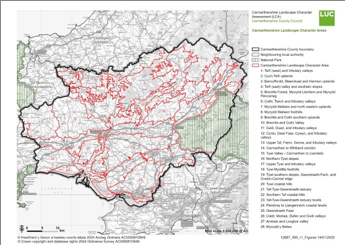
[1] Article 16 of the EU Waste Framework Directive, 2008
[2] ROMP – Review of Old Minerals Permissions
[3] Operations do not involve the extraction of minerals and so no buffer zone is required around the site. Also safeguarded is the marine landing site situated approximately 800m to the east of the Llanelli Sand Dredging site due to its importance in the landing of marine sand